Acquisition Options
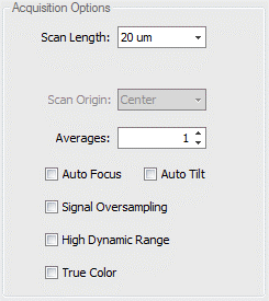
Acquisition Options controls things such as the scan length, scan origin (depending on which motor you are scanning on), averaging, signal over sampling HDR, and true color. The most common reason for dropped pixels in an image is incorrect scan length and/or scan origin. The following sections cover more detail.
7.1: Scan Length and Scan Origin
Scan Length - Selects the vertical scan length. The longer the scan, the greater the height measuring capability, and the longer the measurement time. It is recommended to set to the smallest value that encompasses the part details. When set to Extended, the user enters the length of the scan, which is longer than the selectable lengths. The value entered should be the vertical range of detail in the part plus 10%.
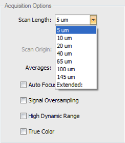
Scan Lengths have two options: It is very important to understand the difference between the two scan length options.
- Numerical scan length choices from 5um-145um (length options change depending on measure type and measure mode) are bi-polar scans which utilize the PZT scanner with only a center scan origin option.
- Extended scans use the Z-motor and you have options for setting the scan origin to top, center, or bottom.
Scan Origin - Selects the location of the part relative to the full scan range when the scan is initiated. Scan profiles for each control option are shown below.
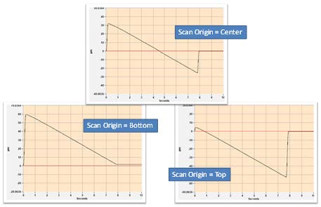
Important to note that the scanner only collects data on the downward part of the motion.
7.2: Averages, Auto Focus, and Auto Tilt
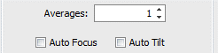
Averages - Specifies the number of measurements to average together to reduce random measurement noise. Averaging increases measurement time.
Auto Focus - Select the check box to perform auto focus before each measurement. The Auto Focus function is useful when the surface of the part being measured does not fall within the current scan range of the sensor. Auto focus will automatically scan at faster rate (depending on the controls) over a longer distance in Z (depending on the controls) to find the surface of the part, then move the sensor head so that the part surface is nominally centered in the middle of the sensor's scan range.
Auto Tilt - Select the check box to perform auto tilt before each measurement.
7.3: Signal oversampling, High Dynamic Range, and True Color
Signal Oversampling - expense of longer measurement time. Signal Oversampling is used to extract very weak signals from challenging surfaces such as those with large roughness or steep slopes. Signal Oversampling can be used in conjunction with CSI or Films measure modes and can be combined with other acquisition options such as Zip Scan, HDR, and True Color. When using oversampling and extended scan, be sure that the SureScan control is set to Off.
High Dynamic Range - Select the check box accommodate parts with a wide variation in reflectivity. This option causes the system to take sequential measurements at up to 3 discrete light levels to accommodate wide variations in part reflectivity. The two measurements are combined to maximize the amount of data and quality of the surface data produced. When the High Dynamic Range mode is checked, an HDR tab is added to the Measurement Setup panel for setting the various light levels.
True Color - Select the check box to enable the collection of a full color surface image for all data points in the topography map.
- Immediately following the metrology scan, a secondary acquisition is automatically executed to collect true color information about the surface at the point of best focus for each data point in the camera.
- Provides full color surface image for all data points in the topography map.
- To display color information in the 2D and 3D surface maps, select the True Color icon in the plot toolbar or context menu.
- Color information is stored with the .datx data file format.