
Atmospheric Circulation
We have seen above that the distribution of solar insolation over the Earth's surface changes over the course of the seasons, with the Sun, in a relative sense, migrating south and then north of the equator over the course of the year—that annual migration, between 23°S and 23°N, defines the region we call the tropics. As the heating by the Sun migrates south and north within the tropics over the course of the year, so does the tendency for rising atmospheric motion. As we have seen, warmer air is less dense than cold air, and where the Sun is heating the surface there is a tendency for convective instability, i.e., the unstable situation of having relatively light air underlying relatively heavy air. Where that instability exists, there is a tendency for rising motion in the atmosphere, as the warm air seeks to rise above the colder air. As a result, there is a tendency for rising air (and with it, rainfall) in a zone of low surface pressure known as the Intertropical Convergence Zone or ITCZ, which is centered roughly at the equator, but shifts north and south with the migration of the Sun about the equator over the course of the year. Due to the greater thermal inertia of the oceans relative to the land surface, the response to the shifting solar heating is more sluggish over the ocean, and the ITCZ shows less of a latitudinal shift with the seasons. By contrast, over the largest land masses (e.g., Asia), the seasonal shifts can be quite pronounced, resulting in dramatics shifts in wind and rainfall patterns such as the Indian monsoon.
The air rising in the tropics then sinks in the subtropics, forming a subtropical band of high surface pressure and low precipitation associated with the prevailing belt of deserts in the subtropics of both hemispheres. The resulting pattern of circulation of the atmosphere is known as the Hadley Cell circulation. In sub-polar latitudes, there is another region of low surface pressure, associated again with rising atmospheric motion and rainfall. This region is known as the polar front. These belts of high and low atmospheric surface pressure, and the associated patterns of atmospheric circulation also shift south and north over the course of the year in response to the heating by the Sun. You can explore the atmospheric patterns using the following animation (1:04):
The animation shows Hadley cells profile, ITCZ, pressure, and precipitation as they vary across a year.
Center of the Hadley cells (ITCZ) sit at 0 degrees in February and October. The cells move 10 to 15 degrees north February through June and then more 10 to 15 degrees south July through December. At any one point ITCZ varies depending on location around the globe.
Pressure has high and low pressure zones. Low pressure sits just north of the Arctic Circle, around the tropic of cancer and Greenland. High pressure sits above the Tropic of Cancer and along the Tropic of Capricorn. January through July most pressure zones south of the tropic of cancer grow while others shrink. July through December most pressure zones north of the Tropic of Capricorn grow and any south shrink. Two exceptions sit along the west coast of North and South America. They are both high-pressure zones and do the opposite of the other zones in their hemisphere.
Precipitation increases in the summer of each hemisphere and decreases in each hemispheres winter.
We have seen above that there is an imbalance between the absorbed incoming short wave solar radiation and the emitted outgoing long wave terrestrial radiation, with a relative surplus within the tropics and a relative deficit near the poles. We, furthermore, noted that the atmosphere and ocean somehow relieve this imbalance by transporting heat laterally, through a process known as heat advection. We are now going to look more closely at how the atmosphere accomplishes this transport of heat. We have already seen one important ingredient, namely the Hadley Cell circulation, which has the net effect of transporting heat poleward from where there is a surplus to where there is a deficit.
Wind patterns in the extratropics also serve to transport heat poleward. The lateral wind patterns are primarily governed by a balance between the previously discussed pressure gradient force (acting in this case laterally rather than vertically), and the Coriolis force, an effective force that exists due to the fact that the Earth is itself rotating. This balance is known as the geostrophic balance.
The Coriolis force acts at right angles to the direction of motion: 90 degrees to the right in the Northern Hemisphere and 90 degrees to the left in the Southern Hemisphere. The pressure gradient force is directed from regions of high surface pressure to regions of low surface pressure. As a consequence, geostrophic balance leads to winds in the mid-latitudes, between the subtropical high pressure belt and the sub-polar low pressure belt of the polar front, blowing from west to east. We call these westerly winds. For reasons that have to do with the vertical thermal structure of the atmosphere, and the combined effect of the geostrophic horizontal force balance and hydrostatic vertical force balance in the atmosphere, the westerly winds become stronger aloft, leading to the intense regions of high wind known as the jet streams in the mid-latitude upper troposphere.
Conversely, winds in the tropics tend to blow from east to west. These are known as easterly winds or, by the perhaps more familiar term, the trade winds. In the Northern Hemisphere, geostrophic balance implies counter-clockwise rotation of winds about low pressure centers and clockwise rotation of winds about high pressure centers. The directions are opposite in the Southern Hemisphere.
Due to the effect of friction at the Earth's surface, there is an additional component to the winds which blows out from high pressure centers and in towards low pressure centers. The result is spiraling in (convergence) towards low pressure centers and a spiraling out (divergence) about high pressure centers. The convergence of the winds toward the low pressure centers is associated with the rising atmospheric motion that occurs within regions of low surface pressure. The divergence of the winds away from the high pressure centers is associated with the sinking atmospheric motion that occurs within regions of high atmospheric pressure.
The inward spiraling low pressure systems in mid-latitudes constitute the polar front, which separates the coldest air masses near the poles from the warmer air masses in the subtropics. In fact, it is the unstable property of having clashing air masses with vastly different temperature characteristics, known as baroclinic instability, that is responsible for the existence of extratropical cyclones. The energy that drives the extratropical cyclones comes from the work done as surface air is lifted along frontal (i.e., cold front and warm front) boundaries. These extratropical storm systems relieve high-latitude deficit of radiation by mixing cold polar and warm subtropical air and, in so doing, transporting heat poleward, along the latitudinal temperature gradient.
You can explore the resulting large-scale pattern of circulation of the global atmosphere in the following animation (1:05):
Ocean Circulation (Gyres, Thermohaline Circulation)
While we have focused primarily on the atmosphere thus far, the oceans, too, play a key role in relieving the radiation imbalance by transporting heat from lower to higher latitudes. The oceans also play a key role in both climate variability and climate change, as we will see. There are two primary components of the ocean circulation. The first component is the horizontal circulation, characterized by wind-driven ocean gyres.
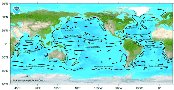
The major surface currents are associated with the ocean gyres. These include the warm poleward western boundary currents such as the Gulf Stream, which is associated with the North Atlantic Gyre, and the Kuroshio Current associated with the North Pacific Gyre. These gyres also contain cold equatorward eastern boundary currents such as the Canary Current in the eastern North Atlantic and the California Current in the western North Atlantic. Similar current systems are found in the Southern Hemisphere. The horizontal patterns of ocean circulation are driven by the alternating patterns of wind as a function of latitude, and, in particular, by the tendency for westerly winds in mid-latitudes and easterly winds in the tropics, discussed above.
An important additional mode of ocean circulation is the thermohaline circulation, which is sometimes referred to as the meridional overturning circulation or MOC. The circulation pattern is shown below:
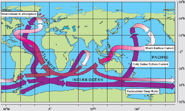
By contrast with the horizontal gyre circulations, the MOC can be viewed as a vertical circulation pattern associated with a tendency for sinking motion in the high-latitudes of the North Atlantic, and rising motion more broadly in the tropics and subtropics of the Indian and Pacific Ocean. This circulation pattern is driven by contrasts in density, which are, in turn, largely due to variations in both temperature and salinity (hence the term thermohaline). The sinking motion is associated with relatively cold, salty surface waters of the sub-polar North Atlantic, and the rising motion with the relatively warm waters in the tropical and subtropical Pacific and Indian ocean.
The picture presented in Figure 1.11 above is a highly schematized and simplistic description of the actual vertical patterns of circulation in the ocean. Nonetheless, the conveyor belt is a useful mnemonic. The northward surface branch of this circulation pattern in the North Atlantic is sometimes erroneously called the Gulf Stream. The Gulf Stream, as discussed above, is part of the circulating waters of the wind-driven ocean gyre circulation. By contrast, the northward extension of the thermohaline circulation in the North Atlantic, is rightfully referred to as the North Atlantic Drift. This current system represents a net transport of warm surface waters to higher latitudes in the North Atlantic and is also an important means by which the climate system transports heat poleward from lower latitudes. Changes in this current system are speculated as having played a key role in past and potential future climate changes, as will be explored later in this course.