The preceding discussion leads me to revise my working definition:
As I mentioned earlier, a geographer named David Cowen defined GIS as a decision-support tool that combines the capabilities of a relational database management system with the capabilities of a mapping system (1988). Cowen cited an earlier study by William Carstensen (1986), who sought to establish criteria by which local governments might choose among competing GIS products. Carstensen chose site selection as an example of the kind of complex task that many organizations seek to accomplish with GIS. Given the necessary database, he advised local governments to expect that a fully functional GIS should be able to identify property parcels that are:
- at least five acres in size;
- vacant or for sale;
- zoned commercial;
- not subject to flooding;
- located not more than one mile from a heavy duty road; and
- situated on terrain whose maximum slope is less than ten percent.
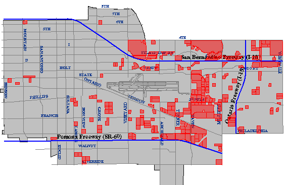
The first criterion--identifying parcels five acres or more in size--might require two operations. As described earlier, a mapping system ought to be able to calculate automatically the area of a parcel. Once the area is calculated and added as a new attribute into the database, an ordinary database query could produce a list of parcels that satisfy the size criterion. The parcels on the list might also be highlighted on a map, as in Figure 1.11.1, below.
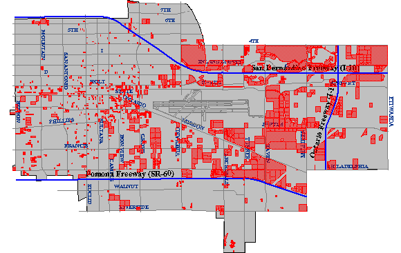
The ownership status of individual parcels would be an attribute of a property database maintained by a local tax assessor's office. Parcels whose ownership status attribute value matched the criteria "vacant" or "for sale" could be identified through another ordinary database query.
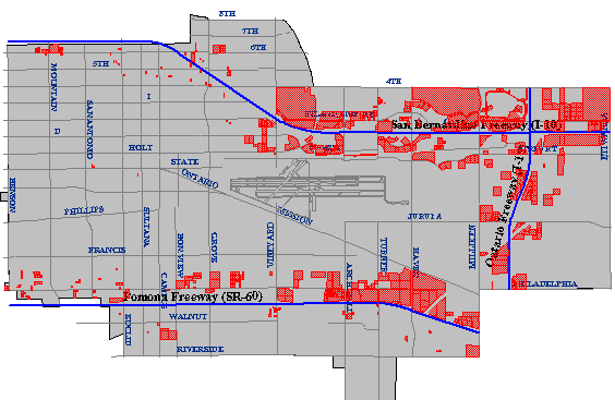
Carstensen's third criterion was to determine which parcels were situated within areas zoned for commercial development. This would be simple if authorized land uses were included as an attribute in the community's property parcel database. This is unlikely to be the case, however, since zoning and taxation are the responsibilities of different agencies. Typically, parcels and land use zones exist as separate paper maps. If the maps were prepared at the same scale, and if they accounted for the shape of the Earth in the same manner, then they could be superimposed one over another on a light table. If the maps let enough light through, parcels located within commercial zones could be identified.
The GIS approach to a task like this begins by digitizing the paper maps, and by producing corresponding attribute data files. Each digital map and attribute data file is stored in the GIS separately, like separate map layers. A fully functional GIS would then be used to perform a spatial intersection that is analogous to the overlay of the paper maps. Spatial intersection, otherwise known as map overlay, is one of the defining capabilities of GIS.
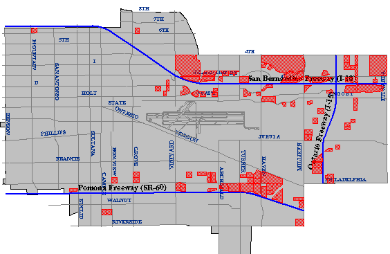
Another of Carstensen's criteria was to identify parcels located within one mile of a heavy-duty highway. Such a task requires a digital map and associated attributes produced in such a way as to allow heavy-duty highways to be differentiated from other geographic entities. Once the necessary database is in place, a buffer operation can be used to create a polygon feature whose perimeter surrounds all "heavy duty highway" features at the specified distance. A spatial intersection is then performed, isolating the parcels within the buffer from those outside the buffer.
To produce a final list of parcels that meet all the site selection criteria, the GIS analyst might perform an intersection operation that creates a new file containing only those records that are present in all the other intermediate results.
I created the maps shown above in 1998 using the Geographic Information Web Server of the City of Ontario, California. Although it is no longer supported, the City of Ontario was one of the first of its kind to provide much of the functionality required to perform a site suitability analysis online. Today, many local governments offer similar Internet map services to current and prospective taxpayers.
Try This!
Find an online site selection utility similar to the one formerly provided by the City of Ontario.