The need to redraw voting district boundaries every ten years was one of the motivations that led the Census Bureau to create its MAF/TIGER database. Like voting districts, many other kinds of service area boundaries need to be revised periodically. School districts are a good example. The state of Massachusetts, for instance, has adopted school districting laws that are similar in effect to the constitutional criteria used to guide congressional redistricting. The Framingham (Massachusetts) School District's Racial Balance Policy once stated that "each elementary and middle school shall enroll a student body that is racially balanced. ... each student body shall include a percentage of minority student, which reflects the system-wide percentage of minority students, plus or minus ten percent. ... The racial balance required by this policy shall be established by redrawing school enrollment areas" (Framingham Public Schools 1998). And bus routes must be redrawn as enrollment area boundaries change.
The Charlotte-Mecklenberg (North Carolina) public school district also used racial balance as a districting criterion (although its policy was subsequently challenged in court). Charlotte-Mecklenberg consists of 133 schools, attended by over 100,000 students, about one-third of whom ride a bus to school every day. District managers are responsible for routing 3,600 bus routes, traveling a total of 82,000 daily miles. A staff of eight routinely uses GIS to manage these tasks. GIS could not be used unless up-to-date, appropriately attributed, and topologically encoded data were available.
Another example of service area analysis is provided by the City of Beaverton, Oregon. In 1997, Beaverton officials realized that 25 percent of the volume of solid waste that was hauled away to landfills consisted of yard waste, such as grass clippings and leaves. Beaverton decided to establish a yard waste recycling program, but it knew that the program would not be successful if residents found it inconvenient to participate. A GIS procedure called allocation was used to partition Beaverton's street network into service areas that minimized the drive time from residents' homes to recycling facilities. Allocation procedures require vector-format data that includes the features, attributes, and topology necessary to calculate travel times from all residences to the nearest facility.
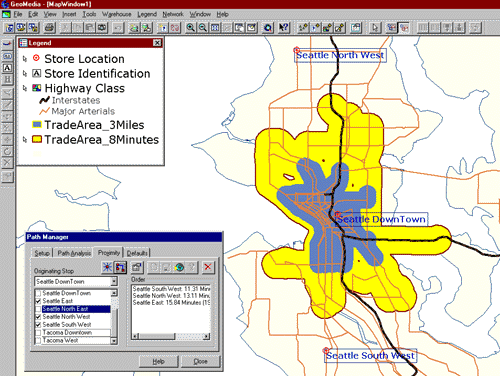
Naturally, private businesses concerned with delivering products and services are keenly interested in service area delineation. The screen capture above shows two trade areas surrounding a retail store location ("Seattle Downtown") in a network database.
Former student Saskia Cohick (Winter 2006), who was then GIS Director for Tioga County, Pennsylvania, contributed another service area problem: "This is a topic that local governments are starting to deal with ... To become Phase 2 wireless capable (that is, capable of finding a cell phone location from a 911 call center within 200 feet of the actual location), county call centers must have a layer called ESZs (Emergency Service Zones). This layer will tell the dispatcher who to send to the emergency (police, fire, medical, etc). The larger problem is to reach an agreement between four fire companies (for example) as to where they do or do not respond."