Altimetry is the measurement of elevation. Earlier chapters discussed land survey methods used to calculate terrain elevations in the field (leveling and GPS), and photogrammetric methods used to measure terrain elevations from stereoscopic images produced from pairs of aerial photographs. Land surveys and photogrammetric surveys yield high quality elevation data, but they are also time-consuming and expensive to conduct.
Radar (and laser) altimetry provides more efficient solutions when elevation data are needed for larger areas. For example, you have heard about the Shuttle Radar Topography Mission (SRTM), which used dual radar altimeters to produce 30-meter elevation data as well as stereoscopic terrain imagery for the Earth's land surface between 60° North and South latitude. Next, we'll consider how radar altimetry has been used to produce a global seafloor elevation data set.
Predicting seafloor depths
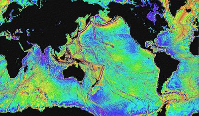
Detailed maps of the Earth's bathymetry (the topography of the ocean floor) are needed to study plate tectonics, to locate potential offshore oil and mineral deposits, and to route undersea telecommunications cables, among other things. Coarse global data sets (such as ETOPO2, with its 2-minute grid resolution) are inadequate for such purposes. Slow-moving surface vessels equipped with sonar instruments have mapped only a small fraction of the Earth's bathymetry.
Data produced by radar sensors like ERS-1 have been used to produce global seafloor elevation data. Radar pulses cannot penetrate the deep ocean, but they can be used to accurately measure the height of the sea surface relative to a global ellipsoid such as WGS 84. As you know, the geoid is defined as mean sea level adjusted to account for the effects of gravity. Geodesists invent reference ellipsoids like WGS 84 to approximate the geoid's shape with a figure that is easier to define mathematically. Because gravity varies with mass, the geoid bulges slightly above the ellipsoid over seamounts and undersea volcanoes, which often rise 2000 meters or more above the ocean floor. Sea surface elevation data produced by satellite altimeters can thus be used to predict fairly detailed bathymetry, as shown in Figure 8.23.1, below.