So far, you've read that remote sensing systems measure electromagnetic radiation, and that they record measurements in the form of raster image data. The resolution of remotely sensed image data varies in several ways. As you recall, resolution is the least detectable difference in a measurement. In this context, three of the most important kinds are spatial resolution, radiometric resolution and spectral resolution.
Spatial resolution refers to the coarseness or fineness of a raster grid. The grid cells in high resolution data, such as those produced by digital aerial imaging or by the Ikonos satellite, correspond to ground areas as small or smaller than one square meter. Remotely sensed data whose grid cells range from 15 to 80 meters on a side, such as the Landsat ETM+ and MSS sensors, are considered medium resolution. The cells in low resolution data, such as those produced by NOAA's AVHRR sensor, are measured in kilometers. (You'll learn more about all these sensors later in this chapter.)
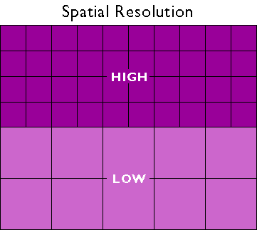
The higher the spatial resolution of a digital image, the more detail it contains. Detail is valuable for some applications, but it is also costly. Consider, for example, that an 8-bit image of the entire Earth whose spatial resolution is one meter could fill 78,400 CD-ROM disks, a stack over 250 feet high (assuming that the data were not compressed). Although data compression techniques reduce storage requirements greatly, the storage and processing costs associated with high resolution satellite data often make medium and low resolution data preferable for analyses of extensive areas.
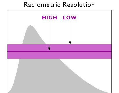
A second aspect of resolution is radiometric resolution, the measure of a sensor's ability to discriminate small differences in the magnitude of radiation within the ground area that corresponds to a single raster cell. The greater the bit depth (number of data bits per pixel) of the images that a sensor records, the higher its radiometric resolution. The AVHRR sensor, for example, stores 210 bits per pixel, as opposed to the 28 bits that the Landsat sensors record. Thus, although its spatial resolution is very coarse (~4 km), the Advanced Very High Resolution Radiometer takes its name from its high radiometric resolution.
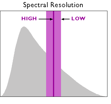
Finally, there is spectral resolution, the ability of a sensor to detect small differences in wavelength. For example, panchromatic film is sensitive to a broad range of wavelengths. An object that reflects a lot of energy in the green portion of the visible band would be indistinguishable in a panchromatic photo from an object that reflected the same amount of energy in the red band, for instance. A sensing system with higher spectral resolution would make it easier to tell the two objects apart.