3. Vector Extracts from MAF/TIGER
The Census Bureau began to develop a digital geographic database of 144 metropolitan areas in the 1960s. By 1990, the early efforts had evolved into TIGER: a seamless digital geographic database that covered the whole of the United States and its territories. As discussed in the previous page, MAF/TIGER succeeded TIGER in the lead-up to the 2010 Census.
TIGER/Line Shapefiles are digital map data products extracted from the MAF/TIGER database. They are freely available from the Census Bureau and are suitable for use by individuals, businesses, and other agencies that don’t have direct access to MAF/TIGER.
This section outlines the geographic entities represented in the MAF/TIGER database, describes how a particular implementation of the vector data model is used to represent those entities, and considers the accuracy of digital features in relation to their counterparts on the ground. The following page considers characteristics of the “Shapefile” data format used to distribute digital extracts from MAF/TIGER.
Geographies Represented in TIGER and Shapefile Extracts
The MAF/TIGER database is selective. Only those geographic entities needed to fulfill the Census Bureau’s operational mission are included. Entities that don't help the Census Bureau conduct its operations by mail, or help field workers navigate a neighborhood, are omitted. Terrain elevation data, for instance, are not included in MAF/TIGER. A comprehensive list of the "feature classes” and “superclasses” included in MAF/TIGER and Shapefiles can be found via the MAF/TIGER Feature Class Codes (MTFCCs) [1] link on the list of Geographic Codes on the Census.gov > Geography > Reference [2] page. Examples of superclasses include:
- potential living quarters (e.g., sites of shelters, retirement homes, prisons, dormitories);
- road/path features (e.g., primary roads, secondary roads, local neighborhood roads);
- hydrographic features (e.g., stream/river, lake/pond, ocean/sea);
- miscellaneous linear features (e.g., pipeline, powerline, fence line);
- tabulation areas (e.g., county or equivalent, tract, block group, block).
| MTFCC | FEATURE CLASS | SUPERCLASS | POINT | LINEAR | AREAL | FEATURE CLASS DESCRIPTION |
|---|---|---|---|---|---|---|
| S1400 | Local Neighborhood Road, Rural Road, City Street | Road/Path Features | N | Y | N | Generally a paved non-arterial street, road, or byway that usually has a single lane of traffic in each direction. Roads in this feature class may be privately or publicly maintained. Scenic park roads would be included in this feature class, as would (depending on the region of the country) some unpaved roads. |
| S1500 | Vehicular Trail (4WD) | Road/Path Features | N | Y | N | An unpaved dirt trail where a four-wheel drive vehicle is required. These vehicular trails are found almost exclusively in very rural areas. Minor, unpaved roads usable by ordinary cars and trucks belong in the S1400 category. |
| S1630 | Ramp | Road/Path Features | N | Y | N | A road that allows controlled access from adjacent roads onto a limited access highway, often in the form of a cloverleaf interchange. These roads are unaddressable. |
Note also that neither the MAF/TIGER database nor TIGER/Line Shapefiles include the population data collected through questionnaires and by census takers. MAF/TIGER merely provides the geographic framework within which address-referenced census data are tabulated.
Try This!
Exploring Available TIGER/Line Shapefiles
In this Try This! (One of 3 dealing with TIGER/Line Shapefiles), you are going to explore which TIGER/Line Shapefiles are available for download at various geographies and what information those files contain. We will be exploring the 2009 and 2010 versions of the TIGER/Line Shapefile data sets. Versions from other years are available. Feel free to investigate those, too.
- Follow this link to get to the TIGER Products page [3] of the Census Bureau website, then follow the TIGER/Line Shapefiles link found under Which product should I use? to get to the Geography page.
- Link to the 2010 TIGER/Line Shapefiles via the 2010 tab link.
- Select Download, and then, from the expanded list, choose Web Interface.
- Expand the pick list under Select a layer type. Spend some time choosing different entries from the layer pick list and then, using the Submit button to navigate through the sub layers, taking note of when you are offered access to a Download button. Take note of a couple of things. (1) Some of the pick lists make a selection available that allows you to download a shapefile dataset for the entire country. (2) For some of the choices, you must navigate to the County level before the Download button is available.
- Before you continue, click on the TIGER/Line Shapefiles Main link to get back to the TIGER/Line Shapefiles page.
As stated above, we want you to get a sense of the sorts of data that are available for the various geographies -- from the county to the national level. Perusing the various layers as I had you doing above makes it difficult to make an overall assessment of what data there are at a given geographic scale. Fortunately for our purposes, the Census has provided a convenient table to help us in this regard.
From the TIGER/Line Shapefiles page,
- Select the 2010 tab again.
- Select File Availability.
Study the table that appears. - Note that there are columns titled State- and County-based Files, Nation-based Files, and American Indian Area-based Files.
- Compare the geographies (the Layer column) which are available in the Nation-Based Files category to those available in the State-Based Files category.
What files are available for a state that are not available for the whole nation? Can you think of reasons why these are not available as a single national file?
- Now, compare the State-Based Files category to the County-Based Files category.
What files available at the state level are also available at the county-level? Once again, share your thoughts with your peers.
Geometric Primitives
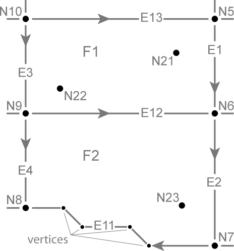
Like other implementations of the vector data model, MAF/TIGER represents geographic entities using geometric primitives including nodes (point features), edges (linear features), and faces (area features). These are defined and illustrated below.
- Nodes (labeled “N” in the illustration below) are "0-dimensional," consisting only of a single pair of latitude and longitude coordinates.
- Nodes N21-23 are isolated nodes. That is, they are not end points of edges.
- Edges (labeled “E” in the illustration below) are 1-dimensional linear primitives used to represent streets, railroads, pipelines, and rivers.
- The end points of an edge are called connecting nodes.
- Each edge is assigned a direction, denoted by the arrowheads. The directionality of the edge allows the designation of a Start Node and an End Node. The Start Node of edge E12 below is N9, and the End Node is N6.
- An edge may have intermediate points called vertices that define its shape.
- Faces (labeled “F” in Figure 4.4.1, below) are the 2-dimensional geometric primitives used to represent entities like blocks, counties, and voting districts. A face is a polygon bounded by edges.
- The directionality of an edge also allows left and right faces to be designated. Face F1 is on the left of edge E12 and face F2 is to the right.
Geometric Accuracy
Until recently, the geometric accuracy of the vector features encoded in TIGER was notoriously poor (see figure below). How poor? Through 2003, the TIGER/Line metadata [4] stated that
Coordinates in the TIGER/Line files have six implied decimal places, but the positional accuracy of these coordinates is not as great as the six decimal places suggest. The positional accuracy varies with the source materials used, but generally, the information is no better than the established National Map Accuracy standards for 1:100,000-scale maps from the U.S. Geological Survey (Census Bureau 2003).
Try This!
Having performed scale calculations in Chapter 2, you should be able to calculate the magnitude of error (ground distance) associated with 1:100,000-scale topographic maps. Recall that the allowed error for USGS topographic maps at scales of 1:20,000 or smaller is 1/50 inch (see the nationalmap standards pdf [5]).
Accuracy Improvement
Starting in 2002, in preparation for the 2010 census, the Census Bureau commissioned a six-year, $200 million MAF/TIGER Accuracy Improvement Project (MTAIP). One objective of the effort was to use GPS to capture accurate geographic coordinates for every household in the MAF. Another objective was to improve the accuracy of TIGER's road/path features. The project aimed to adjust the geometry of street networks to align within 7.6 meters of street intersections observed in orthoimages or measured using GPS. The corrected streets are necessary not just for mapping, but for accurate geocoding. Because streets often form the boundaries of census areas, it is essential that accurate household locations are associated with accurate street networks.
MTAIP integrated over 2,000 source files submitted by state, tribal, county, and local governments. Contractors used survey-grade GPS to evaluate the accuracy of a random sample of street centerline intersections of the integrated source files. The evaluation confirmed that most but not all features in the spatial database equal or exceed the 7.6-meter target. Uniform accuracy wasn’t possible due to the diversity of local source materials used, though this accuracy is the standard in the "All Lines" Shapefile extracts. The geometric accuracy of particular feature classes included in particular shapefiles is documented in the metadata associated with that shapefile extract.
MTAIP was completed in 2008. In conjunction with the continuous American Community Survey and other census operations, corrections and updates are now ongoing. TIGER/Line Shapefile updates are now released annually.