Chapter 1 - Introduction
Chapter 1 Overview
The Geospatial Intelligence Professional
The Geospatial Intelligence professional is a “knowledge worker” or “symbol analyst” (a term used by the U.S. Department of Labor) who carries out multi-step operations, manipulates abstract symbols, addresses abstract and complex ideas, acquires new information, and must remain mindful enough to recognize change. Successful knowledge work, like all work, requires study and practice. Professionalism in the area calls for broad experience and understanding of the entire Intelligence Community. The individual who is only interested in geospatial technology, as central as it is to the discipline, is not fully a Geospatial Intelligence professional. Nor is the technical expert in GIS or remote sensing ipso facto a Geospatial Intelligence professional.
What is Intelligence and What is Geospatial Intelligence?
What is Intelligence?
In his 2006 book, Intelligence: From Secrets to Policy, Lowenthal (p 8) defines intelligence in three ways:
- Intelligence as a process
A means by which certain types of information are required and requested, collected, analyzed, and disseminated, and as the way in which certain types of covert action are conceived and conducted. - Intelligence as a product
A knowledge product resulting from analyzes and intelligence operations themselves. - Intelligence as an organization
Entities that carry out various functions for Intelligence.
Lowenthal points out that to the average person, intelligence is about secrets and spying. However, according to Lowenthal, this view of intelligence as primarily secrets misses the important point that intelligence is ultimately information about anything that can be known regardless of how it is discovered. More specifically, intelligence is information that meets the needs of a decision maker, and has been collected, processed, narrowed, and offered to meet those needs. This is to say, intelligence can be considered a specific subset of the broader category of information. It also can be said that all intelligence is information but not all information is intelligence. A key point is that Intelligence and the entire intelligence process responds to the needs of the decision makers. Lowenthal also points out that many think of intelligence in terms of government and/or military information. This is certainly a major use of intelligence, but political, business, social, environmental, health, espionage, terrorism, and cultural intelligence also intelligence. Lowenthal states a fundamental that Intelligence is not about truth (Lowenthal, p 6) and it is more accurate to think of intelligence as "proximate reality." Intelligence analysts do their best to arrive at a accurate approximation of what is going on but they can rarely be assured that their best analytic results are true. Therefore, the is "intelligence products that are reliable, unbiased, and free from politicization. In other words, to develop a product that is as close to the truth as it can be humanly possible to discern." (Lowenthal, p 6).
De Jure Definition of Geospatial Intelligence
De jure is a Latin term which means, "by law" which is commonly contrasted to de facto which means, "concerning the fact" or in practice but not necessarily ordained by law. The NIMA Act of 1996 establishing the National Imagery and Mapping Agency and the subsequent amended language in the 2003 Defense Authorization Act as codified in the U.S. Code governs the mission of the National Geospatial-Intelligence Agency (NGA). The de jure definition of Geospatial Intelligence is found in U.S. Code Title 10, §467:
The term "geospatial intelligence" means the exploitation and analysis of imagery and geospatial information to describe, assess, and visually depict physical features and geographically referenced activities on the earth. Geospatial intelligence consists of imagery, imagery intelligence, and geospatial information.
The moniker GEOINT has become associated with geospatial Intelligence with a specific meaning and context. It has often been said that the 2003 renaming of NIMA to NGA recognized the emergence of geospatial information as an intelligence source in its own right, which is termed GEOINT. The term GEOINT connotes a source of intelligence like HUMINT, MASINT, COMINT, ELINT, SIGINT, IMINT. GEOINT is uniquely multi-source in that it integrates and enriches information collected by the other INTs into a spatiotemporal context.
The de jure definition drives us to focus on Geographic Information Systems and digital remote sensing, since these technologies, as a substantial component of workflows such as TPED (Tasking, Processing, Exploitation, and Dissemination), heavily leverage spatial data handling and image processing technologies to transform geospatial data. However, there is a growing recognition that GEOINT “must move from an emphasis on data and analysis to an emphasis on knowledge” (Priorities for GEOINT Research at the National Geospatial-Intelligence Agency, The National Academies Press, 2006, P. 9). Here, the use of the term knowledge means the confident understanding of a subject with the ability to use it for a specific purpose appropriately. This is to say, geospatial knowledge creation involves much more than automated data handling and is a complex cognitive process involving perception, learning, communication, association and reasoning.
De Facto Definition of Geospatial Intelligence
We would like to suggest the following as an emerging definition of Geospatial Intelligence, which might carry the moniker of GeoIntel, as a means to guide the preparation of the geospatial professional:
Geospatial Intelligence is actionable knowledge, a process, and a profession. It is the ability to describe, understand, and interpret so as to anticipate the human impact of an event or action within a spatiotemporal environment. It is also the ability to identify, collect, store, and manipulate data to create geospatial knowledge through critical thinking, geospatial reasoning, and analytical techniques. Finally, it is the ability to ethically collect, develop, and present knowledge in a way that is appropriate to the decision-making environment.
In this definition, Geospatial Intelligence doesn’t just provide the means by which to answer the questions of what?, when?, and where?, but also how?, why?, and what is the significance? Central to this proposed definition is the notion that the best geospatial intelligence resource is an educated analyst and that intelligence is about nothing if not about “out-thinking” your opponent. For all the appropriate emphasis on technologies, methodologies, tools, and infrastructure, people still are the most precious resource.
Intelligence Cycle and Process
Intelligence Analysis in a Cycle
Analysis resides within the larger intelligence cycle. The intelligence cycle determines the daily activities of the Intelligence Community. It starts with the needs of the intelligence "consumers' such as policymakers, military officials, and other decision makers who need intelligence for their activities. These requirements are sorted and prioritized within the Intelligence Community and are used to drive the collection activities of the Intelligence Community. The cycle, as depicted in the figure below, is repeated until an intelligence requirement has been satisfied.
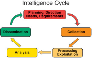
The Intelligence Cycle is a concept that describes the general intelligence process in both a civilian or military intelligence agency or in law enforcement. The cycle is typically represented as a closed path of activities. Problems with a closed loop include an overall process that is no better than its weakest component and stove piping. In the traditional intelligence use of the term, stove piping keeps the output of different collection systems separated from one another. Stove piping prevents one discipline from cross-checking another and bypassing the regular analysis of raw intelligence by sending only raw intelligence that supports a particular position to the leadership.
Analysis is using information about the context of a situation, characterizing the known observables, and applying the appropriate statements of probability to anticipate future situations. Descriptions of the anticipated situations are developed from what may be inaccurate or deliberately deceptive information; therefore, the analyst must correlate the similarities among observations and develop a common "truth." A set of repeatable and useful problem-solving approaches is helpful and essential for analysts. Because of the nature of the intelligence problem and work, an analytic approach must be tolerant of deceptive information far more than the scientist performing an experiment. According to Richards Heuer [2], intelligence analysis involves incremental, iterative, refinement.
Intelligence Process
The term "intelligence process" refers to the steps of the cycle. Intelligence, as practiced in the United States, is commonly thought of as having five steps. Lowenthal (2006, p 55) added two phases for seven phases of the intelligence process as (1) requirements, (2) collection, (3) processing and exploitation, (4) analysis and production, (5) dissemination, (6) consumption, and (7) feedback. The following paraphrases Lowenthal (p 55):
- Requirements.
Identifying requirements means defining those questions to which intelligence is expected to make a contribution. Requirements also means specifying the collection of certain types of intelligence. The impulse is to say that all policy areas have intelligence requirements, which they do. However, since intelligence capabilities are limited, priorities must be set. - Collection.
Once requirements and priorities have been established, the intelligence is collected. Some requirements have specific types of collection; some may require several types of collection. Making these decisions is a key issue and the question of how much can or should be collected to meet each requirement. - Processing and Exploitation.
Collection produces information which must undergo processing and exploitation before it can be regarded as intelligence and given to analysts. Conversion includes translations, decryption, and interpretation. - Analysis and Production.
Analysis and production includes the integration, evaluation, and analysis of all available data, and the preparation of intelligence products, including quickly developed single-source, event-oriented reports and longer term all-source and intelligence studies. "All-source" intelligence analysis is done exclusively by the CIA, DIA, and the State Department's Bureau of Intelligence and Research. All-source analysts complete a more thorough evaluation and assessment of the collected information by integrating the information from other classified and unclassified sources.
Significantly, according to Lowenthal, most discussions of the intelligence process end with the dissemination and the intelligence having reached the policy makers. However, Lowenthal bundles dissemination with consumption and adds feedback:
- Dissemination and Consumption
Dissemination and Consumption are taken together by Lowenthal. The process of dissemination, or the process of moving intelligence from producers to consumers, is largely standardized, with consumption being assumed in the 5-step process. However, Lowenthal points out that policy makers are not pressed into action by the receipt of intelligence, and if and how they consume intelligence is key (Lowenthal p. 62). - Feedback.
A dialog between intelligence consumers and producers should occur before and continue after the intelligence has been received. The analyst should have some sense of how well their intelligence requirements are being met and address any adjustments that need to be made. Feedback assesses the degree to which the finished intelligence addresses the needs of the intelligence consumer and will determine if further collection and analysis is required.
What is Intelligence Analysis?
Puzzles and Mysteries
The following discussion is a paraphrase of the RAND report Assessing the Tradecraft of Intelligence Analysis [3] (Chapter 2, pages 3-12).The intelligence cycle can be contrasted with the intelligence analytic cycle which, according to the RAND report, typically includes three forms of analysis:
- technical processing as a form of analysis
- single discipline analysis such as GEOINT
- all-source analysis
The distinction between the first two types and all-source analysis is being blurred because of this use of tools, such as GIS, to integrate multiple intelligence sources. As such, some suggest a continuum of analysis from the collection system at one end to analysis at the other. Along this continuum, there is a transition where the data is used to support analysis. According to RAND, past this transitional area, analysis splits into:
- puzzle-solving
- mystery-framing
According to RAND:
- A puzzle tests the ingenuity of the solver to use information. Here one pieces together the information pieces in a logical way in order to come up with the solution, sort of like, the overlay process in GIS. Puzzle-solving in GIS involves pulling together many sources of data and information and, using that evidence, identifies new spatial patterns or trends and develops new knowledge.
- Mystery-framing includes political and societal questions related to humans. Anticipating human actions, e.g., where will a terrorist strike next, always involves subjective judgment which is less certain and more prone to biases. The analytic logic is also significant different for mysteries because there is no definitive solution. Mysteries can only be generally framed and made sense of which suggested that the argument is as important as the evidence. In the geospatial realm, information is always lacking because of accuracy, age, detail, or relevance. Therefore, many geospatial intelligence questions are mysteries. Mysteries involving human perceptions benefit from experience.
Is Geospatial Intelligence Art or Science?
It should be no surprise that there are competing views of geospatial analysis. One school is that intuition, experience, and subjective judgment are key. Analysis here is an art, and non-quantitative methods predominate. Another school is that quantitative data and analysis using such tools as GIS are most relevant. Intelligence analysis here is science-like, and quantitative methods as applied in spatial analysis predominate. This controversy somewhat mirrors a long-standing debate in the intelligence community: if good analysis depends largely on subjective, intuitive judgment (an art) or systematic analytic methods (a science). Understanding this question is important to the person when developing an effective approach to geospatial intelligence creation. To help understand these points of view, I will define the terms using the Merriam-Webster Collegiate Dictionary, tenth edition, as:
- Art - the conscious use of skill and creative imagination in the production of anesthetic objects.
- Science - knowledge or a system of knowledge covering general truths or the operation of general laws, especially as obtained and tested through the scientific method.
Interestingly, there are those that consider integrative geospatial data tools, such as those found in GIS, as primarily aids to intuition and experience-based analysis and not the application of quantitative analytic methods. This seems contrary to the technical capabilities GIS brings to the geospatial intelligence. It is correct to say that there is no certain dividing line between art and science. Some contend there is no diving line at all and a pure scientific approach to geospatial analysis is impossible. The dissatisfaction with the push toward a science only perspective in GIS has been seen as a step backward by some. In this thinking, GIS’s models and analysis methods are not rich enough in geographical concepts and understanding to accurately reflect reality.
Geospatial intelligence is geospatial analysis, and geospatial analysis, at its core, is geography. Geography is both the conscious use of creative imagination in the representations of the earth and the science of developing general truths about the earth. For something to be automatable, it must be modeled and the facts (inputs) quantified. Since a model is a simplified abstract view of the complex reality, the model represents a limited set of rules which allows analysts to work out an answer if they have certain information. Quantifiability of the information is important because unquantifiable inputs cannot be tested, and thus unquantifiable results can neither be duplicated nor contradicted. However, we know that reliable models and data are not available for all analysis.
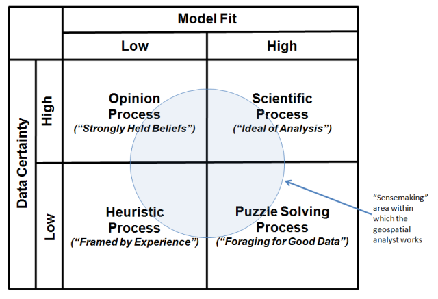
Pulling all of these thoughts together, the table in the image below categorizes the broad types of geospatial analysis. The upper right quadrantof the matrix identifies the ideal of GIS analysis as a Scientific Processin which there is good knowledge of the data and models surrounding an output. In the model, analysts understand the problem that confronts them and can take into account the key factors that bear on the problem. The notion of fixed-in-advance standard procedures typically plays an important role in such geospatial analysis.
However, many of the analytic tasks in geospatial intelligence fall outside of the scientific quadrant. Consider the Puzzle Solving Process (lower right) quadrant in which there is agreement on models, but disagreement on data. The notion of "foraging" for the data to solve the problem plays an important role in such analysis.
Analysis as an Opinion Process (upper left quadrant) is the opposite. In this analytic environment, there is agreement on data, but disagreement on model. Analysis is characterized by analysts involved in a struggle for influence, and decisions emerge from that struggle. This kind of analysis necessitates bargaining, accommodation, and consensus, as well as controversy. The bottom line is that conclusions are most often the result of bargaining between diverse and strongly held beliefs.
Intelligence analysis as a Heuristic Process (lower left quadrant) is the most contentious, with disagreement on data and models. Under these conditions, science and technology tools have significantly less direct relevance. Here, conclusions depend on parameters that change over the period the analysis is being made. As a consequence, the analytic process is experience-based. In the end, this is the framing of questions. They can only be framed, not solved, and thus the logic of argument and analysis is as important as the evidence.
Click to expand to provide more information
The "sensemaking" area within which the geospatial analyst works is the Puzzle Solving Process area.
| Model Fit - Low | Model Fit - High |
|---|---|
| Opinion Process ("strongly held beliefs") Data Certainty: high |
Scientific Process ("Ideal of Analysis") Data Certainty: high |
| Heuristic Process ("Framed by Experience") Data Certainty: low |
Puzzle Solving Process ("Foraging for Good Data") Data Certainty: high |
Is geospatial intelligence an art or science? Analytic problems can fall into any of the four quadrants ---- you, the analyst, need to understand the problem solving environment and the nature of the problem solving process. The term “sensemaking” is used as a term to describe the analysis process and incorporates traits associated with the classical definitions of both “art” and “science.” Sensemaking is more formally defined as the deliberate effort to understand events using explanatory structure that defines entities by describing their relationship to other entities. Data elicit and help to construct the frame; the frame defines, connects and filters the data.