Chapter 5 - Grounding in the Problem and Team Building
Chapter 5 Overview
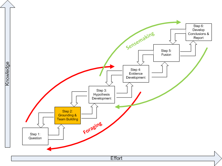
This chapter discusses the second step of the SGAM, highlighted below in gold, Grounding in the Problem and Team Building.
Obviously, an analyst must have a base of knowledge to work with before starting analysis. The significance of geospatial information is always a joint function of the nature of the information and the context in which it is interpreted. When dealing with a new and unfamiliar subject, the uncritical and relatively non-selective accumulation and review of information is an appropriate first step. This is a process of absorbing geospatial information, not analyzing it. Another view of this process is as a problem reduction effort. In this view, a problem is decomposed into a structured set of subproblems. Each subproblem is subject to further decomposition until the subproblems produced are investigatable with given techniques.
Developing an understanding of the analytic problem domain is often referred to as “grounding.” Why ground yourself in the problem? It should be a frightening prospect for a geospatial analyst to develop intelligence without a firm understanding of an analytic problem domain. Grounding is an act of information foraging ,which is a tradeoff among three kinds of processes. Analysts tended to begin with a broad set of documents and then proceeded to narrow that set down into successively smaller, higher-precision sets of data before reading and analyzing the documents. Generally, there are three processes that tradeoff against one another under deadline or data overload constraints:
- Exploring or monitoring more of the space, and by this means increasing the amount of new geospatial information brought into the analysis process. In geospatial terms, this corresponds to increasing geospatial data and information relating to the question being interpreted. There are generally three major categories of results from this search ( according to Kludas, 2007 [1]):
- Skimmed results- many diverse and relevant items
- Chorus of results- many similar and relevant items
- Dark Horse results- an unusually accurate single source
- Enriching (or narrowing) the set of items that have been collected for analysis. This is a process in which smaller, higher-precision sets of documents are created. This is, to a great extent, a problem reduction effort where the problem is decomposed into a structured set of subproblems. Each subproblem is subject to further decomposition until the subproblems produced are investigatable with given techniques.
- Exploiting the items in the set, by which we mean more thorough reading of documents, using geospatial visualization tools (such as GIS) to extract information, generate inferences, notice patterns, etc.
Grounding is the foundation of future hypotheses. In a practical sense, grounding is the confirmation and discovery of geospatial information about the problem. Grounding is related to the problem of how patterns get their meaning. In Geospatial Intelligence, grounding is developing the ability to see a pattern by the inner eye. This is to say, patterns on maps and images only acquire meaning when they are observed by a recipient that is self aware. The analyst needs an explicit theoretical and methodological grounding in the problem with special attention to the contexts in which the patterns occur. This allows knowledge to be focused as specifically as possible to the context of the problem. In recent years, the confirmation and discovery of geospatial information and a “knowledge team” have become inseparable because of the:
- complexity of space-time problems;
- requirement for multidisciplinary input;
- need to share more information more quickly;
- growing dispersion of expertise, and;
- need to identify and evaluate the validity of alternative models.
Building the Knowledge Team
It has often been said that Geospatial Intelligence is a team sport. What does this mean? The Director of National Intelligence’s (DNI) vision for 2015 is one in which intelligence analysis increasingly becomes a collaborative enterprise with the focus of collaboration shifting “away from coordination of draft products toward regular discussion of data and hypotheses early in the research phase.” This is a major change from the traditional concept of geospatial analysis as largely an individual activity. It is driven in part by the growing complexity and need for multidisciplinary input when developing analytic products; the need to share information across organizational boundaries; and the need to identify and explore the validity of alternative hypotheses. It is enabled by advances in social networking practices. It is important to note that team-based analysis brings a new set of challenges comparable to the cognitive limitations and pitfalls faced by the individual analyst. As mentioned previously, geospatial analysis and a “knowledge team” have become inseparable because of the:
- complexity of space-time problems;
- requirement for multidisciplinary input;
- need to share more information more quickly;
- growing dispersion of expertise, and;
- need to identify and evaluate the validity of alternative models.
A “knowledge team” is an informal network of individuals devoted to vetting ideas which helps the analyst make better geospatial decisions. A knowledge team is more akin to a debating team than a sympathetic support group. An effective knowledge team:
- Identifies and shares supporting and contrary information;
- includes subject matter experts to help address key issues;
- develops information that can be used for bench marking analysis, and;
- develops feedback that benefits the analyst problem solving.
Our knowledge team should be a rich mix of individuals meeting the following:
- Qualities include:
- Individual thinkers, working in sync, with the combined geospatial skills, technical skills, and domain experience that spans the problem domain.
- A dynamic, likely conflicted team that expresses alternate perspectives, but still has energy and purpose that propels it forward in achieving its purpose.
- Individuals willing and responsible for expressing their perspective.
- The contrast with a group. A group is like a bunch of people on a bus all heading in the same direction driven by the bus driver. People do not talk with each other on the bus. They get on and off as they please. The only commonality is the vehicle.
- Actions of the team:
- demonstrate accountability;
- demonstrate a high order of geospatial awareness;
- involve conflict;
- focus on problem-solving including the geospatial perspective;
- have a formal leader;
- have informal leaders;
- are temporary, and;
- have individual roles that are critical to and subordinate to team goals. "I" is each of the parts that forms the "we" that pull together to make it about the bigger "us."
- Images that fit teams include:
- an aircraft carrier, and;
- a surgical team.
Memory Aid
Action 1: Review the spatial corollary from Step 1 (Problem).
Action 2: Make a list of key words or phrases to help identify information about the topic.
For example:
- Shooter
- Terrorist
Action 3: Scan the tertiary sources. Scan means that you should not deal with all of the content, but search through the material looking for an overview and:
- Where is this object or event? (e.g., shooting)
- What is at this object or event? (e.g., access to highway)
- How is this object or event linked to other objects and events? (e.g., periods of heavy traffic)
Internet sites may provide tertiary source for information. However, citation of unvetted Internet sites, such as Wikipedia, in intelligence research is not considered acceptable because they are not considered a credible source. It is important to understand that a tertiary source is often a selective “downstream” summary and compilation of generalizations, analysis, interpretations, or evaluations of original information or primary sources. The most desirable are primary sources (or evidence), that is an artifact, a document, a recording, or other source of information that was created at the time under event.
Action 4: Skim secondary and primary sources relevant to the topic. To skim the material, read a page by reading the headings and first sentences of each paragraph or section. Note sources that might address your geospatial corollary. Secondary sources involve generalization, analysis, synthesis, interpretation, or evaluation of original information or primary sources. A primary source (or evidence) is an artifact, a document, a recording, or other source of information that was created at the time under study.
Action 5: Create an annotated bibliography of sources you will use. An annotated bibliography is a list of citations to books, articles, and documents. Each citation is followed by a brief (30 words) description of the source and a quick evaluation if it pertains to life space, physical space, or intellectual space. For example:
Pherson Associates (2009) The D.C. Sniper Case.
This document is intended to illustrate the Analysis of Competing Hypotheses (ACH) methodology.
Uncertain as to the factual accuracy. if valid, provides an insight into the life and intellectual spaces.
Action 6: Form your knowledge team. Your knowledge team is an informal network of two (2) to five (5) subject matter experts you organize around the problem. The knowledge team members have in common their knowledge about the analytic problem, tools, or techniques to address the problem. Consequently, ideas can be vetted. The role of the analyst is to make sure that all possibilities are considered.
Action 7: Test your understanding. Test your understanding by:
- Listing the spatial qualities and/or relationships of the life, physical, and intellectual spaces that relate to your problem.
- Providing a short explanation of the spatial qualities or relationships identified.
- Providing a short counter-explanation for each item identified in #2 above.
- Listing possible spatial evidence including, but not limited to, imagery, data sets, and possible GIS operations.
Action 8: Go back to Action 2 and go through the process again. Remember that the research process is a recursive one which means that you may need to revisit your previous work more than once if you find it doesn't work out.
Action 9: If necessary, go back to the problem Definition (Step 1) and revise your Spatial Corollary.