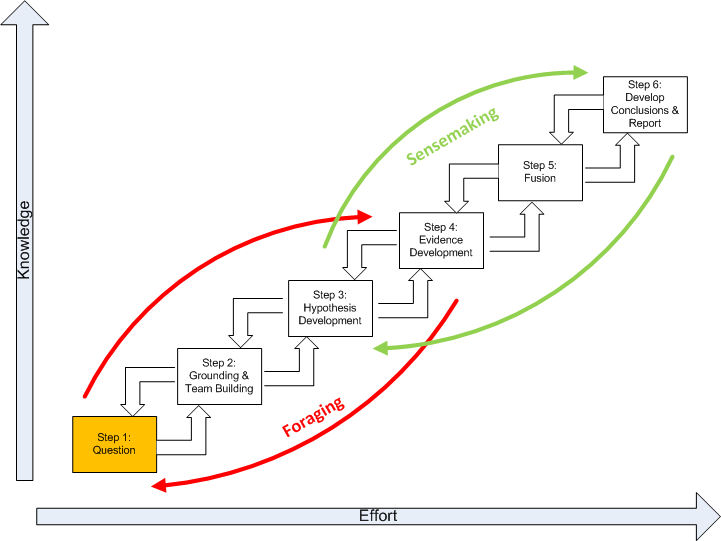
Chapter 4 Overview
This chapter discusses the first step of the SGAM, highlighted below in gold, the Analytic Question.
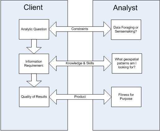
The question, or analytical problem, can be viewed as an active two-way interface between the client requiring the information and the geospatial analyst supplying it. The problem defines the geospatial patterns the analyst is seeking. Foraging and sensemaking define the nature of the analysis and quality in this context defined as satisfying the client. A geospatial question that leads to the sensemaking process must meet three criteria of:
- At least one plausible explanation exists with some geospatial aspect.
- Counter-explanations are possible.
- The hypotheses can be defined sufficiently with respect to the geospatial aspects to allow us to gather evidence.
Therefore, the problem possesses a highly strategic significance. The figure below depicts a three-way connection between the client and analyst’s domain:
Before beginning, ask the following questions:
- Who is the key person for whom the analysis is being completed?
- Do I understand the question? (If necessary, clarify this before proceeding.)
- What is the most important message to give this client?
- How is the client expected to use this information?
- How much time does the client have?
- What format would convey the information most effectively?
- What is the client’s level of tolerance for technical geospatial specific language? How much detail and what geospatial accuracy does the client expect?
- Would the client expect the analyst to reach out to other experts within or outside the Intelligence Community?
- To whom, or to what source, might the client turn for alternative views on this topic? What data or analysis might others provide that could influence how the client reacts to what is being prepared in this paper?
The question focuses the analyst on the nature of the spatial and temporal patterns the analyst is seeking to identify and understand. Many new geospatial analysts struggle to translate the question into the context of spatial concepts. To overcome this, we stress the importance of understanding the general analytical question and developing a spatial corollary of this broader question.
What is an analytic question? There are significant differences between a “factoid question,” which are the most common in Geospatial Intelligence, and an “analytical question.” A factoid question seeks a piece of information that would be answered with a corresponding true statement. For example:
Question: “How many miles are between two shooter events?”
Answer: “There are 5 miles between events."
In general, a factoid question usually has just one correct answer that can be easily judged for its truthfulness. Answers to factoid questions are important as evidence but are not to be the focus of an analytic effort. Data foraging provides factoids (or evidence), a small but potentially important bit of information. In contrast to a factoid question, an analytical question has a less certain relationship with expected answer. For example:
Question: “Who is the DC Shooter?”
Answer: “The shooter could be a foreign terrorist or a serial killer.”
In general, an analytical question has many possibly correct answers that cannot be easily judged for truthfulness. An analytical question is generally quite flexible in the sense that there is always a strong possibility that we may not arrive at the “expected” answer. Thus, a change of analytic strategy, and even the initial expectations of the analysis, may be warranted. This suggests a solution to an analytic question must involve iterative information foraging and sensemaking.
Geospatial Corollary
The Geospatial Corollary is a highly spatial problem statement which follows readily from the broader analytic problem, and suggests a narrowly focused spectrum of geospatial questions. The evidence developed as part of the spatial corollary contributes to the larger body of evidence of the initial analytic problem; the spatial corollary is unlikely to be as significant to the stakeholder as those of initial analytic problem statement. The development of this spatial corollary involves an active two-way discussion between the client requiring the information and the geospatial analyst supplying it. For example, “What geospatial aspects of the events help to explain if the DC Shooter is a foreign terrorist?” The spatial corollary must be “analytic” which means four conditions are met:
- It must be at least one spatial quality or relationship to be explained;
- At least one plausible explanation of the spatial quality or relationship must be posed;
- Counter-explanations are possible and analysis must include an investigation of alternative hypotheses; and
- The hypotheses must be capable of being defined sufficiently to allow us to gather spatial evidence.