A Few Notes on Other Types of Coastal Classifications
A Few Notes on Other Types of Coastal Classifications
What is an emergent coast? How does an emergent coast differ from a submergent coast? What is an erosional coast and how is it different from a depositional coast?
As mentioned at the beginning of this module, there have been a number of coastal classification schemes proposed throughout the time of coastal scientific inquiry. There is not enough room in this module to discuss all of these in detail, but here are a few more as food for thought and discussions that will come later in this course.
Emergent and Submergent Coasts
Emergent and Submergent Coasts
The elevation of sea level has not always been constant. It varies locally on a daily basis because of the phenomenon of tides but has also changed across much longer time periods. For example, about 18,000 years ago, when large ice sheets were present on the planet during a period of cooler climate, sea level was approximately 120 meters lower than it is today because a large volume of ocean water was frozen in ice sheets at that time. In this case, sea level was below the current sea level elevation because of actual volumetric changes to the amount of water stored in the ocean basin.
There are, however, other ways to change the apparent elevation of sea level along a coast. Consider, for example, keeping global sea level steady along an active plate tectonic margin where the coast is being uplifted. Because the land surface is being uplifted, there is an apparent fall of sea level elevation, even though the total volume of water in the ocean basins has not changed. When we can observe evidence of a change in sea level elevation, whether it be an increase or a decrease of elevation, we call it a relative sea level change because we may not necessarily know what mechanism actually contributed to the observed change. You will learn a lot more about changes in sea level later in this course; but, for now, keep in mind that many lines of geologic evidence exist for a long history of relative sea level changes. This leads us to recognize two different types of coasts on the basis of whether they have experienced a relative sea level fall or relative sea level rise.
Emergent Coasts
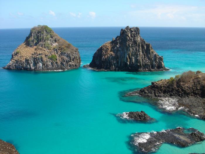
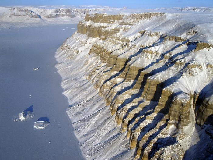
Emergent coasts are a result of local tectonic uplift of the land surface or a fall in the elevation of sea level because of a reduction in the water volume of ocean basins. Quite often, emergent coasts have rocky coastlines with cliffs and nearly flat platforms that extend inland where older coastal plains have been tectonically raised and are now elevated above the modern land and water interface. A very good example of an emergent coastline, because of its proximity to an active plate tectonic margin, is the west coast of North America. Parts of the Scandinavian coastline (Sweden and Norway) are also emergent where the land surface has been rebounding upward due to the removal of the weight of glacial ice that formed during the last Ice Age but has since melted. The images below show typical emergent coastlines.
Submergent Coasts
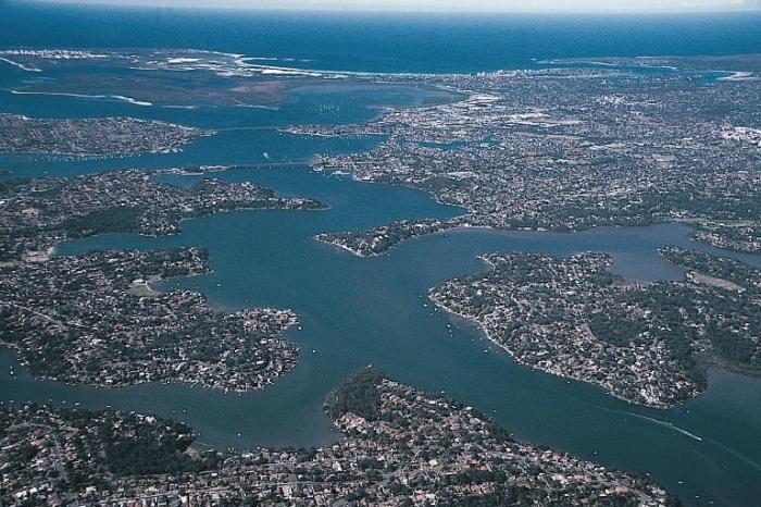
Submergent Coasts are those that have been flooded by ocean waters because of a relative rise in the elevation of sea level at that location. The rise in sea level can be either the result of an increase in the volume of water in the ocean basins or the result of the land surface sinking, both of which create an apparent rise in the elevation of sea level. A common feature of submergent coastal zones is river valleys or glacially-carved valleys that have been flooded by ocean water. The Chesapeake Bay of the eastern United States is a classic example of a river valley that extended to the edge of the continental shelf during the last Ice Age when ocean waters were stored in the ice sheets. As the ice age ended, ice sheets melted, and sea level rose, the river valley was flooded with marine waters to create the Chesapeake Bay. The images below show the Chesapeake Bay as well the spectacular Sydney Harbor, also formed in a drowned river valley.
Erosional and Depositional Coasts
Erosional and Depositional Coasts
Another approach to coastal classification is to consider whether coastal processes in the coastal zone are primarily contributing sediment to the coastline, or whether they are removing sediment from the coastline. The former of these is recognized as deposition, whereas the latter is known as erosion. Where erosion is the dominant process, the coastline is retreating landward, and where deposition is dominant, the coastline is advancing seaward.
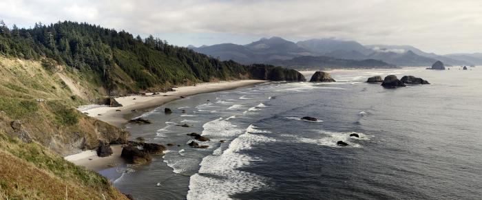
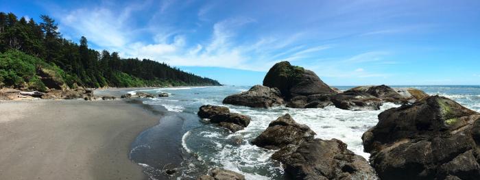
Erosional Coasts
In places where there is an abundance of wave energy or ocean currents and/or a lack of sediment available for deposition, erosion of the coast will be the dominant mechanism of change. Quite often, erosional coasts are narrow and characterized by resilient rocky shorelines that are exposed to high energy waves and supply relatively little sediment to the adjacent shore. This is the case for much of the western U.S. where there are numerous rocky exposures and vertical sea cliffs (see images from Oregon and Washington coasts below). Often, but not necessarily always, erosional coasts are associated with coastal zones along active plate margins where there is a steady uplift of the landform, and few well-developed drainage basins and rivers systems have developed to deliver large quantities of sediment to the coast.
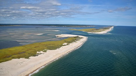
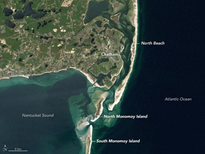
Depositional Coasts
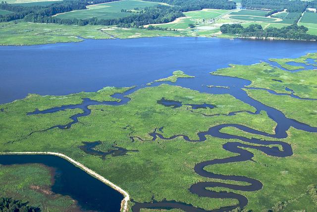
Depositional coasts are characterized by abundant sediment supply that results in the net deposition of sediment and the creation of new coastal landforms despite the energy of the waves and ocean currents. There is a wide variety of landforms along depositional coasts, such as extensive beaches, barrier islands, and expansive coastal wetlands and mudflats (see typical depositional coasts in the images below). They are most common along mature, tectonically inactive continental margins where ample geologic time has passed for large drainage basins and rivers to develop, which can provide large quantities of sediment that can be distributed by waves and tides at the coastline.
Learning Check Point
Learning Check Point
Please take a moment to think about what you have learned in this section, then answer the question below.
There is no credit for this activity, but at this point, you should be able to discuss the characteristics of glaciated coasts, the role of climate in the biological activity and weathering of coasts, as well as the types of storms that can impact coasts.