Early Smart Building
Early Smart Building
The concept of smart building or building with nature is not new. Early settlers, cities, and communities living along river banks, deltas, and along coastlines have adapted their lifestyle to the pulsing and cyclic forces of nature. From fluctuating sea levels to seasonal flooding, to storm flows, these communities slowly built resilience and developed methods to help them withstand the elements to maintain a way of life. Communities were founded or expanded along high ground; evacuated low-lying areas in river valleys during floods; fled during storms, or learned to live with water, often creating floating infrastructures. We will now explore some basic early smart building approaches by visiting low-lying and delta communities in the United States, the Netherlands, and the Mekong Delta in southwestern Vietnam.
The Netherlands - Terp Mounds
The Netherlands - Terp Mounds
Early Dutch Flood Protection
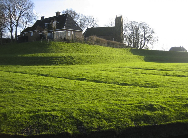
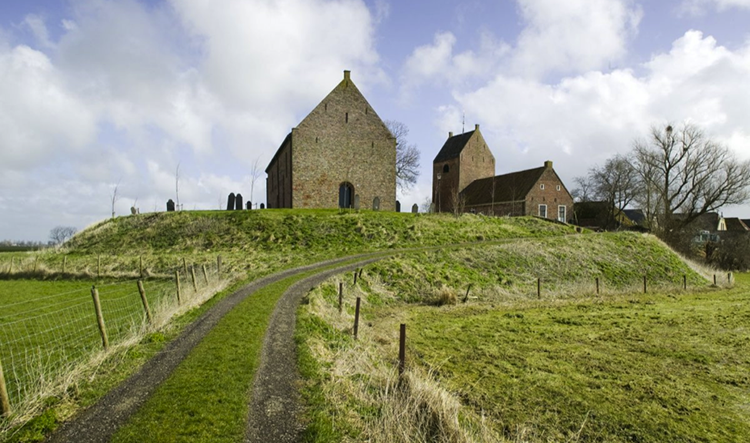
Flood protection in the Netherlands did not begin with dikes, land reclamation, and monumental surge gates. When the ‘low countries’ were first settled in prehistoric times, temporary communities were established on natural beach ridges and dunes, the highest topographic features in the area. The settlements were still at the mercy of nature, and communities retreated or perished when exposed to high storm surges. From around 500 B.C. onward, settlements along the Dutch coast were constructed on terps, or artificial mounds built to above typical high tide and surge levels so that communities would no longer be destroyed by floods. In the Middle Ages, large constructed mounds enabled permanent settlement in the fertile areas near the coast and rivers. During flood periods, villagers along with their livestock would retreat to the central mound with little risk of loss of life or property. Indeed, the floods were beneficial, depositing fine sediment in floodplains that helped improve agriculture. The figures below show two persevered terps in the Friesland province of the Netherlands. The terp mounds were a very resilient system against flood protection. For small village populations, terp-building was a great example of smart building. Important structures, such as dwellings and churches, were sited so that vulnerability to flood hazards was greatly reduced, while agricultural fields that could be flooded without significant damage were allowed to be inundated. With sufficient warning, loss of life and property (including valuable livestock) could be virtually eliminated by taking refuge on the terp, while natural processes that encouraged siltation to counter subsidence were not interrupted.
Mekong Delta - Floating Communities
Mekong Delta - Floating Communities
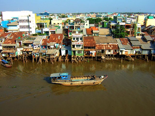
The Mekong Delta in Southern Vietnam is characterized by a vast and fertile flood plain, made possible by the presence of delta distributaries, canal networks, and small villages and houses, an important corridor for biodiversity. The region's tropical climate, with a wet season lasting most of the year, calls for adaptation to the ever-flowing waters of the region. The fertile soils and lack of topographic relief in the lower delta and coastal zone compared to the proximal areas with more relief, produced two distinct types of communities. In the upstream delta regions with more topographic relief, communities are organized into villages with a typical cluster of housing or buildings, while, in the lower delta, communities are not organized into villages. Instead, they are spread throughout the delta, lining the channel banks and waterways that run through the district. This primitive smart building suggests that perhaps the floating or elevated houses are near canals to make more space available for agriculture, but also to provide access to transportation. The canals are the main routes for transport in and out of the district, with boats being the main form of transportation for both people and goods. Secondary transportation routes include elevated narrow roadways that run between rice fields, connected through centralized hubs where pedestrians and bikes can be transported across canals by ferries.

Despite the adaptation of communities to living with water in the Mekong delta, climate change-driven sea level rise, drought, and river floods remain a threat. The Vietnam Ministry of Natural Resources and Environment predicted in 2012 that a 1 m increase in sea level would inundate approximately 39% of the lower Mekong delta basin. The risk to these communities might be even higher if one considers droughts and floods inundating agricultural land, damaging crops, and potentially disrupting the food supply. As a result, the Asian Management and Development Institute is working with coastal provinces of the Mekong on community adaptation programs to better understand and prioritize climate risks and take actions to strengthen their resilience to food and livelihood insecurity resulting from climate change. The adaptation is needed to ensure key income continuity, sustenance food sources generated through rice production, aquaculture (shrimp and clam), livestock rearing (ducks and pigs), and coastal shellfish farming.
New Orleans
New Orleans
Early Smart Building along the banks of the Mississippi River
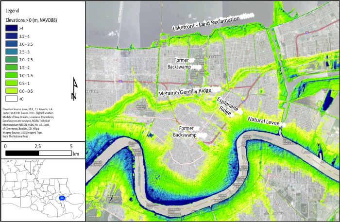
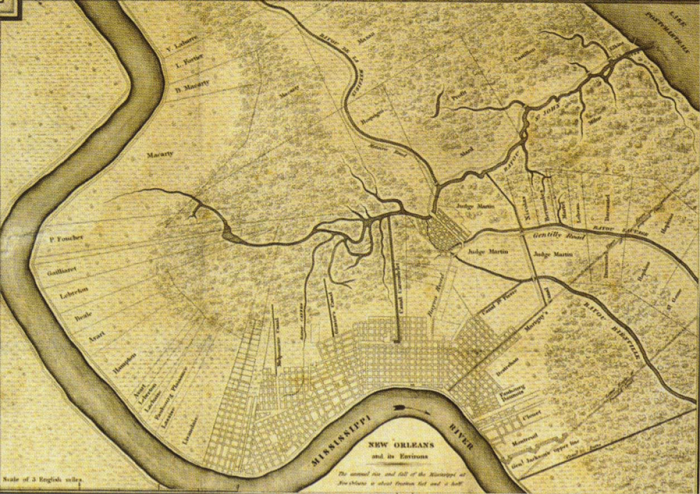
It is a common misconception, widely promulgated during the media’s coverage of Hurricane Katrina, that the city of New Orleans is below sea level. In fact, almost 53% of the city is at or above sea level (Campanella, 2007). Before the construction of flood protection levees along the Mississippi River, seasonal spring floods caused the river to overflow its banks, depositing sediment in the floodplain along both sides of the river. Sediment deposition was most intense directly at the bank and decreased with distance from the river, gradually building up a natural levee elevated above the surrounding land and typical river stages. From the topographic high of the natural levee, the land surface slopes downward to the below sea level backswamp. The natural levee of the Mississippi is visible in the map of above sea level elevations in New Orleans below, following the crescent shape of the river.
Another major above sea level topographic feature in New Orleans is the Metairie/Gentilly Ridge, a single feature that is known by either name depending on which part of the city it traverses. Formed by the natural levees of a relic distributary of the Mississippi River when its mouth was to the east of New Orleans, the ridge sits several feet above sea level and the surrounding lowlands. The Esplanade Ridge, also formed by a small Mississippi River distributary channel, connects the Metairie/Gentilly Ridge to the river’s natural levee. Most other areas in the city above sea level are artificial, the result of land reclamation along the lakefront, dredged material disposal along navigation canals, and construction of flood protection levees.
New Orleans was established as a French colony on a crescent-shaped piece of land between the Mississippi River and Lake Pontchartrain, about 80 km from the river’s mouth. The original settlement was built on high ground adjacent to the river and was bordered by low-lying cypress swamps to the North. A map of the further-developed city in 1829 is given below, with some constructed drainage canals already visible. Note that the city is confined to areas above sea level, the river’s natural levee and a small settlement on the Gentilly Ridge connected to the French Quarter by the Esplanade Ridge.
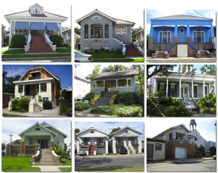
During the city’s early development, historic homes in the area employed a smart building approach despite being built above sea level. Realizing the threats of flooding from both the river and the sea, early New Orleans residents showcase houses that are elevated with elaborate architecture or houses that employ basements that are actually on the first floor. Some examples of these houses are shown below and show how well-prepared the communities were as a result of living with and being surrounded by water.
Due to its unique geography, New Orleans is subject to three types of flood risk: river floods from the Mississippi River, storm surge-induced floods from Lake Pontchartrain and Lake Borgne to the East of the city, and heavy rain-induced flooding due to the low-lying city’s poor drainage. The realization of these threats throughout the city’s history has influenced the development of its flood protection system. From its inception, New Orleans was routinely flooded by the high spring runoff floods of the river. To prevent these floods, the same strategy of heightening the natural overflow banks has been implemented at various scales. Though it did not directly inundate New Orleans, the great Mississippi flood of 1927 resulted in the authorization of the Mississippi Rivers and Tributaries Project, whose construction ensured protection from further river floods. Levees were constructed along most of the lower Mississippi River with 7.5 m above sea level levees fronting the city of New Orleans.