The Need for Growth
The Need for Growth
City Expansion and Smart Considerations
Despite the high risk of exposure to coastal hazards of increasing intensity and frequency, most of the world's populations, economic activities, and infrastructure continue to be located along the coast. In many cases (see Module 9), retreat and abandonment of high-risk areas is simply not an option. Already growing populations, augmented by immigration, in major coastal cities requires thoughtful planning to protect against flooding without hindering the many valuable ecological functions within the coastal zone. The following sections detail several smart building measures that have satisfied the need for growth in coastal zones.
The Netherlands
The Netherlands
The terp mounds were a very resilient system against flood protection. However, the size of the constructed mounds was limited and they could only support small villages. With continued population growth and the need for more protected space in villages, the Dutch began building ring dikes around towns. As settlements continued to expand into the low, coastal areas, the land was drained using increasingly elaborate means (ditches, windmills, steam pumps). This drainage, coupled with peat harvesting and poldering (a method used to reclaim land from the sea), caused extensive subsidence, which increased flooding vulnerability. The increasing populations and value of property inhabiting lowlands required higher and stronger dikes, so much so that now most of the Dutch population and economic activity is supported by areas below sea level that are protected from floods by massive, nearly indestructible dikes and surge barriers. With such high consequences of flooding, dikes, and barrier structures for much of the country are designed to protect against a flood with a 1 in 10,000-year recurrence interval.
Learning Check Point
Objective: Understand the benefits of building with nature, and distinguish smart building approaches.
Although this Learning Check Point is not for credit, you will be expected to understand this material for the Module 10 Quiz.
Watch the required video Protecting Against Flooding: Holland's storm-surge barrier [1] (9:43) about the “Deltaworks” flood protection system in the Netherlands. Answer the questions below.
Amsterdam
Amsterdam
Modern Floating Houses
Driven by a lack of space on land to expand, the proximity of water has driven the concept of a houseboat to extremes in Amsterdam and around the world. Originally docked in canals, houseboats are now taking a new shape. They are redesigned to be just as good, if not better, than their land counterparts, and are taking shape over water. Small communities of floating houses are rapidly evolving, to fill the growing need. Watch the following video to learn more about the new construction of floating houses.
Video: Living on Water: Sustainable Housing in Amsterdam (5:40)
With more than 500 inhabitants per square kilometer, the Netherlands are in the top 5 most densely populated countries in the world. So if we need to allocate more space for service water, why not live on it? This is in line with a dutch planning strategy known as meervoudig ruimtegebruik, multiple use of space. Houseboats became popular in the 1960s and 70s when students could not find affordable housing and squatted on barges instead. Today, there are about 2,500 houseboats moored in Amerstdam waters. Usually, each house is a separate entity, moored to the quay and equipped with its own connections to electricity, water, and sewage.
More recently, though, there are experiments with larger floating settlements. At Haveneiland - West, which belongs to the new IJburg archipelago in the east of Amsterdam, there's a new neighborhood of 34 converted barges. The old ships are up to 42 meters long and are moored at a communal jetty running along the quay. They can be reached via two entrance pavilions above the water, which also house bike garages and letterboxes. It might not look like it from the outside, but each houseboat offers around 200 square meters of living space. Inside, they are unexpectedly bright and spacious. Some interiors have been designed by architects, such as this one by Ana Architecten. It hardly gives away that you're inside the belly of a ship built in 1957.
While the barges still convey the feeling of living on a ship, there's another development just next door at Steigereiland, which strikes a new path. In a locked-off part of the lake, two neighborhoods with floating houses have been realized. The master plan for both was made by architect Marlies Rohmer. The northern part consists of 40 individual floating houses designed by various architects and was realized around 2012. In between the houses, there's not a lot of space, but it's enough to park your boats or even create a little terrace. Some inhabitants have made tiny floating gardens to accompany their floating home. The floating houses have a concrete base that contains a semi-underwater story. The air contained in this tub, lets them float. The lightweight construction on top is made of wood. In total, they offer around 150 square meters of living space.
The other side of the area, Steigereiland - Zuid, was designed as a floating community by architect Marlies Rohmer. The design of the floating houses is based on a modular system with detached houses, duplex houses, and triple houses. In total, there are 55 floating homes, but also three stilted houses, and seventeen dike houses. In social terms, it is a mixed water community with owner-occupied as well as rental houses. Inhabitants can choose from a range of pontoons and terraces as extensions of their homes. Like on the other side of the lake, each house has its own connections to electricity, water, and sewage, hanging in tunnels under the jetties and in plastic tubes under their buildings.
And here is the reason why the envelope of the house is the same on both sides area. They all have to fit through this little lock. The wharf where they were produced lies in a village in the north of Lake Isomer. After construction, the houses were dragged across the lake, maneuvered through the lock, and then moored in their final location.
The latest floating development in Amsterdam takes the story one step further. Schoonschip is a community with 30 water plots in a canal. The urban plan was developed by the architecture firm Space & Matter but within the plan, each house was designed individually. Schoonschip has the aim to be a resilient and entirely circular development. That's why all the floating homes have solar panels on the roof, generate energy with heat pumps, and store it in in-house batteries. There's only one connection to the national energy grid. Thanks to a smart grid, inhabitants can trade energy that they generate amongst each other. Wastewater from toilets and showers is treated and also converted into energy. Inhabitants don't own cars, but share a pool of electric cars and cargo bikes. These floating houses work exactly like the ones on Steigereiland, and they are also moored at jetties. But you can see there is a lot more wood used here. For the jetties, as well as for the facades. And there is another important difference to earlier projects. This neighborhood, home to 48 families, was a result of a bottom-up initiative and participation process. That's why there's a strong community feel, also expressed in the wide jetties, which serve as communal exterior space. Schoonschip is the most recent and most sustainable floating development in the Netherlands. It probably won't be the last, considering the challenges of climate change in a country that lies largely below sea level, and suffers from increasing rainfall. It is also another manifestation of the paradigm shift from fighting against water to living with water and enjoying it.
Greater New Orleans
Greater New Orleans
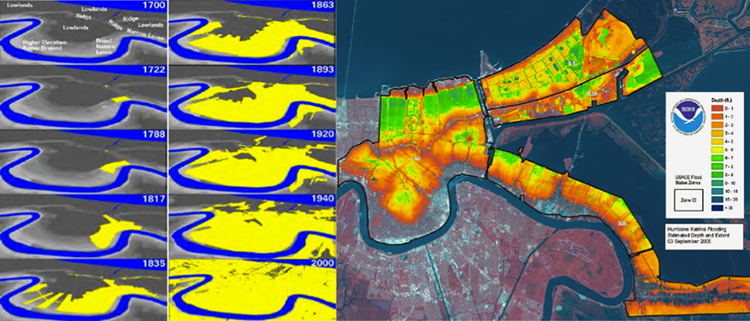
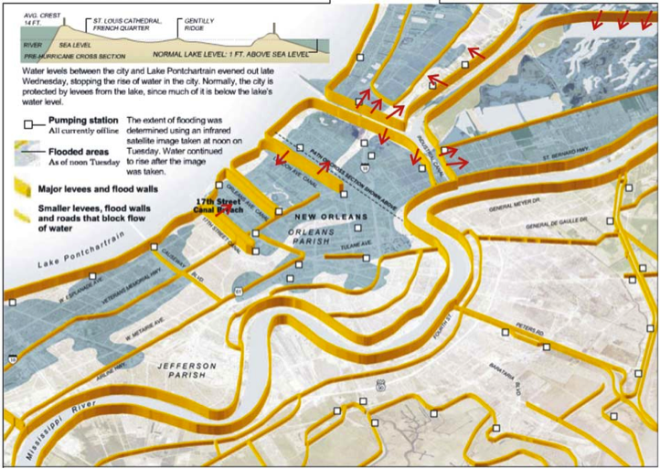
The city of New Orleans' expansion was partially driven by the need for space (to expand) and the unavailability of sufficient space above sea level. Driven partially by flood protection measures due to the Mississippi River and Tributaries Project, the city expanded into the former back-swamp north of its original footprint. Small-scale levees, termed drainage levees, were constructed on the South shore of Lake Pontchartrain and drainage canals were dredged so that floodwaters could be conveyed out to the lake. To facilitate drainage from an area that is shaped like a bowl (recall Digital Elevation map earlier), an elaborate system of pumping stations, in conjunction with the levees, had to be built. Despite these improvements, the city was still frequently flooded by hurricane-induced storm surge, including major floods in 1947 and 1965. These events, and particularly Hurricane Betsy in 1965, resulted in the inception of another federal project, where the Lake Pontchartrain levees were raised to the current elevation. But the lack of space to construct strong earthen levees, such as those that line up the Mississippi River banks, called for a hybrid construction method. This included the addition of sheet pile walls added atop the existing drainage canal levees, forming the foundation for the concrete floodwalls. These structures failed catastrophically during Hurricane Katrina. The figure below gives a typical cross-section of the city, stretching from the river on the left to the lake on the right.
Was the catastrophic flooding from Hurricane Katrina due to false protection and unknown risk? To partially answer the above question, we examine city urbanization patterns with the city topography and flood depths from the widespread event that provided the only data point for flooding post-1965. Historically, and to accommodate the growing population of the city, settlement expanded from the crescent-shaped high ground that was organized along the natural levees of the Mississippi River into the former backswamp areas. This expansion would not have been possible without the development of cutting-edge pumping technologies coupled with an elaborate and challenging levee building construction. These technologies first enabled the swamps to be drained, promoted development to extend into these low areas, and helped keep the city drained during heavy rainfall. But, the modifications that took place post-1965 were proven to be the most vulnerable and were not really tested until decades later. While still not immune to flooding risks, areas above sea level in the original city plan were significantly less vulnerable and fared relatively well during Katrina. Recall the DEM at the beginning of the module, and now examine the figure below. From the figure to the left, it can be seen that New Orleans did not expand significantly into low-elevation areas until the late 19th century, exposing the population in the newly-settled areas to elevated flood risks. Up until this point, the settlement patterns of the city clearly followed smart building principles, where development was generally limited to the higher elevations of the natural levees and relic distributary ridges. False protection, afforded by the levees and an elaborate pumping system, produced peace of mind but without contingency or layered defense concept/approach, and resulted in catastrophic flooding when the levees failed.