Second Order Influence on Coastal Zones
Second Order Influence on Coastal Zones
On the basis of the information discussed in the last several sections, it should now be evident to you that that plate tectonics has a strong influence on the characteristics of continental margins and the associated coastal zones. There are, however, several other key secondary influences that also affect how coastal zones evolve. These include:
- sediment supply,
- glaciations (direct and indirect),
- climate,
- hydrographic regime.
Each of these will be discussed individually in the following sections to provide a comprehensive framework of the types of processes that need to be considered when attempting to evaluate coastal characteristics and evolution.
Sediment Supply
Sediment Supply
How is sediment supply related to the tectonic setting of a coastal zone?
The availability and transport of sediment, loose non-cohesive material, within the coastal zone strongly affect the morphology of a coastal zone. Additionally, it turns out that sediment supply to a coastal region is very closely linked to the tectonic setting of the coastal zone.
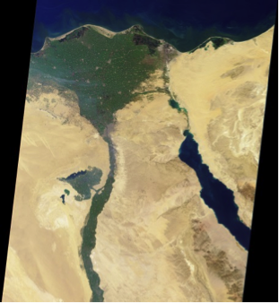
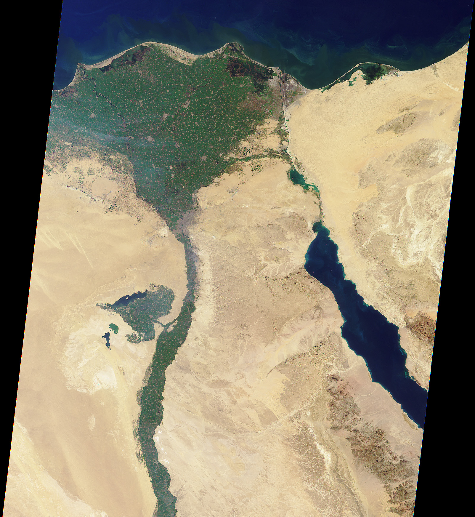
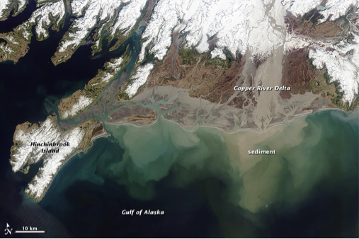
To understand this better, let us take a look at Afro-Trailing and Amero-Trailing Edge Coasts. Along Afro-Trailing Edge Coasts, relatively little sediment is delivered to the coast when compared to the amount of sediment that is deposited along the Amero-Trailing Edge Coasts. Recall that a characteristic of Amero-Trailing Edge Coasts is large mountain systems inland of the coastal zone and on the opposite side of the continent. These uplifted mountain systems provide a ready source of sediment that can be transported by river systems to the tectonically inactive Amero-Trailing edge of the continent. The opposite side of the continent from an Afro-Trailing Edge coast, however, also has a trailing edge and no substantial uplifted mountainous areas that can supply sediment. The east coast of North America is a somewhat special case because it was once a collision coast, and, therefore, it is drawing sediments from the Appalachian Mountains which were formed during a geologically much older tectonic collision between North America and North Africa.
To put this in context, examine the drainage basin of the Amazon River on the maps below. The Amazon basin extends all the way from the western collisional margin of South America where the Andes Mountains are located to the trailing passive margin of the east coast of South America. The Andes Mountains are geologically young and are the result of tectonic uplift associated with subduction. Because of their elevation and size, they provide a large amount of sediment to the Amazon drainage basin that can be carried by the Amazon River to the Atlantic Ocean. Alternatively, the Niger River on the west coast of Africa has its headwaters in low-lying, (compared to the Andes mountains) very old rocks that provide little loose sediment to the river. As a result, the Niger River carries approximately two orders of magnitude less sediment to the ocean than does the Amazon River (Table 2.1).
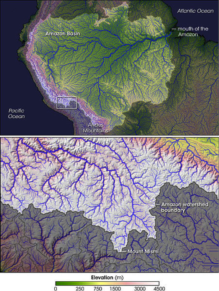
| Type | River | Sediment Discharge |
|---|---|---|
| Amero-Type | Amazon River | 2000 x 106 tons yr |
| Afro-Type | Niger River | 20 x 106 tons yr |
Glaciations
Glaciations
What are the direct and indirect effects of glaciations on coastal zones?
Glaciated Coasts
The effects of glacial activity along coastal zones can be broadly broken into two categories. Direct effects would include the shaping of coastal zones in high latitude areas toward the north and south poles of the planet, where glacial ice is in direct contact with the land surface. Indirect effects would include low latitude areas toward the Equator where glacial ice is not a permanent feature in coastal zones.
Direct Effects on Coasts by Glaciation
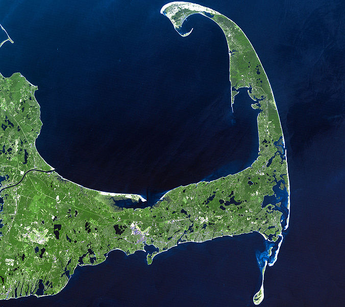
The New England states of northeastern United States are a good example of where glacial ice has had a direct and obvious impact on the coastal morphology – specifically along the coast of the state of Massachusetts and around the city of Boston. Between approximately 100,000 and 18,000 years ago, a large percentage of the North American continent was covered in a several kilometers thick sheet of ice that progressively advanced southward during this time. As this massive ice sheet advanced, it scoured and scraped the underlying ground. The scoured sediment was transported as the ice sheet advanced into progressively lower latitudes. Sediment was also carried by meltwater streams that existed out in front of the ice sheet. The result is that glaciers and ice sheets such as this can move substantial amounts of sediment and act to create a unique suite of glacial landforms such as terminal moraines and outwash deposits. In fact, it is these types of deposits that formed the surface sediments of famous New England places such as Cape Cod, Martha’s Vineyard, and Nantucket.
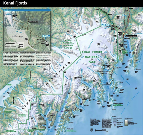
Another type of direct effect that ice sheets and glaciers can have along the coast does not involve the deposition of sediment, but rather the erosion of sediment and the creation of features such as valleys. On a global basis, the modern-day fjords were created during the most recent global-wide glacial event that led to the advance and growth of ice sheets and mountain glaciers everywhere. It was during this period of time that the ice carved out what would later become known as fjords. Since 18,000 years ago, ice sheets and glaciers have been melting worldwide, and this extra water in the ocean basins has led to a rise in sea level and flooding of the glacially carved valleys. In fact, famous fjords of places such as Alaska, Chile, and Norway are the direct result of glaciers once extending to the sea from high areas, carving very long and often deep but generally narrow valleys.

Indirect Effects on Coasts by Glaciation
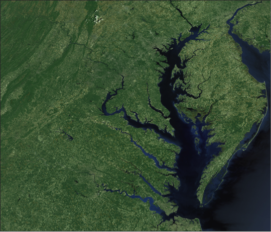
The indirect effects of glaciations are considered to be associated with the lowering of sea level during the last Ice Age and the subsequent rise of sea level that coincided with the melting of the ice-age ice sheets and glaciers. During the period of major ice sheet and glacial expansion, sea level was approximately 120 meters lower than it currently is today. During this period of lowered sea level, rivers systems on a global extent would have extended across the continental shelves, which were subaerially exposed because of the lowered sea level. River valleys cut across the continental shelves as rivers flowed to reach the new elevation of sea level. The valleys were progressively widened and deepened, and during deglaciation melt, water was released back into the ocean basins and sea level progressively rose so that the river valleys became inundated. This indirect process of glacial and ice sheet influence on the coastal zone is evident in the Chesapeake Bay of the eastern United States. The Chesapeake Bay, as well as many other drowned river valleys, provide critical habitat for freshwater, brackish, and marine water species of plants and animals, but are becoming a progressively more endangered habitat because of the influx of agricultural nutrients through runoff and discharge of wastewater into these environments.
For more information on glaciers and ice sheets, check out these links:
Climate
Climate
The climate of a particular coastal area plays a significant role with regard to the biological activity, weathering, and severity of storms that can impact the coast. Read on to learn about the way these factors influence coastlines.
Biological Activity
Biological Activity
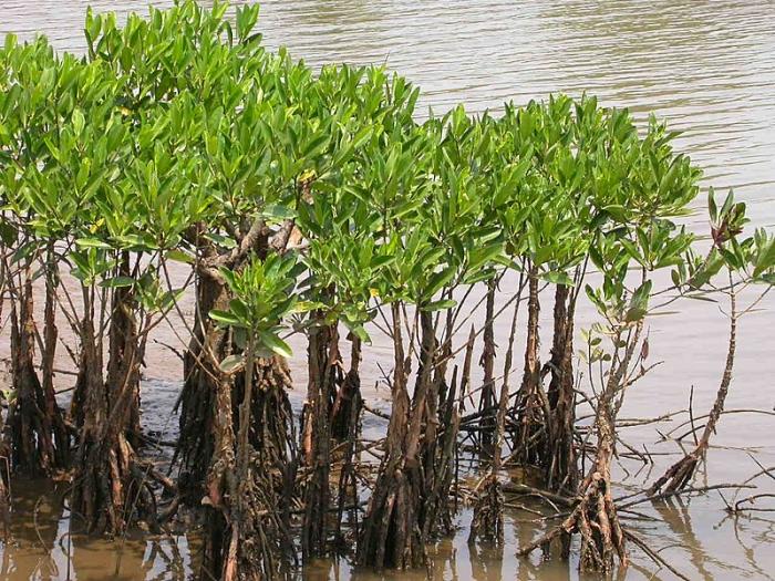
Warm, low-latitude climates encourage the growth of lush vegetation in comparison to relatively colder, high latitude climates. For example, in warm coastal climates, thick, extensive platforms of mangrove forests or salt-tolerant grasses can develop if the substrate is suitable for the development of good root zones, and the plants are not exposed to high-energy waves or tidal conditions that can uproot them. Although a wide range of coastal plant species exists even within high-latitude coasts, the species that occupy warm climates will tend to be more organically productive with longer growing seasons.
Along coasts where vegetation is highly productive, this vegetation can constitute a significant contributor to the coastal sediment budget. When plants of the coastal zone die, the fragments of the plant, also known as organic detritus, can accumulate and help incrementally add elevation to the land surface. In some coastal areas, this process of accumulating organic debris derived from the plants has been suggested to be a major contributor to the health of coastal marshes and their ability to maintain a suitable elevation above sea level as sea level rises.
Vegetation plays another important role along some coasts because extensive root systems help to stabilize environments such as coastal marshes and dunes and can reduce the amount of wave and wind erosion that can take place. The presence of extensive coastal plant communities also can help reduce the destructive power of storm surges and tsunamis to inland areas and coastal infrastructure because the plants act to buffer the energy of these phenomena to the more inland areas.
Some coasts are also fringed by coral reefs. The most extensive and largest reefs are located in warm ocean waters because corals are temperature-dependent, with optimal growth of most coral reefs taking place in low-latitude climates where ocean waters are warm. Corals produce their hard structure out of the mineral calcium carbonate, as do shelled organisms such as clams, oysters, and snails. All of these organisms can be broken apart or fragmented by marine currents and ultimately contribute sediment to a coast. In some areas of the world, the beaches wholly consist of broken coral and shells.

Weathering
Weathering
Weathering is a term that is used to describe the breakdown of solid rock into particles of sediment such as boulders, sand, silt, and mud, as well as ions that are dissolved in water. Two types of weathering processes are recognized: physical weathering and chemical weathering. Physical weathering refers specifically to the reduction of a volume of rock and or individual particles of sediment into progressively smaller and smaller sedimentary particles through mechanical processes. These mechanical processes include fracturing and disintegration by freezing and thawing, transport by glaciers, or even rolling along a shoreline by waves. Chemical weathering, on the other hand, refers to the chemical breakdown of minerals in rocks and the production of new minerals from the dissolved ions. Most chemical reactions proceed fastest when temperatures are elevated and also when there is an abundance of water. In warm wet climates, chemical weathering proceeds fastest, so one would expect that the same rock would chemically weather much faster in a tropical rain forest rather than on an arctic tundra. It is also important to note that because of the nature of chemical reactions in warm, humid climates, there is a more significant production of very fine sediment.
Recommended reading for weathering
- Wikipedia article: Weathering [14]: This article gives an explanation of chemical weathering.
- Watch an informative video on chemical weathering.
Video: Chemical Weathering-Hommocks Earth Science Department (4:04)
Storms
Storms
Large storms in coastal settings typically produce strong winds that can create larger than normal waves. Increased wave heights, and thus the energy associated with the waves, can very quickly change the overall morphology of coastal environments that are exposed to the storm. Even relatively smaller-scale storms, such as thunderstorms, can, with strong enough winds, create substantial changes to a beach or other environments within the coastal zone if they occur with a high frequency during the course of several days or weeks.
Wind can also modify coastal environments. For example, strong winds steadily blowing across a fine-grained beach and dune system for several days can lead to the transport of some of that sand from the beach and dunes and its deposition elsewhere. As a result, environments exposed to strong winds during the course of several days can be reduced in elevation through a process known as deflation.
There is a wide range of scale when it comes to discussing storms. Although capable of inducing change, it is not the random small-scale thunderstorm or even weeks of continuous thunderstorms that cause the most modification to coasts. The most powerful storms to potentially impact a coast are tropical cyclones. We will introduce these systems in the following, but also exploring them in more depth in Modules 5 and 6.
Tropical Cyclones
Tropical cyclones are low-pressure rotating weather systems that are created in the atmosphere by the transfer of heat from the ocean basins to the atmosphere. These low latitude systems (23.5 N and S of the equator) spin clockwise in the Southern Hemisphere and counterclockwise in the Northern Hemisphere and are referred to by different names depending on the ocean basin. In the Atlantic Ocean, they are known as tropical storms and hurricanes when the wind speed exceeds 119 km/hr (75 miles/hr), whereas, in the western Pacific Ocean, they are referred to as tropical cyclones and typhoons respectively. In both cases, tropical cyclones have the capability to generate very large, high, waves that have the potential to devastate the natural environments of a coastal zone and any human infrastructure that is present where the storms make landfall. Another critically important component to understand about tropical cyclones is the storm surges, or elevated levels of sea level, that occur as these low-pressure systems move through an ocean basin. Very large storm surges can be created depending upon the morphology of the coast, the gradient and width of the neighboring continental shelf, the strength of the storm, and the rate of forward motion of the storm. For example, a storm surge in excess of 7 m (25 feet) was created along parts of the northern Gulf of Mexico shore by Hurricane Katrina in 2005 and resulted in inland flooding several kilometers from the non-storm-surge shoreline. We will explore these systems in detail in Modules 5 and 6.
Extratropical Storms and Fronts
North of the Tropic of Cancer (23.5 N latitude) and south of the Tropic of Capricorn (23.5 S latitude), extratropical storms and weather fronts dominate as the major storm impact to coastal zones in these regions. Although not capable of packing the full magnitude of punch that a hurricane can produce, some storms outside of the tropics can produce wind speeds equivalent to those of weak hurricanes, resulting in very large waves and storm surges along coastal environments.
Northeasters
Along the east coast of North America, the classic example of an extratropical storm system is the Northeaster, which is a storm that tracks from the Midwest of the United States, northeast along the east coast of the United States and into Maritime Canada before being turned eastward into the northern Atlantic basin. The term Northeaster derives from the fact that the winds of these storms are from the northeast within this irregularly shaped but counterclockwise rotating storm system. They occur between late fall through spring when cold arctic air moving southeast comes in contact with warmer air moving north from more southerly latitudes to create a low-pressure system with a cold center (in contrast to a hurricane with a warm center). Although not as strong as hurricanes, northeasters are larger in diameter and can impact three to four times as much shoreline as a very large hurricane. Further, their frequency of occurrence is higher for the east coast of North America with 20 to 40 annually, although only several of these generate severe offshore wave heights greater than 5 meters (16 feet).
Recommended reading for Northeasters
- Wikipedia article: Nor'easter formation: [15] This article provides details of Nor'easter formation.
- USGS article on Northeasters [16]: This article provides a brief description of northeasters.
Fronts
There are numerous other types of weather systems that can affect coastal zones. The most common along the northern Gulf of Mexico is what is known as a front. A front is a zone between two air masses with different temperatures, different levels of humidity, and densities. In the winter, low humidity cold air systems sweep southward across North America and encounter more humid, warmer air over the Gulf of Mexico. A strong southerly flow (winds blowing from south to north) persists along the northern Gulf in the days prior to the arrival of the cold front. These sustained winds blow as much as 30 to 50 km/hr and can generate large waves in the Gulf of Mexico that then travel northward and impact the shore, leading to erosion, deposition, and overall modification of the pre-frontal morphology. As the front passes, the wind direction shifts to blowing from the north, bringing much colder and dryer air. These north winds can similarly reach sustained speeds in excess of 30 km/hr persisting for a couple of days. Because these winds are from the north, they can generate large waves in the bays on the north side of the shorelines and have been shown to be very effective at eroding the marsh and other features on the north-facing shorelines of barrier islands and marsh platforms.
Hydrographic Regime
Hydrographic Regime
What does it mean to discuss the hydrographic regime of a coastal zone?
What variability exists in the range of tides and the amount of wave energy for different coastal zones?
Hydrographic Regime is a term that is used to describe the relative influence that waves and tides have along coasts, particularly coasts where the deposition of sediment is more dominant than erosion and removal of sediment. This is because waves and tidal currents are responsible for the movement of sediment along depositional coasts and, ultimately, the relative magnitude of these parameters dictates the type of coastal morphology that will develop. In a discussion of hydrographic regime, there are two primary things to consider, waves and tides. The following sections provide a brief background on each of these phenomena.
Waves
Waves
A full description of waves is beyond the objectives of this course, but very rigorous and sometimes complex theories and mathematical models have been developed to explain waves in water. It also turns out that no singular theory or mathematical model adequately describes the full range of waves and wave behavior within water bodies. An equation that perhaps quite adequately describes wave behavior in deep water might be completely useless when attempting to quantify the behavior of shallow-water waves. Because waves are the most common energy source along most coastal zones, understanding them is paramount to understanding how coasts evolve through time.
Fundamentally, a wave can be considered to be a disturbance of the water as energy is passing through the water. In open ocean basins, wind is the source of this energy that is transferred to the body of water as the wind blows across it. Consider what happens when you blow on the surface of a cup of hot tea or coffee to cool it down, the energy of your moving breath is transferred to the surface of the tea or coffee and causes small ripples or waves to develop.
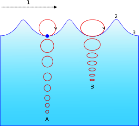
The characteristics of waves are geometrically described by several different parameters including the: 1) wave height or amplitude, 2) wave length, and 3) wave period. As the name implies, the wave height is the vertical distance between the trough of a wave and the top or crest of a wave. Wave length refers to the horizontal distance between successive wave crests or troughs, and the wave period refers to the number of waves that pass a set point within an established period of time (Fig. 2.27).
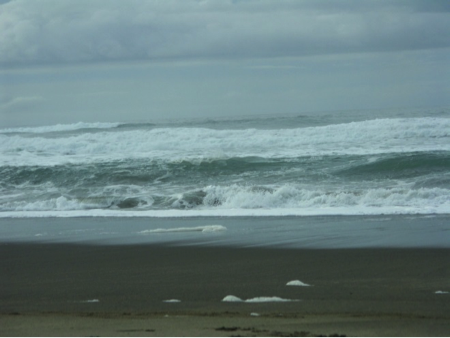
Overall, the height, length, and period of a wave fundamentally are governed by 1) wind speed, 2) the duration of time that the wind has been blowing, and 3) the fetch or distance across open water that the wind has traveled. Wave height and the steepness of the wave increase through time as the amount of energy transferred from the wind to the water increases. For example, an increase in wind speed will cause more energy to be imparted to the water, and the result is that the wave heights correspondingly increase. A wind-generated wave can however not grow indefinitely in the open ocean; at some point, waves will grow so large that they break, and this is how whitecaps are generated.
Waves have the ability to travel great distances in the open ocean, and some studies have been able to track waves more than 10,000 km in the open ocean after many days of traveling. Importantly, one should keep in mind that the water of the waves does not actually travel with the wave but rather the waveform itself does. Fundamental to this fact is the process of circular orbital motion, wherein the energy of the wave is passed along as individual water particles move in a circle below the water surface. These circles of travel, or orbitals, are stacked on top of one another with the largest orbital diameter at the top and the smallest orbital diameter at the bottom. The diameter of the orbitals becomes negligible at a water depth that is equal to half of the wavelength, and this water depth is known as the wave base of the wave. In water depths that are less than half the wavelength, the orbitals become deformed and progressively evolve from being perfectly circular to elliptical. The speed of the wave decreases towards the coast but other waves moving in behind are still traveling at a speed that was equal to the first wave's speed before it began to slow down. All of the waves, therefore, begin to get crowded together and the height and the steepness of the waves increase. Eventually, the waves become unstable because they are too high relative to the water depth, the front of the wave collapses and the wave breaks onto the coastline to create surf (Fig. 2.28). The energy of the traveling wave is then transferred onto the shoreline either carrying sediment up onto a coastal environment such as a beach or removing sediment and transporting it offshore or alongshore.
Longshore Currents
Very rarely do wave trains approach a shoreline aligned perfectly parallel to the trend of the shoreline. It is much more common for wave trains to arrive at an angle to the trend of the shoreline. The net result of waves breaking at an angle to shoreline is to produce a weak current known as a longshore current (LSC). This current flows parallel to the shoreline. Some of you may perhaps recall swimming in the ocean when the waves were relatively large, and where you entered the water was not where you got out of the water. The reason for this is that the longshore current moved you slowly down the beach. This same wave-induced current, in conjunction with sand being suspended by breaking waves, is responsible for moving sand along the beach (Fig. 2.29). For this reason, beaches have sometimes been referred to as rivers of sand, because there is constant sediment transport as a result of longshore currents. The movement of sand parallel to the trend of the shore results in the development of features you will learn about in the next module such as spits; it can also increase the length of barrier islands and the buildup of sand next to coastal structures such as groins and jetties that you will learn about in Module 8.
Tides
Tides
People have been fascinated with tides throughout history, with various aboriginal legends dating back tens of thousands of years accounting for this phenomenon. One Native American legend tells of a raven who wanted to alter the depth of the oceans to make it shallower and therefore make more food accessible for his people, while Australian Aborigines have legends that speak of the moon filling with water while it was waxing, and how water drained back out of the moon as it waned, demonstrating the understanding that the lunar cycle was associated with water levels of the ocean.
Our current understanding of the tides can be explained using Sir Isaac Newton’s universal law of gravitation. He proved that the gravitational attraction between two bodies is directly proportional to mass and inversely proportional to the square of the distance between them. This is the case with the relationship between the sun, the moon, and the Earth. While the moon is relatively small, it is also relatively close to Earth and exerts a gravitational pull on the Earth’s surface that is stronger than that of the sun, which is much larger but also much further away. It is this gravitational attraction of both the moon and the sun to the Earth that causes the periodic rising and falling of the ocean’s surface that we call tides.
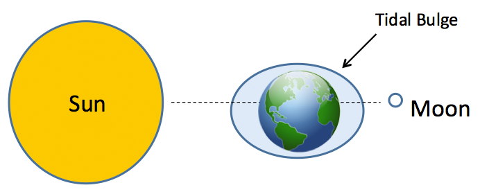
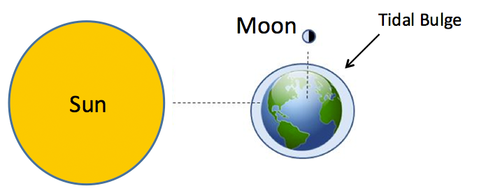
Tidal “Bulge”
The gravitational attraction between the moon and the Earth causes the water in the oceans, which is fluid and mobile, to be pulled towards the moon. This creates a “bulge” in the ocean that is closest to the moon and as the Earth rotates, the location of the waters that are affected, change. Picture the moon as a magnet that draws the water towards it. This movement of water towards the moon is counteracted by the force of inertia, the force that tends to cause a moving object to continue moving in a straight line. This is what balances out the movement of our oceans, but because the gravitational pull is stronger, the resultant force causes our tides. The sun also has this effect, but due to the vast distance from Earth, plays a smaller role.
Spring and Neap Tides
We sometimes hear on the news during a coastal storm that the effects on the shoreline will be more severe due to especially high tides. This is due to the position of the moon and the sun in relation to the Earth and the resulting gravitational attraction at various stages in the lunar cycle.
When the moon is in a position relative to the Earth where it is pulling in a direction that is in the same axis as the sun (new and full moon), both bodies are exerting a force on the Earth that is cumulative. This is called conjunction, and because these forces are both working to pull the Earth’s surface in the same directional axis, we experience higher high tides and lower low tides than we see throughout the month at a given location. This is the period during the lunar cycle that we experience spring tides.
When the moon is in a position that is at right angles to the sun, the gravitational pull of the two bodies is working in opposing directions on the Earth’s surface. This is when the gravitational forces of the sun and the moon are working against each other and we experience moderate changes in water levels. We refer to this period in the lunar cycle as neap tides that occur during quarter moons.
The difference during spring and neap tides is evident in the tide graphs for a tidal gauge in Halifax Harbour shown for Spring tide and Neap tide. This tide gauge is measuring water levels at the same location. However, during a spring tide the high water is almost 6.5 ft while during the neap tide, the high water is approximately 4.8 ft. The low tide during the spring tide is 0.2 ft and during the neap tide is 1.5 ft. The highs and lows during the full or new moon are much more pronounced than they are during the quarter moons. That is why a storm event paired with a spring tide may cause more serious damage along a coastline than a storm event paired with a neap tide.
Tidal Graphs
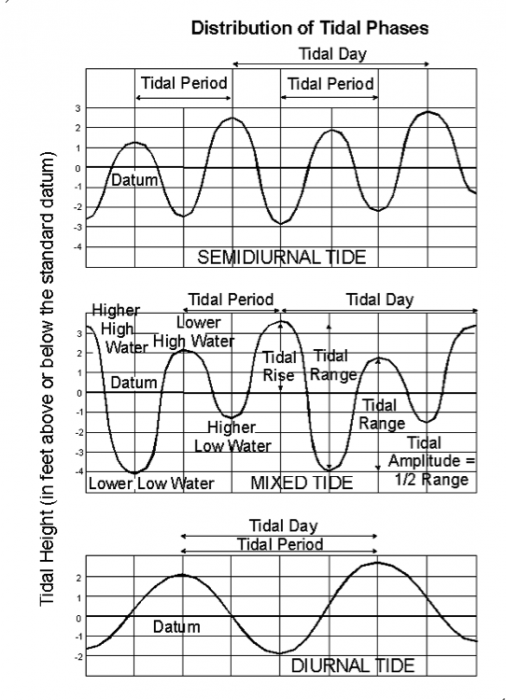
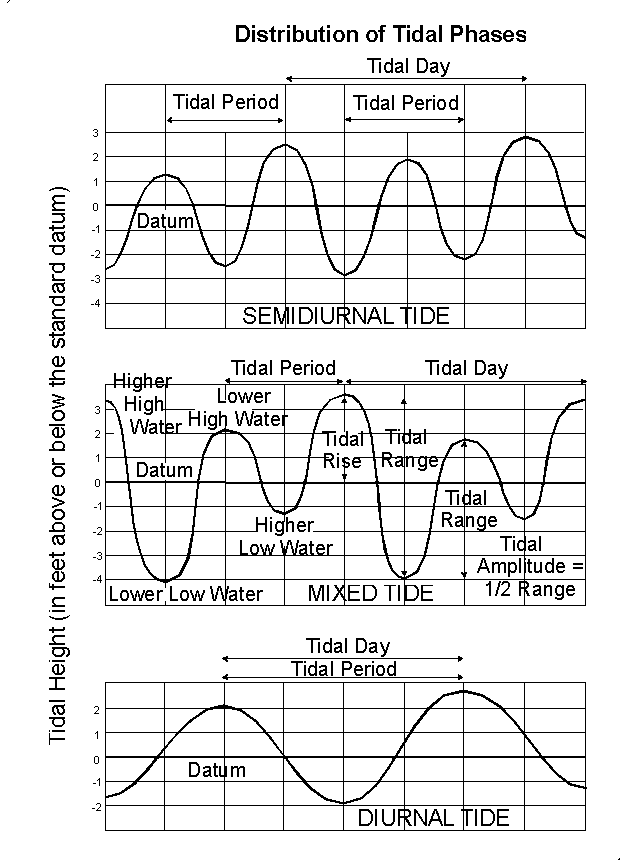
Tidal Cycles
A tidal cycle is one high tide plus a successive low tide. Due to land masses, the movement of water moving around on the Earth's surface due to tides is impeded. The resulting tidal cycle or pattern, therefore, depends on geographic location. There are three basic types of tidal cycles that are globally distributed.
Semi-diurnal Tides
This is the most common tidal pattern, featuring two highs and two lows each day, with minimal variation in the height of successive high or low waters, and is very common along much of the east coast of North America.
Diurnal Tides
There is only a single high and a single low during each tidal day; successive high and low waters do not vary by a great deal. Such tides occur, for example, in the Gulf of Mexico, the Java Sea, and in the Tonkin Gulf.
Mixed Tides
These are characterized by wide variation in heights of successive high and low waters, and by longer tide cycles than those of the semidiurnal cycle. Such tides occur, for example, along the U.S. Pacific coast and many Pacific islands.
Semidiurnal Tide
Tidal period: Time between high tide peak (lower) to high tide peak (higher) or low tide trough (lower) to low tide trough (higher).
Tidal day: Time between higher high tide peak to higher high tide peak.
Mixed Tide
Tidal period: time going through the peak of lower high water, higher low water, and the peak higher high water.
Tidal day: From the peak of higher high water, to lower low water to lower high water to higher low water back to the peak of higher high water.
Diurnal tide
Tidal period=tidal day: between the peaks of high tide

Summary of Waves and Tides
Summary of Waves and Tides
In summary, waves and tides can have a profound influence on the morphology and evolution of a coast. In areas with large waves and thus high wave energy, sediments can be extensively reworked by the erosive energy of the waves and widely distributed by the process of longshore transport. In high-energy coastal areas with strong tidal currents, large volumes of sediment can be transported or reworked by the tidal currents to create deposits that are aligned perpendicular to the coastline but parallel to the flow direction of rising and falling tides. In coastal areas that have large tidal ranges or are low gradient, some parts of the shoreline may be exposed for several hours each day before the next rise in tide, and extensive mudflats can develop for very large horizontal distances.
For more information on tides and waves:
- NOAA movie that discusses wave formation [23]
- Wikipedia website with a discussion of tidal range [24]
- Wikipedia website with a discussion of longshore transport [25]
Video: Longshore Transport (2:19) (Video is not narrated.)
Wave, Mixed Energy, and Tide Dominated Hydrographic Regimes
Wave, Mixed Energy, and Tide Dominated Hydrographic Regimes
Our understanding of waves and tides now sets the stage for a more thorough understanding of how they interact to shape a coastal zone. In the context of the hydrographic regime, there are two fundamental things that must be considered: the wave and tidal energy of a coast.
- Wave energy (E) is a function of wave height (H) with the energy (E) of a wave approximately equal to the square of the wave height (H2).
- Tidal energy can be equated with tidal range because it is the rise and fall of the tides that produce tidal currents. Tidal range (TR) is the vertical difference between high and low tides, which are commonly categorized into three ranges:
Microtidal: TR < 2.0 m
Mesotidal: 2.0 m < TR < 4.0 m
Macrotidal: TR > 4.0 m
The relative dominance of wave versus tidal energy dictates coastal morphology, and three general regimes exist along depositional coasts:
- Wave Dominated Coasts
- Mixed Energy Coasts
- Tide-dominated Coasts
Wave Dominated Coasts
Along wave-dominated coasts, the role of the waves and, thus, longshore transport processes is the dominant factor controlling the coastal morphology. Because longshore transport carries sediment along the shore, these types of coasts tend to have long linear barrier islands and beaches with relatively few inlets or passes between the open ocean and the more interior bays and waterways. The reason for this is that the longshore transported sediment tends to fill in these inlets and passes. Since the tidal currents are relatively weak, there is no energy available to keep the inlets open as a connection between the open ocean and interior waterways.
Mixed Energy Coasts
Mixed energy coasts are a product of both wave and tidal processes and neither process exerts an excessive influence on the coastal morphology, although some mixed energy coasts show tidal or wave dominance. Rarely in nature are processes in equilibrium. These types of coasts typically contain short stubby barrier islands, have numerous tidal inlets and passes, and are separated from a mainland by extensive marshes and an array of tidal creeks.
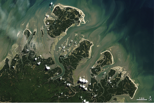
Tide Dominated Coasts
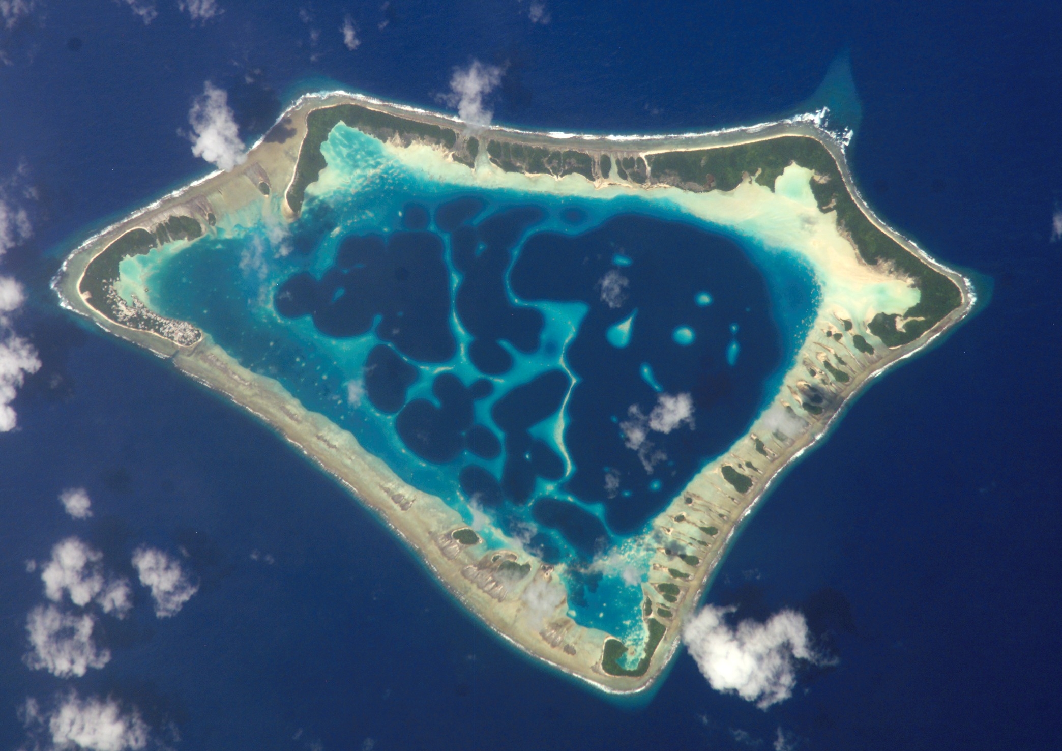
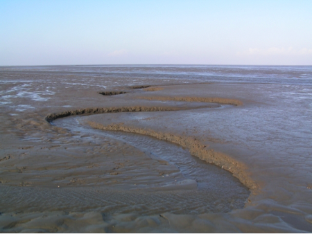
Tide dominated coasts are those where strong tidal currents act to redistribute sediment along the vector of falling and rising tidal currents, which are orientated perpendicular to the trend of the coastline. Quite often, the highest energy tidal currents develop in locations where large tidal ranges are present in conjunction with a shoreline morphology that accentuates tidal flow by constricting tidal currents into funnel-shaped embayments. Sediment is reworked by the resulting tidal currents to create subaerial and subaqueous tidal shoals and islands that are aligned parallel to the tidal flow direction, perpendicular to the coastline. Moreover, in areas with very large tidal ranges, extensive tidal flats, and marsh or mangrove systems form along the borders of the embayment and can cover large areas.
Learning Check Point
Learning Check Point
Please take a few minutes to think about what you just learned, then answer the question below.
There is no credit for this activity, but this point, you should know that the relative energy of tides and waves along a coast strongly affects how sediment is transported and the morphology of the coast. You should be able to explain how you think different coastal zones look in the context of the relative strength of tides or waves.