Peuquet and Bacastow (Peuquet and Bacastow 1991) recognize the problems that linear waterfall models present in GIS development and propose the use of prototyping as the preferred alternative. Prototyping not only increases the accuracy of requirements definition, but also increases support and morale within the organization. This methodology is predominantly concerned with the issue of iterative discovery and refinement. They note the following:
"Putting a system in the hands of the users was also highly effective in developing critical support for topographic automation and challenging established procedures within the research and development community by, first, demonstrating the immediacy of the need for topographic automation to managers, and second, by raising the users' level of expectations simultaneously with their level of frustration at not having a complete system." (Peuquet and Bacastow 1991, p. 308)
Another significant benefit of the prototyping model is its responsiveness to change. Prototyping encourages and accommodates change as an inherent part of the process (Peuquet and Bacastow 1991, p. 371). Changes in user requirements and other factors during the design process are inevitable. A methodology that acknowledges this fact and accommodates change produces a superior product. Linear models do not accommodate change.
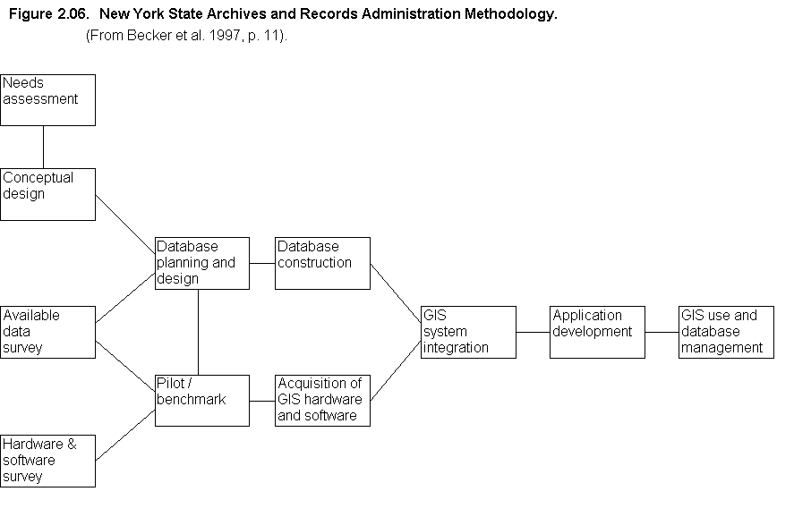
Other GIS design methodologies exist, some of which are geared toward very specific applications. The Local Government GIS Development Guides, produced by the New York State Archives and Records Administration, is one such methodology (Becker et al. 1999). This methodology describes a generalized model with specific procedures and activities describing each step.
Figure 2.06 shows a diagram of the New York State Archives and Records Administration methodology. The methodology has a linear appearance but has a step for the production of a pilot or benchmark system, similar to the Marble and Wilcox methodology. This pilot step is advantageous, although this methodology, like the Marble and Wilcox methodology, does not allow for the reevaluation and change of user requirements.
Although education does not show up as a formal step in the methodology diagram, the procedures of this methodology call for the project participants to attend introductory GIS seminars and workshops and other means of acquiring GIS knowledge (Becker et al. 1999, p. 11). This education step should be explicitly denoted in the design diagram as an indication of its importance. As discussed earlier, education at the start of the process is critical to successful requirements definition.
Another note in the methodology procedure is that the order of the steps in the methodology is not important, but rather that the steps are accomplished, in the authors' words, "one way or another" (Becker et al. 1999, p. 12). The loose structure of the Local Government GIS Development Guides allows the design and implementation process to wander and leads to poor decisions due to a lack of proper preparation. This is particularly likely given the technical and organizational complexity of GIS projects. This is therefore a highly risky means of proceeding. Part of the reason for using a design methodology to guide a GIS project is to avoid an unstructured, wandering project. The structure of a methodology is just as important as its steps to help move projects toward a successful completion.