Lesson 4: Production of Digital Elevation Models
Lesson 4 Introduction
In this lesson, we will also continue the discussion of elevation data in more depth, including many additional forms and formats for the representation of terrain as a base map layer. Photogrammetry was historically the primary approach to elevation data creation; in recent years, technologies such as lidar and IFSAR have surpassed photogrammetric methods for large area collection. We won't have time to discuss the design and operation of those technologies (they are covered in other courses in the remote sensing curriculum); but, we will discuss the elevation products that are generated from all remote sensing technologies.
We will also continue the discussion of specifications and standards; in this case, focusing on those that drive elevation data development at the federal, state, and county level in the United States. This, and the discussion of orthophoto standards, will set the stage for a discussion of data validation, accuracy assessment, and quality assurance/quality control methods which are a critical part of the overall base mapping mission.
Lesson Objectives
At the end of this lesson, you will be able to:
- describe the basic photogrammetric concepts used in creation of digital elevation models;
- explain the characteristics of, and processing methods used to produce, digital elevation models, digital terrain models, digital surface models, and topographic contours;
- discuss the strengths and weaknesses of various types of terrain representation in GIS analysis and applications;
- identify common artifacts and anomalies that occur in elevation data and methods used to correct them;
- identify common elevation data formats and perform conversions from one format to another;
- overlay elevation data with imagery and vector data to prepare for visualization and analysis.
Questions?
If you have any questions now or at any point during this week, please feel free to post them to the Lesson 4 Questions and Comments Discussion Forum in Canvas.
Elevation Data Collection
The geometric conditions of a pair of overlapping photographs, coupled with the evolution of stereo vision in most creatures that inhabit our planet, made photogrammetry the most important method for topographic mapping for over a century. For decades, topographic maps have been irreplaceable planning and design tools for the military, for civil engineers, for scientists, and even for the adventuring public. The depiction and interpretation of terrain data from a 2-dimensional paper product required special skills and considerable practice. While this type of depiction was incredibly useful and enabled many great accomplishments, advances in computer graphics, animation, and 3D rendering in the past few decades are quickly turning the 2D topographic map into a quaint historical relic.
Historically, elevation data was almost always collected as a "bare-earth" model, eliminating above ground features such as buildings, vegetation, and bridges. Today, because many applications make use of the above-ground features, digital surface models which include these features are often specified as additional deliverables.
Stereo aerial photography or satellite imagery is still a very important source of elevation data. Human beings drawing cartographically-pleasing contours by hand is rare in today's mapping industry, but it is still common to manually extract elevation points (mass points) and breaklines along key features of the natural and man-made landscape. Automated image correlation techniques are also useful, although there is almost always a need for manual editing and correction if a clean bare ground surface is desired. Autocorrelation is a fast and effective way of producing digital surface models, particularly for the generation of "true orthophotos." which were discussed in Lesson 3.
Active remote sensing technologies, particularly lidar [1]and IFSAR [2], are quickly gaining acceptance as the most accurate and/or cost-effective ways to collect high-resolution elevation data over large areas. An in-depth discussion of either of these technologies (including sensor design and operation, project planning, data processing, and product generation) is beyond the scope of this course. However, the textbook readings do describe these technologies at an overview level. Most of the information in this lesson, which deals with the elevation data products, rather than the method of acquisition, is applicable regardless of the sensor used for acquisition.
Seamless coverage of the United States with current digital orthophotography has been achieved, and is kept current, by a combination of government and commercial activities. In previous lessons, we discussed federal programs, such as USGS and USDA, and commercial endeavors such as the Microsoft/Bing Global Ortho Project. The USGS has developed and maintained seamless elevation data coverage of the United States through the National Elevation Database, but much of the source information for the NED is very old and of relatively low accuracy and resolution. There is significant interest in upgrading the nationwide elevation coverage with high-resolution, high-accuracy data, but it would require commitment of hundreds of millions of dollars for data acquisition and processing. One of the best cost-benefit arguments for seamless elevation data appears to be in support of FEMAs floodplain mapping program, but the pool of potential users of this data is much larger. Execution of a national elevation mapping program will require a significant number of interagency partnerships and cooperative cost-sharing agreements.
The viability of various remote sensing technologies for creation of a seamless national elevation database was the subject of a National Academies of Science report published in 2007. The study was done for FEMA, and the committee was made up of experts in mapping as well as engineering applications. This report, Elevation Data for Floodplain Mapping [3], can be downloaded for free and provides an in-depth comparison of photogrammetry, lidar, and IFSAR that should more than satisfy the student who would like to read beyond the scope of the assigned reading in this course.
Elevation Data Products
Elevation Data Product Types
A terrain surface can be characterized in many ways depending on the interest and perspective of the end user. This unit provides definitions for the types of terrain models most commonly encountered for mapping and GIS applications.
Digital Elevation Model (DEM)
A digital elevation model (DEM) contains elevations at points arranged in a raster data structure, a regularly spaced x, y grid, where the intervals of Δx and Δy are normally in linear units (feet or meters) or geographic units (degrees or fractions of degrees of latitude or longitude). The z-values in a DEM represent the height of the terrain, relative to a specific vertical datum and void of vegetation or manmade structures such as buildings, bridges, walls, et cetera. The elevation of lakes and rivers in a DEM implies the height of the water surface based on the elevation of the exposed shoreline. The observations, or direct measurements, of elevation that comprise the DEM are almost never actually captured on a regular grid; therefore, the elevation for any given point in the grid is normally interpolated from other forms of source data. Lidar, for example, yields a dense set of irregularly spaced points; interpolation to a grid requires using one of many possible interpolation algorithms, which produce varying results. Linear features, such as streams, drainage ditches, ridges, and roads, are often lost in a DEM if the grid spacing is larger than the dimensions of the feature. Furthermore, in a DEM, it is unlikely that the sharp edge of the feature will be represented correctly in the terrain model. The DEM, because it is a raster data structure similar to a digital image, is an efficient format for storage, analysis, rendering, and visualization.
Digital Terrain Model (DTM)
A digital terrain model (DTM) data structure is also made up of x,y points with z-values representing elevations, but unlike the DEM, these may be irregularly or randomly spaced mass points. Direct observations of elevation at a particular location can be incorporated without interpolation, and the density of points can be adjusted so as best to characterize the actual terrain. Fewer points can describe very flat or evenly sloping ground; more points can be captured to describe very complicated terrain. In addition to mass points, the DTM data structure often incorporates breaklines (further defined below) to retain abrupt linear features in the model. A DTM is often more expensive and time-consuming to collect than a DEM, but is considered technically superior for most engineering analyses because it retains natural features of the terrain.
Digital Surface Model (DSM)
A digital surface model (DSM) includes features above the ground, such as buildings and vegetation, and is used to distinguish a bare-earth elevation model from a non-bare-earth elevation model. The term DSM is generally applied regardless of whether the data are in gridded format (as in the DEM defined above) or mass point format (as in the DTM defined above).
Triangulated Irregular Network (TIN)
A triangulated irregular network (TIN) represents terrain with adjacent, non-overlapping triangular surfaces. A TIN is a vector data structure generated from the mass points and breaklines in a DTM. TINs also preserve abrupt linear features and are excellent for calculations of slope, aspect, and surface area and for automated generation of topographic contours, which are all important functions to the flood study engineering. Storage formats for TINs are more complex than either DEMs or DTMs, because the relationship of elevation points and triangular surfaces must be preserved within the data structure.
Breaklines
Breaklines are linear data structures that represent a distinct or abrupt change in the terrain. They comprise a series of vertices with z-values (elevations) attached. Breaklines contained in a DTM will be forced as edges in a TIN model. Breaklines are usually stored in separate files, as lines with 3-dimensional vertices, in a variety of common CAD or GIS file formats.
Contours
Contours are isolines of elevation; they are the traditional method for representing a three-dimensional surface on a two-dimensional map. They are excellent for human interpretation, but inferior to DEMs, DTMs, and TINs for computer display and analysis. Historically, contours were drawn by hand and smoothed to produce a cartographically pleasing product. Now, automated methods for producing contours from TINs or DEMs are available, but the final product contains no new information and adds little value to an engineering analysis. Contours are usually stored as two-dimensional lines, with an attribute or label containing the appropriate elevation value.
Elevation Data Product Specifications
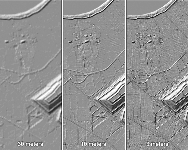
Data product specifications for terrain models normally include a vertical accuracy requirement and some indication of the desired density of x, y, z points used to create the terrain models. For a DEM, the post-spacing is defined by the distance between points on the elevation grid. As with imagery, it makes little sense to define a DEM post spacing that is denser than the nominal point spacing of the source data. Based on the end user application, the data acquisition specification should ensure that the nominal point spacing, or ground sample distance, exceeds the post spacing required for the final deliverable product.
Specifications for breaklines usually adhere to the same vertical accuracy requirement defined for the mass points, and, in addition, stipulate which linear features are to be collected (i.e., road centerlines and/or edges, water body centerlines and/or edges, berms, levees, retaining walls, etc.).
Contour data products are specified by the desired contour interval; for example, a 5-foot contour dataset would contain a set of isolines at elevations of 0 feet, 5 feet, 10 feet, 15 feet, etc. The contour interval is usually chosen to represent as much terrain detail as possible without making the map or visual display overly crowded or cluttered; flatter areas will usually have smaller contour intervals, and hilly areas will usually be represented with larger contour intervals. If the terrain over the study area varies greatly, it may be difficult to arrive at one optimal contour interval for the entire project.
Elevation Data Formats
As you have seen, there are a number of inherently different ways of representing elevation data: grids, points, TINS, contours, etc. For each one of these data types, there are multiple file formats that can be used to save and exchange them.
Point Cloud
Elevation data can be a simple collection of XYZ points, often called a point cloud when the points are numerous and very densely spaced, as with lidar data. Point data is conceptually simple; however, it is often advantageous to attach a large number of attributes to each point, in which case, the file structure can become very cumbersome very quickly. ASCII and SHP work for small datasets, but are very inefficient for large numbers of attributed points.
- ASCII
- Esri SHP
- LAS - a binary point-based data format, maintained by ASPRS, designed specifically for lidar datasets contains millions of points with numerous attributes.
Digital Elevation Model (DEM)
A DEM is a raster, just like an optical image, so it can be stored in many of the common image formats described in Lesson 4. The important difference is that each cell in an image raster usually contains a discrete integer value (for example, in an 8-bit image, each cell contains an integer value from 0 - 255), whereas elevation values are continuous and can be expressed with decimal places appropriate for the accuracy of the data. Elevation rasters, therefore, are defined to store floating point [5] values rather than integers.
Commonly encountered raster elevation formats, previously described as image formats, are:
- TIF and GeoTIF
- IMG
- Esri GRID
- SID - While it is possible to store elevation data in the compressed SID format, I have honestly never been given one or seen SID format specified as a deliverable in a civilian or commercial project. One would want to be careful about using compression on a DEM, because any alteration to the original pixel value (in lossy compression) would affect the spatial accuracy of the dataset and could potentially change the results of spatial analysis.
Common raster formats specifically designed for elevation data only are:
Both of these formats are used for specific data products that meet USGS or NGA product standards; post-spacing, accuracy, and collection methods are prescribed in addition to the format of the file itself. These formats are only used for these USGS and NGA products; they are not generally used for more generic elevation datasets.
Digital Terrain Model (DTM)
A digital terrain model consists of 3D points and 3D breaklines. There are a number of CAD data formats, such as AutoCAD DXF and Microstation DGN, which hold both point and line data in a single file. This is less common in GIS, where files are normally restricted to one type: either point, line, or polygon. Geodatabases can contain multiple feature classes to accommodate these multiple topologies.
Digital Surface Model (DSM)
A DSM is a special case of either a point cloud, a DEM, or a DTM; the difference is whether the elevation surface represented is bare ground or if it contains above ground features. Data formats used for DSMs are the same as for point clouds, DEMs, and DTMs described above.
Triangulated Irregular Network (TIN)
TINs are an efficient representation of terrain for visualization and analysis, but they are most efficiently used when generated on-the-fly and stored in random access memory (RAM). Points, DEMs, and DTMs can all be used to generate TINs, and there are many different TIN generating algorithms and data formats; some are open source but many are proprietary. It is quite uncommon to see a TIN specified as a deliverable product; therefore no specific TIN formats are presented here.
Breaklines
Breaklines are 3D lines, and they can be represented in any number of common 3D polyline formats, such as:
- DXF
- DGN
- SHP
Contours
Contours are isolines of elevation; a single contour line has the same elevation value everywhere. Historically, contours were often stored as 2D lines, with the elevation added as an attribute or label. That approach makes it very difficult to do any kind of 3D analysis on a contour layer; therefore, it is most common today to find contours in the same 3D polyline formats described above for breaklines.