Lesson 3: GIS and Geospatial Analytical Modeling
3.0 Introduction to Lesson 3
Market Research provides relevant data to address the challenges that organizations face today and tomorrow. It is nearly impossible to segment a market or differentiate a product/service without market research. As such, it involves gathering, organizing, verifying, analyzing, and interpreting information that relates to the creation, delivery, and maintenance of products/services that meet or exceed customer expectations as they are positioned in the marketplace with respect to competitors.
For our purposes to develop location intelligence to solve business problems, brainstorm various sources of geospatial data which are relevant to the business question. Geospatial intelligence (GEOINT) analysts examine imagery and imagery products, imagery intelligence, and geospatial information for patterns, observations, changes, and to develop assessments. Similarly, geospatial analysts in the business, humanitarian, healthcare, or municipal sectors examine maps, geospatial data, GIS records, census data, imagery when applicable, geographic studies, and volumes of disparate data to develop location intelligence. Consider both geospatial concepts and business principles through the course to address each problem or assignment.
In this lesson, we will examine a geographic area within which an organization operates and draws most of its business. Site selection for a business doesn’t always refer to determining the most profitable real estate for a new store, coffee shop, or distribution center. It may also reflect:
- growing or shrinking a business chain in the right places & right ways (optimal for that business);
- identifying geospatial or human geography factors that influence Latin American customers to prefer certain product lines over South Asian customers;
- proximity isn’t always a least distance in a global eCommerce market.
A key feature is the advantage that location provides to the business: proximity to customers, markets, competitors, services, opportunities. Location intelligence is applying geospatial analysis to location-based business topics. To successfully accomplish this, you must have a thorough understanding of business strategies, geospatial science, and the analytical process involved. The purpose of a location intelligence study for business is not just marketing. The rationale may be using principles of location intelligence to discover customer behaviors and trends to predict future opportunities.
- Business expansion
- Planning and evaluating marketing campaigns
- Sales prediction and forecasting
- Store planning
- Product mix for customers, markets, or retail stores
- Supply chain networks
- Risk assessment
- Product inventory and asset management
As previously stated, begin each project or location intelligence project with the end in mind. How will the geospatial analyst present the results of their business problem modeling and location intelligence analysis to the project team, a decision maker, or requesting client? Geographic information systems (GIS) are often used to manage, analyze, visualize, and gain an understanding of geospatial data. Other courses in your graduate studies present far greater depth in the design of GIS, integrating GIS platforms into business operations, and managing data for an organization.
Learning Objectives
At the successful completion of Lesson 3, you should be able to:
- identify a trade area based upon demographic profile;
- identify a trade area based upon psychographic profile;
- identify physical and man-made features in a region (e.g. transportation networks) and discuss how these features can create a barrier to trade;
- describe how geocoding, thematic mapping, and buffer zones apply to market research;
- identify a Term Project topic relating to location intelligence.
- summarize ethics standards for data management
What is due for Lesson 3?
Lesson 3 will take us one week to complete. There are a number of required activities in this lesson, listed below. For assignment details, refer to the lesson page noted.
Note: Please refer to the Calendar in Canvas for specific time frames and due dates.
| 3.1 GIS & Geospatial Analysis | ||
|---|---|---|
| Requirements | Details | Access / Directions |
| Read | Read the course content. | Use the Lessons menu or the links below to continue moving through the lesson material. |
| Murray, Peter, 4 Ways Data Enrichment Can Improve Your Raw Business Data [1]. CARTO Blog: Location Intelligence. | Registered students can access the reading in Canvas on the Lesson 3 Readings page. | |
| GIS & Geospatial Analytic Modeling, Ch 1 | Registered students can access the reading in Canvas on the Lesson 3 Readings page. | |
| Links to other examples of Geospatial Analytical Modeling | Registered students can access the reading in Canvas on the Lesson 3 Readings page. | |
| Deliverable | No Deliverable | N/A |
| 3.2 Orientation to ESRI Business Analyst Online | ||
|---|---|---|
| Requirements | Details | Access / Directions |
| Read | Read the course content. | Use the Lessons menu or the links below to continue moving through the lesson material. |
| Miller, Case study and instructions, Getting to Know Business Analyst, Chapter 1 | Registered students can access the reading in Canvas on the Lesson 3 Readings page. | |
| Church, Business Site Selection, Location Analysis, and GIS, Chapter 1 (pp. 1-16) | Registered students can access the reading in Canvas on the Lesson 3 Readings page. | |
| Buckner, Site Selection, Chapter 6 "Prioritizing Markets" (pp. 74-84) | Registered students can access the reading in Canvas on the Lesson 3 Readings page. | |
| Murphy, Geography: Why It Matters, Chapter 3 "Places" excerpt (pp. 75-86) | The Geography: Why it Matters reading is from the required textbook. | |
| Optional Reading | Esri, Tapestry Life Mode Reference Tables. Tapestry Segmentation | Registered students can access the reading in Canvas on the Lesson 3 Readings page. |
| Spaeder, “How to Find the Best Location” | Registered students can access the reading in Canvas on the Lesson 3 Readings page. | |
| Deliverable | No Deliverable—post questions or comments if you wish. | Optional: post comment in Canvas on the Lesson 3.2 Open Discussion (Ungraded). |
| 3.3 Exploring Your Own Market, Part 1 | ||
|---|---|---|
| Requirements | Details | Access / Directions |
| Read | Read the course content. | Use the Lessons menu or the links below to continue moving through the lesson material. |
| Do | Exploring Your Own Market, Part 1 | Course text and in Canvas on the Lesson 3 Readings page. |
| Deliverable | Part I—Exploring Your Own Market, due Tuesday. | Submit in Canvas to the Lesson 3.3 Activity: Exploring Your market drop box. |
| 3.4 Ethics of Data Management | ||
|---|---|---|
| Requirements | Details | Access / Directions |
| Read | Read the course content. | Use the Lessons menu or the links below to continue moving through the lesson material. |
| Links to Ethical Decision Making references | Registered students can access the reading in Canvas on the Lesson 3 Readings page. | |
| Deliverable | No Deliverable | N/A |
| 3.5 Term Project Identifying Topic and Providing Peer Feedback | ||
|---|---|---|
| Requirements | Details | Access / Directions |
| Read | Read the course content. | Use the Lessons menu or the links below to continue moving through the lesson material. |
| Deliverable | Term Project – post your Project Topic and provide feedback to peers, due Tuesday. | Submit in Canvas to the Lesson 3.5 Term Project: Topic Idea drop box. |
3.1 GIS & Geospatial Analysis
One of the main objectives in this course is to enable you to:
- Design, develop, and critique geospatial analysis workflows to perform tasks, answer questions, and solve location-based business problems.
- To successfully accomplish this, you must be grounded in geospatial data science, be comfortable working with new geospatial software packages, use critical and analytical thinking.
- Evaluate and manage location data; enriching, analyzing, storing, and visualizing.
Segmenting Markets and Customers for business objectives causes a corresponding reorganization of geospatial data. Recognizing this connection expands one's ability to identify key factors, perform geospatial analysis, and design models of the business problem. Often the goal is to discover customer behaviors and trends to predict future opportunities and identify how location impacts the business strategies. Current analysis techniques include digital transformation of the organization's data, connected sensors, and the Internet of Things (IoT).
In Geography: why it matters, Murphy repeatedly emphasizes how people develop attachments to places and regions. Consider the human factor in geography and geospatial studies to understand why people live there or how a town formed at the confluence of a major river, convenient rail and road transportation routes, with arable land and space for large manufacturing operations. The base or foundation of a successful geospatial analysis examining a business problem begins with understanding the context of the market, demographics, consumer needs, history of that business and a connection to its location, and possibly unique factors that impede or support the organization's success.
People do not simply occupy or visit places; they develop attachments to them that influence what they do, how they think about the world, and even how they construct their own identities.
It follows that grasping the nature of places requires consideration not just of their overt characteristics, but also of the way people think about and experience them. In an influential 1976 study entitled Place and Placelessness, University of Toronto geographer Edward Relph looked at the proliferation of look-alike commercial strips in and around North American cities. Terming these "placeless landscapes" (because they are ubiquitous and ignore the individual characteristics of the places where they sprang up), Relph invited us to think about what happens when landscapes reflecting people's geographical and historical sensibilities are replaced with cookie-cutter urban developments that can be found anywhere. (Murphy, 2018, pp.75-76)
Geospatial Data Sourcing
A business directly and indirectly collects significant volumes of data on its market, customers, products, operations, and operating environment. Analysts are apt to find the data is both structured and semi-structured, requiring capabilities to store, process, and analyze non-conforming and dissimilar data formats. In order to perform a valid analyis of the data and form hypotheses or models of the business problem, additional information is typically required to connect location-based relationships, relate context to differences in quarterly sales reports, and discern anomalies from random observations. The additional information might include geospatial reference data, imagery, consumer marketing, social media, demographics, and typological physical and human geography features.
Advanced data sourcing provide opportunities to improve location intelligence and leverage the volume and velocity of geospatial data collected by IoT sensors, enterprise computer networks, and data mining techniques.
-
Human geography and social networking - studying human behavior with operational technologies to recognize, categorize, and interpret relationships of individuals, groups, and organizations.
-
Forecasting - process from operations research to anticipate events, trends or trendlines, or expected future results.
-
Crowdsourcing - operationalized process where individuals gather, share, and analyze geospatial information in a connected or online network. Access is provided for others to view or use the raw information and results of developed assessments.
Budgets often impact a department's access to business and geospatial data. Some businesses have large cash reserves or cash flow to purchase the volume and detailed data they require to effectively and profitably make decisions. Others must decide between purchasing data or operating the business. The timing of reports and subsequent analysis can provide an advantage to an organization that invests in current and well-organized third-party data. Savvy analysts seek alternative sources of geospatial data to return value to the organization, e.g. Cloud-based data services included in software licenses, crowdsourced information, and trade organization data.
Geospatial Analysis
Geospatial analysis is evolving with technological advances in:
-
Data Collection: prolific remote sensing, IoT smart communities, business data;
-
Data Management: cloud computing, AI, coding, and computing speed (SSD, 5G, storage);
-
Data Enrichment: access to open source imagery, news, and geospatial information;
-
Geospatial analysis;
-
Crowdsourcing, volunteered geographic information (VGI), alternatives to major or expensive location intelligence sources.
Collecting relevant and accurate data starts the geospatial analysis process. What is related to the business question, is data available, and who determines access? What data formats meet your analysis department’s IT system and schema? Typically, a business does not have all the georeferenced information available to fully develop location intelligence. What information is required to develop the next fiscal year's retail distribution strategy, to array an optimal bank branch distribution to reach consumers, or site planning for the healthcare industry?
Data enrichment adds geospatial, imagery, consumer marketing, social media, demographics, physical and human geography information to examine factors of the business problem. The geospatial professional designs, stores, and accesses a GIS that meets the needs of the business and geospatial analysis.
Data enrichment process that enhances, refines, or otherwise augments existing data, typically with imported datasets. Geospatial analysts geocode inconsistent data, augment routing information, enrich point data with Areas of Influence Analysis (isolines of relative information), and often incorporate demographic measures to get a better picture of the customer or target audience. (Murray, 2017)
O’Sullivan and Unwin describe geographic information analysis as investigating patterns found in spatial processes that may be operating in the space of points, lines, and fields. (O’Sullivan & Unwin, 2003:3) There are many methods of geospatial analysis; it's important to understand the functions of each analysis and match your choice to the factors of the business problem. What questions must be answered to reach a solution for that problem? Recognize how important the concepts of space and time have in analysis. Spatial analytics merge GIS with other types of data and analysis; at times requiring specialized geospatial software to dependably preserve network relationships. Spatial-temporal patterns indicate physical activiites and social behavior which relate to the business problem or modeling.
Geospatial analysis for location intelligence can be:
-
Descriptive: what happened?
-
Diagnostic: what’s happening now?
-
Predictive: what could happen?
-
Prescriptive: what should happen?
-
Optimized: what’s best to fit certain quantifiable business criteria?
Geo-Awareness
In your research, seek the most relevant, useful geospatial data sources or collections. Determine how the geospatial data meet your needs for metadata, scale, currency or timeliness. Location intelligence structured and unstructured data sources may be found in business systems, social media, embedded sensors (e.g., vehicle telematics), company portals, mobile apps, open source, third-party geospatial information, and complimentary information (e.g., insurance FIC scores, building repair costs, business formation data).
Today there is more geo-awareness - and those who are both aware of and using geospatial technologies enjoy a significant advantage - the geo-advantage. Geo-advantage comes from not only being aware of the technologies, but also of the data or information available, having access to that information, and knowing how the information can be used to provide a competitive advantage in the GeoEconomy. Together these can collectively be referred to as the geospatial infrastructure. (Ryerson, 2010, p.39-40)
Read
- Murray, Peter, 4 Ways Data Enrichment Can Improve Your Raw Business Data [1]. CARTO Blog: Location Intelligence.
Optional Readings
- David O’Sullivan and David J. Unwin. 2003. Geographic Information Analysis. Hoboken, NJ: John Wiley & Sons.
- Nathan Heazlewood. GIS GIGO (Garbage In Garbage Out): 30 checks for data error [2].
3.2 Orientation to Esri Business Analyst Online (BAO)
Read:
Miller, Getting to Know Esri Business Analyst, "Part I: Trade area analysis and site reporting with Esri Business Analyst Online" (pp. 2-6)
Registered students can access the reading in Canvas on the Lesson 3 Readings page.
The above reading is the introduction to a scenario from Miller's text which you can use to orient yourself to Esri's Business Analyst Online.
In this lesson, we provide a brief overview of Esri's Business Analyst Online (BAO). BAO includes Esri's most current business, demographic, and lifestyle data:
- Business Data: Refreshed data for the United States and Canada from Dun and Bradstreet.
- Esri's 2020/2025 US Updated Demographics: Accurate, current-year estimates and five-year projections capture changes to the US population such as growth and decline; increased diversity; aging; and changes to household types, home values, employment, and income.
- 2019/2024 US American Community Survey (ACS): Updated survey data from the Census Bureau. Variables include households with/without a disabled person and households using food stamps.
- Esri's 2020 Tapestry Segmentation: Tapestry reflects changes in the US population such as increased diversity, changing households, aging, and nontraditional families.
You will be receiving an email from the instructor with directions to access the Penn State licensed Esri Business Analyst Online, using your PSU username and password. The email provides access to the BAO system and class group work, so please be sure to check your Penn State email. Once logged into the site, you will notice that additional help documentation is available as well as instructional videos on the website.
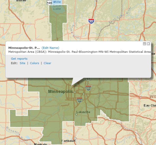
- Log into Esri's BAO.
- Select the "Maps" tab.
- Choose "Define Areas for Reports."
- Select "Geography," search for your geography, enter ("Minneapolis, MN"), Go.
- Select the radio button for "Metropolitan Areas (CBSAs)," check Minneapolis-St. Paul, Click "Next."
- You should now have a polygon on the map around Minneapolis MN (see Figure 3.1).
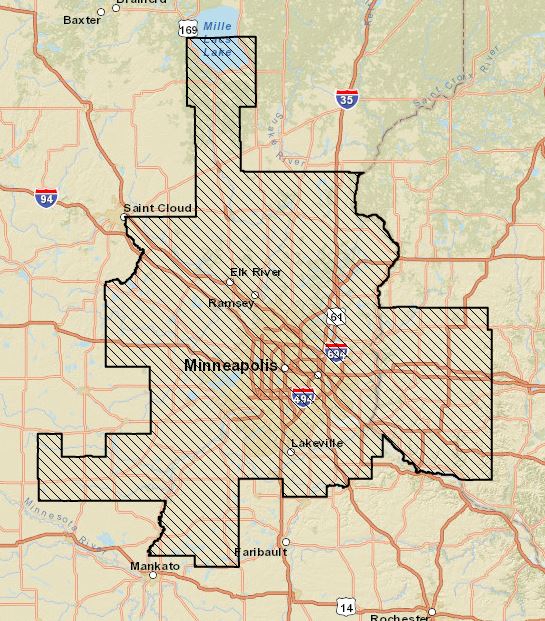
You can practice and improve your business analysis of a geographical area using Esri's BAO.
Upcoming assignments will involve creating choropleth maps and using Esri's Tapestry data on BAO. Familiarize yourself with those two topics by utilizing Esri's documentation and instructional videos to help you better understand how to display the information.
There are many techniques for statistically segmenting populations and geographies, each based on the collected or calculated data, scientific methodology, standards, and purpose of the segmentation. Esri builds their Tapestry market segmentation system from demographic and socioeconomic variables; identifying and labeling unique consumer markets throughout the U.S. (Esri Demographics, 2022). The Tapestry includes 67 market segments which are then summarized in 14 LifeMode and 6 Urbanization groups. Esri describes these where "LifeMode groups share similar demographic characteristics and consumer behavior patterns while Urbanization groups are based on the segment's geographic and physical features".
Tapestry Segmentation from the Esri website, Esri Demographics [3]:
LifeMode Groups
LifeMode groups represent markets that share a common experience-born in the same generation or immigration from another country, for example—or a significant demographic trait, such as affluence. Tapestry segments are classified into 14 LifeMode groups:
- LifeMode 1 Affluennt Estates
- LifeMode 2 Upscale Avenues
- LifeMode 3 Uptown Individuals
- LifeMode 4 Family Landscapes
- LifeMode 5 GenXurban
- LifeMode 6 Cozy Country Living
- LifeMode 7 Sprouting Explorers
- LifeMode 8 Middle Ground
- LifeMode 9 Senior Styles
- LifeMode 10 Rustic Outposts
- LifeMode 11 Midtown Singles
- LifeMode 12 Hometown
- LifeMode 13 Next Wave
- LifeMode 14 Scholars and Patriots
Urbanization Groups
Tapestry groups are also available as Urbanization summary groups, in which markets share similar locales, from the urban canyons of the largest cities to the rural lanes of villages or farms. Tapestry segments are classified into six JUIrbanization groups:
- Principal Urban Centers
- Urban Periphery
- Metro Cities
- Suburban Periphery
- Semirural
- Rural
There are open resources for learning Esri's Business Analyst Online:
- Be sure to visit the Esri site which offers a tutorial on the basics of creating a color-coded map that reviews all segments of the search without the specific search criteria [4].
- This one page will direct you to just about every feature in BAO. [5]
- See a demonstration of a few of the capabilities of BAO software as a service for small business for site-based location analysis. [6]
- A great video for GIS-trained people interested in how Business Analyst Online can integrate with ArcGIS Desktop. [7]
Note:
We will only complete the first part of this activity this week (Exploring Your Own Market, Part 1), continuing on with site selection next week.
Read
- Murphy, Geography: Why It Matters, Chapter 3 "Places" excerpt (pp. 75-86)
- Church/Murray, Business Site Selection, Location Analysis, and GIS, Chapter 1 (pp. 1-16)
- Buckner, Site Selection, Chapter 6 "Prioritizing Markets" (pp. 74-84)
- Esri. 2019. Tapestry Life Mode Reference Tables [8]. Tapestry Segmentation. Esri.
The Geography: Why it Matters reading is from the required textbook for this course.
Registered students can access the other readings in Canvas on the Lesson 3 Readings page.
Optional Readings
- Spaeder, Karen. E. 2019. How to Find the Best Location: A guide to scouting out a location for your food or retail business, sizing up demographics and getting the help you need [9]. Entrepreneur.
- Kerski, Joseph & Clark, Jill. 2019. GIS Guide to Public Domain Data. Esri Press.
- ArcGIS Hub open data portal. Esri. www.arcgisonline.com [10]
Registered students can access the reading in Canvas on the Lesson 3 Readings page.
Deliverable:
There are no deliverables for 3.2.
3.3 Exploring Your Own Market, Part 1
Activity - Exploring Your Own Market with Esri's Business Analyst Online (BAO), Part 1
Now is your chance to explore your own market!
Returning to some of the questions which came up as we worked through the material on segmentation, now turn to your own area of interest and investigate further. In this activity, you are free (and encouraged) to explore different data variables, levels of geography, data classification, and map design to illustrate your own market.
Spaeder (2019) reiterates that at startup, location may be the most important thing in preparing to open a food or retail business with a storefront. This activity reinforces four points the author highlights:
- Start with questions to develop criteria.
- Examine demographic data.
- Identify competitors.
- Seek professional help.
Your goal is to examine the demography of your area of interest with what you uncovered about your ZIP code in the previous activity. Though you do have the option to look at other levels of geography as well.
This activity will take place in two parts. In Part 1 (this week in Lesson 3), we will look primarily at demography and in Part 2 (next week in Lesson 4), we will continue with a deeper look at Esri's Tapestry segmentation.
Suggestions
- Do investigate your market in BAO first at the ZIP code level. Following the ZIP code, you will add to your investigation with other levels of geography.
- Do include an analysis of demographic attributes as you "ground truth" your market. You'll want to look at some of the key demographic variables (population, marital status, income, home tenure, children, etc) we discussed last week. However, small level Census geography results for the 2020 Census may not be available. It's fine to choose to use the Esri "20XX/20XX Demographics" modeled data OR the "ACS 20XX-20XX" averages (where "XX" represents the most current data years available), as the 2010 Census data may not be current enough for our purposes, and the 2020 data may not be fully available yet for smaller geographies.
- You may wish to spend a moment reviewing Esri's Tapestry Segmentation [11]. You'll find both a handy poster overview and a reference guide. In addition, you may wish to try to "match up" your PRIZM segment (much the way you did with Mosaic) to a corresponding segment in Tapestry BEFORE you start making maps. However, your goal this week is to consider demographic variables in Esri's software service. (You'll look at Tapestry segments for your area next week in more depth.)
- Feel free to have a discussion about the datasets you draw from, share tips, and pose questions in the discussion forum.
- DON'T wait until the last minute—DO start early, sharing findings and tips with each other, and asking questions if you get stuck.
Deliverable Lesson 3.3 Activity:
A Word .doc/.docx submitted to the Lesson 3.3 Drop Box - Exploring Your Own Market, Part 1 in Canvas. Your submission should include the following:
- A write-up describing what you found using your Esri BAO demographic research. Your write-up should be about 3-5 concise paragraphs and should include:
- The ZIP code or any other identification information you used in your search (choices of geographies by county, tract, block group, etc.)
- Highlight any key demographic variables that were included in the segment description.
- After introducing your observations at the ZIP code level, please choose one other geographic level that does an even better job of characterizing what you think of as your segment, and elaborate as you did with the ZIP code information.
- Characterization of your "place" (this may be your metropolitan area, city, town, etc.). Please consider if it is a CBSA and how it relates to the larger area (is your area core/central city, suburb, commuter town, etc?)
- Your BAO generated maps—at least 2 but no more than 4 images please—submitted as .jpg/.pdf.
- While your maps needn't be publication quality, please do make conscious choices about map extent, data classification and design (including a legend).
- Please include at least one map at the ZIP code level (showing your ZIP code, of course).
- Please include at least one map at the tract or block group level (justifying your rationale).
- Make sure your maps support your case!
Due Tuesday night 11:59 pm (Eastern Time).
3.4 Ethics of Data Management
As geospatial professionals, we have a duty to act responsibly, meet ethical standards in our work, and to respect the privacy of others. Simply because one can access data in a search does not automatically authorize an organization to use that data. An integrity challenge exists when researching open source, third-party, and proprietary data for analysis and writing.
An analyst must recognize the ethical considerations to understand whose information they found, how their actions may adversely impact the organization, and what is allowed. These ethics standards of business data apply to the collection, storage, and use of data for business decisions. Ensure that you understand the licensing rules of openly sourced data for proper citation, individual use, or dissemination.
When performing searches for geospatial or business information, one must ask questions to reflect on the ethics of storing, managing, and sharing the data:
- What information is allowed to be collected for this project or by my organization?
- What is the objective, what will be achieved using the data?
- Who's data did the search uncover?
- Will disclosure of the data harm any person or entity?
- Should I proceed? Do we have the right to include this?
- How can I achieve the project objective without creating an adverse event?
When designing a GIS, collectively planning business strategies, or creating a geospatial database for a specific project, one must consider the ethics of data:
- collection - citation, credit, attribution
- storage - permission for use, scope of access to one user or all in an organization
- use of data - copyright, trademark, secrets, ownership
The Geospatial Data Act of 2018 created a unifying policy covering the use and open sharing of geospatial data. The U.S. National Spatial Data Infrastructure (NSDI) establishes:
- National infrastructure for geospatial applications and services;
- Source of current and accurate geospatial data for open use from local to global access;
- Foundation of geospatial data to improve decision making in public and private sector;
- Resource for people and organizations working towards common goals.
While there are many stories and movies created to glamorize corporate spying, it is illegal under the Economic Espionage Act of 1996 to steal, misappropriate, sell, or pass along trade secrets that have a monetary value to a business.
Professional research conducted legally is appropriate, assists companies to optimize their operations and budgets, and potentially benefits consumers with access to products that meet their needs.
Read:
- Penn State University. Ethics Education for Geospatial Professionals Products [12]. GISProfessionals.org.
- University Consortium for Geographic Information Science (UCGIS). 2019 Professional and Practical Ethics of GIS&T [13].
- Tewelow, William. 2018. Geospatial Data Act will bring huge changes to America, and the world [14]. Geospatial Solutions. 14 Nov 2018.
- U.S. Department of Commerce. 2004. Business Ethics: A Manual for Managing a Responsible Business Enterprise in Emerging Market Economies [15]. Washington, D.C.: International Trade Administration.
Registered students can access the readings in the Lesson 3 Readings page in Canvas.
3.5 Term Project - Identifying a Topic and Providing Peer Feedback
Deliverable:
You will post your topic for the term project in Canvas to the Term Project: Topic Idea forum.
- Only a minimal description of the project is required at this stage, identifying a topic and its geographical scope. When I say minimal, I mean one or two paragraphs.
- Timely submission of your preliminary project topic and scope is worth up to 20 points of the total 300 points available for the term-long final project.
- You may find Esri BAO useful in your project, the economic and demographic data is available as a Penn State graduate student.
Then, comment on 2 other students' topic ideas. The more feedback given at this early stage the better your final project will be.
Due Tuesday 11:59 pm (Eastern Time)
Additional Term Project Notes:
Peer Review and finalizing your project proposal. Over the next few weeks, you will be refining your term project and receiving feedback from me and your peers.