Lesson 5: Risk Assessment Factors
5.0 Introduction to Lesson 5
An organization’s ability to acquire, integrate, disseminate, and apply geospatial information is key to assessing risks and managing crises today. The need is apparent in industry sectors involving emergency services, protection, telecommunications, information services, energy, transportation, banking, financial services, water supply, and healthcare. Businesses that understand their physical and social surroundings can better assess the risks in the communities where they operate as well as the extent of their exposure. By doing so, organizations can create a safer and healthier workplace. At the same time, a business needs to identify, avoid, and plan to overcome a crisis so that it can restore some form of normalcy to its people and holdings that serve its customers.
This lesson is intended to support other Certificates, MGIS courses, and Risk Assessment activities. The study of risk assessment coincides with the instruction of ethics in decision making, sustainability, and project management. Risk analysis and risk assessment is integral to businesses for physical security of property, lives, and products; cybersecurity; business opportunities or the denial of intrusion; planning and operations.
For the financial sector, the course specifically includes an application of GIS and geospatial analysis to Anti-Money Laundering and Counter Threat Finance.
Effective anticipation of risks and planning to mitigate threats reduces potential losses of life, property, productivity, and a business' financial value. With a geographic perspective, risk assessments include GIS management, georeferenced information, maps, and scenario-based projections of where people may be located in potential hazardous situations.
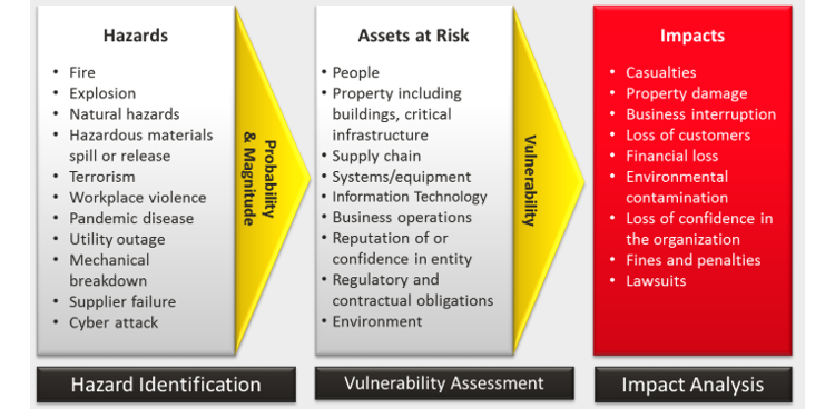
Risk management fully includes risk identification, analysis, response planning, monitoring and finally, risk response and control. For this lesson, we review potential risks to a business, crisis response, and work on an anti-money laundering case study. Consider what regulations, rules, laws, and international norms guide the conduct of employees. What higher authorities - local to global - impact a business? Using every applicable resource, plan how to mitigate threats.
Risks and Threats.
The risk of a situation involving exposure or danger is a function of threats, vulnerabilities, and potential consequences to the entity. While open to subjectivity, risk may be roughly approximated as:
Risk = f (T x V x C),
Risk is a function of the product of Threat times Vulnerability times Consequence, where
T, Threat is the possiblity of trouble, danger, hazard, or ruin.
V, Vulnerability is the exposure of an organziation or measure of the possibility to be harmed.
C, Consequence is the effect or result of an action against the organization.
Teamwork for this 2-Week Lesson Block.
During Lessons 5 & 6, you will work as a team to analyze an AML/CTF Case Study. I will assign teams depending on the number of students enrolled this semester and if groupings by time zones assists in your availability to collaborate.
Learning Objectives
At the successful completion of Lesson 5, you should be able to:
- compare and contrast risk assessment and crisis management;
- identify the geospatial data and methodologies employed in risk assessment and crisis management;
- outline the three steps of money laundering;
- structure the workflow of a geospatial analysis to support anti-money laundering or counter threat finance investigations;
- determine the placement actions of money laundering from a financial transaction data sample;
- present findings of exploratory data analysis of a geospatial data set;
- propose suggestions to peers to improve their Term Projects
What is due for Lesson 5?
Lesson 5 will take us one week to complete. There are a number of required activities in this lesson listed below. For assignment details, refer to the lesson page noted.
Note: Please refer to the Calendar in Canvas for specific time frames and due dates.
| 5.1 Risk Assessment, Sustainability, and Crisis Management | ||
|---|---|---|
| Requirements | Details | Access / Directions |
| Read | Read the course content | Use the Lessons menu or the links below to continue moving through the lesson material. |
| Donovan, Disaster Risk and Site Selection | Registered students can access the reading in Canvas on the Lesson 5 Readings page. | |
| Murphy, Geography, Why It Matters, Ch.4 Nature and Society (pp.87-109) | The Geography: Why it Matters reading is from the required textbook for this course. | |
| Ryerson, Why Where Matters, Section 3.2.4 | Registered students can access the reading in Canvas on the Lesson 5 Readings page. | |
| Do | Business Risk Management activity | Directions are provided in the course text. |
| Deliverable | Discussion on Business Risk Management, due Tuesday | Post comment in Canvas to the Lesson 5.1 - Risk Assessment forum |
| 5.2 Anti-Money Laundering / Counter Threat Finance Investigations | ||
|---|---|---|
| Requirements | Details | Access / Directions |
| Read | Read the course content | Use the Lessons menu or the links below to continue moving through the lesson material. |
| Fruth, “Anti-money laundering controls failing to detect terrorists, cartels, and sanctioned states” | Registered students can access the reading in Canvas on the Lesson 5 Readings page. | |
| U.S. Treasury, National Money Laundering Risk Assessment. | Registered students can access the reading in Canvas on the Lesson 5 Readings page. | |
| U.S. Treasury. National Terrorist Financing Risk Assessment. | Registered students can access the reading in Canvas on the Lesson 5 Readings page. | |
| Deliverable | No Deliverable | N/A |
| 5.3 Location Intelligence to Support AML/CTF Investigations | ||
|---|---|---|
| Requirements | Details | Access / Directions |
| Read | Read the course content | Use the Lessons menu or the links below to continue moving through the lesson material. |
| Exploring Potential Uses of GIS and Predictive Analysis in AML/CTF Investigations | Registered students can access the reading in Canvas on the Lesson 5 Readings page. | |
| Deliverable | No Deliverable | N/A |
| 5.4 Case Study: Location Intelligence to Support AML/CTF Investigations | ||
|---|---|---|
| Requirements | Details | Access / Directions |
| Read | Read the course content | Use the Lessons menu or the links below to continue moving through the lesson material. |
| Do | Case Study, Part 1 | Directions are provided in the course text. |
| Deliverable | Part 1 - Placement & Layering, Case Study: Location Intelligence to Support AML/CTF Investigations, Part 1 due Tuesday | Submit your deliverable in Canvas to the Lesson 5.4 Activity: Case Study - Part1 drop box |
| 5.5 Term Project Providing Peer Feedback and Continue Working | ||
|---|---|---|
| Requirements | Details | Access / Directions |
| Read | Read the course content | Use the Lessons menu or the links below to continue moving through the lesson material. |
| Do | Continue Working on Your Term Project | Manage your time wisely |
| Deliverable | No deliverable required this week. | |
| Optional | Additional Readings, Penn State's GeoVista Center and others | Registered students can access the reading in Canvas on the Lesson 5 Readings page. |
5.1 Risk Assessment, Sustainability, and Crisis Management
Risk Assessment
Risk Assessment involves weighing the impact of threats, positive or negative, on objectives and finding the best ways to control the risk by accepting, avoiding, transferring, or mitigating the effects of those threats and communicating it in a succinct and quality manner.
Risk is typically assessed across the following geospatial parameters:
- Probability of something going wrong, e.g. hazard due to physical changes, environmental, man-made, man-induced, collateral or incidental events
- Exposure of people, assets, civil and business entities
- The negative consequnces; vulnerability of personal, societal, and economic conditions
The goal is to consider the potential damages, losses, and/or mitigation of risk. For example, the risk posed by severe storms can be analyzed by looking at weather hotspots (cyclone, tornado, hurricane, lightening, etc., frequency) and calculating the exposure through population density. High-resolution satellite data can be used to derive physical risk and exposure data in combination with GPS data collection.
Risk is inherent to business and needs to be analyzed in terms of potential threats from within the organization (employees, production, administration, etc.), potential threats from outside the organization (customers, vendors, partners, products, services, etc.) and from the supply chain(s) in which it exists (raw materials, original equipment manufacturers, etc.). For manufacturers, it is important to examine the risks in their total value-adding chain starting with raw materials, importer through transporter, supplier, marketer, processor, wholesaler, distributor, retailer, maintainer, to consumer. For service providers, an analogous value-adding chain exists.
Sustainability
Through our work as geospatial data scientists, business professionals, or conscientious citizens, we share a responsibility to preserve the resources of our planet. Sustainability is commonly referred to as an ability for humans and the biosphere to continually coexist. More specifically, environmental sustainability combines the responsiblity to maintain environmental quality, preserve natural resources, and minimize the depletion of air, land, and water resources. Similar risks to human life, outlined in a Risk Management program, may threaten the vitality of the environment near business locations, along the supply chain, and as a result of improper disposal of hazardous materials.
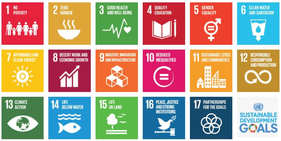
The convergence of Economy, Society, and Environment has resulted in a range of model sustainablity programs to unsustainable and devastating depletion of resources, e.g. potable drinking water, ozone in the atmosphere, and arable soil for agriculture. The United Nations Educational, Scientific, and Cultural Organization (UNESCO) provides educational materials, Education for Sustainable Development (Figure 5.2) to "empower everyone to make informed decisions in favour of environmental integrity, economic viability and a just society for present and future generations." (https://en.unesco.org/themes/education/sdgs/material [3]) These development goals are key elements of their 2030 Agenda for Sustainable Development.
Crisis Management
Crisis Management is the process by which an organization deals with a major event that threatens to harm the organization, its stakeholders, or the general public. Three elements are common to most definitions of crisis: (a) a threat to the organization, (b) the element of surprise, and (c) a short decision time. Usually, Crisis management involves dealing with events as they occur or right after they occur.
The need to develop information science and technology to support crisis management has never been more apparent. Crisis management, for events such as hurricanes, forest fires, disease outbreaks, chemical spills, and terrorist attacks, relies upon geospatial information about the event itself, its causes, the people and infrastructure affected, resources available to respond, and more. Geospatial data and tools are an essential part of all aspects of crisis management—from planning for future crises, through response and recovery, to the mitigation of a possible crisis. In all aspects of crisis management, geospatial data and tools have the potential to contribute to the saving of lives, the limitation of damage, and the reduction in the costs to and impact on society.
For example, responders who know where impacts are greatest, where critical assets are stored, or where infrastructure is likely to be damaged are able to act more quickly, especially during the “golden hour” immediately after the event when there is the greatest possibility of saving lives. Geospatial data collected and distributed rapidly in the form of useful products allows response to proceed without the confusion that often occurs in the absence of critically important information. Indeed, it is impossible to imagine the chaos that would result if first responders were entirely unfamiliar with an area and had none of the geospatial information—maps, GPS coordinates, images, human conditions and cultures, all essential to effective management.
Read:
With the above definitions setting context, skim the following, spending time on tables and flowcharts—notice the interplay between the two above topics.
- Disaster Risk and Site Selection [4], Dennis Donovan, 2002
- Murphy, Geography, Why It Matters, Ch.4 "Nature and Society" (pp.87-109)
- Ryerson, et. al., Why Where Matters, Sections 3.2.4, “Mapping On-Demand/Traditional Mapping”
- A Risk Management Standard, [5] published by the Federation of European Risk Management Associations
- Note: Pay special attention to graphics on page 4 (which shows examples of internal and external risks) and page 5 (which suggests a process for addressing risk.) You may find these two graphics, among others, helpful in sections 7.3-7.5.
- GIS Technology for Disasters and Emergency Management [6], Esri, Russ Johnson, 2000
The Geography: Why it Matters reading is from the required textbook for this course.
Registered students can access the other readings in Canvas on the Lesson 5 Readings page.
Do: Business Risk Management
Returning to the article on "Disaster Risk and Site Selection," consider risk minimization: How is site selection (essentially, location) tied to this take on dealing with disaster risks?
Deliverable
Post a comment in Canvas to the Lesson 5.1 - Risk Assessment forum including:
- one clear example of a risk to a business that experienced a critical disaster loss or damage, and
- how the business risk was minimized and what actions were taken to manage the crisis.
- You're welcome to post an additional example (from a different organization or scenario), if one comes to mind, for us to discuss.
Due Tuesday 11:59 pm (Eastern Time)
Check the calendar in Canvas for specific time frames and due dates.
5.2 Anti-Money Laundering (AML) and Counter Threat Finance (CTF) Investigations
Money laundering, terrorism, and threat financing present dangerous risks to businesses and the financial community. A business that does not establish procedures to identify and prevent money laundering or threat finance is at risk for financial losses, compliance violations, operational disruption, and reputational damage.
Financial Institutions (FI) evaluate the risks to their organization from exposure to AML/CTF. Similar to may other sectors, transactions represent the exchange of resources between parties. In finance, rules, laws, and guidelines regulate the terms and process of banking transactions. When criminal actors intend to violate the banking systems and established protocols, FI's and the public are at risk.
Compliance programs assess the threat of criminal activity, vulnerability of a business, and the potential risk to an organization. Financial services are required and/or expected to comply with laws such as the Bank Secrecy Act (BSA), regulations, policies, and International norms. The risk of ignoring or accommodating money laundering in a bank, financial institution, or money service business (MSB) can be catastrophic to a business. At the least, penalties such as fines, fees, or forfeitures, may impact the company’s bottom line. The volume of money laundering is estimated at $300B (USD) in illicit trade.[6]
What actions should a financial organziation take in finding, freezing, and forfeiting criminally derived income and assets? The main objective, in support of law enforcement action, is to break the ties between financial institutions (FIs) and criminals or traffickers, follow the flow of money through investigations, and uncover clients who act as producers, distributers, and beneficiaries in the illicit trade. It is not in the scope of this course to determine illegal activity. The purpose of the exercise is to model the use of location intelligence in AML/CTF investigations.
Basic understandings of AML/CTF, fraudulent transactions, and risk assessment are important for geospatial scientists and analysts working in the financial sector. Many elements of Know Your Customer involve geospatial relationships in place and time. The use of geospatial analysis and location intelligence tradecraft support FI and law enforcement investigations to identify suspicious activity. For additional context, one must understand that not all outlier events relate ot illegal money laundering activity or possible fraud. During the case study exercise, be on the lookout for false leads to test your hypotheses and analysis.
Money LaunderingMoney laundering is an attempt or action to conceal the origins of money obtained from illicit activities. It may also be referred to a a concealment of assets acquired legally or illegally intended for personal consumption or beneficial heirs. (OED 2002)
The U.S. Bank Secrecy Act (BSA) requires Anti-Money Laundering programs, oversight, and action to protect the public, safeguard the economy and financial systems, and refer suspicions of money laundering to authorities. On the financial side, AML is risk-based to identify types of customers, customer locations, and services a financial entity provides. Law enforcement, government regulatory, and public safety agencies conduct AML to investigate suspicions, follow the money, and defeat the ability of an individual, business, or organization to illegally launder money.
The Association of Certified Anti-Money Laundering Specialists (ACAMS) simplifies money laundering as the process of making dirty money look clean. ACAMS provides training, continuing education, seminars, and forums for Certified Anti-Money Laundering Specialists (CAMS certification), law enforcement, financial professionals, and investigators. www.acams.org [7]
Terrorism and threat financing
Terrorism is the unlawful use of intimidation and violence for political or ideological gains, often directed against civilians. There's a direct correlation between the level of activity of a terrorist group and their capability to acquire and move funds. Thus, the primary objective in countering terrorism is to cut off adversary's access to money. Counter Threat Finance (CTF) refers to govenment and Department of Defense action taken to deny, disrupt, destroy, or defeat threat finance systems and networks that negatively affect US interests. Threat finance refers to the methods used by organized criminal organizations or adversary groups to move and use funds to support their illegal activities or profit from them.
Stakeholders of CTF include entire sectors of the public safety (e.g. government, law enforcement, military) and financial community (e.g. private sector banks, insurance companies, mortgage lenders, money service businesses, law firms, accounting firms, real estate, auction houses).
CTF strategies are planned to disrupt an organization's illicit financial activity and counter criminal and terrorist groups' ability to fund and commit criminal plots. Major criminal activities that source adversary threat financing include black market operatons, illegal taxation, counterfeiting of all sorts, credit card fraud and identity theft, embezzlement or diversion of government funds, kidnapping, theft and sale of fuel.
Threat finance is how "bad guys make, hide, move, and spend their money," broadly relating to:
- terrorism
- narcotics
- human trafficking
- transnational criminal groups
- cyber-crimes
ACAMS describes Terrorist Financing as using funds for an illegal purpose, but the money is not necessarily derived from illicit proceeds. Readers may see similar references to Counter Threat Finance (CTF) and Combating the Financing of Terrorism (CFT); the context is equivalent yet specific actions may differ.
Know Your Customer (KYC)
The imperative to this entire process of strengthening the community's financial security is for FIs to Know Your Customer, or KYC, and verify client identities.
For the purpose of this lesson, we will now refer to money laundering as the target of geospatial analysts' work in AML/CTF investigations. Money laundering is certainly not only a 21st century problem and goes beyond stacks of U.S. $20's, Euro's, and Russian rubles. We must understand how criminals get their funding, where the money comes from, and what tactics are used to avoid detection.
FI's which unintentionally or intentionally launder money introduce similar risks to the financial sector as the criminal actors committing money laundering or threat financing. EU laws and directives hold supervisors and individual employees liable to imprisonment or fines if the FI is found to be assisting a money launderer. The principles of KYC and strict compliance of KYC procedures are designed and emplaced to reduce risks to the FI and employees.
Stages of Money Laundering
There are three distinct stages of Money Laundering:
- Placement of dirty money into financial institutions,
- Layering of those funds throughout the financial community, and
- Integration of laundered money with seemingly legitimate purchases.
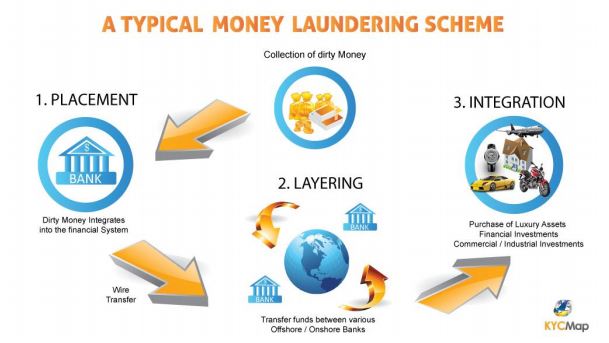
Figure 5.2 Typical Money Laundering Scheme, FINRA 2017
Investigators look for evidence of these three sequential events or activities in money laundering cases:
1. Placement is the physical movement of cash, currency or other funds to a place or other form which is less suspicious to law enforcement authorities and more convenient for criminals.
- Placement often takes the form of dividing illicit cash into small sums, making deposit transactions that fall below a Financial Institution (FI’s) regulatory reporting levels. Initial deposits of money into a FI is followed by layering the value of deposits into circulation through multiple FI’s, casinos, shops, bureau de change, other domestic or foreign businesses, and MSBs.
- The entire process is complicated by smuggling currency out of a country, the level of a bank's reporting complexity, currency exchanges, and foreign exchange markets.
- This represents the physical movement of currency and other funds to a place or other form which is less suspicious to law enforcement authorities and more convenient for criminals.
2. Layering involves further separation of the proceeds from their illegal source, using multiple financial transactions, networks linkage, and money flows.
- Electronic banking benefits the launderer, directly or subsequently transferring funds into a Bank secrecy haven (site) with lax reporting requirements. From there, it is common to see withdrawals in form of highly liquid monetary instruments, often money orders, traveler’s checks, and recently, cryptocurrency.
- Criminals distribute their money through wire transfers, purchase of insurance contracts or monetary instruments to obscure audit trails and hide proceeds; often using securities brokers and digital currency markets. High value transfers that may trigger suspicion are wire transfers, currency transactions, or spikes in sales of antiquities.
3. Integration is where illegal proceeds are converted into legitimate business earnings through normal financial or commercial operations; the movement of laundered money into the economy.
- Integration is the reinsertion of successfully laundered proceeds into a market by high value purchases, spending, investing, lending techniques, and legitimate Cross-border transactions. The funds often appear as normal business earnings.
- Layering and then integration changes the form of the proceeds from cash bundles to possessions of similar value; but less conspicuous. It’s not always cash that is reintegrated in the financial system and economy. High value purchases further disguise and launder dirty money proceeds. Classic asset purchases investigated are real estate property, artwork, coins and collectibles.
- Targets of money laundering may also include shell companies, business chains, insurance products, precious stones and jewelry, high value goods (e.g. performance or luxury cars), and antiquities.
Alerts to Suspicion of Money Laundering
Perpetrators of criminal acts strive to make the transactions as innocent-looking as possible. A suspicious activity report (SAR) or suspicious transaction report (STR) is filed by a financial institution to alert authorities of suspicious activity, known or suspected violations of BSA, and finance-related laws. Suspicious transaction detection is used to report banking transactions that may be connected with criminal activities.
When an AML/CTF case is referred for investigation or a geospatial analyst is involved, several types of events trigger alerts. Adverse media, such as a criminal investigation or international incident relating to a bank's customer, often initiates a review of that customer, accounts, and services the institution provides. For US transactions over the $10,000 threshold, a transacton monitoring system alert triggers a review of transfers to identify or rule out patterns of red flags for money laundering. FIs are required to evaluate risks of customers with multiple SARs and multi-layered account risks.
Investigation
What does an investigator look for? What differences appear from typical and atypical methods of money laundering? Where sources of funding are illegitimate, money laundering occurs to make the funds appear legitimate, to conceal its criminal origins.
The geographic issues raise questions:
- Where are the players?
- Where is what they want?
- Where can they get away with criminal activity?
Transactions - in finance and intelligence - represent relationships between entities. AML investigations start with finance customers, behaviors, reported or suspicious activity, and vast disjointed finacial data sets. These are the sources, recipients, conduits, unwitting facilitators, and indications for AML/CTF investigators.
- People
- Transaction data
- Financial institutions
- Correspondent banks
- Bridge-relationships
- Dates, times, transaction accounts and remittance records
Consider using the available financial transactions, credit card statements, bank records, tax documents, net worth analysis, andother open source or third-party geospatial information. From these spreadsheets, screens, and databases, the goal is to identify possible illicit activity, people involved, and to connect geospatial patterns of suspicious financial activity related to space and time.
Patterns of Money Laundering and Threat Financing
High value transactions take place at and through:
- Financial Institutions and banks
- Money service businesses, e.g. Western Union or MoneyGram
- Casinos
- Antiquity auctions
- Real estate markets
- Online digital currency exchanges, or cryptocurrency
- Mobile Money, M-transfers
- Online auction houses, e.g. EBay or Amazon
Read:
- Joshua Fruth. 2018. Anti-money laundering controls failing to detect terrorists, cartels, and sanctioned states [8]. Reuters. 14 Mar 2018. Online.
Skim:
- U.S. Treasury. 2018. National Money Laundering Risk Assessment [9].
- U.S. Treasury. 2018. National Terrorist Financing Risk Assessment [10].
Deliverable:
Ther are no Deliverables for 5.2.
5.3 Location Intelligence to Support AML/CTF Investigations
Role of Geospatial Analyst
The role of analysts to assess risks in AML/CTF investigations is based on the principle that a risk has two primary components of probability and impact. Determining the probability of money laundering or threat financing guides the method of descriptive, predictive, or prescriptive geospatial analysis. Investigating authorities determine the vulnerable parties, institutions, and communities at risk from suspicious illicit activity. Impacts of the risks vary in terms of cost, human safety, reputations, community order, and ethical business practices.
The geospatial analyst in AML/CTF investigations analyzes geospatial factors surrounding suspicious activity to identify risks, anomalies, and relationships through scientific process and discovery. Not all agencies or investigative teams include geospatial analysts; it depends on the agency, structure of investigative team, and an understanding of the advantage location intelligence provides an investigator over adversaries or suspicious groups.
The geospatial analyst links unusual financial transactions to data on people and businesses in geographic locations. Let us reiterate for this course that the geospatial analyst is not a legal authority, does not determine suspicion of activity, nor identify parties as conducting illicit or legal financial transactions. We are teaching methods of geospatial analysis in support of investigations to identify anomalies, patterns in geospatial and business information, and risks to proximal institutions or places.
Geospatial analysts work on location-based problems, questions, and search for patterns. Their role for Finance is to use geospatial analysis tradecraft to provide location intelligence to clear ambiguity of where transactions meet regulatory or slip under thresholds. Investigators respect rights to privacy and societal responsibilities. This is an ethical issue for analysts to "stay in their lane", know and follow guidelines of the financial organization, investigatory agency, and role.
Advantage of Location Intelligence
Location intelligence can be described as the practice of collecting, enriching, and analyzing business information, georeferenced data, and geospatial information to discover contextual insights for location-based challenges or opportunities. The process of location intelligence is conducted confidentially to gain a decision advantage for the organization or to disadvantage competitors.
Assessing the human dimension in AML/CTF is difficult and requires behavioral knowledge, training, and experience; not typically a forte of geographers (except advanced human geography). Including a geospatial analyst in an investigative team adds a highly specialized skillset in location intelligence to work collectively towards uncovering illegal activity. There are significant elements of these investigations which are not released outside of the AML/CTF community, with good reason. To reiterate, the purpose of introducing AML and CTF investigations in Lessons 5 & 6 is to share additional methods of geospatial analysis and career options for your personal development.
Uses of location intelligence in AML/CTF investigations are to:
- identify possible illicit activity and persons involved through geospatial modeling;
- connect geospatial patterns of suspicious financial activity related to place and time;
- assess growth, direction, volume, and potential for money laundering; and
- identify network connections related to location and electronic banking linkage.
Asking business questions to organize the analysis workflow.
What can the geospatial analysis and geospatial intelligence communities do to help Finance mitigate the threats they face? The geospatial analyst's role is defined by the requirements of the organization. Following an organized approach to the inquiry, the analyst starts with asking pertinet questions, gathering data, and cerating GIS models. The organization determines the specific goals of the analysis, such as to:
- Discover patterns of money laundering
- Assist FIs to "know their customers"
- Comply with national and international practices
Geospatial analytics improves the accuracy of risk assessments and reduces the time to identify suspicious activity. AML/CTF is yet one more use case of geospatial analytics to solve a complex problem. Location intelligence and geospatial intelligence adds a previously unappreciated decision advantage to anti-money laundering and counter threat finance investigations. Geospatial analytics integrates the business segments of customers, financial institutions, and transactions to detect banking anomalies. We're combining geospatial information, analytical modeling, remote sensing where it fits, artificial intelligence (AI) and machine learning in proven workflows.
Transactions
Transactions provide us the first introduction to entities and represent relationships between entiites. These are exchanges of resources, as physical transactions that occur primarily in physical space, the real world, and as logical transactions conducted in cyberspace. Geospatial analysts examine transactions to connect entities and locations. Critical metadata of spatial and temporal registration define events and transactions in space and time.
Spatial registration describes attributes of event data and temporal registration defines transaction data. All transactions have a precise beginning and end. However, one should be aware of FI rules that determine the timing and availability of funds in wire tranfers, deposits, lending arrangements, and withdrawals.
Analysis to produce location intelligence.
AML/CTF investigations leverage GIS, link analysis, and geospatial analysis to determine which FIs are most at risk to exposure of illicit finance. Intial research links unusual financial transactions to data on individuals in geographic locations.
Geospatial predictive and prescriptive models improve the accuracy of risk assessments and can reduce time to identify suspicious activity. A core skill in producing location intelligence is designing a workflow specific to the problem:
-
Define the situation and business question.
-
Identify the deliverables needed to support a decision.
-
Identify, collect, organize, and georeference data needed to examine the problem.
-
Follow an investigative and geospatial analytical process to:
-
Discover and uncover patterns and relationships
-
Rule out false leads (not actually suspicious behavior)
-
Identify threads for further research and analysis
-
-
Discuss a predictive or prescriptive workflow which supports the investigation objectives.
-
Map, chart, visualize, and summarize your observations, presentation of findings or recommendations
The expected result of this analysis workflow in AML/CTF investigations is to:
- create geospatial models to identify and visualize patterns, risk areas, and corrdors, and
- identify regions likely exposed to the flow of illicit funds, potential funding streams, and risks to nearby FIs.
Predictive & Prescriptive Analytics of Financial Fraud
Data analytics involve processes of inspecting data and to correlate the volumes of Big Data into useful information. In money laundering investigations, certain types of digital analysis may be used to isolate patterns of fraudulent activity. Analysis techniques include graph mining to detect suspicious transactions or spatial data mining to identify geographic patterns. For smaller data sets, commercial database and spreadsheet packages adequately support data analytics.
Predictive geospatial analysis estimates the likelihood of future events, of a similar event occuring in a different location under congruent circumstances. Predictive analytics applies forecasting to statistical models to understand, "What could happen?"
Prescriptive analytics combines outcome optimization and statistical simulations to develop courses of action. This form of geospatial analysis provides choices of actions or solutions for decision makers answering, "What should happen; what should we do?"
Geographic, Financial, and Security Data
When does an analyst have all the required, relevant, and georeferenced data at the start of analysis? So much effort is expended to collect and enrich data; internal data, open source, third-party, civil, and gained through observations. Raw financial data may additionally be obtained from individuals, FI databases, service providers, and MSB or Informal Value Transfer Services (IVTS).
It may be possible, with proper authorizations, to access financial data collected in commercial sector databases, e.g. retail outlets, supermarket chains, loyalty programs, telecommunication, insurance, financing, airlines, utility, car service, and deliverly companies.
Presentations to reach decisions, inform leaders, brief an investigation team
Communicating the location intelligence results of an AML/CTF investigation impact comprehension, resolving competing theories, and visualizing the geographic information. The analyst may present findings for actionable decision, to alert authorities, or referral for additional or other forms of analysis. There's no single, optimal format for presentation, this is a key competency to learn. Presentation techniques and tools depend on the organization, objectives, and decision maker preferences. Formats and geospatial information often:
- Map, visualize, chart findings to depict patterns, relationships, situational awareness
- Provide intelligence and feedback to stakeholders
- Perform descriptive, real time, predictive or prescriptive analysis (what happened, is happening, may happen, or should happen?)
- Present for action, decision making
Read:
Wakeman, Exploring Potential Uses of Geographic Information Systems and Predictive Analysis in AML/CTF Investigations [11].
Registered students can access the reading in Canvas on the Lesson 5 readings page.
Deliverables:
There are no deliverables for 5.3.
5.4 Case Study: Location Intelligence to Support AML/CTF Investigations, Part 1
You will work individually on the AML/CTF Case Study in Lessons 5 & 6. However, you may collaborate, discuss, ask & answer questions in the Discussion Forums for both lessons.
Case Study: Location Intelligence to Support AML/CTF Investigations,
Part 1 - Placement and Layering
1. This is a case study to expand your understanding of location intelligence, AML/CTF investigations, chosing and applying various geospatial analysis methods to detect anomalies and patterns, and making recommendations on the next steps of the AML/CTF investigation.
a. Follow the financial trail of a hypothetical, fictional college student over 18 months of his freshman year, summer, and sophomore year. The story starts that multiple suspicious activity reports (SARs) have been filed on this person of interest. The initial SAR was filed by a local bank, second SAR used his Dad's name and the report was dismissed, and the third was serious to include international wire transfers.
b. Blake Glover (fictional character) began freshman year as a resident college student, started making money with a summer job, and opened a credit card. Then, he deposited more money, transferred funds around, and the financial trail gets more complicated.
c. How does one use GIS in AML/CTF investigations? What does an investigator look for in AML/CTF? e.g. what patterns do they look for, why care about an individual's banking practices?
2. Multiple SARs have converged on a suspicion of money laundering and possible illicit activity with Blake Glover. The investigation team "reads you in" on the situation to produce location intelligence to support the AML/CTF investigation. SARs are highly confidential and we can't release the specifics of the initial SAR, submitted when a FI clerk expressed concern over repeat transactions at their State College branch.
a. Look at repeat deposits with an eye toward space and time; location and frequency of deposits.
b. A summary of the SAR circumstance on Blake Gover is available through Canvas, Lesson 5.4.
c. In response to the inquiry, banks produced transaction reports for you to start a geospatial analysis, e.g. credit card transactions, new bank transactions, information regarding multiple cash deposits.
d. Integral to BSA compliance is for a Financial Institution (FI) to Know Your Customer (KYC):
-
What do you know about the [your] customer of interest?
-
What financial services are/were provided to this customer?
-
What do you want to find out?
-
What do you request? Other reports can be pulled.
3. As the geospatial analyst assigned to develop location intelligence in support of this AML/CTF investigation, you now have access to transaction reports, credit card statements, and an awareness of casino transaction report (CTR) and SAR.
a. Review the structured and unstructured datases. Organize the data to identify normal, consistent transactions; anomalies; and financial patterns suggestive of money laundering.
b. Select and use analysis tool(s) to demonstrate your ability to analyze geospatial data, categorize and quantify financial data, and visualize patterns. In a descriptive analysis, produce insights into the past - Blake Glover's activities tied to the SARs and AML/CTF investigation.
c. Examine the financial and geospatial information to identify and categorize, if applicable, transactions and patterns of the first two elements of money laundering (placement and layering).
d. Provide location intelligence and feedback to stakeholders. What to do with results of analysis? Map, visualize, chart to depict patterns, relationships, situational awareness with an executive summary. Consider your busy investigative team; keep your slides informative, visual, and brief.
Case Study: Step 1 - Placement
- Review Placement, what do you note about the transactions?
- What patterns emerge from your analysis of the student's financial transactions, purchases, deposits, or geographic connections?
Case Study: Step 2 - Layering
- Review Layering, what do you learn from the transaction reports and activity?
- Do the student's behaviors or financial trail suggest a flow of illicit funds or corridor(s)?
Deliverable:
Complete the Money Laundering Placement and Layering activity; submit an Initial Presentation of your analysis (sequence of slides/images/maps/reports with your comments annotating the presentation) and an Initial Written Report (about 2 pages, Word document).
1) Create a Powerpoint Presentation of your Transaction Analysis. Approximately five slides will cover the concepts of Placement & Layering. Please include the following in your PowerPoint Presentation and post it in the Lesson 5.4 Activity Case Study: Location Intelligence for AML/CTF Investigations, Steps 1 and 2 drop box. Any cover page slides or reference slides do not count towards a suggested number of slides in a presentation.
- Maps or other visualizations of the investigation area of interest, locations where money was placed (initial step of laundering) area with any relevant polygon and point layers visible and symbolized.
- Financial & geospatial information which evidence the results of your analysis and address the elements of Placement and Layering. NOTE: You may wish to clip the report to highlight elements you wish to be clearly visible in your presentation.
- Brief explanation/rationale for your suggestions as commentary to your images.
2) As your Individual work, write a 2-page Report summarizing your findings of Placement and Layering.
- Support or refute that Glover's financial actiivity and behaviors suggest Money Laundering. What patterns of Placement and Layering do you identify?
- Include maps, figures, charts, or graphs to support your findings and argument. These may be from the transaction analysis or visualizations of the data which you create.
Your grade will be based how well you make your case both in terms of evidence and presentation.
Due Tuesday 11:59 pm (Eastern Time)
5.5 Term Project – Continue Working
You have a full week of learning and case study deliverables, so I did not assisgn Peer Feedback in this Lesson.
(For future feedback activities): To provide meaningful feedback, you should consider the following aspects:
- Are the goals reasonable and achievable? It is a common mistake to aim too high and attempt to do too much. Suggest possible amendments to the proposals' aims that might make them more achievable in the time frame.
- Are the data adequate for the task proposed? Do you foresee problems in obtaining or organizing the data? Suggest how these problems could be avoided.
- Are the proposed analysis methods appropriate? Suggest alternative methods or enhancements to the proposed methods that would also help.
- Provide any additional input that you feel is appropriate. This could include suggestions for additional outputs (e.g., maps) not specifically mentioned by the author, or suggestions as to further data sources, relevant things to read, relevant other examples to look at, and so on.
No Deliverable for this Lesson 5.5:
There are no deliverables for your own term project this week.