Unit 2: Making Mountains and Earthquakes
Welcome to Unit 2
Plate Tectonics I: Making Mountains and Earthquakes
.gif)
“If they’d lower the taxes and get rid of the smog and clean up the traffic mess, I really believe I’d settle here until the next earthquake.”
— Groucho Marx, about Los Angeles, California
“We learn geology the morning after the earthquake.”
—Ralph Waldo Emerson
“It’s snowing still,” said Eeyore gloomily. “So it is.” “And freezing.” “Is it?” “Yes,” said Eeyore. “However,” he said, brightening up a little, “we haven’t had an earthquake lately.”
—A.A. Milne, The House at Pooh Corner
As you may recall in the beloved Christmas special about Rudolph, at a key point in the story, Yukon Cornelius hacks off a chunk of sea ice—frozen ocean water—so that he, Rudolph, and Hermey the dentist elf can drift away over the ocean and escape from the Abominable Snowman. If you've ever neglected to check the spaghetti sauce you were heating on the stove while watching Rudolph because you were just dying to know whether 'Bumbles bounce', you may have noticed that the stiff scum that forms on top can break into chunks and drift around on the liquid beneath—much like Yukon C's ice block.
In this unit, and the next two, we'll explore the equivalent activity in the Earth, with the hard-frozen upper layer breaking into drifting chunks, melted lava leaking up in cracks to feed volcanoes (vaguely like the water in the crack that the Bumble fell into when trying to catch the heroes), collisions causing earthquakes when blocks run together ("Land, Ho"), and more. Hold onto your teeth, and let's get started for the land of misfit plate boundaries.
Learning Objectives
- Explain the characteristics of the three major plate boundary types: pull-apart, push together, and slide-past faults and the role each plays in the formation of landforms, the ocean floor, and the spreading of the West.
- Differentiate between radiation, conduction, and convection and their roles in mountain making and earthquakes.
- Explain the relationship between Death Valley and the Gulf of California.
- Demonstrate an understanding of Elastic Rebound Theory
- Describe plate tectonics.
- Differentiate between P and S seismic waves and their behaviors.
- Demonstrate an understanding of the Richter scale and earthquake intensity.
- Differentiate between the layers of the Earth (lithosphere, mantle, outer core, inner core) and their characteristics.
- Recognize the factors and pitfalls that go into the prediction of earthquakes.
What to do for Unit 2?
You will have one week to complete Unit 2. See the course calendar for specific due dates.
As you work your way through the online materials for Unit 2, you will encounter a video lecture, several vTrips, some animated diagrams (called GeoMations and GeoClips), additional reading assignments, a practice quiz, a "RockOn" quiz, and a "StudentsSpeak" Survey. The chart below provides an overview of the requirements for this unit.
| REQUIREMENTS | SUBMITTED FOR GRADING? |
|---|---|
|
Read/view all of the instructional materials |
No, but you will be tested on all the materials. |
| Continue working on Exercise #1: Scientific Literature | Yes, this is the first of 6 Exercises and is worth 5% of your total grade. |
| Take the Unit 2 "RockOn" quiz | Yes, this is the second of 12 end-of-unit RockOn quizzes and is worth 4.5% of your total grade. |
| Complete the "StudentsSpeak #3" survey | Yes, this is the third of 12 weekly surveys and is worth 1% of your total grade. |
Questions?
If you have any questions, please feel free to email "All Teachers" and "All Teaching Assistants through Canvas conversations.
Keep Reading!
On the following pages, you will find all of the information you need to successfully complete Unit 2, including the online textbook, a video lecture, several vTrips and animations, and two overview presentations.
Students who register for this Penn State course gain access to assignment and instructor feedback, and earn academic credit. Information about registering for this course is available from the Office of the University Registrar.
Main Topics, Unit 2
Overview of the main topics you will encounter in Unit 2
THE EARTH: It's HOT Inside!
- The deeper a mine or oil well is, the hotter it is at the bottom; volcanoes bring up heat from below.
- Most of the Earth’s heat is made by the decay of natural radioactive atoms in rocks.
- How materials (and people!) behave depends on what they are (iron, silica, etc.) and on the conditions they are placed in (heat, pressure).
THE EARTH: Layered by Composition & Behavior
- Iron core, mantle with silica added to iron, ocean crust with more silica, continental crust with still more silica (way more complex than this, but this is a start)—going up, each layer less dense and floats on layers below, except cold, old ocean crust can sink into hot mantle.
- Core has a solid inner part (higher pressure squeezes to solid) and a liquid outer part.
- Crust plus upper mantle (called lithosphere) tend to break, not flow; deeper in mantle tends to flow not break (asthenosphere, plus other names and layers we won’t worry about) (hot solids can flow—think of chocolate bar in your pocket, or blacksmith making horseshoes).
- Mantle and crust solid, but with a little melt in a few places.
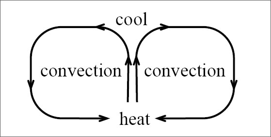
CONVECTION: Moving the Mantle's Heat
- Heating causes expansion & rising, and cooling causes contraction & sinking; together forms convection cells (in spaghetti pots on the stove, and in soft parts of Earth’s mantle).
- The lithosphere is broken into a few big plates that raft around on the convection cells like scum on a spaghetti pot.
- Where the lithospheric plates are pulled apart, they tend to break. Breaks, in places such as Death Valley, often are angled rather than vertical, and one side slides down along the other, making an earthquake fault.
- Death Valley is a great example of the effects of convection!
NEVADA GETTING WIDER (with Death Valley)
- Lake Tahoe (California) and Snowbird (Utah) ski areas are moving apart about as rapidly as your fingernails grow (an inch or so per year)—can measure with GPS, etc.
- This has offset layers of rock across earthquake faults, and earthquakes still happen and increase that offset.
- Lava may leak up the faults to feed volcanoes.
- If this kept on, could tear the west apart to make an ocean basin.
DEATH VALLEY: Tear-Apart Makes Oceans
- The Gulf of California was formed by spreading, tearing Mexico apart.
- Baja California is drifting away from the mainland.
- The breaking of the rocks has focused along a crack down the middle of the Gulf.
- As the rocks move away from the crack, their weight no longer squeezes the hot mantle beneath the crack.
- For most rocks, squeezing tends to make solid, and “unsqueezing” (a drop in pressure) favors melting.
- So, the hot mantle under the crack melts a little, and the melt leaks up the crack and freezes.
- The sea floor of the Gulf of California (and of all other oceans!) is made of frozen crack-filling lava.
- The sea floor is hottest, and thus highest in elevation, near the crack, forming a mid-oceanic ridge.
- Such ridges wind through Earth’s oceans like the seam on a baseball.
- Ocean-floor rocks are youngest near the ridges and oldest farthest from the ridges.
- Sediment (wind-blown dust, fish poop, etc.) is thicker away from the ridges because older rocks have had more time for fish to poop on them.
- Where ridges come up on land, they are ripping continents apart, as at Death Valley and in the East African rifts.
EARTHQUAKES!
- Ground shaking from any cause.
- Few big, deep ones may be from pressure squeezing minerals to a new, smaller form.
- Most earthquakes happen when one batch of rocks moving past another batch gets stuck for a while, bends, then breaks loose, and the bend snaps back like a broken rubber band.
- The break between the two batches of rocks is called a fault, or an earthquake fault.
EARTHQUAKE: Seismic Waves
- During an earthquake, rocks shake neighbors, which shake neighbors, making waves moving away from the quake.
- P (or push) waves are normal sound waves and go through solid, liquid, or gas.
- S (or shear) waves are slower, and don’t go through liquids (know Earth’s outer core is known to be liquid because P but not S waves go through).
- Seismic waves shake buildings and may knock them down.
EARTHQUAKE SIZE
- An increase of 1 in Richter magnitude means an increase of 10 in ground motion, and an increase of 30 in total energy (a magnitude-3 quake moves the ground 10 times more than a magnitude-2 quake, which moves the ground 10 times more than a magnitude-1 quake).
- Can just feel a magnitude-1 quake, magnitude-5 damages buildings, biggest (about magnitude-9) is far bigger than atomic bombs.
EARTHQUAKE OCCURRENCES
- For each increase of 1 in magnitude, quakes become about 10 times less common.
- But because the increase of 1 in magnitude means an increase of about 30 in energy, most energy is released (and most damage) in few, big, rare quakes.
- Quakes occur especially where big blocks of rock are moving past each other.
- Not many in Pennsylvania, and other central regions of lithospheric plates; mostly near plate edges.
EARTHQUAKE DAMAGE
- Can be HUGE (worst ever estimated to have killed 800,000 people, in China in 1556).
- We can predict where big quakes are likely.
- Can’t (yet) predict whether a quake is about to happen.
- Maybe rocks give hints they’re about to break, but not sure.
Textbook 2.1: Plate Tectonics 1, Death Valley
Death Valley is Growing Wider: Death Valley and Sea-Floor Spreading
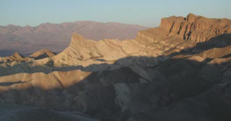
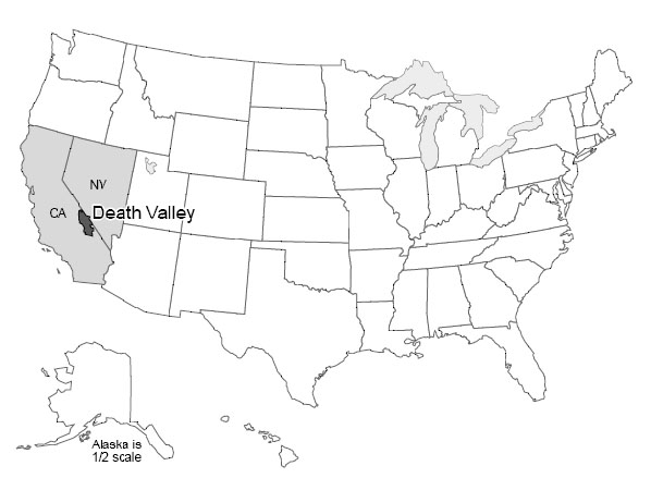
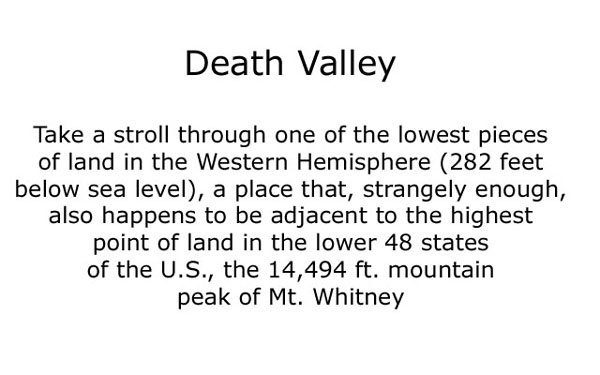
Death Valley National Park of California and adjacent Nevada sits as deep as 282 feet below sea level near Badwater, the lowest land in the western hemisphere. Yet, Telescope Peak in the Panamint Range, 11,049 feet high, is in the park less than 20 miles west of Badwater, and Mt. Whitney, at 14,494 feet the highest peak in the continental United States, is only about 80 miles away.
Death Valley is the hottest, driest place in the United States. On July 10, 1913, the temperature reached 134oF (57oC), and 125oF is common. All of the rainfall (about 2 inches or 5 cm per year) evaporates quickly.
Occasionally, water will sit on mud flats for a while (especially in the colder winter) before evaporating to leave salt deposits. Sometimes in winter, the water freezes on top, and strong winds blow the ice, dragging rocks that are frozen in it. The tracks of such rocks, at the Devil’s Race Track, long puzzled people before the answer was discovered. (And you’ll still find people who argue about the tracks and rocks out on the flat surface—no one has ever watched the rocks when they were moving!) During the ice age, more rain and cooler temperatures than today caused the valley to fill with water, forming Lake Manly, which was about 90 miles (150 km) long and almost 600 feet (200 m) deep at its deepest.
Salts left on mud flats by evaporating waters often contain boron, a rare element that has leached from volcanic rocks nearby and been carried into the valley by streams. Boron is used in soaps, water softeners, pottery glazes, and other things. Mining of the boron-bearing borax salts began in the early 1880s, and they were hauled out by the famous 20-mule teams. Mining was allowed to continue in the park after it was established (as a national monument in 1933, and a national park in 1994), but is being phased out. Copper, gold, silver, lead, and talc has been mined in or near the park.
Pull-Apart Faults
The great depth of Death Valley was not carved by a river or glacier or the wind, and is not from a cave-like Mammoth Cave collapsing. Instead, as shown in the diagram below, labeled Pull-apart fault at Death Valley (which is more-or-less what you would see if you could take a slice across the valley from the air at the top down into the Earth at the bottom), Death Valley has been dropped along faults as the region has been pulled apart. Similar down-dropped and upraised blocks extend across much of Utah, Nevada, and neighboring areas, forming the Basin and Range region. A little bit of such faulting even extends up into Wyoming, and the great front of the Teton Range is geologically a close cousin to the west side of Death Valley.
The geologic evidence of faulting is clear—layers of rock and even recent stream deposits are offset across the faults, as you'll see in a VTrip at the end of this unit. The faulting occurs in fits and starts rather than smoothly, producing earthquakes. The Basin and Range regions remain active in producing earthquakes. (More about earthquakes is coming soon.)
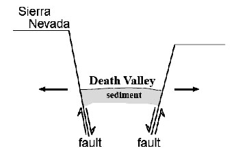
Because of the way that the faults are angled, the dropping of blocks requires that the region is getting wider! (Look again at the diagram to the right labeled Pull-apart fault at Death Valley.) It has recently become possible to measure this widening using GPS or very-long-baseline-interferometry techniques. The widening is not fast—maybe an inch or two (a few centimeters) per year across the whole Basin and Range—but the widening is occurring.
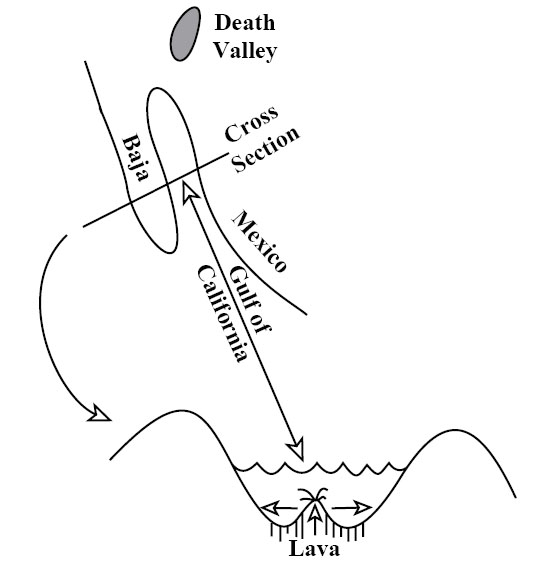
Go south from Death Valley and you will splash into the Gulf of California. The geologic record shows that all of Baja California was attached to the main part of Mexico, but has been moved out to create the Gulf, and is still moving out. Eventually, the Gulf may extend up into Death Valley as the spreading continues and the west “unzips,” although the unzipping may stop before the whole west is opened up (see figure below — Pull-apart fault in the Gulf of California).
Next, boat across the Gulf with a depth-finder running, and you will see that there is a ridge down the middle of the Gulf. Get in your submarine and dive on that ridge, and you will find that it is a volcano. Lava leaks up along a crack in the middle of this ridge volcano, hardens, and then moves slowly away as new lava leaks up along the crack. Interestingly, lava also leaks into Death Valley along its faults, with eruptions within the last 200 to 300 years.
Sea-Floor Spreading
Next, follow this ridge volcano south. You will find that it runs into the open Pacific Ocean and then wraps around the globe through all of the world’s oceans, like the seam on a baseball. The ridge runs right up through the middle of the Atlantic (coming to the surface in Iceland). (Because the ridge is in the middle of the Atlantic, and the middle of the Gulf of Mexico, and the middles of some other ocean basins, it is often called a mid-oceanic ridge, although in some places the ridge is most assuredly not in the middle of the ocean.) Study the seafloor, and you will see that it is made of rocks that are young—they hardened as the lava cooled recently—near the ridge, with older rocks—they hardened as the lava cooled a long time ago—as you move away in either direction. We will discuss how we learn the ages of rocks later; for now, please accept that the rocks, and the sediments just above the rocks, are progressively older with increasing distance from the ridge.
Everywhere we meet the ridge, it is shallow and hot. The rocks that form at its volcano slowly cool as they move away, contracting and sinking. The ridge is a bizarre place in many ways—water circulates through cracks in the hot rocks, dissolves many chemicals in the rocks, and emerges as “black smokers” where the minerals reprecipitate or “rainout” in the colder ocean as a sort of black dust or as a cone around the emerging water. Many valuable ore deposits were originally formed from the chemical precipitates around these black smokers. An entire ecosystem of tube worms, clams, etc., lives on bacteria that use these chemicals for a fuel source, rather than relying on the Sun for energy, as do most living things.
Heat Inside the Earth
We just discussed a lot of observations—a baseball-seam volcano through all the world’s oceans that is making seafloor and splitting and spreading continents and ocean basins. Explaining these observations will tell us much about the Earth and how it works.
The existence of volcanoes, bringing melted rock up from below, tells us that the Earth is hotter inside than at the surface. We learn the same in deep mines and drill holes—the Earth is warmer towards the center (once you get below the top thirty feet or so that are warmed a little by the summer and cooled by the winter). All rocks contain radioactive elements (mostly uranium, thorium, and radioactive potassium, but with some others). Radioactive decay of these makes heat in the Earth, much as radioactivity produces heat in nuclear power plants. Most of the Earth’s heat comes from this radioactive decay, although some heat is left over from when the Earth formed, or is being released as the core freezes, or the core, mantle, and crust continue to separate and things sink and give up heat from friction.
Heat is just the vibration of the atoms from which everything is made. More heat causes more vibration. Temperature is a measure of these vibrations; more vibration gives a higher temperature.
Heat is moved around in three main ways: radiation, conduction, and convection. Vibrating atoms give off electromagnetic radiation. The electromagnetic radiation that comes from very hot atoms is visible to us and is called light; cooler atoms give off infrared or other electromagnetic radiation we cannot see. When an atom gives off electromagnetic radiation, the atom cools and slows down, unless it receives other energy to speed it up again. You soak up electromagnetic radiation if you lie out in the sun (and may get skin cancer as it damages the DNA in your skin), and you can feel electromagnetic radiation if you hold your hand off to one side of a hot stove burner. Electromagnetic radiation is a very efficient way to move heat from the sun to the Earth through space and our atmosphere, but radiation is a very inefficient way to move heat through rocks—the radiation doesn’t get very far before it is absorbed. (Thus, you cannot see far through most rocks.)
If a rapidly vibrating atom (a hot one) sits next to a slowly vibrating atom (a cold one), collisions between the two will tend to slow down the fast one and speed up the slow one. This process is called conduction and moves heat energy from atom to atom. Conduction is a very rapid process over short distances. (If you foolishly touch a hot stove burner, you will almost instantly realize how quickly it makes the atoms in your skin vibrate rapidly, and how much damage can be done if they vibrate too rapidly and jump out of those places where they are supposed to be in your skin.) Conduction is a very slow process over long distances. Think of standing in a line of 1000 people. If you push your neighbor, the response is almost immediate. But if you wish to disturb someone at the other end of the line, pushing your neighbor who pushes her neighbor who pushes his neighbor... it becomes very inefficient. For the Earth, the distance from the center to the surface is about 10,000,000,000,000,000 atoms. The Earth is not old enough for heat trapped at its center when it formed to have been conducted to the surface.
Convection is the third option for moving heat. Take something hot, and move it from here to there. To get heat from the stove to your dinner table, you cook things on the stove and then carry them to the table, which is much more efficient than putting the food on the table and waiting for conduction or radiation to bring heat from the stove.
Nature has a special way to arrange this motion in many things. Heating causes almost all materials to expand because hotter molecules vibrate more rapidly and tend to bounce farther away from each other. This lowers the density of the material; its mass is the same, but it takes up more room. Low-density materials tend to rise, and high-density materials tend to sink. This leads to convection currents—a material is heated, rises, cools, and sinks. Typically, rising occurs in one place, the material flows along while it cools, then it sinks and flows back to the rising point (see the convection figure above). (Technically, moving heat by rising of materials that expanded when they were heated is called “convection,” and moving heat by transferring hot materials in other ways is called “advection,” but introductory texts usually call it all “convection.”) You should have seen the effects of convection currents in the air (we’ll talk about them later, but they produce wind, rain, etc.), and in the boiling water of a pot of spaghetti on the stove. We believe that convection currents occur in the Earth as well. This may seem odd at first because most of the Earth is solid rather than liquid. (Volcanoes come from a depth where there is a little bit of liquid, but even there most of the rock is solid.) However, sufficiently hot rocks are soft enough to flow slowly. Again, we will discuss this later, but it is the same principle that allows a blacksmith to work hot iron into horseshoes, or allows a chocolate bar to droop on a hot day.
Our modern picture of the Earth, then, is that it is heated inside, mostly by radioactivity. That heat cannot escape easily by radiation or conduction. When the Earth was young, the heat stayed in and warmed the planet. When the rocks became hot enough, they began to convect. The planet probably melted completely and convected vigorously, followed by solidification that slowed but did not stop the convection.
In convection, the hotter rocks rise and then spread. Rising occurs beneath the ridges in the oceans. There, the new seafloor is made and then rafted away on the spreading convection cells. Where a spreading zone passes under a continent, the continent is thinned and stretched and may be torn apart to make a new ocean. This is occurring under East Africa in the rift valleys, and in the Basin and Range of the western United States—including Death Valley—and occurred to open the Gulf of California, moving Baja away from the mainland. (There may be convection cells stacked on top of each other in the mantle, and other complexities—if we tried to cover all of the wonderful complexity in an introductory course, some of you would be overjoyed but many of you would be unhappy—but this is a good start.)
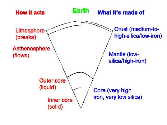
The Earth is layered chemically into a medium-to-high-silica crust, a low-silica mantle, and an iron core (well, there’s a good bit of nickel in the core, too). The Earth is also layered based on its ability to flow rather than break (see the Cross section of the Earth figure on the right). The lithosphere includes the crust and upper mantle. The lithosphere can flow a little in some places but usually breaks rather than flowing if you hit it or squeeze it or pull it with sufficient vigor. Below the lithosphere, the asthenosphere is that part of the mantle that flows rather than breaking, and from which many spreading-ridge volcanoes come. The topmost layer of the mantle is the bottom part of the breaks-rather-than-flows lithosphere. Below this in the mantle is the flows-rather-than-breaks asthenosphere, and then other layers that also flow rather than break, and that we don’t make you learn. And the core has a liquid outer part and a solid inner part.
The lithosphere is broken into a few basic pieces called plates. These float around on the convecting, soft asthenosphere. A plate may include just continental rocks, or just sea floor, or some of each. A plate map is given in chapter 3, in section 3.2 on Olympic National Park. The study of these plates and how they move and interact with each other is called “plate tectonics.”
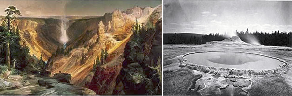
Textbook 2.2: Plate Tectonics 1, Yellowstone
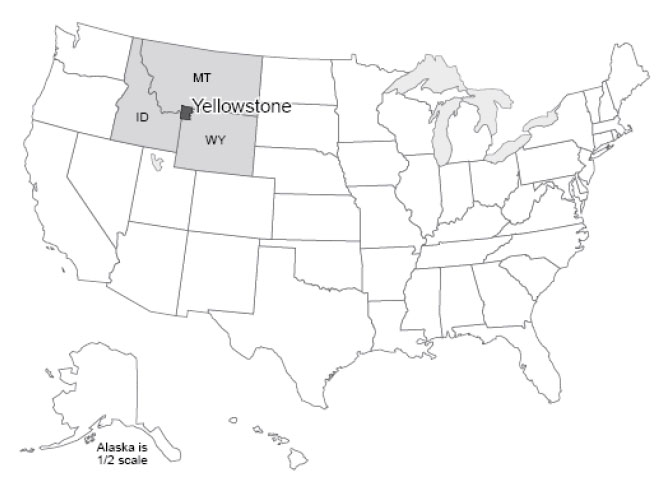
Yellowstone is Shaking - Real-world Applications: Yellowstone and Earthquakes
Yellowstone: for many people, the name is synonymous with national parks. Yellowstone was the first national park, for a while it was the biggest (at approximately 60 miles by 60 miles—100 km by 100 km—it is still a big one), and it is widely considered to be the best. You could probably identify a dozen features or more that, separately, would merit protection by a national park. The Grand Canyon of the Yellowstone is a great chasm cut through volcanic rocks that have been “cooked” by hot water and steam circulating through them, in the process gaining the yellow color that gave the park its name. The Canyon contains two large waterfalls (rather unimaginatively called the Upper and Lower Falls), where the river plunges over more-resistant rocks. Mammoth Hot Springs is a mountain being turned inside-out, with acidic hot-spring waters dissolving caves underground, bringing the dissolved limestone to the surface, and depositing some of it as gleaming terraces. Specimen Ridge is home to at least 20 petrified forests complete with petrified roots, standing one on top of the other, from roughly 40 million years ago. Volcanic ash and debris flow buried the standing trees, and chemical reactions caused the silica in the ash to move into the wood, replacing it (a subject for much later in the course). A new forest grew and was buried, and this was repeated 20 or more times.
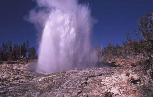
The biggest draws at Yellowstone are the thermal features. Various lines of evidence indicate that there is a body of melted rock (magma) under the park, now up towards the northeast side. The rocks under most of the park are anomalously hot at shallow depth. In addition, the park receives abundant rainfall and snowfall. The water from rain and melted snow circulate deeply through rocks broken by numerous earthquakes, and the water is heated from below. In some places, the water is heated all the way to steam, which emerges from holes known as fumaroles. In other places, hot water bubbles to the surface in beautiful springs. If the bubbling action mixes in enough mud, then paint pots, mud pots or mud volcanoes develop.
Sometimes, cold water on top holds hot water down, with the pressure preventing the boiling of the hot water in a pressure-cooker effect. Eventually, a little boiling manages to expel a little of the water above, reducing the pressure, allowing more boiling, and a geyser erupts. Geysers require heat, water, and a tight, tough plumbing system to hold the hot water and withstand the high pressures. The volcanic rocks of Yellowstone are rich in silica, which is dissolved and re-precipitated by the hot waters to seal cracks in the rocks, helping produce geysers. Perhaps half of the world’s geysers are in Yellowstone, including the largest and most spectacular ones. Yellowstone also is noted for many waterfalls besides those in the Canyon, for a number of other interesting features, and for abundant wildlife, which we'll visit later in the course.
Yellowstone itself is centered on the Yellowstone Caldera, a collapse feature related to three great volcanic eruptions, or periods of eruptions. The caldera, roughly 50 x 30 miles (80 x 50 km), includes Yellowstone Lake but extends well beyond it. (No lake in the nation is both higher and larger than Yellowstone Lake, yet it is only a piece of the caldera.) The eruptions occurred roughly 1.8, 1.2, and 0.6 million years ago. Each of these eruptions moved roughly 1000 times more material than did the Mt. St. Helens eruption of 1980 that we will discuss soon; thick deposits erupted from Yellowstone are known from the Badlands region of South Dakota. The erupted material that spread across South Dakota was removed from a magma chamber, and after removal, the “top fell in” to create the large depression that is the caldera.
Yellowstone has many lessons to teach us. (Some year, it would be fun to have a course on the geology of Yellowstone alone, and we certainly could fill a semester.) The size of the Yellowstone eruptions is of considerable interest, especially considering the likelihood that they will recur. Here, we wish to use Yellowstone to introduce earthquakes.
European exploration of the Yellowstone region probably began with “mountain man” John Colter during his return from the Lewis and Clark expedition in 1806, although Native Americans had used the region for thousands of years before. Colter brought back fantastic tales of the region, which were largely dismissed because they seemed impossible. Other travelers, and especially Jim Bridger in the 1850s, returned with similar tales, which also were discounted, in part because Bridger was a bit of a tall-tale teller. He is credited with stories of petrified birds sitting on petrified trees singing petrified songs (an exaggerated description of Specimen Ridge), of rivers that ran so fast they became hot on the bottom (the Firehole River, which actually has hot springs on the bottom), of trying to shoot an elk and missing because a mountain of glass was in the way (Obsidian Cliff, where rapidly-cooled volcanic rocks have made a glass called obsidian, which was mined, shaped, and traded by the Native Americans), and more.
To separate fact from fancy, the Washburn expedition from Montana (Washburn was surveyor-general of the Montana Territory) visited the region in 1870, and first developed the idea of a national park. The government-sponsored Hayden expedition of 1871 provided scientific documentation of the wonders of Yellowstone, supported by the artwork of Thomas Moran and photography by W.H. Jackson, which convinced Congress to found the park in 1872.
While in the park, the Washburn party felt earthquake activity. Breaks in recent stream and glacier deposits showed the geologists of the party that faulting had occurred recently, and motion on faults produces earthquakes. Since then, modern monitoring equipment has detected numerous quakes in the area.
On August 17, 1959, a Richter-magnitude 7.5 quake occurred, centered near the northwestern boundary of the park. Many of the geysers were changed, and a new one (Seismic Geyser) suddenly began to erupt. The ground over the quake (at the epicenter—the place above the center of the quake) was broken, with one side dropping roughly 6 feet (2 meters) relative to the other side, and with a little twisting and turning causing even larger drops in some places. A large landslide was triggered, burying a campground, damming the Madison River to form Quake Lake, and burying many highways. 28 people were killed. Some survivors had their clothes literally torn off by the immense blast of wind pushed out of the way by the huge landslide. The Old Faithful Inn was evacuated, and the west entrance to Yellowstone closed. The University of Utah’s Seismograph Station has a nice summary of the press reports. You may find it interesting to search for and read the report from the Billings Gazette that a beauty pageant was going on in the historic Inn with 800 people watching, and that “Moments after the queen had been crowned and she was walking down the aisle to the plaudits of the crowd, the first, mighty shock hit. Everyone in the place dashed for the door.”
Elastic Rebound Theory
An earthquake is just the shaking of the ground, and many things can cause earthquakes. Much effort has been devoted to detecting underground nuclear tests by the earthquake waves produced. Mining cave-ins, conventional explosions, and other events can cause earthquakes. The deepest earthquakes, which are very rare but often among the biggest ones, may have a phase-change or "implosion" origin, which we'll discuss later.
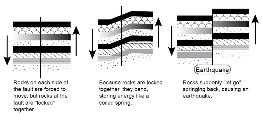
However, most earthquakes are produced by elastic rebound. We’ve already seen that rocks are moving around on the planet and that the pull-apart action has allowed Death Valley to drop down. We will see that other motions occur as well, with one group of rocks moving past another. Where rocks are warm and soft, they flow. Where cold and hard, they cannot flow.
Consider, for example, two large pieces of rock, such as southwestern California and the rest of the state. The southwestern part of the state, from Los Angeles to San Francisco, and the adjacent ocean floor are moving northwest relative to the rest of the state. The break separating the different parts is called the San Andreas Fault. (Both sides are moving westward, but the southwest side has an additional bit of northwesterly movement relative to the northeast side. Faults may go east-west, or north-south, or any other direction, may be vertical or angled, and the rocks may move vertically or horizontally or in-between across the fault.) The forces that move the rocks are huge and applied over large areas so that far from the fault the motion is smooth. But at the fault, rough patches can get stuck against each other and become locked for a while. The rocks then bend. This bending is elastic—it can spring back. Eventually, the stress on the rough spots becomes too great, the fault “lets go”, and the bent rocks “spring back”. The springing back is very rapid, in the same way as for a spring or a rubber band. Displacements of several feet (more than a meter) or more are possible in much less than a second. A building sitting on the rocks near the fault can be subjected to very large accelerations and may fall apart.
Such an earthquake will shake rocks beyond a fault. This is achieved through seismic waves—one piece of rock pushes another next to it, which pushes one next to it, and so on. Two major types of seismic waves are P or push, and S or shear. The P-wave is the ordinary sound wave. It represents a push-pull in the direction the wave is moving. A P-wave moving to the north will shake a mineral grain north-south-north-south. An S-wave moves slower than the corresponding P-wave. When an S-wave moves to the north, the mineral grains are shaken east-west-east-west or up-down-up-down (or some combination). A shear wave is similar to the wave you generate by shaking a rope. A piece of the rope moves up and down or back and forth, but the wave moves along the rope. The “wave” at football games is the same way—you stand up and sit down, but the wave moves along the bleacher bench. A P-wave may start a building shaking in one way, and then the S-wave hits the building and starts shaking it a different way, making the building more likely to break and fall down. (Earthquakes also make surface waves, which move more slowly than shear waves and go along the surface of the Earth like wind-driven waves on the ocean, rather than going through the Earth the way P- and S-waves do. The surface waves can also contribute to breaking buildings.)
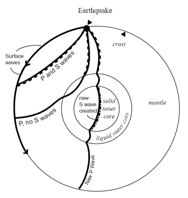
S-waves don’t travel through liquids at all. (Wiggle one piece of liquid to the side, and the moving piece slides freely past the next piece rather than wiggling it.) Recall that earlier we claimed that the outer core of the Earth is liquid. You may have asked, “How does anyone know that?” The answer is that, after a really big earthquake, P-waves can be detected all over the Earth. But S-waves are missing across the Earth from the quake, in places reachable only by passing through the core, as shown by the figure. So we know that the outer core is liquid because it transmits P-waves but not S-waves. And the outer core is nearly spherical, because no matter where an earthquake occurs on the planet, there is a zone on the other side of the Earth in which S-waves are absent. (Learning that the inner core is solid is tougher; one of the pieces of evidence is based on wave conversions. The P-wave that passes through the outer core loses some energy in making an S-wave when the P-wave hits the inner core; this S-wave passes through the solid inner core, making a new P-wave when it hits the liquid outer core again, and that P-wave travels on to the surface. The delay associated with the slower motion of the S-waves allows this to be figured out. But don’t worry about wave conversions, or the other evidence for a solid inner core, in an introductory course such as this one.)
Where Quakes Occur
Earthquakes, as noted above, occur where rocks are moving past other rocks. We have seen that this happens where rocks are being pulled apart, as in Death Valley, because the breaks often are angled rather than vertical, and the upper side slides down over the lower. We will see that there are other situations in which rocks are being pushed together, or that rocks are sliding past each other as at the San Andreas Fault, and these also can make quakes. This mostly occurs near plate boundaries. Volcanoes can cause small-to-medium-sized quakes as well, when moving melt pushes rocks aside or leaves spaces into which rocks fall.
Quakes also occur at weak spots in continents. Often, when a continent is splitting open at a spreading ridge, the tear assumes a 3-armed form, something like the Mercedes-Benz logo. (Poke your finger through a piece of paper and you’ll often get the same thing.) Two arms then grow into a spreading ridge that forms an ocean, and the third arm fails. Major rivers often form in such failed rifts. When the Americas split from Africa and Europe as the Atlantic Ocean grew, failed rifts became the river beds of the Amazon, the Niger, and the Mississippi. You open a fast-food ketchup packet by tearing at a little notch cut in the foil, because the notch weakens the foil. If the notch isn’t there, you may have to poke a fork through or end up saying bad words, because the packet is much harder to tear without the pre-existing notch. In the same way, earthquakes can occur at the tips of failed rifts, which are the “notches” in the “foil” that is the lithosphere of the Earth. Some of the largest quakes known to have occurred in the U.S. were located at the northern tip of the rift along which the Mississippi flows, near New Madrid, Missouri. Quakes also are known from an old weakness near Charleston, South Carolina.
Size of Earthquakes
There are several ways to measure earthquake size. The commonest is the Richter scale, a measure of how much the ground shakes during a quake. Richter developed a logarithmic scale—a magnitude 2 quake shakes the ground 10 times more than does a magnitude 1 quake, and a magnitude 3 quake shakes the ground 10 times more than does a magnitude 2 or 100 times more than does a magnitude 1. You may think of the number of zeros after the 1: if the ground motion of a magnitude 1 quake is 10 (you can choose the units you use, or the distance from the quake at which you measure, to get a motion of 10), then at the same distance from the quake in the same units, a magnitude 2 moves the ground 100 (two zeros), a magnitude 3 moves the ground 1000 (three zeros), a magnitude 0 moves the ground 1 (zero zeros), a magnitude -1 moves the ground 0.1, and so on.
The ground motion can be measured with special instruments called seismographs. Scientists usually look at either P-waves or surface waves to get the size of the quake. The motion must be corrected for distance from the quake; the farther away from the quake your seismograph is, the smaller the ground motion you will measure. Distance can be calculated from the difference in arrival time between the first P-wave and the first S-wave from the quake to reach the instrument, using the difference in speed between P- and S-waves, or by timing the arrival of the earthquake waves at three or more stations, and determining where the quake must have been so that the waves arrived earlier at this station than at that one.
A Richter magnitude 1 quake is just big enough to feel if you are standing on the ground very near where the quake occurs. Magnitude 3 or 4 quakes are usually strong enough to convince some people to call the police (although it is not obvious what these people want the police to do), and magnitude 5 quakes usually cause some damage. The largest known quakes, around 9, each release about 10,000 times the energy of the first atomic bombs.
Small quakes are very common and large quakes rare—one or more years may pass between one magnitude-8 quake and the next one anywhere on the planet. Approximately, each increase in magnitude of 1 causes a 10-fold decrease in frequency of occurrence. But, moving the ground 10 times more takes about 30 times more energy, so most of the energy release and the damage is by the few big quakes rather than by the many little ones.
Predicting Earthquakes
A tremendous amount of effort has gone into trying to predict earthquakes. This is because they are so destructive of life and property. Seventeen quakes are estimated to have killed more than 50,000 people each, and the worst, in Shaanxi, China in 1556, is estimated to have killed over 800,000. (In the U.S.A., the worst death toll was 503 in the San Francisco quake of 1906.) The magnitude 9.0 Tohoku earthquake in Japan in 2011 killed over 15,000 people, although the toll would have been far, far worse if the Japanese had not put so much effort into making strong buildings and otherwise planning to reduce the damages. Earthquakes usually kill by dropping pieces of broken buildings on people, but also by triggering tsunamis (big waves) or landslides, and by breaking gas lines or other things that cause fires.
The easiest way to “predict” quakes is to identify those places where quakes are likely to occur. This can be done from historic records, and from prehistoric geologic evidence. A pattern of landslides of a single age in a region, or of drowned forests related to land subsidence, may indicate the effects of an earthquake. Once people know where quakes are likely, appropriate zoning codes for buildings can be enacted. Spending a million dollars on special engineering for a building to survive quakes is wise indeed near the San Andreas Fault, and really helped Japan, but may not be necessary in State College, Pennsylvania, where big quakes are considered to be highly unlikely.
Other ideas have been advanced for predicting quakes. One is to use patterns of seismicity. If one section of a fault has had a quake every 20 years for the last century, you might expect another quake 20 years after the most recent one. Also, a fault that is slipping and moving may have lots of little quakes, whereas a locked fault that is building to a big quake may have no little quakes. So you could use such a no-quake “seismic gap” in predictions. Such a pattern—historical repeats and a seismic gap—was used recently to predict a quake near Parkfield, CA on the San Andreas Fault. The prediction failed miserably. The possible explanation is that there are many faults in that part of California, and several big quakes occurred on faults near the San Andreas shortly before the expected quake. These certainly perturbed the state of stress at Parkfield, at least delaying its quake. (The other quakes allowed rocks to move, and even caused some faults to run backwards compared to their normal behavior for a while, taking the load off and delaying the next quakes.) This illustrates the difficulty of predicting quakes. Perhaps, if the motions of all of the important blocks were monitored, one could model the whole system and do a better job of predicting where stresses are accumulating. Such work is ongoing, but results are not yet in.
Even if pattern-predictions of earthquakes can be made to work, the predictions are unlikely to be precise enough to really tell us what we want. Knowing that a quake will occur sometime in the next few years, or even the next few days, does not allow us to get people out of old buildings, off bridges, etc., during the quake. The best hope for predictions within hours or minutes is to find premonitory events. As the stresses build toward failure, rocks may begin to crackle, groundwater may move around in the cracks so that water rises in some wells and falls in others, electric signals may be given off by the cracking rocks, and animals may act strangely. The difficulty is that groundwater rises and falls in wells for many reasons, strange actions in an animal may indicate bad feed, mating season, or any number of other causes, and other premonitory events of earthquakes also have non-earthquake causes. The subtle clues to an earthquake may be recognized using 20/20 hindsight, but no one has figured out how to read them in advance. The possibility is there, though, waiting for brilliant insights and hard work by some interested researchers. (After a big quake, lots of people show up claiming that they predicted it, but none of these “predictions” has ever been verified. And, many people, including some scientists, have made predictions of particular earthquakes to come, but again, these predictions have not proved to be useful.)
Virtual Field Trips
Virtual Field Trip #1: Death Valley National Park

.jpg)
.jpg)
.jpg)
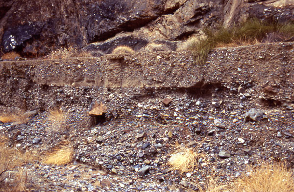
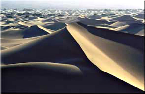
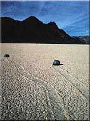
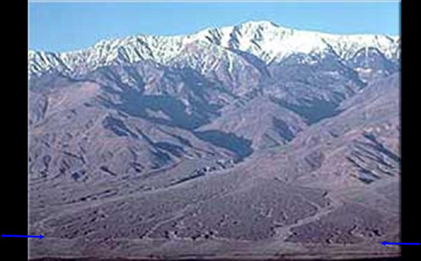
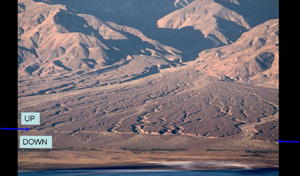
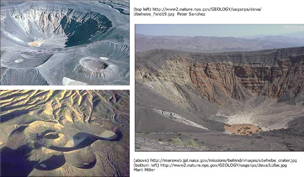
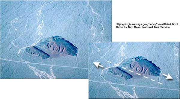
Image 1: Death Valley: Take a stroll through one of the lowest peices of land in the Western Hemisphere (282 feet below sea level), a place that, strangely enough, also happens to be adjacent to the highest point of land in the lower 48 states of the U.S., the 14, 494 ft. mountain peak of Mt. Whitney.
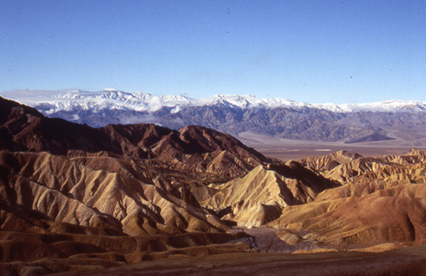
Image 2: Zabriskie Point, in midwinter. The soft sediments at Zabriskie Point were deposited in an old lake, and are being eroded into the beautiful features seen here. The snow-covered peaks in the background tower two miles above the valley floor. (Photo by Penn State graduate, now University of New Mexico professor, Peter Fawcett.)
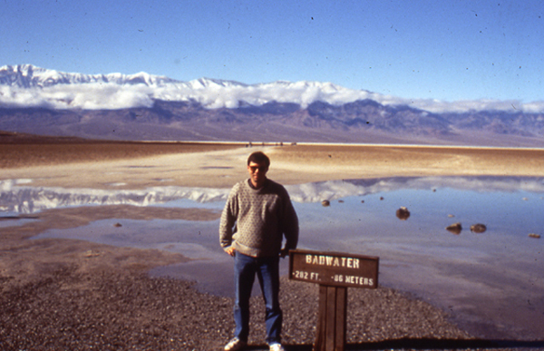
Image 3: Badwater in midwinter. Peter Fawcett, noted Penn State alumnus and University of New Mexico professor, at 282 feet below sea level. The little bit of water from a midwinter storm will evaporate quickly.
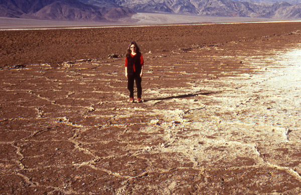
Image 4: Salt flats in midwinter, Death Valley. Water, such as seen in the previous picture, carries dissolved minerals (ask a plumber who has tried to remove a faucet in a house with hard water if you don't believe this!). When the water evaporates, the salt is left. Photo by Peter Fawcett.
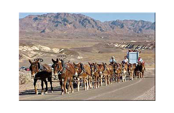
Image 5: 20-mule team. The salts deposited in Death Valley included valuable materials such as borax, containing boron dissolved from volcanic and other rocks around the valley. The salts were mined, and the borax hauled out by 20-mule teams. This is a picture from a reenactment of the mule teams, years after the mining ceased. Photo by Ed Derobertis of the National Park Service.
Image 6: Probably the most familiar of the many uses of borax is in laundry detergents. Before he was president of the United States, actor Ronald Reagan advertised a laundry detergent containing borax, as shown in this photo from the National Park Service archives.
Image 7: Another salt flat is shown here. Behind the salt flat, at the foot of the mountains, is an alluvial fan, a pile of gravel brought down into the valley from the mountains by streams that run for a short while after rainstorms. The vertical distance between the lowest point and highest point on the fan is greater than the vertical distance from Spring Creek to the top of Mt. Nittany near Penn Stateas University Park Campus--the fan is taller than most eastern mountains! The scale of things in Death Valley is immense, and very difficult to comprehend. Photo by Peter Fawcett.
Image 8: Again, putting Penn State’s Mt. Nittany, or many other eastern mountains, into this picture wouldn’t change it much - they would reach only part of the way from the salt flat at the bottom (shown by the orange arrow) up the fan (the top of the fan is shown by the yellow arrow), far shorter than the peaks in the picture. Photo by Peter Fawcett
Image 9: During the ice age, more rain fell in Death Valley because storm tracks had moved, and less water evaporated because temperatures were lower than today. A huge lake filled Death Valley then. In this rather fuzzy slide downloaded from the USGS-National Park Service web site, the horizontal lines (the ends of one are shown by the blue arrows) are old beaches from that lake. The photo of Shoreline Butte is by Marli Miller.
Image 10: Some of the gravels washed into the valley by streams are shown in this photo by Peter Fawcett.
Image 11: Deserts are not dominated by dunes in many places, but dunes do occur. The streams flowing into Death Valley carry salts, big rocks, but also sand. If the sand is piled by wind, beautiful forms may result, such as these. Photo by Paul Stone, United States Geologic Survey
Image 12: The enigmatic Devil's Racetrack. The stones rather clearly have moved across the surface of the salt flat. Strong winds during wet times are probably involved. Perhaps a thin water layer forms in a winter storm, freezes on top on a cold night, and then the wind drags the ice carrying the rocks. Photo by Marli Miller, from the Death Valley National Park web site.
Image 13: Death Valley was dropped along faults (or the mountains were raised, or both). The Hanaupah Fault (between the blue arrows) cuts the toe of an alluvial fan coming down from Telescope Peak, shown in this photo by Marli Miller from the Death Valley National Park web site.
Image 14: A closer view of The Hanaupah Fault (between the blue arrows) as seen in the previous picture, with labels showing which side of the fault was raised (“UP”) and lowered (“DOWN”). Photo by Marli Miller, from the Death Valley National Park web site.
Image 15: Hot rocks occur at shallow depth under Death Valley, and break through occasionally in volcanoes, usually coming up along faults; farther to the south, stronger volcanism has made the sea floor of the Gulf of California. In Death Valley, the eruptions are not especially strong, but they have made craters, such as those in the Ubehebe volcanic field, shown in these photos.
Image 16: Sometimes, volcanoes make small cinder cones, composed of little rocks and hardened blobs of lava thrown through the air. And, sometimes faults move rocks horizontally, as shown here (upper left without lines, and lower right with fault shown by dashed line and motion by arrows) for Split Cinder Cone in Death Valley. Most of the faulting in Death Valley is related to the dropping of the Valley and raising of the mountains, but horizontal motions such as this do occur occasionally.
Virtual Field Trip #2: West Yellowstone, Earthquake Lake

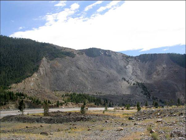
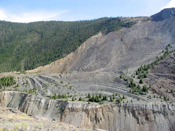
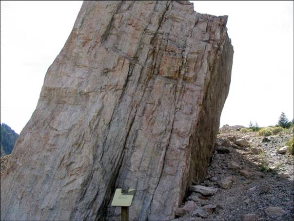
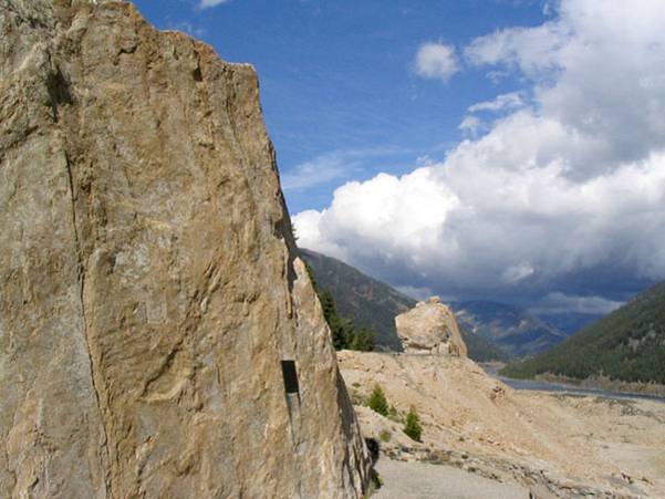
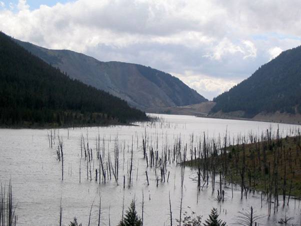
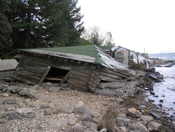
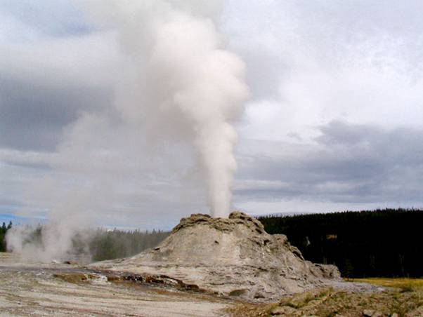
Image 1: Earthquakes! Take a quick virtual tour with Dr. Alley through the U.S. Forest Service Madison River Canyon Earthquake Area. (last picture is in Yellowstone National Park)
Image 2: On the night of August 17, 1959, at 11:37 PM, a large (magnitude 7.5) earthquake struck just northwest of Yellowstone, near Hebgen Lake in the Madison River Canyon of Montana. Land on the west side of the Cabin Creek Fault moved down about 21 feet (almost 7 m) relative to land on the east in a sudden drop that shook the surroundings, forming the Cabin Creek Scarp, shown here. (A scarp or escarpment is a steep ramp connecting places that are more nearly horizontal; think of a wheelchair ramp between sidewalks down here and up there.)
Image 3: The shaking caused a massive landslide from the south side of the Madison River Canyon. An estimated 80 to 90 million tons of rock and debris thundered into the canyon, forming a layer estimated at 400 feet (120 m) thick in the bottom of the canyon and bouncing another 400 feet up the north wall. The scar left when the rocks fell is shown here. 26 people died in this vicinity, most in a campground that was buried under the landslide debris. (Two more were killed by a falling boulder elsewhere.)
Image 4: This closer view of the scar from the landslide shows large trees next to the slide and growing in the scar, emphasizing the immense size of the slide.
Image 5: Huge boulders were carried across the valley and up the other side. The rapidly moving mass of rock blasted air and river water in front of it; some survivors reported having their clothes ripped off by the force of the blast.
Image 6: Another shot of the immense boulders carried across the valley by the rapidly moving mass of rock.
Image 7: The landslide dammed the Madison River, and the trapped water rose to form Earthquake Lake, drowning many trees that still are visible, as seen here. Quick work by the US Army Corps of Engineers stabilized and lowered the new dam. Landslide-dammed lakes often overtop their dams, cut down through the loose debris, and release a devastating flood; this was avoided by the quick government response.
Image 8: Hebgen Lake was a reservoir a little upstream of the new Earthquake Lake. On the night of the earthquake, Hebgen Lake’s dam cracked and water washed over, but the dam did not fail. The land under the lake tilted, raising one side and lowering the other. One person ran safely from her house as the lake rose and the house and land slipped into the waters. Huge waves sloshed back and forth in the lake after the quake. Houses knocked down and flooded by the tilting and waves are still visible, as seen here.
Image 9: The quake caused many changes in Yellowstone, stopping some geysers, starting others, and changing the patterns of still others. Many tourists fled in panic, small landslides and rockfalls were triggered, dishes fell off walls in houses, etc., but no one was seriously injured in the park. Earthquakes such as this probably have occurred many times over the geologic history of Yellowstone, although this was the largest experienced in Yellowstone since modern instruments were installed to provide measurements. Monument Geyser, in the Upper Geyser Basin, is shown here; this one was not affected more than most, but it's pretty.
Virtual Field Trip #3: Alaska & San Francisco
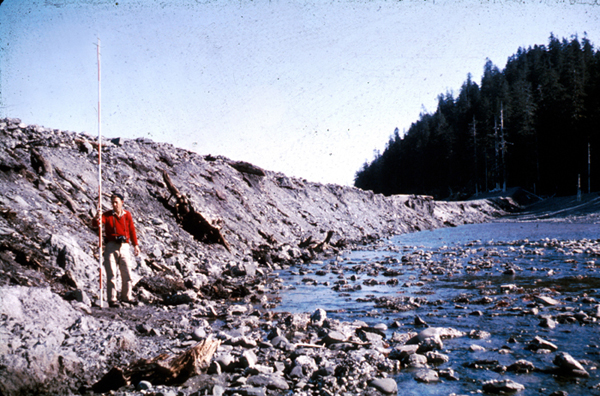
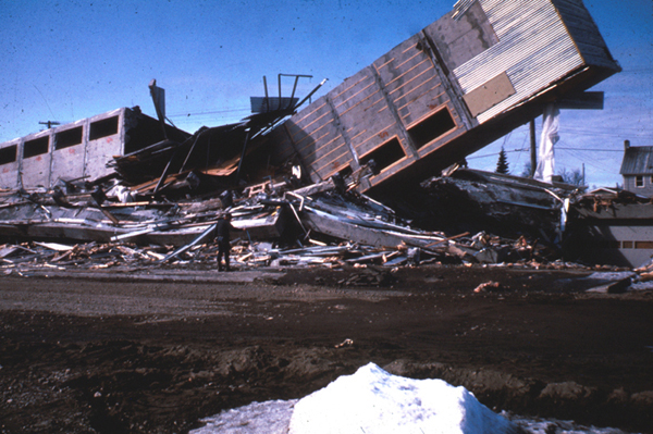
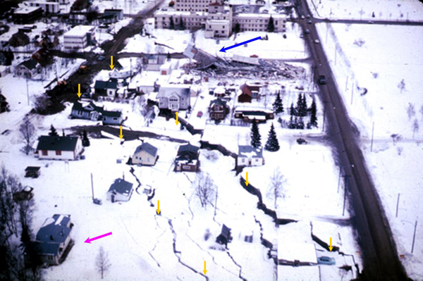
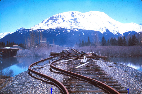
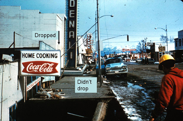
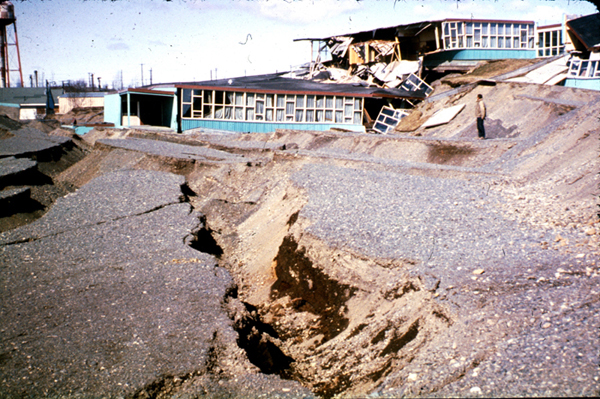
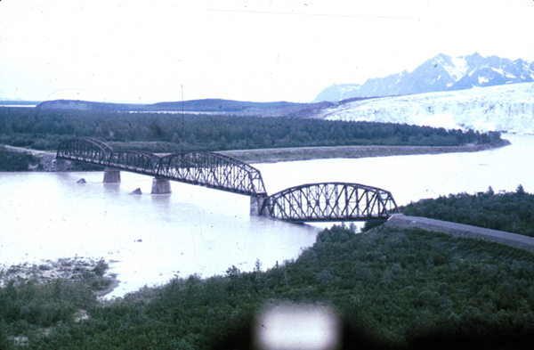
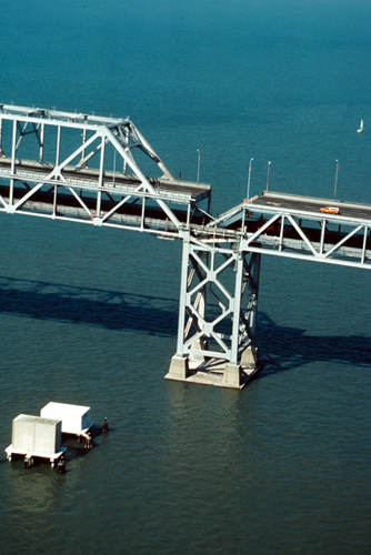
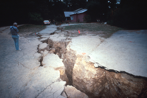
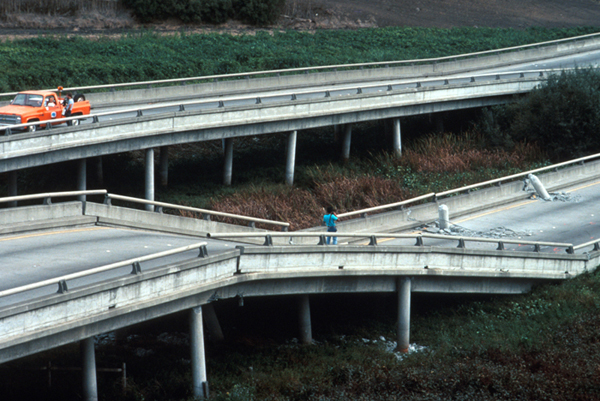
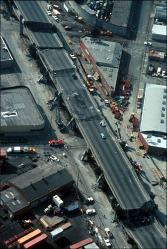
Image 1: More Earthquakes! Visit Alaska & San Francisco to get a glimpse into the effects of major earthquakes. Photos courtesy of the U.S. Geological Survey
Image 2: Alaska Earthquake, March 27, 1964. The geologist on the left stands in front of the Hanning Bay fault scarp on Montague Island. During the earthquake, the scarp formed when the rocks on the right dropped suddenly relative to the rocks on the left--the scarp is 12 feet high beside the geologist, and 14 feet high near the trees in the background.
Image 3: Alaska Earthquake, March 27, 1964. The Four Seasons Apartments in Anchorage was a six-story lift-slab reinforced concrete building, which cracked to the ground during the earthquake. The building was under construction, but structurally completed, at the time of the earthquake.
Image 4: Alaska Earthquake, March 27, 1964. The shaking caused some land to slide toward the ocean. Everything in the lower-left corner of the picture moved about 11 feet farther to the lower left in the direction shown by the magenta arrow, toward the ocean bluffs that are just out of the picture in that direction. The strip of land between the yellow arrows dropped by 7 to 10 feet, as indicated by those arrows. Notice that several houses were left hanging over the void, to be destroyed later. The collapsed apartment building from the previous slide is visible at the top of this picture (blue arrow).
Image 5: Alaska Earthquake, March 27, 1964. The shaking caused the banks on both sides of the river to landslide toward the water carrying the rails along, as shown by the blue arrows at the bottom. This in turn caused the rails to bend, and also buckled up the center of the bridge, as shown here. This is near the head of Turnagain Arm, not far from Anchorage.
Image 6: Alaska Earthquake, March 27, 1964. The Denali Theater was built on a block that dropped as the shaking of the earthquake moved land toward the sea, but Fourth Avenue was just beyond that moving block and did not drop. The marquee is now at eye-level.
Image 7: Alaska Earthquake, March 27, 1964. This was the Government Hill Elementary School in Anchorage. It was not designed as a split-level.
Image 8: Alaska Earthquake, March 27, 1964. Bridges and buildings are usually designed so that they don’t fall down. An earthquake moves the ground horizontally as well as vertically, so buildings and bridges often fail by falling sideways, as happened to the “Million Dollar” railroad bridge over the Copper River.
Image 9: Loma Prieta, California, Earthquake, October 17, 1989. The Bay Bridge between San Francisco and Oakland failed during the earthquake, with the upper deck falling onto the lower deck of the double-decker bridge, killing one person.
Image 10: Loma Prieta, California, Earthquake, October 17, 1989. The shaking of the earthquake caused landsliding and other land motion, destroying this driveway in the Santa Cruz Mountains.
Image 11: Loma Prieta, California, Earthquake, October 17, 1989. The shaking knocked this section of Highway 1 near Watsonville off its bridge supports, which poked through the road bed.
Image 12: Loma Prieta, California, Earthquake, October 17, 1989. The shaking of the earthquake caused collapse of the Cypress Viaduct of Interstate 880 in Oakland. 40 of the 67 fatalities caused directly by the earthquake happened here, primarily to drivers on the lower deck who were crushed by falling of the upper deck.
Here are some optional vTrips you might also want to explore! (No, these won't be on the quiz!)
Death Valley National Park (Provided by UCGS, 3D version requires red/cyan stereo viewing glasses)
GeoMations and GeoClips
About GeoMations
GeoMations are drawings that are captured as animations, narrated by Dr. Richard Alley and posted on YouTube for you to review at your own convenience.
The material in these drawings is almost never new—rather, it is a visual presentation of ideas and concepts you'll have already encountered in the readings and lectures. It's also important to note that these drawings are like the rest of the material presented to you in this class — that is, you should expect to be familiar with all the GeoMations in order to be successful in your weekly quizzes, just like you need to be familiar with the readings, the notes, the slide shows, and anything else included this week.
Death Valley
The great depth of Death Valley was not excavated by a steam shovel or an atomic bomb, nor were the rocks ground down by rivers, wind, or glaciers. Death Valley was dropped, as the sides of the valley were pulled apart as part of the great motions of the planet’s rocks. High drama indeed. Here is a brief description:
Sierra Nevada Mountains, a big, beautiful mountain range sitting way the heck up there. Got gimongous trees growing on top of it, and so you're going to tell that this is a slice that I am showing you through the mountain range, and then bang, down into Death Valley, way down, deep, hot, starkly, gloriously beautiful place. Place you desperately do not wish to be in the summer without your water bottle. But then there's another range, and another valley, and another range, all the way across Nevada, many more than shown here. And eventually, up in the Wasatch in Utah, end up where you'll find all these skiers standing around. That's Snowbird, so here's a skier so you can remember that this is Snowbird.
And so this is a picture of the west. If, however, you could see underground, what you would find is that there's a break along the front of the mountains. And that break continues on down. And all of these things have breaks sitting underneath them, running down underground. They're earthquake faults.
Furthermore, what you would find is that there has been motion, that the mountains have been raised and the valleys have been dropped, the mountains raised and the valleys dropped all the way across here. And for this to be happening, there has to be space made for the valleys to drop into. And so, in fact, the west is getting wider, and that creates the space into which the valleys drop and the mountains raise.
If you were able to find a particular layer of rock that you cared about, you might find it up here, and then you would find it way down below somewhere. And then you'd find it up, and then you'd find it down below, and so on across. And so it's a fascinating thing that the west is getting wider. You can measure this with GPS. It's actually there. It's shown in the geology, and there's a big story here.
In addition, one thing that one finds in the west is that there are volcanoes, as well. And those volcanoes tend to come-- that blue line-- it really should be a red line there-- the volcanoes come up, and they often leak up along the cracks, and spout up along the sides like this. And you get pretty little volcanoes growing. And that's part of the important story of how the west works, as well.
Baja
A person zipped into too-tight pants may “leak out” as the zipper is lowered. Baja California is being unzipped from the mainland of Mexico, and the leak is a volcano making new seafloor. If the unzipping continues, the sea might someday extend up toward or into Death Valley. Get a good grip on your zipper pull, and let’s go see.
So we're going to slice our way through the earth. We're gonna drive off of Baja, California, down undersea, and across. And out in the middle, we find this big bridge. And then sitting out there is Death Valley. And then we're going to come on across and back up onto the coast of Mexico.
And just to make sure it's clear, this is all under water. So here's the waves of Baja. If you're really keen about SCUBA diving, this is a good place to go. And there's birds flying over the top, and there's little boats that are floating in the water, so you can see what the thing is.
Now, if you were to measure the motion of this stuff, we're going to find that it's doing what we've seen elsewhere, which is, there's a motion going away from this ridge. If we could look very carefully, we would find that there is a volcano underneath this, and so material is leaking up into the cracks and making little volcanoes. And as it comes up in the cracks here, it hardens.
Looking at what's undersea, you find that there are lots of rocks that hardened in the cracks. And so the whole seafloor is made of these rocks that hardened in the cracks, and the oldest ones are farthest away from the center. So they get older if you go out on either side.
If you were interested in fish poop and wind-blown dust, and things of that sort, you'd find there's almost none of them on the seafloor very close to the center. And then as you go away, they become more and more common. And that's because there's been more time for them to pile up, and very close to the center of the ridge, they just have not had very much time to pile up at all.
Now, you might imagine that this is related to other things. Then you remember that way down in the earth, one finds convection cells. And so you get the convection cells coming up and then spreading aside, and a little bit of leakage is coming up into the crack that it makes, making seafloor. And all of the world's sea floors are made in this way.
Fault Types
You can push things together, pull them apart, slide them past each other - or some combination of pushing or pulling while sliding. Nature does the same, giving different types of faults, which are found in different geological settings. Here’s a quick look.
There's three major fault types that correspond to the three major plate boundary types. And we're going to look at these. They're push together, pull apart, and slide past. And so right now, we're looking at a block of rock. And this block of rock is being squeezed by great tectonic stresses that are pushing on it from the sides. And this block of rock happens to be the place that you decided to build your giant, multi-million dollar McMansion that's just sitting up there on a hill.
Underneath your beautiful McMansion, there is an interesting yellow layer of rock, which you can follow. Now, we hope that you were smart enough, when you built your McMansion, that you didn't fail to account for the earthquakes that happen in the place that you built it, because otherwise, you're going to be an unhappy camper. Because when the earthquake happens, you shove one side above the other in the push together environment, and then your house tends to fall down, and then you'd better know your insurance agent very well. And the layer of rock will be offset in the earthquake. So that is a push together plate boundary.
We also know that there are pull apart plate boundaries that are going to do a different motion pattern. There is a block of rock again. You have gotten the insurance settlement on your McMansion, and you have built a new one, which is sitting up here on the hill. But uh-oh, you didn't check with your geologist friends, or you didn't remember your GEOSC 10, and so now you have a fault underneath you.
But it's a slightly different fault in this case, in the sense that rather than being pushed together, now this one is being pulled apart. If you have a pull apart fault going on, then what you will find is that sometime later, you're in a Death Valley situation. The earthquake happens. It drops the valley relative to the mountain, and you get an offset that looks something like this.
Your yellow layer of rock is still there. It has still been offset. And again, if you haven't been careful in your construction, or you haven't worried too much about things, your house has fallen down and your insurance agent would be a good phone call.
Now, there's a third possibility. Suppose that you've now gone broke because you didn't have good insurance. You're flying over the San Andreas Fault, and as you look down at the San Andreas Fault, you see the highway that's crossing the fault, and you're very pleased to see your new gas station where you're working because you have to raise money somehow. And in the middle of your highway, there are these beautiful, really fat dashed yellow lines that you see.
Now unfortunately, if you're not careful, you may have problems yet again, because the San Andreas Fault has motion going on. And so you come back some time later and the road has been offset, and the offset of the road is not a good thing for you. It came about because of the tendency for the west side of California to move north and the east side of California to move south.
And when it did what it was doing, the cars come driving along. And if a car comes driving along this particular highway and isn't careful what the car is doing, why, the car will run over the rubble that is left of your gas station after the earthquake. And so these are the three possibilities, the push together, the pull apart, and the slide past earthquakes corresponding to those plate boundaries.
GeoClips:
Dave Janesko, a geologist, was one of the students on the CAUSE trip. Here, he and Dr. Alley explore the great Sevier Fault just west of Bryce Canyon in Utah. The pull-apart action that opened Death Valley actually affected a lot of the west and is responsible for the Sevier Fault. The red limestone of Bryce was deposited in a lake. Much later, black lava flowed over the top and cooled. Then, the faulting occurred, and the black rocks were dropped to lie next to the red ones. Where the two meet along the nearly-vertical although slightly inclined fault, the red rocks show no sign of having been heated by the lava, so they must have been put together when cool. The red and black show near-vertical scratches, formed when the rocks slid past each other to get where they are now. So, join Dave on the fault.
CAUSE 2004 - The Fault Hunters
OK, so we're standing on the Sevier Fault right now. This side over here is basalt. You can see the dark, black color. Over here, again, is the Eocene pink member of the Claron Formation, and it's the red rocks. So right now I'm going to show you exactly what was going on here, what a normal fault means.
So all right, let me figure this out. Richard, how do you think I should do this?
What I would probably do is something like this. I'd do this one's deposited in a lake, later the lava flows came out and they were deposited on top and across in various places. And then after that, the fault broke and this one has dropped down so now that it's next to it rather than being on top of it.
Sounds good.
Something like that.
All right. Maybe I should just use that.
This rock right here is 40 million years old. This is from the Eocene Claron Formation, and it's a lake deposit. This is what we saw earlier. And this right here is a piece of the basalt, which is Miocene, which is 10 million years ago.
And what this would look like in cross-section, something like this. The Claron, some more rocks, and then the basalt was deposited on top of it. Now when the fault occurred, these rocks would drop down along it like that. And now they're sitting right next to the Claron Formation, which they really didn't have any association before.
Right now we're on this basalt here. I'm on the south side, and if you can look in the distance there, you can see how this line of this fault moves right along into the distance. So again, the red rocks on that side, and the basalt on that side.
Richard, you, why does the basalt have more trees than the red side?
The soil probably?
It erodes faster on the right.
It will erode faster, and it's probably more minerals and nutrients in it.
In basalt?
Yeah.
Yep, doing great. Just be careful out there.
Then just take a pan from this.
Want to see more?
Here are some optional videos and animations you might also want to explore! (No, these won't be on the quiz!)
The original "geyser" in Iceland
Yellowstone has roughly half of the world's geysers, but there are geysers in New Zealand, Iceland, and elsewhere. The original "geyser" is Geysir, in Iceland. Here is a short film clip of Geysir erupting, just for fun. Filmed by Vicki Miller.
Plate Tectonic Movement Visualizations
Watch the NSF-sponsored video on Plate Boundaries
San Francisco Earthquake Aftermath 1906
(Amazing film footage that is now over 100 years old!! Click on one of the "View Movie" options on the left side of the new page to watch the 1:39 minute clip.)
Video Lecture
Please watch the 50-minute Unit 2 lecture featuring Dr. Richard Alley.
Hello, and welcome to another day of Geoscience 10. This one is maybe a little bit like an old-style fraternity initiation. We make you run through something really hard to get started.
And so we're going to go cranking through a lot of material in a fairly big hurry here. You will find this material is supplied to you in the textbook, in much slower and greater detail. You also will find there's a lot of v-trips, virtual field trip slide shows that are online. So you can see the pictures that I'll show you here, in much greater detail and at your leisure.
There's actually only a few big ideas that we're going to go through here. But they may be different for you. You may have seen them in some earlier class. But if you haven't, I hope you'll find this interesting.
We have started into the big picture of how do you make mountains. After we make mountains, then later we will tear down mountains. And then we will see about how people live on earth, how animals live on earth, what the history of the planet is. So that's sort of the broad outline of the course, building mountains, tearing mountains down, living on the planet.
And we're going to start with making mountains. We'll do some earthquakes, and we will look a little bit at what we call plate tectonics, which is the vast underlying processes that make the mountains. We're going to do this by starting at one of the more interesting places that you could go for a national park, which is to go to Death Valley. OK?
So we'll look at Death Valley. We will look at how it is spreading apart. How that spreading is being driven by the heat within the planet. And then we will briefly pop by Yellowstone, just long enough to see that it's shaking, and what we can learn about that, about the interior of the earth from earthquakes and so on.
You will be given, for each of the parks we visit, one or more v-trips, virtual field trips. We would love to take you and zip out to the parks and have a good time. We haven't quite figured out how to do that. And so we've done the next best thing. We've gone ourselves. Some of our friends have gone. We've collected pictures and put them together, so that you can see virtual field trips. And so you will find these online.
This is Death Valley. Death Valley is tremendous. You're looking at the lowest spot on the continent, right here. And in the background you're looking at a spot that is more than two miles higher. It is just phenomenal.
These pictures were actually taken by Peter Fawcett, shown here. Peter worked with me a number of years ago and is now a professor in New Mexico. And he was out there in the dead of winter. You can see the snow way up high on the peaks above Peter's head. You can see a little bit of water behind Peter.
It does snow, it does rain in Death Valley. The water does come down in the valley. And in the winter it may puddle for a little while. And then, poof, it evaporates. And it's gone very, very quickly. And when it evaporates it leaves salts behind. And so you can see the white salt behind Peter, there at the picture.
That was economically important in Death Valley. Some interesting things dissolve out of the rocks. They come down in the valley with the water. They're left when the water evaporates.
And you could go and mine these. And so early people actually did mine in here. The 20-mule teams hauled boron salts, borax out. And this was used in soaps and paints and glass making and all sorts of other things. And it contributed to economic development in this area.
And also, one of our former presidents, President Reagan, earlier in his career, before he was president, sold soap. And he sold Boratine, which had borax, which came with the 20-mule teams. And so he was something of a celebrity, in part, based on Death Valley soaps.
A point in this course, you will get the joy and privilege of taking quizzes occasionally. In each time we visit a park, we're going to give you introductory material such as this. And we do this, because we find it interesting. We think you will. We hope that some day you'll be off on a road trip, and you'll get to go see these things. And this will help in your visit.
We would never, on a quiz, ask you which president sold soap. Nor would we ever ask you, which soap did the president sell? This is strictly for your edification and enjoyment.
Once we get to the point of saying, OK, geology is tearing Death Valley apart, that could show up on a quiz. But this early stuff, what's pretty, what's neat, what's exciting that you want to go see this park, this is for you. So please do not attempt to memorize the soap that President Reagan sold before he was president. That doesn't— that's just for you.
But Death Valley is something. This picture, the scale here, if you ever been to Penn State's University Park campus— and we're very impressed around here with our mountain, Mount Nittany. If you put Mount Nittany in this picture, it would tower over that little white line on the far side of the picture, almost a third of the way up that first slope.
There's nothing in the Appalachians that you could put in this picture that would look even vaguely large. You'd drop the whole Appalachians in this picture, and they would not go halfway up. This is immense. It's just truly an awesome place to get to.
You find the right place in Death Valley, such as the one you see right here, and there's beaches. During the ice age, when it was colder, the rains that came in didn't evaporate as fast. There was a big lake in Death Valley, which has now evaporated.
You go and look various places in Death Valley, and you'll find that the floor of it is salt and it's gravels and things. The streams are tearing down the mountains. They're dumping stuff down in the valley to fill it up.
And yet the valley is there. The valley is there, even though they're trying to fill it up. There's a little bit of sand, a little bit of sand dunes. Not too much. Usually the desert is not sandy. But there are such beautiful things as this.
There are really amazing things. You can look at this picture. You see those big rocks out on the salt flat. And those rocks have moved. And people have come and surveyed them, and they do move.
And we're still not absolutely positive how. The best picture is when it rains, you get a little water here. And then in a really cold day in the winter, it might freeze. And then these rocks are locked in the ice.
And the wind blows, and it pushes along on the ice, and it actually sort of skates these things along. But no one's sure. Racetrack Playa, the rocks move somehow. Neat place, neat place to visit.
The valley is actually growing. It's widening and it's deepening. And if you look at this picture, you can see the great mountain range towering more than two miles above the valley.
And you'll see right along the bottom, it's just a straight line. Well, that straight line is actually an earthquake fault. And here's another view of it. The near side has dropped. The far side has been raised.
These things happen. They are ongoing. It is part of our world today. And that's really what's very interesting and why we're visiting Death Valley at this point, is why are things moving? What's going on on the planet?
When this motion occurs, occasionally volcanoes come leaking up along the cracks. And so you can see volcanic craters if you go and visit Death Valley. You can see some places. This is an old, little volcanic feature, which has been torn apart by motions.
This is a slightly different motion. Most of Death Valleys' motion is sort of an up and down thing. This one's a little bit of side to side as well. And the diagram will show you what's going on. Things are moving away there.
So there's some pictures of Death Valley, if you get the chance to go. If you want to impress your friends, go in midsummer. If you want to have fun, don't. It's really stinking hot. But it's a wonderful park, big park sitting on the California, Nevada border.
Now, what's going on? Death Valley is getting bigger. And it's doing so from heat down within the planet. And so that's what we have to look at a little bit now. And then we'll go see what that does at Yellowstone.
So let's do the Death Valley. OK, Eastern California, Nevada border, the lowest, the hottest, the driest spot in the country. The water does come down. It does evaporate. It does leave salts behind. This drove various economic activity. It's largely turned off now.
And now, let's see what we do. This is a cross-section of Death Valley. If you could go in and you could take a giant saw and hack your way down and then look at it sort of as a cliff, you have spaces up above in this picture. And the earth is down below, and it's shown to you as blue. And we're going to look at it. The little line across the top is just for your reference in there.
And so what's going on, Death Valley measured? If you go in and you put in GPS receivers across Death Valley and on across Nevada and over to Utah, and then you survey what's happening, what you will find is it's very slowly, about as rapidly as your fingernails grow, the west is getting wider. One side and the other side of the valley are very slowly pulling apart.
As they do so, the valley drops down. And it drops down on what we call pull-apart faults. Because you pull it apart, and then the fault allows the drop. The fault is a break where there's motion. OK.
So the block in between is going to drop down as we pull apart. And it is measured. This is not storytelling anymore. The early geologists look at this, and they said, this has to be happening. We understand that, but we can't measure it.
It's pretty hard to measure a state spreading at the rate your fingernails grow. But we can do that now. This is directly measurable by GPS. It does work.
And so this is the picture. You can actually put out your GPS and measure that the mountains on the east of the valley and the mountains on the west of the valley are moving apart. It's actively going on. This is real. It's happening today. And as they do, they allow earthquakes. And the earthquakes drop the valley down.
Erosion takes stuff off the top. It fills it in the bottom. But then the bottom drops, and the sides are raised as the whole thing is pulled apart. And so Death Valley is getting bigger. The west is getting bigger. And the fault, the break in the rock along which there's motion, there's one on each side of the valley. And basically every valley in Nevada and Utah has this same structure going on.
If you were to find a rock layer, an old friend that you happen to know— the pretty purple rock, the pretty red rock, whatever it is— you can see the pretty red rocks scribbled in on either side. If you wanted to find that in the valley, and you drilled in your oil well— you're not allowed to drill there now, but if you were, you'd drill down— you would find that same rock layer. It's down there. And you would find it down there.
Now, this is one of the things that geologists were quite confident that this motion was going on, before they had a GPS satellite to help them measure it, because of things such as this. You say, OK, what happened to the layer in the middle? There it is. It's way down below. The valley, the west is getting wider. The bottom is dropping down.
Now, here's a map version. If you want to get in your satellite and look from above, down onto these things, Death Valley you'll see labeled way up at the top of the map there, above Las Vegas. That's sort of along the California, Nevada border. And Death Valley and through Las Vegas and on down passed Scottsdale and headed to the south, all of that region is getting wider.
You'll also see looking farther down, past San Diego and Tijuana down there, that we get down to water. We get down to very pretty beaches, plus fun places that you could go diving. And what you find is that this pull-apart action of Death Valley is running all the way down to the ocean, down to the Gulf of California, down past Baja there. This whole area is being pulled apart. Baja, that piece out on the left, and Mexico as a whole are pulling apart. The same spreading that tends to open Death Valley is opening this whole area.
And so we've drawn in here, you can see a circle up by Death Valley and then a green line that runs down to the Gulf of California. And the Gulf of California actually is getting wider. It's unzipping. It's open.
Given enough time, it possibly will open all the way up to Death Valley. It is conceivable that you could, over time, actually have the ocean extend on up into the central part of the West there. We're not sure if it will get there or not, but that's what's going on. Is that whole thing is measured to be unzipping, with Baja moving out towards the Pacific, Mexico moving over towards the Atlantic, the space in between, the ocean basin getting larger.
Now, this is part of a much bigger phenomenon. As you might possibly imagine, if it's going— we started in a cool place, but you start moving things around on the continent. And if I move here, it's going to bump my neighbor and bump the other neighbor, you sort of get the idea that this must extend much farther along. And so what you find is this sort of spreading behavior. This pulling apart behavior happens not only at Death Valley, not only where Baja is moving away from the mainland of Mexico, across the Gulf of California, but it actually happens through the world's oceans.
The places that they pull apart from, it turns out, tend to be raised a little bit. We know that there's these big mountains next to the valley at Death Valley. And so there's high stuff associated with that.
If you go down under the Gulf of California, the center where it's pulling apart is a little bit higher than the rest of the sea floor. It's sort of arched up a little bit. And so we talk about spreading from ridges. And so that's spreading ridges. And so we find a lot of places in the oceans have these places that it's being pulled apart from, and they're a little bit high. OK?
If you played baseball, or if you play tennis— tennis would work too— but you'll find that the ball has a seam on it. And that seam sort of wraps around it. And we often say that you can follow these spreading ridges of the earth, and they wrap around the planet like the seam of a baseball. And they're raised a little bit like the seam of a baseball.
And so here is a map. And the black lines— you'll see one black line disappearing up there, pointing towards Death Valley. And then you'll see the black lines wrapped around the rest of the planet, primarily running through the oceans. If you look very carefully, way over on the far right of the picture, you can see where one black line sort of points down into Africa, towards the great African rifts.
And so there are other places that these black lines, these spreading ridges are trying to tear a continent apart, the same as is happening up in Death Valley. But for the most part, they're out in the oceans, wrapping around, and again, sort of like the seam of the baseball. If you're not a Mets fan, well, just imagine that that's whatever team you like to cheer for.
You will see that these black lines look a little bit like the edges of jigsaw puzzle pieces. And so you can sort of see between the black lines what you might think of as being jigsaw puzzle pieces. These are plates. And you'll see they're labeled in there, the Antarctic plate, the Pacific plate, the Cocos plate, and so on. These plates are going to be very important in our story of how the world works here, as we try to put this together.
You also see the Ring of Fire all the way around the Pacific. At the edge of the plates there's volcanoes. That's sort of fiery. And so that gives us a Ring of Fire. That is something we will revisit a little bit later. OK?
Where we started again was in Death Valley, where you can see one of these spreading ridges disappearing and trying to unzip the continent. And then you can follow that out and then on around. And these are some of the plate boundaries.
We will see, in a little bit, that while plates, these big chunks, the jigsaw puzzle pieces often have a spreading ridge at the edge. Sometimes they will have something else at the edge. And so some of the plate boundaries are shown by the red lines in here, but there are other sorts of plate boundaries that we will revisit.
And there's your baseball. And again, I can't say I grew up a Mets fan. I'm from Ohio, and so it's Cincinnati or Cleveland. But that's life.
All right, now, if you go to Death Valley, you find there's volcanoes. If you go to the center of the Gulf of California, you'll find it's hot along that spreading ridge. And in fact, there's a volcano there. There's melted rock, leaks up along that crack.
And as Baja moves away from Mexico, melted rock will sneak up along that crack and freeze. And then they move away. And more melted rock sneaks up and freezes, and it moves away. And more melted rock--
And so that should tell you one thing. It's hot down below, because there's heat coming up from there to drive the volcanoes. Certainly, if you see a volcano at Death Valley, there has to be a heat source. And so we're going to talk a little bit about heat. Because it turns out that all of this action on top is being driven by heat from below. So let's take a quick look at what is heat and how it moves around.
I'm sure, for some of you, this is really old hat. Some of you may have not encountered this before, and I hope you get something interesting out of it. The normal way we look at it, if you were able to look inside of me very, very careful, you could see all the little pieces of which I'm made are vibrating. There is heat in me. There's vibration going on in the atoms that make me up.
Atoms, as you know, smallest units of matter that are sort of recognizable as something. If you started to— please don't do this— if you started to break me up into pieces, using chemistry, using fire, using other tools that you have available to you, you could make smaller and smaller and smaller pieces down to some limit. Below that, if you wanted to break it up more, you're going to need an atom smasher or something like that.
And so the things that you can get to with a fire or your stomach or something like that are atoms. And they have, we talk about different types. I'm made mostly of carbon and oxygen and hydrogen and a little nitrogen and a tiny bit of iron and other things.
And each one of those carbons, you could pull it out, and you could weigh it. And say, oh that's carbon. And that's because of how many pieces are in it, the little protons and neutrons. And so there's a little blurb in your textbook. If chemistry is completely foreign to you, it might be worthwhile to go back and read through in the textbook. If this is old hat, great. Don't worry about it.
Now, we will come back to some of that terminology. It is true that a carbon inside of me, one of them may be a little heavier than its neighbor. And so if you've never run into an isotope in your life, you might have a quick look at that. This is going to show up for us in just a little bit.
But again, if you've never had chemistry or you completely forgot your chemistry— Oh my goodness, don't tell me about chemistry— there's about a half a page or three-quarters of a page in the text. It will get you completely up to speed. So you might have a look at that.
Now, suppose we started making it cold. The vibration slows down. It slows down. At absolute zero the vibration stops, or very nearly. There's a little quantum stuff, but don't worry about that. OK. So as you warm from absolute zero, the stuff in me vibrates and that's heat. And that's there. And it's very good, because if it wasn't going on I would freeze and that would be the end of us.
OK. So now, suppose we have some heat. There's someplace that the molecules in me are vibrating like crazy. Does the heat always stay in me, or does it go somewhere else? And the answer is, it goes somewhere else. There are other ways to get things going.
And so if something cold were next to me, if you put an ice cube on my head, it will melt. The atoms in it will start vibrating faster. The atoms in me will vibrate slower. And so I will transfer heat to it.
And so there are ways that heat is moved around in things. How does it work? One way that heat gets moved around is by what we call radiation. The lights are shining on me. I'm picking up just a little warmth from the lights that are shining on me.
It gets here by radiation through space. Radiation works great. If you wanted to get a suntan, you go out and lie in the sun, and you soak up the sun. And then you get skin cancer. And so that's maybe not a good idea.
But our cats are very clearly solar powered. Now the radiation brings energy all the way from the sun, all the way down to the cat. And the cat just sits there and soaks it up. And then the cat goes and runs around like crazy at 2:00 in the morning. And so radiation moves heat around very well through space. And as noted, don't soak too much of it up, or when you're old and feeble, you won't be happy about that.
How else do you move heat around? Conduction. If you turn on the stove burner, and you let it get hot, then you hold your hand out to one side, you feel a little bit of heat coming off the side. That's radiation actually. If you take your finger and you touch the burner, you will notice very quickly that you feel a whole lot of heat. You're feeling that heat by conduction.
The atoms in the stove burner are vibrating really fast. And when you put the atoms in your finger against the atoms in the stove burner, the collisions between the two make the atoms in your finger vibrate really, really, really fast. And then they jump out of the places where they're supposed to be, and they sizzle and combine with oxygen and disappear in the atmosphere, and your finger burns up. So don't do that either.
That is really all it is though, conduction moving heat around by collisions between a fast one running into a slow one. And then they sort of share their speed. That works really well over short distances. You touch your finger to that stove burner, and immediately you'll notice it.
It doesn't work very well over space. If I vibrate really fast, I can't make a molecule on the moon vibrate faster. It doesn't even work really well over miles and miles. If I vibrate really fast, if I had a neighbor that I could shake, and the neighbor would shake the neighbor, by the time you try to go a few miles away, it's really hard to get your neighbor to shake the neighbor to shake the neighbor to go few miles away. And so conduction works really well over short distances, not over long distances.
Convection is where we're headed. This is sort of the third big way of moving heat around. And essentially this is just taking something hot and moving it.
If you cook dinner, and the dinner's on the stove, and it's hot, and you want hot food on the table, you could go bring the hot food over. You could wait for radiation to bring the heat. You could wait for conduction to bring the heat. But I think you're going to go get the food and bring it over. OK, that's advection. But convection is just sort of that. It's the natural way for hot things to move to somewhere else, taking the heat with them.
You've probably seen convection work if you've ever cooked spaghetti on the stove. You make it hot at the bottom. It expands. It's lower in density, then it rises. It gets to the top and it cools, and then it's going to sink again. But it can't sink where it's rising, so it gets out of the way and goes around in a loop.
Wherever you have soft solids, really soft, or liquids or gases, and you heat them and they expand, you end up with convection cells running after a bit. And it works in spaghetti. It works in spaghetti sauce, even though that's a little thicker. As you can imagine, if we're talking about it here, it's going to work in the planet as well.
So convection, heated material moves to a new place, carrying the heat with it. Primarily because hot things are less dense. The vibration, as you heat it up, it shakes around more. It shoves its neighbors away.
Now you've got the same amount of stuff taking up more space. And so you get a little lower mass in a place, it's less dense. It tends to rise. In case you forget what density was, it's mass divided by volume.
So what happens if you have a low density thing down, it tends to rise. If you have a high density thing up, it tends to sink, and they get organized. And that's not a terribly tough thing.
You've probably seen it in the atmosphere. What happens and what's very interesting is that over the times of geology, slow times, even rocks will do this if they're very warm. And so you go down in the earth, and it gets hotter and hotter. It's mostly solid, except in a couple of places. But most of what's down there is solid, but it's soft. And you know if a blacksmith takes a horseshoe and heats it almost up to the melting point, it can be deformed. It can be worked.
Well, if you get a huge mass of stuff and you heat it up, almost to melting, it gets soft. If you heat it at the bottom, it can convect, even though it's essentially solid. And that's a cool thing.
But if I had a chocolate bar in my pocket, I'd eat it right now and I'd be happier. But if I had a chocolate bar in my pocket, it would be fairly soft. As you warm it almost to melting it gets soft. And I could deform it. I could make it do things.
And so the same is true in the Earth. It's warmed almost to the melting point. It's soft. And because it's soft, it can do things.
So that's a convection cell, here's a picture. OK? Now we're going to very briefly sort of divide the world up for you. What you see here is a diagram planet. There's a much nicer diagram in your text that you might want to look at.
The planet is layered, as described in the text. The center is sort of an iron ball. It's got an outer core, which is liquid, and an inner core that's solid, that's basically iron. Around that there's this vast shell that's got some iron, but it's got some silicon and oxygen and a few other things. And that is soft. It's not melted, but it's almost melted. And so that's soft.
And then on top there's sort of a layer that's too cold to flow very well. It prefers to break rather than flowing. And we call that the lithosphere. And at the very top of it, especially the crust, has a little bit more silicon and oxygen and a little less iron than the rest. And it's got a little water in it, little [? us, ?] and some other things. So it's fine.
But anyway, here's the picture, if you can see it. And so you've got stirring going on down below. You'll see the surface of the earth labelled there. You'll see that this is only part of the earth. Yes, the whole planet is spherical. And you'll see the center marked down below there. Just so you know what we're looking at and what's going on.
The spreading ridge is right in the middle, on top there, where it says ridge. You'll notice that the convection cell comes up and it spreads. And as it does that, a little bit of melt will leak up and freeze and then get pulled away and leak up and freeze.
And so you'll get the volcanoes in Death Valley. And you will get the spreading and making of new seafloor at those places that allow the motion of Baja away from the mainland of Mexico and so on. The process here, we've got this cold stuff on top, the jigsaw puzzle pieces, we call those plates. And the moving around of these on the convection cells we call plate tectonics. It's a big, fancy word. It's a fun word. And it's written out there for you, in case you can't spell from my speaking.
So again, pull apart. We started in Death Valley. It's pulling apart. A little bit of melt leaks up. And you go south from Death Valley into the Gulf of California. Baja is moving away from Mexico. There's pull-apart going on. A little bit of melt leaks up. Things are pulling apart, and they're doing so riding on the back of giant convection cells. The stuff on top is just rafting around on what's underneath, with the ridges at Death Valley being where we started.
Heated rock rises, less dense, cools at the surface of the earth. Then you sink back, and this gives you the completion of the loop. And this gives us action. This gives us motion. This gives us drama.
You pull apart here, it's going to run into something somewhere else. We're going to have rifts and collisions and earthquakes and volcanoes and fun. And so you get ultimately the heat of the earth making this go on. Rising rocks push aside the cool rocks at the surface. The cool rocks travel sideways. And there will be interaction when cool rocks run into other cool rocks, which we have to look at.
Where does the heat come from? A little bit of it may be left over from when the planet formed. There's some other things going on. Mostly it's radioactivity.
If you get a rock, and you put it in a Geiger counter, you'll get occasional action. There's always a little bit of radioactive stuff. Now, not huge amounts. You usually don't get wiped out by the radioactivity in the rocks next to you.
But it's a big planet. There's a lot of radioactivity. There's a lot of rock. That makes heat.
And that heat is ultimately the big source of what drives the planet. There is a little left from the formation of the planet, a little bit from separation of the planet and freezing of things. But mostly it's radioactivity that does it.
As a wonderful story, if you're into history— don't get too bogged down on this— but if you're into history, the physicist Lord Kelvin says, OK, I'm a physicist. I'm smart. I know all this stuff. The earth started melting, and it's cooling off. And I measure how much heat is coming out of it. That tells me how old the earth is, 24 million years.
And the geologists said, oh, no, no, no, no. It's longer than that. It's lots longer than that. It's more than 100. It's— you got to go way back.
And he said, no, no, no, I'm a physicist. I have it right.
Well, he didn't know about radioactivity. He got it completely wrong, because his assumptions were entirely wrong. Darwin as well as the geologists are saying, come on, come on, we need a longer clock than this.
And actually it took the discovery of radioactivity. Marie Curie, who is shown here, and others find the energy source and say, no, there's heat down there. This will work. Your physics was right. Your assumptions were wrong. Something worth— and so geologists, we like this. So those who study the earth like this.
OK, so brief summary. Heat inside the air from radioactive decay, it drives convection cells. The cells move plates. The jigsaw pieces on top, where it's cold, they go rafting around on the surface of the planet. Where they pull apart, you get faults, you get spreading, you may get a little volcanoes leaking up. Death Valley is one. You get ocean spreading centers beyond that.
You're welcome to pause right now and take a deep breath. [BREATHING] If not, we'll go screaming right along. We're going to briefly visit another park.
And we will look at one of the implications of this. You might say, why should I care? Who cares what's going on here?
One of the reasons this matters is occasionally things that are moving get stuck, and then they move again. And when they move, they go fast. And if you're standing on top, your feet get knocked out from under you. And if you're a building, you fall down. And that's not good.
So we're going to go to Yellowstone. And we're going to look at— Yellowstone has everything. It has geysers, and it has bears, and it has beautiful trees and lakes, and it has earthquakes and volcanoes and river erosion.
Yellowstone has everything, the first national park. The first serious European Western exploration. People are there, and they've had earthquakes. The ground shook. That's cool. Sort of everything is here. It must be going on.
Yellowstone itself is a huge volcanic pit, a volcanic caldera left from giant eruptions. And there will be another one someday, with fairly high confidence. It's due, plus or minus 100,000 years, the next one is due. You can count 1.8, 1.2, and now 0.6, but we're due. Not to worry.
Those were big eruptions, really seriously big eruptions. But we're going to visit there and talk about earthquakes. You go to Yellowstone, and if you read into the history, back here a little bit, there was actually a beauty pageant going on at the Old Faithful Inn. I don't think they do this anymore.
And in the middle of the pageant, in the late 1950s, there was an earthquake. And there's this wonderful text you can read about it, in our textbook, about all these people watching the queen walking down the aisle. And the ground starts shaking. And they all screamed and ran out.
What had happened is just west of the park there was a big earthquake. And the picture you're looking at in front of you, the side that I'm standing on taking the picture, the side that the bottom of the tree is on, dropped about 20 feet relative to the other side. And in the middle of the night, it just went PFFT! And it does this huge motion.
Now you can imagine what happens. There's a hill there. And this is a serious hill. This is a couple-thousand foot high hill. And it drops, and it stops.
Well, if I had something balanced precariously on me, and I dropped, it falls down. What happened is the whole hillside fell down, and it killed a bunch of people. It was not very nice.
But there's these dramatic stories. When the hillside fell down, it's just slid across the river, and it pushed the air out of the way in front of it. And there's this story of this guy that had his clothes blown off of him in the middle of the night. He's sitting there in his tent and pfft— the things come. So it was truly an amazing thing.
You can see the pictures here. Those are big pine trees along the edge of that failure. So this entire hillside just fell off. It dammed the river. It bounced up the other side. This rock is towering over me. And this, the rock came down into the valley and several hundred feet up the other side, in the landslide that was caused by this earthquake.
Once it dams the river, it makes a lake. The Army Corps engineer says, boy, we got trouble. Because what happens, the water's going to fill up. It's going to go over the lake, go over the dam.
The dam is loose rocks. It will cut through the dam. There'll be a giant failure. It'll kill people. That happened 100 years ago, just outside the Grand Tetons. And so fortunately, the Army Corps engineers got in there real fast, and they fixed this sucker and things worked. You can still see the damage that was done by this earthquake.
There's great stories of this lady in this house. I think it was this house. The land sort of tilted. And the lake is filling up. And there was another lake just above it that had already been there.
And her house is getting flooded. And the waves are coming at her. And it's the middle of night, and she's running away. She made it. That's all right.
The earthquake shook up Yellowstone. It changed the timing of the geysers. It did all sorts of things.
And so there are earthquakes. And we know they matter. They matter in natural places. They kill people. They cause troubles.
This is a different earthquake. 1964, Alaska had a big one. And you can see one of the things that happened there.
We usually build buildings to stand up against gravity. We make them so they don't fall down. In an earthquake, they shouldn't fall sideways.
And we usually don't build things to be strong against falling sideways. Well, you notice what happened? Things moved, and that bridge truss there just fell sideways— pfft— it fell off. It's an interesting mess.
Here's another one. This one is from the World Series earthquake in California, '87, I believe it was. An again, sort of we build things not to fall down. But it shook, and it sort of slid off, and then it— So this isn't good. You really wouldn't want to drive your car over the middle span of that bridge right now.
And when you shake the ground and things move, you get cracks and that's not good. And it's not good for houses. And this one, the road is a little perched on these little— you put a real strong thing, and it sits on a post. And then you put a road on top of it, and then it shakes and whoop, the post just poked through the road. Whoop, I didn't design it that way, did I?
So earthquakes are a very bad thing when they happen. And this is also the World Series earthquake. You can see the road is not going to be useful for a little while there.
So what's going on with earthquakes? The land moves. We've seen that it pulls apart. If it's pulling apart somewhere, somewhere else it must be running together. And occasionally there's sliding passes that go on.
And so this is a diagram of the West. This is a diagram of what you might see going on for the World Series earthquake, for the San Francisco earthquake, for the San Andreas fault. What you have out there, in fact, is that there's sort of the far-western piece of California is headed for Alaska. And so it's sort of sliding along. And the join between that far western part and the rest of the country is the San Andreas fault.
So let's see if we can walk through this. We're going to see what happens when a fault get stuck and then it breaks. And what happens is it gets stuck for a while, and things sort of bend. And then eventually, they let go. And when they let go, things happen. And so let's see what we can do here with this.
OK, so we have plates. They're moving. The North American plate is probably what you're sitting on. If you're in Pennsylvania, for example, you're on the North American plate.
But the very far western part of California is out on the Pacific plate. There's a lot of motions. Everything is sort of going that way, and then there's a little of this.
But if we just focus on how they're moving compared to each other, the Pacific plate is headed for Alaska and the North American plate is not. And so there's a little of this slide pass going on. The break between them, the San Andreas fault. And so you can just take that blue line as the San Andreas and the Pacific plate moving relative to the North American plate.
Now let's start. You have a fence or a road or a building or something. You build it across the San Andreas fault, and then things are moving. OK?
So what's going to happen is the different sides are trying to move, but that fault is not letting go. You're trying to go. Maybe they're moving a little bit, but they're not going real far.
And so you actually may start things bending. Far away from the fault it's moved. Right at the fault it's stuck. The rocks, they sort of get locked around each other, and they're getting bent.
Well, eventually what's going to happen is that bend that we have circled there, something's going to break. You can't bend rocks forever. And when it breaks, [POP SOUND], OK? There you go.
And so you go, rrr, stop. And that snap is the earthquake. It's been caught on pumps or rumps or jumps in the rock. And then it breaks and it lets loose.
What happens then? If something snaps, these are big chunks of rock. I mean, sort of everything from San Francisco to LA just moved north by 20 feet. Now, if that happens, it sort of elbows its neighbor a little bit. And so other sorts of things are going to be going on with that snap. And it could get very interesting. And it will release energy.
And so when it goes 20 feet north, it shoves what's just north of that, and that shoves what's just north of that. And the truth is, on a big earthquake, the whole planet will get shaken a little bit. It's not just shaking yourself. It's shaking lots of other places.
Where are earthquakes? Well, the red dots here are earthquakes. This happens to be 1978 to 1987, fairly large quakes. And what you'll find is that these quakes actually outline the plates, the big tectonic plates. The jigsaw puzzle pieces moving around on the planet are pretty well outlined by these red dots, as you can see by comparing to this one.
And so if you sort of remember what this looks like and remember what this one looks like, you will be able to see, and you can compare them on your own time. You'll be able to see that the plates are primarily outlined by the earthquakes. The action is mostly at the edge. There's a few places in the middle that get more interesting, but not too many.
We have been looking at a couple things out there, the pull apart at Death Valley, the slide pass. If that is confusing you a little bit, there's sort of a little of both going on. There's a little of this sort of thing. And so, in fact, we're not telling you anything that's wrong, but we don't want to get this too complicated. So we'll try to keep it—
So now, the rocks shake. They shake their neighbors. They shake their neighbors. This sort of pushes things off. And so you get deformations that run away. And this makes waves, and the waves knock down buildings and do other sorts of things.
There's various kinds of waves. If you're hearing me, I am speaking and the sound is going to a microphone. And what I'm doing is essentially compressing and expanding the air. It's called a push wave or a sound wave or a P-wave. It very clearly goes through gases and liquids, as well as through solids. Because you can hear me, because it's going through the air and getting to the microphone.
There's another kind of wave. If you were to grab a rope and shake it, it sort of this kind of thing that— actually, imagine for a moment going to the football game, getting in the stadium, and doing the wave. Now what's a wave do? You're part of the wave. Yay, yay, yay. Your part of the wave is up and down.
But the wave moves around the stadium. So in that case what you're doing and what the waves are doing, you're going in different directions. That kind of wave is called a shear wave or an S-wave.
And it turns out that unless your neighbor really wants to do what you want your neighbor to do, they don't go through liquids or gases. Because if you move— yay— and your neighbor doesn't cooperate, you can't really grab your neighbor and grab your neighbor up. And so it turns out they do not go through liquids or gasses, oddly enough.
So two kinds of waves are generated. The P-wave, compressional push, they will go through liquids or gases. Sound waves, they are squeezing and then expanding. The shear waves don't go through water or air. They're more like doing the wave in the stadium. You go up and down, but the wave goes around.
Now, if you go look in the textbook you find out the earth is layered. And you find out the outer core is liquid. We say so. It's right in there. Why in heaven's name would we say a silly thing like this?
One thing that can happen, as you can see in the diagram down there, you make an earthquake. If you put out a listening device that listens for this kind of waves and this kind of waves, if you put it near the earthquake, you'll hear both kinds. P-waves and S-waves come winging by.
If you put your listening device on the other side of the planet from the earthquake, you won't hear any S-waves. You'll only hear P-waves. And no matter where the earthquake is, as long as your listening device is on the other side of the planet, there's a zone that doesn't get any S-waves. Now, S-waves won't go through liquid.
And so you start looking down there. And you can see the diagram. And what will happen is that any S-wave that hits that outer core disappears. It gets soaked up. It makes heat ultimately.
And so because every earthquake has a zone on the other side of the planet that there's no S-waves, there must be a ball of liquid in the middle of the planet that keeps the S-waves from getting there. So the seismic energy leaves the earthquake. It goes zipping through the planet. And if it's a big earthquake, you will hear it on the other side of the planet.
And we say that the outer core is liquid, because none of these S-waves or shear waves get through it. And we can look at the global map of earthquakes, listen, because now there's listening devices all around the planet. And the other side of the planet never gets one, so there must be a ball of liquid in the way.
S-waves don't go through the outer core which is liquid. Now, the textbook will tell you why we think there's a solid inner core in there that's even a little more complicated. But this much of it basically make sense.
Earthquakes, we talk about earthquakes. We say, wow, that was a nine, that was an eight, that was a seven. And we get really, really excited if it's an eight rather than a seven.
Why? Well, we sort of cheat in the way we do this. Sometimes scientists get lazy, and we really like talking about nine and eight, rather than 100 million and 10,000. And so we sort of play an interesting game in how we scale these things.
When you move up one in how big an earthquake was, that really means that the ground moves 10 times more. We just do that because it's easy. And it turns out that to move the ground 10 times more takes about 30 times more energy.
So if you have a one earthquake, it's not very much. A two earthquake actually is 10 times more ground motion and 30 times more energy. A three is 30 times more energy than two. A four is 30 times more energy than the three. A five is 30 times more energy than a four.
And by the time you get up to these big ones, they're bigger than all the nuclear arsenals of the world. They're really, really, really bad things. And they are out there occasionally.
What this turns out is that most of the action, most of the damage is in those few really big ones. There aren't many big ones, but they are so huge that they really dominate what happens. And so there's thousands and thousands of earthquakes, but you don't hear about them until that one rarity when, oh, the whole world shakes.
So quick summary, earthquakes mainly at plate boundaries, not entirely. Faults get stuck, then they suddenly slip. When that happens, the energy is spread away on waves that cause a lot of [? destruction. ?] You can measure them to get information about how the earth works. When we say that it was a little bit bigger, we mean it was a lot bigger. And most of the action is from the few big events.
And so we're started on this very interesting— interesting to us, I hope to you— this very interesting journey to understand why there are mountains. And what you can see is that the heat of the earth is stirring things. It's moving things around. It's causing things to come up and down, to stick and slip.
There's action. You can surely see that there's more action coming. And we will get to that more action next time.
Want another look?
Check out the Unit 2 PowerPoint Presentation used in the online lecture here.
A Rocking Review
Watch the Line
We've been having fun making Geosc 10 Rock Videos, proving that: 1) The material can't be too hard, because we can put it to music, and 2) There are really good reasons why Dr. Alley became a professor instead of trying out for American Idol. Most of the Rock Videos are written to review part or all of the material in a unit, although we occasionally toss in a bit of extra stuff to make it rhyme. Here, we've borrowed the tune from the great Johnny Cash hit "Walk the Line" to sing the praises of seismologists (Dr. Anandakrishnan happens to be a famous seismologist...). This video reviews a bit about earthquakes, and then shows some things we'll consider soon--volcanoes next week, and tsunamis the week after. (We never really worry about evil dictators in this course, but here's one for good measure.) So, rock on!
Hi I'm not Johnny Cash, but I wear the black for all the geoscientists helping us live in harmony with nature. This song is for the seismologists who watch a seismic line to warn about tsunamis, earthquakes, volcanoes, illegal explosions of atomic devices, and to find valuable things that make money. We keep a close watch on the seismic line, we keep our eyes wide open all the time. We have to find that early warning sign, so you're not dying, we watch the line. We find it very, very, easy to pay heed because tsunamis cross the ocean at great speed. For early warning systems, there's a crying need, so you're not dying, we watch the line. When Magma's moving beneath the volcano, the peak is swelling, and it's just about to blow. It shakes the ground, a warning from below, so you're not dying, we watch the line. Sometimes earthquakes make patterns we can see. Locked seismic gaps endanger you and me, but knowing where might stop a tragedy, so you're not dying, we watch the line. Evil dictators test their bombs at night. They think they've fooled us when they're out of sight, but when it shakes the ground we know it right, so you're not dying we watch the line. Things of great value are down there very near. It takes geoscientists to find them, this is clear, and you should know that it makes a great career, so you're not dying we watch the line and that does fine on the bottom line. Keeping you from dying and building up the bottom line.
Wrap Up
Review the Unit 2 Introduction
You have reached the end of Unit 2! Double-check the list of requirements on the Unit 2 Introduction page and the Course Calendar to make sure you have completed all of the activities listed there.
Unit 2 Overview
Review of the main topics and ideas you encountered in Unit 2.
THE EARTH: It's HOT Inside!
- The deeper a mine or oil well is, the hotter it is at the bottom; volcanoes bring up heat from below.
- The earth’s heat made mostly by the decay of natural radioactive atoms in rocks.
- How materials (and people!) behave depends on what they are (iron, silica, etc.) and on the conditions they are placed in (heat, pressure).
THE EARTH: Layered by Composition & Behavior
- Iron core, mantle with silica added to iron, ocean crust with more silica, continental crust with still more silica (way more complex than this, but this is a start)—going up, each layer less dense and floats on layers below.
- Core has a solid inner part (higher pressure squeezes to solid) and liquid outer part.
- Crust plus upper mantle (called lithosphere) tend to break not flow; deeper in mantle tends to flow not break (asthenosphere, plus other names and layers we won’t worry about) (hot solids can flow--think of a chocolate bar in your pocket, or blacksmith making horseshoes).
- Mantle and crust solid, but with a little melt in a few places.
CONVECTION: Moving the Mantle's Heat
- Heating causes expansion & rising, cooling causes contraction & sinking; together form convection cells (in spaghetti pots on the stove, and in the soft part of Earth’s mantle).
- Lithosphere is broken into a few big plates that raft around on the convection cells like scum on a spaghetti pot.
- Where the lithospheric plates are pulled apart, they tend to break. The breaks often slant down, and one side slides down along the other, making an earthquake fault.
- Death Valley is a great example of convection!
NEVADA GETTING WIDER (with Death Valley)
- Lake Tahoe (California) and Snowbird (Utah) ski areas are moving apart about as rapidly as your fingernails grow (an inch or so per year)--can measure with GPS, etc.
- We find layers of rock offset as shown in the diagram, and earthquakes still happen and increase that offset.
- Lava may leak up the cracks to feed volcanoes.
- If this kept on, it could tear the west apart to make an ocean basin.
DEATH-VALLEY: Tear-Apart Makes Oceans
- That’s what the Gulf of California is.
- Baja California is drifting away from the mainland.
- The breaking of the rocks has focused along a crack down the middle of the Gulf.
- As the rocks move away from the crack, their weight no longer squeezes the hot mantle beneath the crack.
- For most rocks, squeezing tends to make solid, and “unsqueezing” (a drop in pressure) favors melting.
- So the hot mantle under the crack melts a little, and the melt leaks up the crack and freezes.
- The sea floor of the Gulf of California (and of all other oceans!) is made of the frozen crack-filling lava.
- The sea floor is hottest, and thus highest, near the crack, forming a mid-oceanic ridge.
- Such ridges wind through Earth’s oceans like the seam on a baseball.
- Ocean-floor rocks are youngest near the ridges, oldest farthest from the ridges.
- Sediment (wind-blown dust, fish poop, etc.) thickens away from the ridges because older rocks have had more time for fish to poop on them.
- Where ridges come up on land, they are ripping continents apart, as at Death Valley and in the East African rifts.
EARTHQUAKES!
- Ground shaking from any cause.
- Few big, deep ones, maybe from pressure squeezing minerals to new, smaller form.
- Most when one batch of rocks moving past another batch gets stuck for a while, bends, then breaks loose, and the bend snaps back like a broken rubber band.
- The break between the two batches of rocks is called a fault.
EARTHQUAKE: Seismic Waves
- Rocks shake neighbors, which shake neighbors, in waves moving from the quake.
- P (or push) waves are normal sound waves, go through solid, liquid, gas.
- S (or shear) waves slower, don’t go through liquids (know Earth’s outer core is liquid because P but not S waves go through).
- Shake buildings and may knock them down.
EARTHQUAKE SIZE
- Increase of 1 in Richter magnitude means an increase of 10 in ground motion, and an increase of 30 in total energy (magnitude-3 quake moves ground 10 times more than a magnitude-2 quake, which moves ground 10 times more than a magnitude-1 quake).
- Can just feel magnitude-1 quake, magnitude-5 damages buildings, biggest (about magnitude-9) far bigger than the atom bomb.
EARTHQUAKE OCCURRENCES
- For each increase of 1 in magnitude, quakes become about 10 times less common.
- But because an increase of 1 in magnitude means an increase of about 30 in energy, most energy release (and most damage) in a few big, rare quake.
- Quakes especially where big blocks of rock moving past each other.
- Not many in Pennsylvania.
EARTHQUAKE DAMAGE
- Can be HUGE (worst ever estimated to have killed 800,000 people, China in 1556).
- We can predict where big quakes are likely.
- Can’t (yet) predict a quake is about to happen.
- Maybe rocks give hints they’re about to break, but not sure.
Reminder - Continue to work on Exercise #1. See Course Calendar for specific dates.
Supplemental Materials
Following are some supplementary materials for Unit 2. While you are not required to review these, you may find them interesting and possibly even helpful in preparing for the quiz!
- Website: Death Valley National Park
- Website: Yellowstone National Park
Comments or Questions?
Please feel free to send an email to ALL of the teachers and TA's through Canvas conversations with any questions. Failure to email ALL teachers and TA's may result in a delayed or missed response. See "How to send email in GEOSC 10" for instructions