Unit 6: Tearing Down Mountains - Groundwater and Rivers
Welcome to Unit 6
More on Tearing Down Mountains: Groundwater and Rivers
(with apologies to John Fogerty & Creedence Clearwater Revival)
Left a big cliff in a landslide, Loosened by a rain and an earthquake, too
And I never lost one minute of sleepin', Worryin' 'bout that trench 'neath the ocean blue.
River keep on movin', Bed load keep on groovin'
Rollin', rollin', rollin' with the river.
Shot through a braid in the mountains, Wrapped around a big old meander bend
But I cannot see the good side of the river, A reservoir trapped me away from my friend.
River can't keep groovin', When dams stop the bedload movin'
Holdin', holdin', holdin' from the river.
If you go down to the river, Bet you're gonna see some houses too near
They might want to worry, storms are in a hurry, When the levees fail, there is something to fear.
River will get movin', Wildness will be provin'
Rollin', rollin', ever-rollin' river.
Learning Objectives
- one
- two
- three
What to do for Unit 6?
You will have one week to complete Unit 6. See the course calendar for specific due dates.
As you work your way through the online materials for Unit 6, you will encounter a video lecture, several vTrips, some animated diagrams (called GeoMations and GeoClips), additional reading assignments, a practice quiz, a "RockOn" quiz, and a "StudentsSpeak" Survey. The chart below provides an overview of the requirements for this unit.
| REQUIREMENTS | SUBMITTED FOR GRADING? |
|---|---|
| Review the Unit 6 Overview | No, the overview outlines the main topics and ideas that you will encounter in Unit 6. You will, however, be tested on the material found in the overview. |
| Read/view all of the Instructional Materials for Unit 6 including: | No, but you will be tested on all of the material found in the Unit 6 Instructional Materials. |
| Take the Unit 6 "RockOn" quiz | Yes, this is the sixth of 12 end of unit RockOn quizzes and is worth 4.5% of your total grade. |
| Continue working on Exercise #3: | Yes, this is the third of 6 Exercises and is worth 5% of your total grade. |
| Complete the "StudentsSpeak #7" survey | Yes, this is the seventh of 12 weekly surveys and is worth 1% of your total grade. |
| Read the Optional Enrichment Article | No |
| Review the Unit 6 Wrap Up including the Supplemental Materials | No, but you may find them helpful in preparing for the quiz. |
Questions?
If you have any questions, please feel free to email "All Teachers" and "All Teaching Assistants" through Canvas conversations.
Keep Reading!
On the following pages, you will find all of the information you need to complete Unit 6, including the online textbook, a video lecture, several VTrips and animations, and two overview presentations.

Students who register for this Penn State course gain access to assignments and instructor feedback and earn academic credit. Information about registering for this course is available from the Office of the University Registrar.
Main Topics, Unit 6
Overview of the main topics you will encounter in Unit 6.
It was kind of solemn, drifting down the big, still river, laying on our backs, looking up at stars, and we didn't even feel like talking aloud..."
— Mark Twain, Adventures of Huckleberry Finn, Chapter 12.
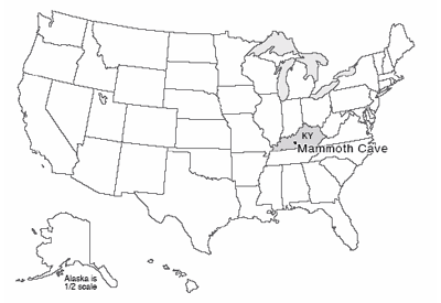
Water, Rivers, Floods, and Caves: Canyonlands, Delta and Mammoth Cave
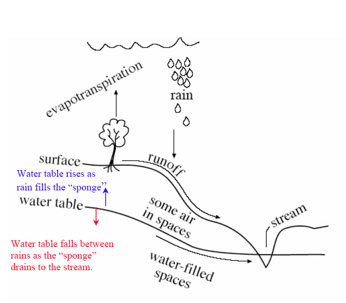
- Most of the rain that falls then evaporates, especially from plants; most of the remainder soaks into the ground.
- Soil and shallow rock usually have air as well as water in spaces; deeper, below the water table, the spaces are all water-filled.
- The water table looks like a smoothed version of the ground surface, and hits the surface at streams.
- The ground acts something like a sponge, with spaces filling during rains, and draining to keep streams running between rains.
- So, the water table rises during wet times, and sinks during dry times.
Rivers Move Rocks
- Rivers get water mostly soaking through the ground, and rocks by mass movement.
- If more rocks arrive than the water can move away, the rocks pile up, steepening the river so it can move more rocks.
- Sticky, small clay particles favor single, deep meandering channels that move suspended load up in the channels.
- Lots of sand, gravel, or larger rocks that don’t stick together favor many shallow braided channels.
Dams Make a Big Difference
- Sediment builds deltas to fill reservoirs formed by damming rivers.
- A delta builds out but also up, “backing up” sediment to bury fields and houses for some distance upstream.
- Regions downstream of dams no longer get floods after a dam is built.
- This makes a huge difference for what lives on floodplain (favors humans over nature).
- Without floods, big rocks are no longer moved by rivers.
- Clean water released by dams picks up sand, removing sand bars and affecting river ecosystems.
Ignoring rivers can be dangerous
- A delta is a big pile of sediment, which compacts under its own weight.
- The Mississippi delta is miles thick, and compacts a lot.
- The natural sinking is balanced by new mud from the annual flood.
- Humans hate mud on their carpets, so raise natural levees to keep the river out of houses.
- But sinking continues—most of New Orleans had subsided below river level, and some is beneath sea level.
- Wetlands below New Orleans have been lost as levees and dredging for shipping kept flood mud from balancing sinking.
- A low city by a high river and sea with no wetlands to slow storm surges brought huge hurricane disaster.
- Before this happened, scientists, disaster planners, many journalists, and others repeatedly warned that it was coming…
- The sinking continues; rebuilding without major changes will cause the next disaster to be even worse.
Caves are Cool
- Some rocks (esp. limestone) dissolve easily; if cracks are rare so the dissolving is focused, then sinkholes form going down from the surface, with caves beneath, springs, etc., giving a landscape called karst.
- If the cave then becomes air-filled, water dripping in will lose extra CO2 picked up from the soil, depositing dissolved limestone to make cave formations.
- Water goes through caves quickly; pollution discharged today may harm someone tomorrow.
- For other rocks, water moves much more slowly; pollution may not “get” anyone for a while, but once it does, clean-up usually is very hard and very slow.
- Scientists and engineers have developed some clean-up options, but the best option is to keep poisons out of the ground.
Textbook 6.1: Canyonlands National Park
River Processes
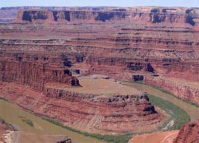
Southwest of Moab, Utah lies Canyonlands National Park. A “rough” park with few services available, little water (except for the rather muddy rivers), pot-holed roads, and awesome mountain biking, Canyonlands preserves the confluence of the Colorado and the Green Rivers. Many “visitors” to the park never actually enter it, choosing to gaze down on the Colorado from the vantage point at Dead Horse Point State Park. The two rivers of the park are incised a third of a mile (half a kilometer) or more into the red sedimentary rocks of the Colorado Plateau. Those rocks, mostly sandstones (made from sand) and shales (mud rocks, made from pieces smaller than sand), give the distinctive cliff-slope pattern of the canyons—resistant sandstones form cliffs and cap the flat-topped mesas, while softer shales form slopes.
The great Colorado Plateau, flanked by the spreading regions of the Basin and Range to the West, and the Rio Grande Rift to the east, occupies large parts of Utah and Arizona plus some of Colorado and New Mexico, and includes Zion, Bryce, Capitol Reef, Arches, Grand Canyon, Petrified Forest and Mesa Verde National Parks as well as Canyonlands, and many national monuments and other public treasures. The Colorado Plateau is noted for reddish, flat-lying, rocks from the Paleozoic of a few hundred million years ago.
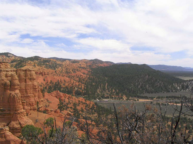
The details are not all known of how the Colorado Plateau avoided extreme deformation for hundreds of millions of years, while most of the rest of the west was being bent, broken, or erupted. The silica-rich continental rocks of the Plateau may be a bit thicker than in its surroundings, so the spreading of Death Valley was unable to tear the Plateau apart and instead jumped across to the east side of the Plateau to continue as the Rio Grande Rift (the valley in which the Rio Grande flows). The spreading even seems to have nibbled away at the Plateau, with a few big pull-apart, Death-Valley-type faults visible in places such as Red Canyon just west of Bryce (see the picture below). However, our concern here is slightly different— the role of streams.
Rain, Rocks, and Rivers
The rivers of the Colorado Plateau are nearly as well known as their parks, for great rafting, incredible scenic views, and deep canyons. The Colorado, the Green, the San Juan, the Fremont, the Virgin and others have taken their place in history. But what are those rivers doing down there in the canyons?
Simply put, a stream or river is a conduit to take excess water, and sediment, from high places to low ones and usually to the ocean. Looking first at the water, rain or snow falls on the ground. Averaged around the world, rainfall (plus snowfall after it melts) is about 3 feet per year. Pennsylvania's annual rainfall is also right near the global average, as is much of the tree-covered eastern US. Some of this water evaporates directly, but most is used by plants and then is transpired (evaporates) from them. The evaporation from plants and from other surfaces usually is lumped together and called “evapotranspiration.” In a humid temperate climate such as central Pennsylvania, roughly two-thirds of the rainfall is involved in evapotranspiration and returned directly to the sky; in dry climates, a larger fraction of the rainfall—maybe almost all of whatever rain falls—may be returned to the air by evapotranspiration.
Of the water that avoids evapotranspiration, a little actually falls on lakes or streams, and some may fall on the land surface and then flow directly and immediately over the surface into lakes or streams, especially from the surfaces that humans have covered with buildings, roads, and parking lots, thus keeping the rain from soaking in. But most of the rain that avoids evapotranspiration soaks into the ground to form groundwater.
Soils and most rocks include interconnected spaces, either gaps between grains of sand, the cracks in the rock called joints, caves, or other openings. The ground acts a bit like a sponge, with water soaking in and then slowly draining out to the rivers. We will discuss this groundwater flow a bit more when we visit Mammoth Cave, next; for now, simply note that because gravity pulls water down, rocks near the surface usually have some air in the spaces even where conditions are damp, and deeper rocks usually have all their spaces filled with water. The surface separating the rocks with water-filled spaces from those containing some air is called the water table, and where the water table intersects the surface of the Earth, a stream or lake occurs.
Rivers flow even when it isn't raining because water is slowly draining through the ground from beneath hills to the rivers. The water table rises in elevation during wet times as the “sponge” of the Earth fills up with rain, and the water table falls during dry times as the sponge drains to keep the streams flowing. And, the water table is just below the surface in valleys, actually hits the surface at streams, but you must drill deeper under ridges to penetrate the water table and complete a water well.
As we saw back at the Badlands, weather attacks rocks to produce loose pieces through the processes of weathering. And as we saw at the Gros Ventre slide in the Tetons, processes on hillslopes including soil creep and landslides deliver the loose pieces (which we can call sediment) to rivers. A river is then faced with a balancing act; it must transport both the water and the sediment delivered to it.
You may be able to think of many ways for the river to adjust if more or less water, more or less sediment, or bigger or smaller or “stickier” pieces (those more likely to clump together) of sediment are delivered. For example, if more sediment is delivered to a river than it can remove, then the sediment will pile up, raising the elevation of the bed of the river. This steepens the river—the elevation of the ocean where the river ends has not changed, but the elevation of the river bed away from the ocean is now higher—so the river flows faster and is better able to move the sediment. Deliver more water and less sediment, and the river will wash away all the sediment and have energy left over to carve into the river bed. This cutting downward will make the river less steep—because the river ends at sea level and can’t lower that, lowering the upstream reaches of the river must make the slope to the ocean less steep. A less-steep river will carry less sediment and so quit cutting its bed—the river tends to reach a balance in which it just removes the water and sediment supplied to it. In the process of reaching this balance, rivers also may adjust the width and depth of their channels as well as the steepness.
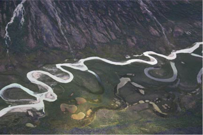
Rivers are diverse; a white-water rafter on the Youghiogheny River sees a very different setting than greets a river passenger on the Mississippi River going to New Orleans! Of the many river patterns, we often focus on two: meandering and braided (the Mississippi is a meandering river; the "Yough" has some meanders, but not nearly so well developed as the Mississippi). Whether a river meanders or is braided depends on the sediment supplied to the river as well as the water.
A river moves small sediment particles up in the water (suspended load), and larger pieces by rolling or bouncing them along the bed (bed load). If the river receives mostly small particles—what geologists call "fine-grained sediment"—the river typically will form a deep channel. Such a channel is especially efficient at transporting water, and the sediment in the water, because most of the flow is kept away from the river bed and river banks where friction with tree roots and other things slows the water. Very fine sediment—clay—can make fairly deep and steep river banks without collapsing, because the clay particles stick to each other—if you’ve ever worked with clay in art class, you know how well the clay particles stick together, and how much easier it is to make a pot out of clay than out of gravel or sand!
Such deep streams typically curve back and forth, or meander, along their paths. Put a tree’s roots in the way of the stream, and the water flow will curve around the obstacle. In doing so, the stream will race along the outside of the curve and erode it, and a meander bend will grow. (Meandering has been observed to occur without any tree roots in the way, and so is a bit more complex than just curving around obstacles.) Meandering streams usually occur in relatively flat, lowland regions towards the coast.
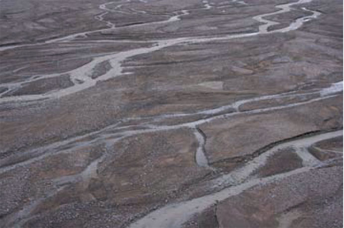
If a stream receives lots of sand and gravel or even bigger chunks, the large blocks will tend to plug, or dam, a single, deep and narrow channel. The stream then assumes a wide, shallow pattern that is efficient at rolling debris. When sand and gravel get really wet along a river bank, they cannot form steep slopes, as we saw with the mass movements in the Tetons, and the collapse of any steep slopes that start to form along a river bank contributes to having a wide, shallow stream. Within this broad stream bed, gravel (or boulder) bars often form when floods are ending and losing their ability to roll lots of sediment; the water then must flow around these bars. The splitting and rejoining of channels around bars, when viewed from above, looks something like ropes of water that have been braided together, so these are called braided rivers. They are common in upland regions, where steep mountain slopes shed landslides of coarse rocks into the channels.
Again, please recognize that this is a very simple view of stream processes. You can find meandering streams in the flat bottoms of valleys in which beaver dams have trapped mud, for example. Streams with bedrock rather than sediment in their beds often have relatively straight single channels, as do many small streams with sediment beds. The key thing to remember about a stream is that it exists to move sediment as well as water.
A tremendous example occurs a little ways downstream of Canyonlands and upstream of the Grand Canyon. The Glen Canyon Dam was built on the Colorado River in the 1960s. The dam stopped floods coming through Canyonlands from reaching the Grand Canyon—water from floods that had raged through the canyon now is stored in the reservoir and then released gradually. Several things began happening to the river once the dam was completed. The dam trapped the sediment carried by the river, and released clean water, so the reservoir is filling with sediment, and in a few centuries or less will be full. Unique fish species that thrived in the muddy waters of the Grand Canyon suddenly were easy prey for clear-water species that were introduced, so many of the native species are endangered and disappearing now.
With no floods raging down the canyon, high water no longer piled up sand in corners of the canyon to make sand bars. The clean water was able to carry some sand and smaller pieces of sediment, so the existing sand bars below the dam were slowly washed away. The many types of wildlife that depend on sand bars thus were harmed—cottonwood trees that rooted in the sand, birds that lived in the cottonwoods, deer that came down to drink from the river by standing on the sand bars rather than the rocky cliffs. Floods on un-dammed side streams continued to dump large rocks into the Colorado, but the Colorado lacked the high flows to move this material onward, so the rapids at the mouths of side canyons began to steepen.
In the spring of 1996, an artificial flood was released from the dam to attempt to re-balance the system. Indications are that this flood was a partly successful experiment, rolling some of the big rocks out of the rapids at the mouths of the side streams, freeing sand trapped beneath, and forming that sand into bars. But, those bars weren’t very big and didn’t last very long. Additional human-made floods were released in 2004 and 2008, timed to occur when natural floods coming down side streams were delivering additional sediment, to help make bigger sand bars. Additional attempts may be made. Such human-caused floods cost money (lost hydroelectric power when extra water is routed around the hydroelectric plant in the dam to get water into the river in a hurry) and require lots of planning (you need to warn people camping or hiking in the Canyon before you suddenly flood them out!), and they can never get the Canyon back the way it was originally, but the artificial floods do seem to have helped restore some of the sandbars that are so critical for wildlife.
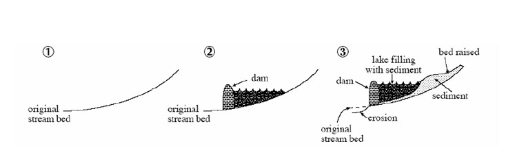
Meanwhile, upstream of the dam, as sediment builds up to fill the reservoir, sediment will also accumulate along the river upstream of the reservoir. There aren’t many people living there, but if there were, their fields and houses would begin to be buried by mud. A river slows down as it enters a reservoir, or any other lake or the ocean, and sediment is dropped from the slowing water. Unless strong waves and currents in the reservoir or ocean take that sediment away, a pile called a delta forms. But, the delta cannot be perfectly flat on top. If it were, then the stream would drop its load when it hit the flat spot and slowed down, and that would raise the flat spot. So, as the delta grows into the lake, the upstream end of the delta must build up so that the river still flows downhill, and that, in turn, will cause sediment to build up for some distance upriver (see the figure below).
The troubles with the dam on the Colorado at Glen Canyon are not unique. Reservoirs immediately start filling with sediment, and so cannot last forever. This filling contributes to deposition of sediment upstream, which may bury houses or fields. The clean water released tends to pick up fine-grained sediment below the dam, but the lack of floods means that the river is no longer able to move coarse-grained sediment. Hence, the river bed is changed, affecting species that lived there. The lack of floods often has huge effects on the plants and animals that live along the river; what had been a region reserved for wildlife adapted to the changing water levels and channels becomes a place for humans to settle in the shadow of the dam.
When two dams were built on the Elwha River, which flows north from Olympic National Park, the dams contributed to blocking salmon runs, to washing away the sand and gravel in which the salmon had spawned downstream of the dam sites, and to turning an annual “flood” of 300,000 salmon into a trickle of barely 3,000 salmon. (A fish hatchery was built instead of fish ladders around the first dam, but the hatchery was quickly abandoned.) Once the spawning bars were washed away below the dam, the river quit delivering sediment to the beaches of the Strait of Juan de Fuca (an arm of the Pacific Ocean); as the beaches washed away, the native peoples were no longer able to carry on their traditional shell-fishing, and engineering was required to protect the nearby harbor of Port Angeles, which was no longer guarded by sediment-fed bars. In an ambitious plan to help the beaches, the river, the salmon and the park, the federal government purchased the dams. One was removed in spring of 2012, with the second slated to follow quickly. The river, beaches, harbor and more will take a while to get back to "normal," because so much was changed by the dams, but there is much optimism about the recovery. You can read more, and track the progress, at the official website for Olympic National Park.
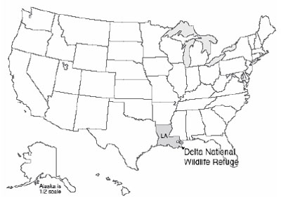
Textbook 6.2: The Delta National Wildlife Refuge
Controlling Rivers
At the tip of the Mississippi Delta lies the Delta National Wildlife Refuge. This is one of several wildlife refuges along the Gulf Coast that, in addition to spawning a great range of resident wildlife, draw migrants from the north. Ducks and geese, herons and cranes, gallinules and rails, the wetland birds of most of a continent stream in through the fall, and then spread north again in the spring. (Yes, technically, a National Wildlife Refuge is not a National Park, but it is a national park, so we’ll cheat a little and use it—it makes a good story. And, it is just down the river from the wonderful bayous of the Barataria Reserve in the Jean Lafitte National Historical Park and Preserve—be sure to stop if you're in the area!)
Unfortunately, these wetlands are disappearing at an astonishing rate, because of the indirect effects of human activities. Estimates are that every year Louisiana is losing over 100 square kilometers of wetlands (equal to loss of a square with sides more than six miles long). Whether the wetland birds will continue to stream north for generations to come may depend on how humans respond to the challenge.
The Mississippi Delta is a massive pile of mud and sand from the Rockies and Appalachians, transported by the river and dumped into the Gulf of Mexico. The Gulf used to extend far into the heartland of what is now the U.S.; over the last 70 million years, the delta has grown southward from near Cairo, IL (up by St. Louis), until now the former embayment has been turned into a projection from the end of Louisiana into the Gulf. There, the delta is as much as seven miles thick. If you have ever watched mud settle in a bottle of water, or if you have observed how your boot packs mud down if you step in it, then you know that, over time, mud will compact under its own weight or under the weight of anything placed on it.
As the delta grew into the Gulf over the millennia, a natural balance was reached. The compaction that occurred during a year would leave a little space at the top, but the springtime floods would bring new mud to fill the space. Trees and other vegetation would grow up through the new sediment, or re-seed on top, and the system would continue, wildly productive and vibrantly green.
Wrestling with Mud
There is a problem with this system and humans, however. Many people have settled near the river. Plants can grow up through the mud of floods, but people don’t enjoy having their houses slowly fill up with mud. So, humans have built control structures. We built dams upriver, which trap sediment behind them and which hold some floodwaters in check. Because large floods threaten dams and must be let through, we also built levees along the river in its downstream reaches, great walls that hold the river in. We also dredge the river, deepening it to carry the water—and shipping. The great floods that shoot down the river then do not spread over the floodplain and the delta, depositing fertile sediment to fill the space left by compaction of mud, but instead are piped to the Gulf, where the sediment jets off the edge of the delta to settle in mile-deep water.
Way back in 1996, when the very first edition of this textbook was written, it read:
"Today, much of New Orleans, which does lie on the delta, is well below sea level. A tanker in the river between its levees is higher than the playing field of the Superdome. Rainfall, and water seeping from the river, must be pumped out so that the city doesn’t fill with water. If the pumps were to fail, the city would become a lake. The city steadily sinks deeper, and the levees are steadily raised by the Army Corps of Engineers, as instructed by Congress, to keep the river caged. Meanwhile, the wetlands of the delta, unnourished by new sediment, are sinking beneath the Gulf..."
After 2005, we know how terribly accurate the geological understanding of New Orleans really was. Where natural wetlands should have slowed the waves from Hurricane Katrina (which was not a really big storm by the time it got to New Orleans!), the high waters of the storm surge roared unimpeded from the Gulf. Parts of the levees failed. The pumps failed. The city filled with water, as much as 20 feet deep.
The hurricane showed what geologists (and emergency planners!) had long known, and had long told Congresspersons and Senators and students and others—New Orleans was a disaster waiting to happen, not “if” but “when.” With almost 2,000 people killed, hundreds of thousands of people displaced, and damages approaching $100 billion (that is, more than $300 from every single person in the United States), the danger of ignoring solid scientific evidence and hoping for the best is clearer than ever.
But, the city is rebuilt where it was, the sinking will continue, the loss of wetlands will continue unless many things are changed, and the levees will need to be raised. With the likelihood that the strongest storms will get stronger and sea level will rise in the future (we’ll revisit this later in the semester), the scene will be set for an even more horrific disaster at some future date. Many options are available, including restoring wetlands, filling parts of the city with debris or other materials, moving construction to higher parts of the city, moving out entirely, and more; it will be interesting to see how much of this will be done. But primarily, the donations and tax dollars from the rest of the country after the 2005 disaster were used to rebuild the city directly in harm’s way, with the knowledge that the rest of the country will once again foot the bill when disaster strikes.
Another story is being played out in this region as well. The river wants to leave New Orleans. The city has a love-hate relation with the river, fearing the floods but needing the drinking water and the shipping channel. The river can harm the city rapidly by flood, or slowly by leaving.
To understand this tendency of the river to leave New Orleans, note that especially large, muddy, flood-prone rivers normally have natural levees (which are much lower than the human-made ones). When a flood happens, the water spreads out of the main channel onto the flood plain, the flattish region of river-deposited muds next to the main channel. As the water spreads out into the trees or houses of the flood plain, the flow slows, and the water drops some of its muddy load. Just as the water leaves the main channel, the water is carrying the most load, and the slowing is most prominent, so most of the load is deposited right there next to the channel. Hence, the mud layer from a flood is thicker next to the river than farther away, forming a natural levee. Humans have raised these natural levees in many places.
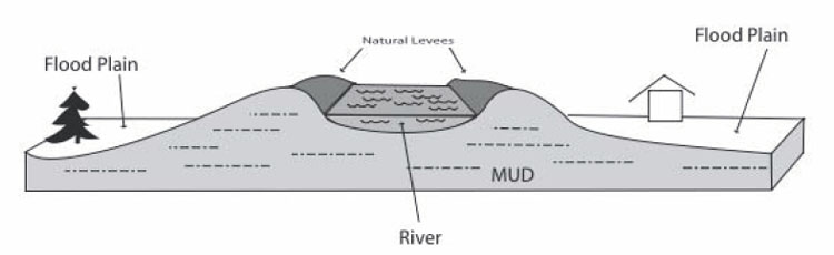
When we discussed reservoirs, we saw that the delta of sediment formed when a river enters a lake must build up as well as out, so that the river still flows downhill into the lake. The same is true for a river entering an ocean. The Mississippi River, with its levees, naturally dumps mud into the Gulf of Mexico, slowly lengthening and raising the river bed. After a while, the river is a bit like a log flume in an amusement park, following a long path to the Gulf; a break in the levee wall would allow a much steeper, shorter, and more exciting downhill trip. The recent history of the Mississippi Delta is that, roughly every 1,500 years, the main outlet of the river has broken through the natural levee, like a log full of park-goers breaking through a curve in the ride, and the river has then followed that new shortcut. But, as mud is deposited along that new shortcut, it lengthens until it is like a long log flume, and then the river breaks through a side again.
During the 1940s and 1950s, the Mississippi started to break out, into a side stream called the Atchafalaya River. To save the shipping channel and the water supply for New Orleans, the Army Corps of Engineers has used the Old River Control Structure and other dams and levees to allow some water to go down the Atchafalaya while keeping a vigorous flow in the main log-flume channel past New Orleans. During a flood in 1973, the Corps very nearly lost the Control Structure, and the river, when a giant whirlpool undercutting the dam came close to causing it to collapse. The task of the Corps is very difficult, taming immense natural forces as the system becomes more and more out of balance.
(An excellent account of this is given in John McPhee’s book The Control of Nature, 1989, Farrar, Straus and Giroux, New York, which may be a little out of date but is still fascinating, and shows that policy-makers and others were warned about the dangers in the area long before the disaster of the 2005 hurricane.)
Textbook 6.3: Mammoth Cave
Deep beneath the rolling Kentucky hills lies Mammoth Cave. With about 390 miles (almost 630 km) of surveyed passageways, this is the longest known cave in the world, more than twice as long as second-place Jewel Cave (which is in a national monument in South Dakota, and has just under 160 miles or 260 km of surveyed passageways). The great size was achieved when a team of explorers showed that the historical part of Mammoth Cave and the even larger neighboring Flint Ridge Cave were actually connected, followed by a lot more surveying. There is every reason to expect that further connected passages remain undiscovered, and estimates extend as high as 1000 miles of total passageways.
The cave was mined for saltpeter (containing nitrates) for use in gunpowder, especially during the war of 1812. The source was bat guano (the polite name for it) deposited over the ages by great flocks of bats. Native Americans used the cave long before European settlement.
Cave Formation
The cave was dissolved in limestone. The limestone was deposited in shallow seas during the Paleozoic (a few hundred million years ago), mostly as shells of sea creatures. The limestone lies beneath sandstone from old beaches. The sandstone is a rather sturdy layer, and provides a “roof” that does not collapse easily, which is important in making Mammoth Cave so big.
As we saw in discussing rock weathering to make muds for the Badlands, rainwater and soil water are weak acids. Chemically, limestone is calcium carbonate, which is especially prone to attack by acid. The usual test for limestone is to drip a little weak hydrochloric acid on a sample; limestone fizzes vigorously as the rock decomposes, freeing carbon dioxide gas, but most other rocks react much more slowly and do not fizz. Where soil waters move through limestone, the rock dissolves and washes away rather rapidly. If the rock has lots and lots of cracks, the water may follow so many different paths and spread out the dissolution so evenly that caves are not formed. But if the limestone has just a few cracks for water to flow through, all of the dissolution will be concentrated in those few places, and cave passageways may form. Then, if the water table is lowered (say, because the nearby river has cut downward through rocks and is draining water from the rocks to its new lower elevation, as Kentucky’s Green River has done near Mammoth Cave), water will drain away and the cave will fill with air.
The beautiful stalaCtites (from the Ceiling), stalaGmites (on the Ground), and other cave formations can then develop. Because processes in soil—worms exhaling, and similar activities—typically release carbon dioxide, groundwater usually contains more carbon dioxide than does rainwater, so groundwater is more effective than rainwater at dissolving limestone. Occasionally, a cave may be so isolated from the surface that dangerous levels of carbon dioxide exist in the cave, but caves usually exchange enough air with the outside world to have near-normal levels of carbon dioxide. When groundwater drips into a cave that has a near-normal carbon-dioxide level, the water loses carbon dioxide to the air. The water then cannot hold all of the dissolved limestone, and deposits some of it to form the beautiful stone features we see.
Sometime, look at a cliff or road cut (but be careful—we don't want to lose anyone to distracted driving, or being run over along a roadside!). If you look carefully, you should see that almost all cliffs and road cuts have cracks (called joints), and that some of those joints are usually vertical; very often there are two or more sets of vertical joints, perhaps with many joints oriented north-south but many others oriented east-west. Rainwater that is not used by plants will trickle down the “pipe” where the joints intersect. If the rock around the pipe is limestone, the rock will dissolve, leaving space, although that space may fill with mud. Such a hole, whether mud-filled or air-filled, is called a sinkhole.
Sinkholes formed by downgoing waters are very common in the State College, PA area, where Dr. Alley lives. Penn State’s Geosciences Department is housed in the Deike Building, which required extra funding for special strengthening because the building has sinkholes beneath—a building can rest firmly on bedrock, but tends to fall into air-filled or mud-filled holes. Extra funds were similarly expended to strengthen the nearby Mt. Nittany Middle School, the runway extension at the airport, and other construction projects in the area. A newly constructed storm-water catch basin at the airport filled with water during the first rain, and the weight of the water blasted mud out of a buried cave passageway somewhere beneath, suddenly turning Spring Creek red with trout-choking sediment.
Where sinkholes and caves are common, streams often disappear underground into swallow holes, only to re-emerge at springs. Spring Creek is aptly named, and many other similar features occur around central Pennsylvania, around Mammoth Cave, and in other such regions. Corn cobs once were dumped in a sinkhole behind a cannery at Old Fort east of State College, and after a rain would pop out of a spring in Spring Mills, a few miles away. Regions with sinkholes, caves, springs, swallow holes, etc., are referred to as karst, after a region in Slovenia with many such features. Karst features are present across 20% of the Earth’s surface, and roughly 40% of the US population obtains drinking water from karst, according to the National Park Service.
In the past, people often threw trash into sinkholes. Big pieces would sink into the mud or fall into cave passages beneath, “disappearing.” When Dr. Alley was in high school and went to Sloan’s Valley, Kentucky to go wild caving (spelunking), one of the cave entrances was known as the Garbage Pit, which led into the Tetanus Tunnel. A commercial cave near Mammoth Cave was forced to close in the 1940s because of the stench from sewage draining in.
Slowly, we are learning just how stupid it is to dump things in sinkholes. A test run by Penn State’s hydrogeologist, the great Dick Parizek, during the building of the Nittany Mall showed that a little harmless dye dumped in a sinkhole near the mall came out in a nearby trout stream in a day or two. It should be evident that anything else dumped in a sinkhole near the Nittany Mall (or many, many other sinkholes in the region and in other karst regions) would show up very quickly in the water used by people and wildlife.
Dr. Alley lives in a house served by the Lemont Water Company, which is now well-known for fine water. But many years ago, before a reorganization of the water company, the intestinal parasite Giardia showed up in Lemont well water. Giardia causes intense and possibly dangerous gastric discomfort, and is to be avoided. Giardia usually is restricted to surface water; the spaces in most rocks are small enough to filter out the Giardia cysts before they reach a well, or the water takes so long to go from the surface to a well through the small spaces that the cysts die of old age on the way. At the long-ago community meeting to discuss the water contamination, company officials noted that they had installed well filters to remove sticks, leaves, etc., that came out of the wells with the water. In karst country, surface water can become groundwater and return to the surface in hours or days. Whole streams go down and up, and if sticks can go through, microscopic cysts can, too. Clearly, contaminants dumped somewhere today can be poisoning someone tomorrow.
In some other regions, the groundwater-contamination problems are quite different. In sandstones, for example, the water moves slowly, pore-by-pore, through the rocks. In some places, the water can be shown to have first entered the ground during the ice age, more than 20,000 years ago, or even earlier. Contaminants dumped in such rocks may not bother people for a while. But, when the contaminants do start to bother people, clean-up can be very difficult.
Try this experiment. Squirt some soap on a sponge, and squeeze the sponge a few times to distribute the soap well. The sponge is our rock, and the soap is the contaminant. Now, wet the sponge, hold it up, and squeeze it. Foamy, soapy water will come out. Wet the sponge again, squeeze it again, and more soap comes out. Repeat, and repeat, and repeat. You may need ten or more times to remove enough soap that you no longer see it, and sensitive instruments would detect the soap through dozens or even hundreds of additional washings. Now, suppose that we had not soap, but a chemical that causes cancer in humans. If the water in the rocks naturally is hundreds or thousands or more years old, then nature takes a long time to wash out the rocks once, and washing them out ten or one hundred times will take much longer than all of human history.
There are things that can be done about groundwater pollution. You can pump clean water in and dirty water out, or pump steam or hot water in and out (and then try to figure out how to clean the dirty water or steam once you have them on the surface). People are experimenting with installing filters so that polluted water will flow through them, sometimes using large masses of iron filings to react with and break down some organic chemicals in groundwater. Geomicrobiologists are prospecting really dirty sites for “bugs” that “like” to eat pollutants, and then trying to introduce those microorganisms into other polluted sites; other biologists are looking into ways to design pollutant-eating microbes. But, such techniques usually are very expensive and not very effective. Most people who have thought about it agree very strongly that the best way to handle groundwater pollution is to keep the chemicals out of the ground in the first place. A whole lot of money has been spent on clean-up because we did not learn that lesson soon enough—and there are days when it appears that we have not yet learned that lesson.
Virtual Field Trips
Join Dr. Alley and his team as they take you on "virtual tours" of National Parks and other locations that illustrate some of the key ideas and concepts being covered in Unit 6.
TECH NOTE - Click on the first thumbnail below to begin the slideshow. To proceed to the next image, move the mouse over the picture until the "next" and "previous" buttons appear ON the image or simply use the arrow keys.
Virtual Field Trip #1: Canyonlands
Rivers Roll Rocks, and Dams Get in the Way. All photos by R. Alley from the Penn State CAUSE trip, 2004
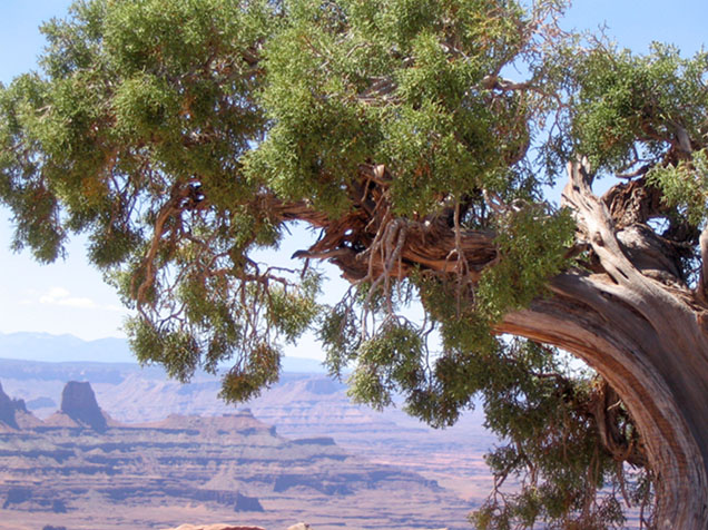
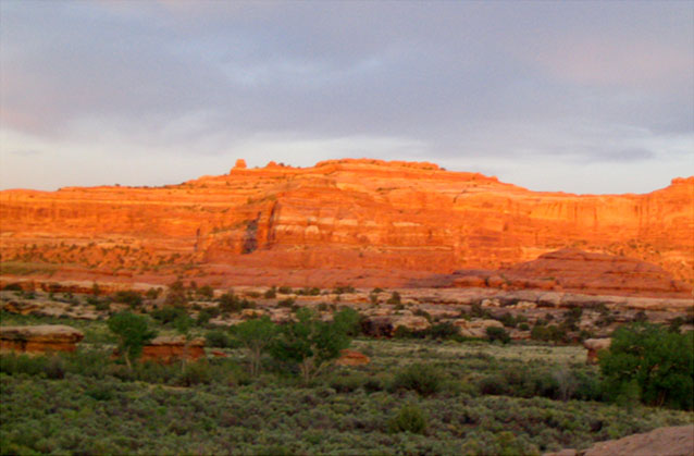
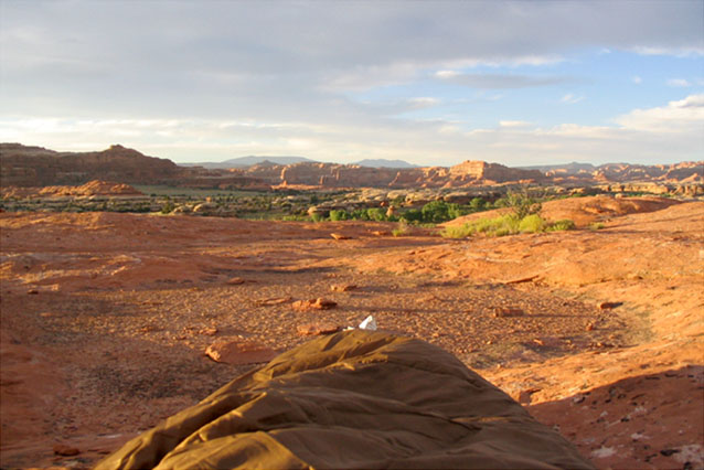
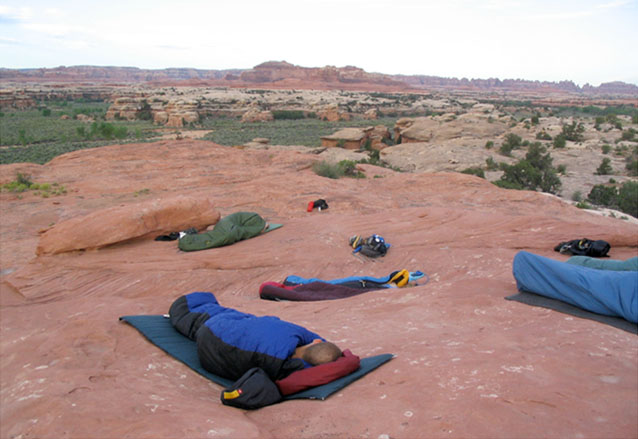
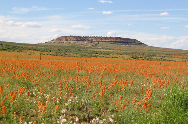
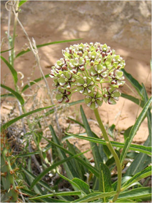
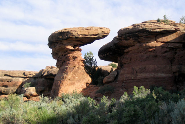
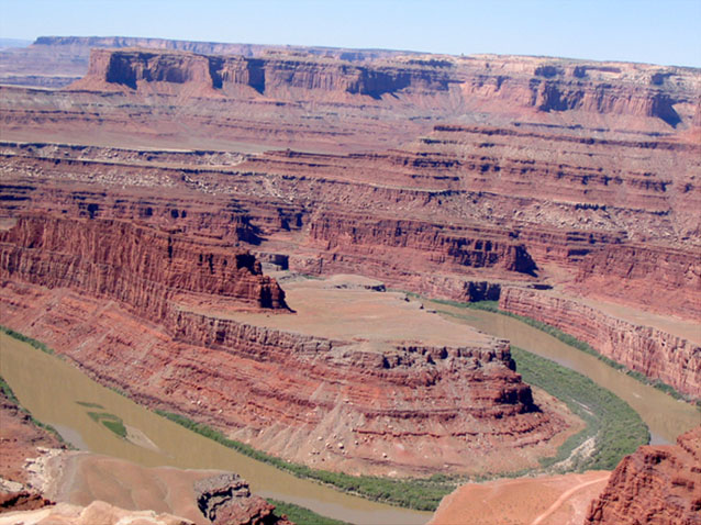
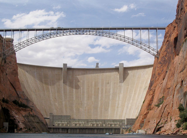
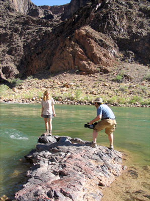
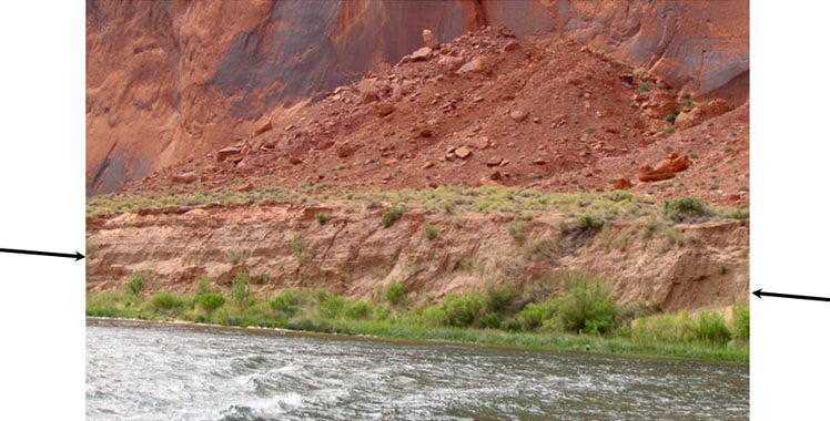
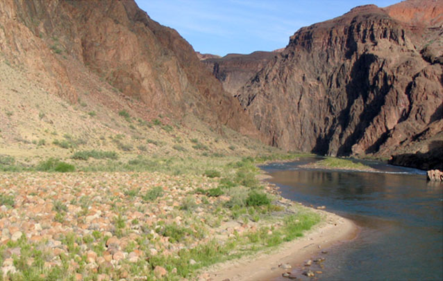
Image 1: Canyonlands to the Grand Canyon; Rivers Roll Rocks, and Dams Get in the Way; All photos by R. Alley from the Penn State CAUSE trip, 2004.
Image 2: Canyonlands, near Moab, Utah, preserves the junction of the Colorado and Green Rivers. The rocks are mostly from the Mesozoic (a couple of hundred million years ago) and include sandstones and shales.
Image 3: Sunrise over the red rocks of Canyonland in the Needles area. Sunrise washes the red rocks of Canyonlands in the Needles area, one of several distinct districts of the park--the rivers are not bridged, so getting from one district to another can take a lot of driving.
Image 4: Sunrise at Needles area campground in Canyonlands with foot of sleeping bag in foreground. Sunrise over sleeping bag, Needles area group campground, Canyonlands.
Image 5: Several students in sleeping bags on the rocks at Needles area campground, Canyonlands. Sunrise over sleeping students, Needles area group campground, Canyonlands.
Image 6: A field of orange mallows at the entrance to Needles area in Canyonlands. A field of mallows, entrance to Needles area, Canyonlands.
Image 7: Close-up of a desert milkweed in Canyonlands National Park. A desert milkweed, Canyonlands National Park
Image 8: Close-up of large uniquely shaped and patterned sandstone in Canyonlands. Rock features, Canyonlands. The sandstones shown here have weathered into fantastic patterns.
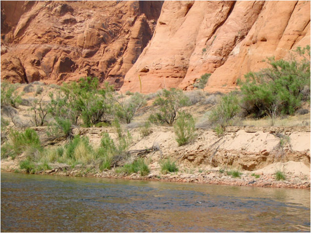
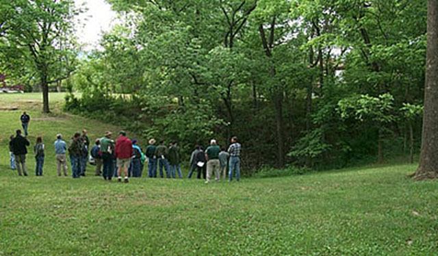
Image 9: Panoramic view of Canyonlands and a muddy Colorado River with exposed sandbars, viewed from Dead Horse Point State Park. The Colorado River and Canyonlands, as viewed from Dead Horse Point State Park. Notice the muddy water, the sand bars in the river, and the tree-covered sand bars along the river. This clearly is a river that moves much sediment.
Image 10: The Glen Canyon dam and highway bridge, viewed from a raft on the Colorado River below the dam. The Glen Canyon dam, and highway bridge, viewed from a raft trip on the Colorado River below the dam. Lake Powell, on the other side of the dam, catches the sediment from the river, so that clean water is released from the dam.
Image 11: A young woman and a man with a video camera standing on a rock in the river, at the bottom of the Grand Canyon. Stephanie Shepherd and Topher Yorks filming at the bottom of the Grand Canyon. Notice that the water behind them is nearly free of sediment, so you can see the bottom clearly in the closer parts.
Image 12: Colorado River, below the Glen Canyon Dam, with arrows pointing to an eroding sandbar. The Colorado River below the Glen Canyon Dam. The cliffs are still spectacular, but the sandbar across the center (arrowed) has largely been eroded away by the sediment-free waters released from the dam.
Image 13: Bottom of the Grand Canyon, boulder bar in left foreground and river with clear water in right foreground. Bottom of the Grand Canyon, from the silver bridge that takes the Bright Angel Trail across the river. The water is clear. The left foreground shows a boulder bar, not a sand bar--much of the sand has been washed out of the Canyon by the clean water released from the dam upstream.
Virtual Field Trip #2: Mississippi Delta National Wildlife Refuge

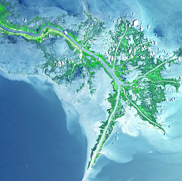 The Mississippi River flows from the upper left through green marshes to the blue Gulf of Mexico, where the river's mud colors the water whitish. Branches of the river have been deepened for shipping; the main channel extends to the southwest (lower left). Deltas come in many forms; this is somewhat different from those we saw earlier in Greenland. Source: http://photojournal.jpl.nasa.gov/catalog/PIA03497
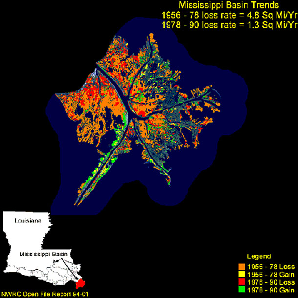
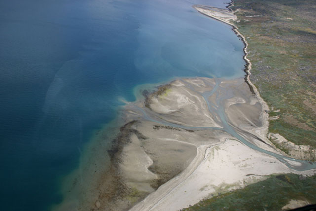
Image 1: Aerial view of Mississippi Delta. Mississippi River flows through green marshes to Gulf of Mexico and river’s mud clouds water. Deltas, rivers and floods: living with the moving water. This picture shows the Mississippi River Delta, south of New Orleans. Plants are green, deep water is blue, and the grayish-white is mud carried by the river. A few poofy white clouds are also visible.
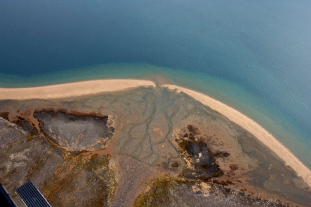
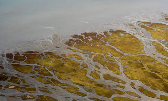
Image 2: Aerial view of delta in Mudder Bugt (“Muddy Bay”), east Greenland. Stream at bottom of photo deposits the delta into fjord at top of photo. Delta in Mudder Bugt (“Muddy Bay”), east Greenland. A stream flowing from the bottom of the picture has deposited the delta into the fjord at the top of the picture. Sediment supply is slow enough to allow waves in the fjord to rework the sediment to make the beaches that outline the delta. Helicopter skid is visible in the far lower left.
Image 3: Aerial view of delta near Muddy Bay, Greenland. Stream flows in braided pattern and there are icebergs offshore. A delta near the one in the previous picture. The stream, flowing from the lower left, is braided, and the pattern of sand bars and beaches is quite interesting. This is Greenland, so the objects offshore are icebergs rather than oil tankers or merchant ships.
Image 4: Aerial view of a Greenlandic delta, near Muddy Bay, shows sand bars and braided rivers. Another Greenlandic delta, close to those in the two previous pictures. Some of the bars in the braided river supplying the delta have been stable long enough for tundra vegetation to become established.
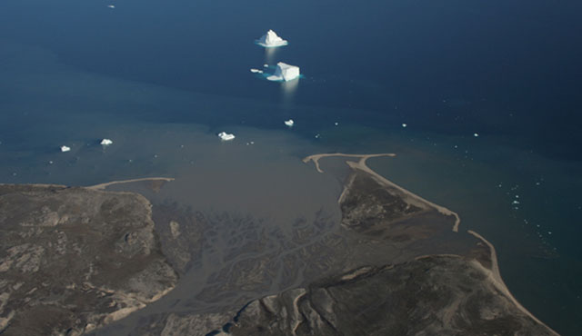
Image 5: Aerial view of two side-by-side deltas in Tasermiut Fjord, South Greenland. Deltas are higher on the right, where the streams enter. Two more deltas, Tasermiut Fjord, South Greenland. Careful examination will show that the deltas are higher on the right, where the streams enter, and lower on the left--sediment builds up as well as out.
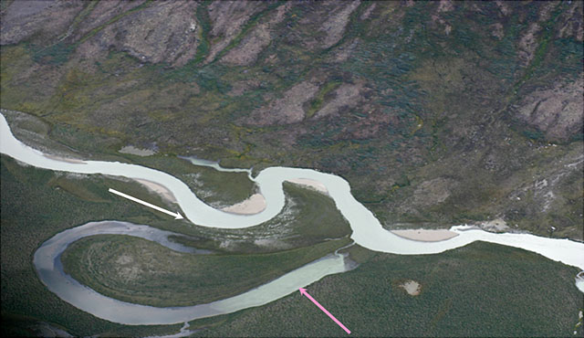
Image 6: Aerial view of stream Sondresermilik Fjord, S. Greenland. One arrow points to oxbow lake, one points to levees separating stream from lake. Meandering stream feeding Sondresermilik Fjord, South Greenland. Streams flow fastest on the outside of a curve, eroding the curve, until a shortcut forms and leaves an oxbow lake (pink arrow). Low natural levees (white arrow) separate the oxbow lake from the stream.
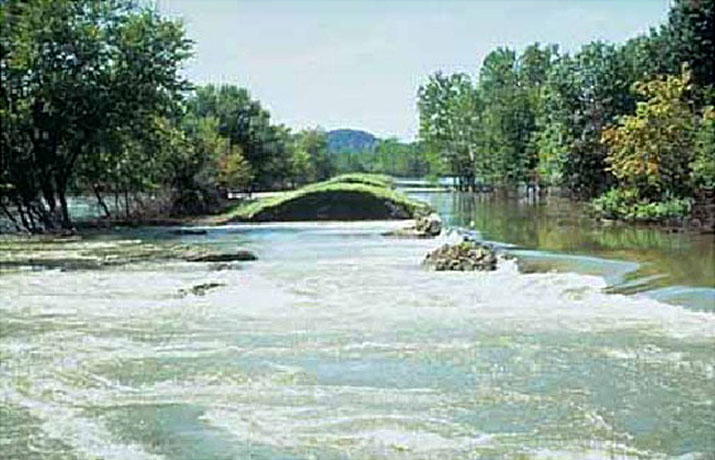
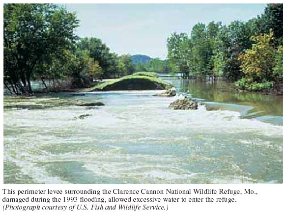
Image 7: Failed Missouri levee in the Mississippi basin, during the Great Midwest Flood of 1993. http://water.usgs.gov/nwsum/WSP2425/images/levee.jpeg US Fish and Wildlife Service photo, from Effects of the Great Midwest Flood of 1993 on Wetlands, by James R. Kolva, U.S. Geological Survey. This Missouri levee failed during 1993 flooding in the Mississippi Basin. Many (but not all) artificial levees rest on much smaller natural levees.
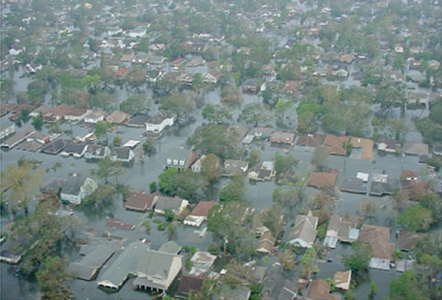
Image 8: Aerial view of flooded New Orleans after Hurricane Katrina 2005. Rooftops and tree tops surrounded by water. http://www.mvd.usace.army.mil/hurricane/chr.php Miscellaneous Photos coe_5, US Army Corps of Engineers. Flooding from Hurricane Katrina, New Orleans, 2005. Levee failure triggered this disaster.
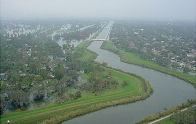
Image 9: Aerial view of Mississippi River in New Orleans and the levees that held up during Hurricane Katrina. http://www.mvd.usace.army.mil/hurricane/chr.php Miscellaneous Photos coe_6, US Army Corps of Engineers. Flooding from Hurricane Katrina, New Orleans, 2005. The levees held on the waterway shown here; the floodwaters outside came through a different levee, and are actually lower than the water between the levees seen here.
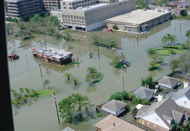
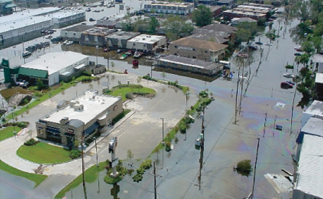
Image 10: Aerial view of Hurricane Katrina flooding in New Orleans. Muddy waters surround homes and businesses. http://www.mvd.usace.army.mil/hurricane/chr.php Miscellaneous Photos coe_17, US Army Corps of Engineers. Flooding from Hurricane Katrina, New Orleans, 2005. A very waterlogged Wendy’s outlet is visible in the left center. The muddiness of the water is also evident.
Image 11: Aerial view of Hurricane Katrina flooding in New Orleans. Oil slick can be seen on water surrounding homes and businesses. http://www.mvd.usace.army.mil/hurricane/chr.php Miscellaneous Photos coe_20, US Army Corps of Engineers. Flooding from Hurricane Katrina, New Orleans, 2005. The colors on the water indicate an oil slick. The floodwaters raced through houses, gas stations, repair shops, chemical plants and more, releasing many toxic chemicals.
Image 12: Aerial view of Mississippi Delta. Mississippi River flows through green marshes to Gulf of Mexico and river’s mud clouds water. The Mississippi River flows from the upper left through green marshes to the blue Gulf of Mexico, where the river’s mud colors the water whitish. Branches of the river have been deepened for shipping; the main channel extends to the southwest (lower left). Deltas come in many forms; this is somewhat different from those we saw earlier in Greenland.
Image 13: Map of Mississippi Delta, showing that most of the delta has sunk beneath the sea over recent decades because of human actions. Orange indicates land loss from the Mississippi Delta between 1956 and 1978, red is loss 1978-1990, yellow shows gain 1956-78 and green shows gain 1978-1990. Losses dominate, although sedimentation has been lengthening the “log flume” of the main shipping channel extending to the southwest (lower left). Loss slowed after 1978 because most of the land was already gone.
Virtual Field Trip #3: Bayou, Barataria Preserve, Jean Lafitte National Historical Park and Preserve, Louisiana.
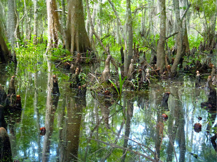
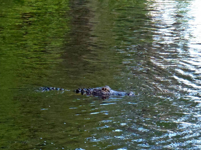
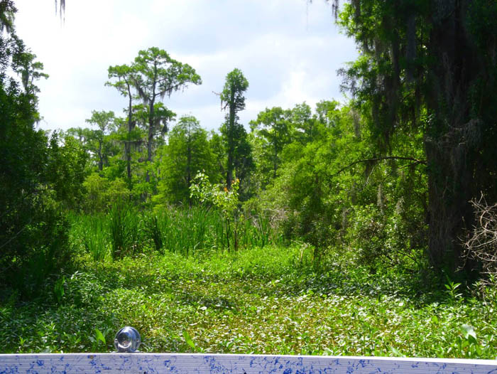
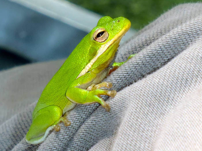
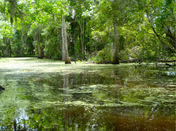
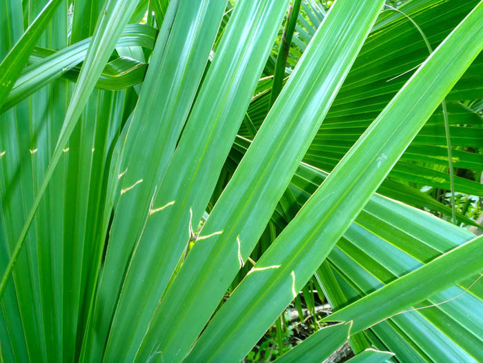
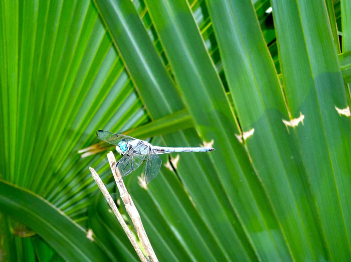
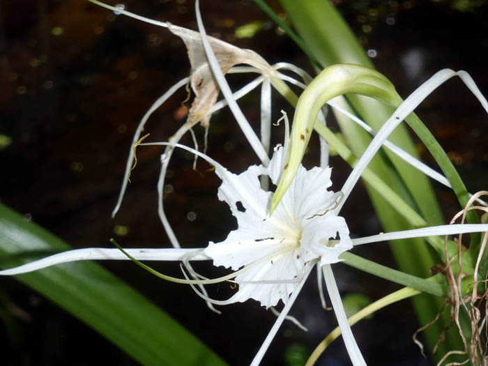
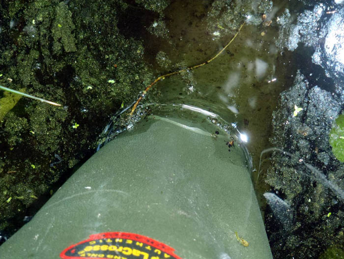
Image 1: Cypress trees in a bayou, Barataria Preserve, Jean Lafitte National Historical Park and Preserve, Louisiana. Many trees in wetlands grow “knees”, projections sticking up from the roots, that help stabilize the trees and may help the tree roots “breathe” when they are underwater. You can see such knees on the cypress trees in the bayous of Barataria Preserve, in Jean Lafitte National Historical Park and Preserve on the Mississippi Delta in Louisiana, a great place to see lots of things growing. All pictures in this slide show are by R. Alley unless otherwise indicated.
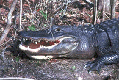
Image 2: Alligator in the bayou. Of course there are alligators in the bayou! Barataria Preserve, Jean Lafitte National Historical Park and Preserve, Louisiana.
Image 3: View of bayou plants taken from an airboat. Taken from an airboat (you can see the boat in the bottom of the picture), Barataria Preserve, Jean Lafitte National Historical Park and Preserve, Louisiana. There is water under the plants straight ahead, and that is where we went.
Image 4: A green frog sitting on Dr. Alley’s knee . This frog was sitting on my knee after we air-boated through a particularly dense patch of plants. Barataria Preserve, Jean Lafitte National Historical Park and Preserve, Louisiana.
Image 5: Bayou -- water with large trees growing out of it. Barataria Preserve, Jean Lafitte National Historical Park and Preserve, Louisiana.
Image 6: Palmetto plant in the bayou Palmetto. Barataria Preserve, Jean Lafitte National Historical Park and Preserve, Louisiana.
Image 7: Close-up of channels in limestone inside Mammoth Cave. Dragonfly on palmetto plant.
Image 8: White spider lily plant in the bayou White spider lily, Barataria Preserve, Jean Lafitte National Historical Park and Preserve, Louisiana.
Image 9: Dr. Alley’s boot in the bayou water. There is oily “scum” floating on the water. Richard Alley’s boot in water, Barataria Preserve, Jean Lafitte National Historical Park and Preserve, Louisiana. Notice the oily “scum” floating on the water to the upper right of the boot. A place such as this bayou grows LOTS of plants, which die and sink. In the mud, oxygen is scarce. The decaying plants are not “burned” efficiently in the low-oxygen environment, and some of the formerly living material produces oil. Oil mostly comes from dead algae, coal from dead woody material, and natural gas (methane) from both. Most of the oil and gas float up and escape to the surface, as seen here. In some times and places, some of the oil and gas are trapped in mud. We humans are spending a few hundred years using the oil, gas and coal that have been saved up by nature over a few hundred MILLION years, so we’re using them about a million times faster than nature saved them.
Image 10: Bubbles in the bayou. Barataria Preserve, Jean Lafitte National Historical Park and Preserve, Louisiana. Notice the bubbles in the bayou. These are “swamp gas”, which is methane, and is also called natural gas. As described with the previous picture, the gas that is made naturally and doesn’t escape is what is now being “fracked” from shales under Pennsylvania and other states.
Virtual Field Trip #4: Mammoth Cave
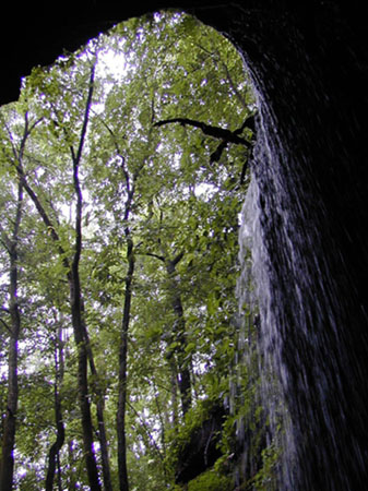
Waterfall into historical entrance of Mammoth Cave. National Park Service Photo. All pictures in this slide show are by R. Alley unless otherwise indicated (as for this one).
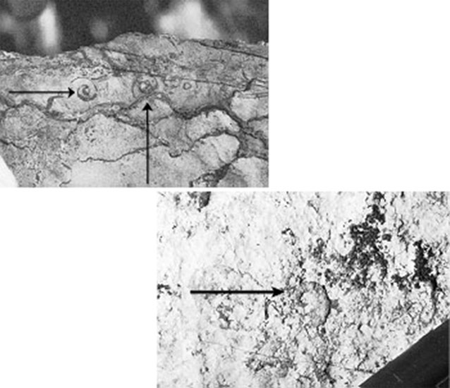
bymap/gastropod&operculae.htm USGS Photo Fossil snails (gastropods) in limestone, Cades Cove, Great Smoky Mountains National Park. Most caves and sinkholes are in limestone, and most limestone started out as shells or skeletons of marine creatures. Many shells are so broken as to be unrecognizable, but quite pretty fossils can be found.

smoky/ResearchAreas/smokys/
cadesCove/GISData/bymap/sinkholes.htm USGS photo Sinkholes in limestone near Gregory’s Cave, Cades Cove, Great Smoky Mountains National Park. Similar scenes are common along the Appalachians in many places. Soil, rocks, leaves, etc., fall into such holes, yet the holes are not full, indicating that materials are sinking toward the groundwater.
Image 1: View looking out of Mammoth Cave with waterfall to the right of entrance and green forest straight ahead. Mammoth Cave: A World Unknown to Daytime--That May Matter to Your Drinking Water Waterfall into historical entrance of Mammoth Cave. National Park Service Photo. All pictures in this slide show are by R. Alley unless otherwise indicated (as for this one).
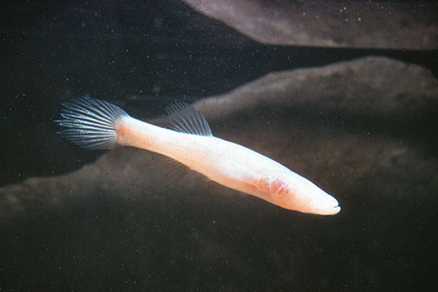
Image 2: Close-up of small, salmon-colored, eyeless fish in cave waters. http://photo.itc.nps.gov/storage/images/maca/EYELESSF.JPG National Park Service Photo. Many cave creatures are uniquely adapted to their environment, which may seem strange to us but is normal to them.
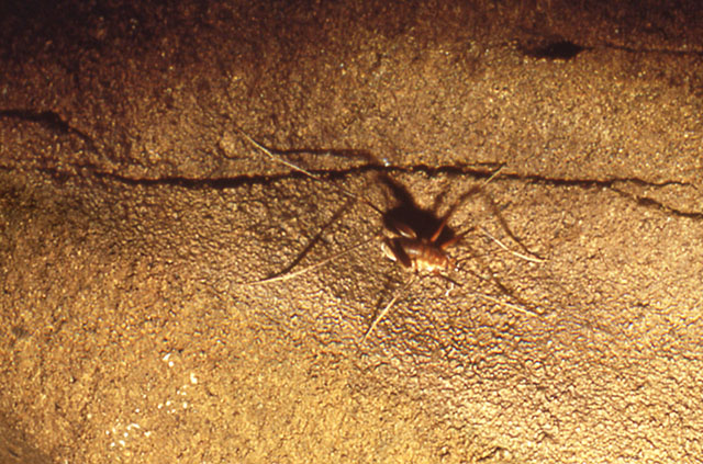
Image 3: Close-up of cave cricket on limestone ledge in Mammoth Cave. Here, a cave cricket sits on a limestone ledge in Mammoth Cave. (From tip of front leg to tip of back leg, the cricket is about 3 inches long.)
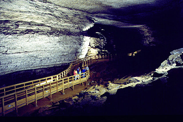
Image 4: Group of people on walkway at Broadway passageway in Mammoth cave, viewing rubble from a roof collapse. http://photo.itc.nps.gov/storage/images/maca/BROADWAY.JPG National Park Service Photo. Broadway of Mammoth Cave is one of the many huge passageways dissolved in the layered limestone of the park. Roof collapses happen occasionally, as shown by the rubble on the right, but are rare, so tourists are considered safe.
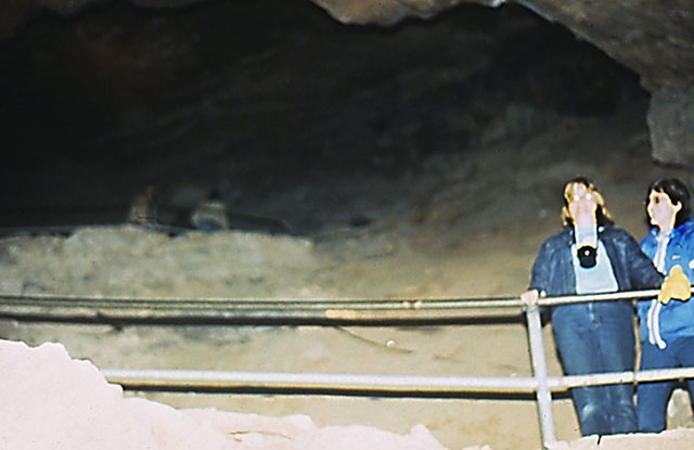
Image 5: Two people standing behind a railing in a room in Mammoth Cave. Cindy Alley (who prepared many of the graphics for the course) and friend Sue Croll in Mammoth Cave. The cave is immense; this room is several stories high.
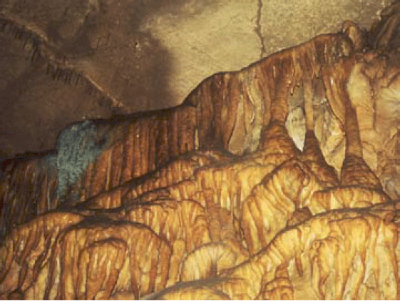
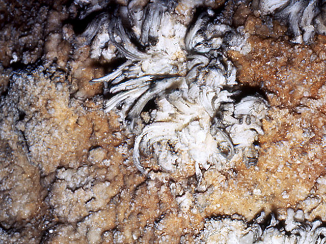
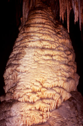
Image 6: Close-up of Gypsum flowers in Mammoth Cave. Gypsum flowers, Mammoth Cave (photo about 6 inches across). Limestone (calcium carbonate) often has a little gypsum (calcium sulfate), which makes formations with this distinctive appearance.
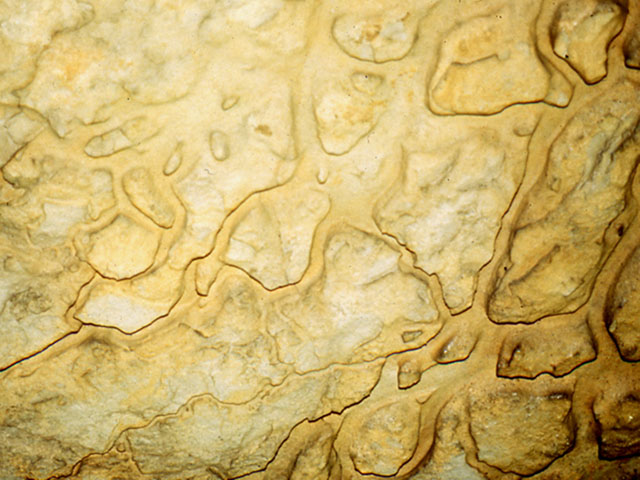
Image 7: Close-up of channels in limestone inside Mammoth Cave. Channels in limestone, Mammoth Cave (photo about 2 feet across), produced by dissolution of limestone in acidic groundwater.
Image 8: Tall narrow passage in Mammoth cave. Passage in Mammoth Cave. This probably started as a vertical crack, which was widened by dissolution of the limestone rock into acidic groundwaters flowing along the crack.
Image 9: Close up of Frozen Niagara section of Mammoth Cave. Frozen Niagara section of Mammoth Cave. More groundwater enters this region than in the rest of the cave, because the sandstone “lid” that covers much of the cave is broken here. The water picks up extra carbon dioxide in soil, dissolves limestone, then loses the extra carbon dioxide to the cave air (which exchanges rapidly enough with the outside to exhaust the carbon dioxide), and deposits the dissolved limestone as cave formations.
Image 10: Close-up of Frozen Niagara. Arrow points to line of hollow stalactites in upper left. Below stalactites is small patch of greenish algae. Water often enters along cracks; a line of hollow stalactites (“soda straws”) is arrowed in the upper left. The greenish color just below that line comes from algae growing where a Park Service light provides a little energy.
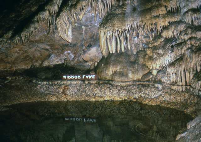
Image 11: Mirror Lake in Carlsbad Caverns. Mammoth is not alone among Park Service Caves. This is Carlsbad Caverns. Wind Cave, Jewel Cave, and others are equally beautiful.Image 12: Close-up of a roughly 20-foot-high cave formation in Carlsbad Caverns. The sandstone cap that prevents collapse of Mammoth and allows the cave’s immense length does reduce drip-water entry and thus cave formations, so other Park Service caves are often prettier than Mammoth. This roughly 20-foot-high feature is in Carlsbad Caverns.
Image 13: Upper image of limestone has arrows pointing at two snail fossils. Lower image has arrow pointing at one snail fossil. http://geology.er.usgs.gov/eespteam/smoky/ResearchAreas/smokys/cadesCove... USGS Photo Fossil snails (gastropods) in limestone, Cades Cove, Great Smoky Mountains National Park. Most caves and sinkholes are in limestone, and most limestone started out as shells or skeletons of marine creatures. Many shells are so broken as to be unrecognizable, but quite pretty fossils can be found.
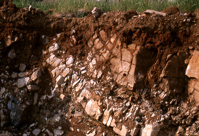
Image 14: Excavation area in State College, PA shows soil on limestone bedrock. Soil on limestone bedrock in excavation for a basement, State College, PA. The rock layers slope down to the lower right, and are curved a little. Dissolution has enlarged cracks and deepened some places more than others. When the deeper places become big enough, we say a sinkhole has formed.
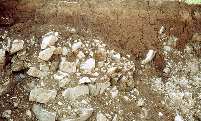
Image 15: Excavation area in State College, PA shows soil over limestone and formation of a small sinkhole. Another view of State College, PA soil over limestone, revealed in an excavation for a basement. A small sinkhole has formed to the right, where the redder soil dips down past the whiter stone.Image 16: Group of about 20 people standing by sinkhole, near Shenandoah National Park. http://va.water.usgs.gov/karst_img/karst_photo2.htm USGS Photo. Sinkhole near Shenandoah National Park. The center of the hole is just to the right of the right-most person. The ground slopes into the hole from all directions, so rainwater that runs in and does not evaporate must go downward through the bottom of the hole.
Image 17: Tree trunks and branches in a small sinkhole in Cades Cove, Great Smokey Mountains National Park. Sinkhole in limestone, Cades Cove, Great Smoky Mountains National Park. The sinkhole is the dip containing tree trunks in the foreground. Sinkholes most commonly form by dissolution of limestone along joint intersections, but cave-roof collapse also may form sinkholes. Here, tree trunks have fallen in, but in many places people have dumped things in, which go right to the groundwater.
Image 18: Sink holes in forest floor, covered with fall leaves, near Gregory’s Cave, Cades Cove, Great Smoky Mountains National Park. http://geology.er.usgs.gov/eespteam/<br></a>smoky/ResearchAreas/smokys/<... USGS photo Sinkholes in limestone near Gregory’s Cave, Cades Cove, Great Smoky Mountains National Park. Similar scenes are common along the Appalachians in many places. Soil, rocks, leaves, etc. fall into such holes, yet the holes are not full, indicating that materials are sinking toward the groundwater.
Word Document of Unit 6 V-trips
GeoMations and GeoClips
This week, we feature three GeoMations, and two GeoClips from the CAUSE trip out west, featuring Dr. Alley and Dr. Anandakrishnan in the Spring of 2004.
The three GeoMations could appropriately be called 1) How Deltas work, 2) How Dams work, and 3) How New Orleans Doesn't work, and in the video, you'll get to see Dr. Alley and Dr. Anandakrishnan "argue" over the Glen Canyon dam and its effect on Lake Powell above the dam and the Colorado River below.
As before, we hope you enjoy these, and find them to be useful complements to the readings, class notes, and slide shows of Unit 6.
GeoMations:
How Deltas Work
We're flying along in our helicopter out over the ocean, and we're looking towards shore at a beautiful beach we just saw there. And we're seeing the pretty waves of the ocean underneath us. And we see a great river coming down to the shore, something like this, meandering along the way some of these great rivers do.
Now if we could somehow hang along in our helicopter and wait for a flood, what we'd notice is that sitting next to the river, there's a bunch of trees that are growing. And when the flood happens, the water would start trucking out of the river into both directions. And as the water came trucking out of the river, it would slow down when it got into the trees.
And as it did so, it would start depositing a layer of mud. And that layer of mud would be thickest very close to the river, and then it would thin on out across the flood plain of the river. And this would be happening on both sides of the river. And so after a while, we would see that the river is contributing to building a natural levee that sits along the river and runs all the way out to the mouth.
Now, if we could keep watching this happen over very long times, over hundreds or thousands of years, we would see that in many places, the ocean is not strong enough to get rid of all the mud that the river delivers. And so the river would start building out into the ocean, and it would just extend its way out there, building a levee. And as it did so-- not a very high one-- but as it did so, the river itself would lengthen. And so it would be coming out in there, and the water would be flowing down to the sea.
And when this is going on, it has to keep going downhill. So it builds up, as we saw earlier, as well as building out. And so you start getting higher walls that hold the river in, on up here, to allow it to flow downhill and run out like that.
And so as the bed of the river is raised, and it gets higher walls, it's like being on the log flume at the amusement park. And at some point, there's a flood, and that wall breaks, and the river takes the short way down to the sea. And then the whole process will start over again. It'll start building a new wall, and building out that way. And eventually, sometime in the future, this one will become big, and then it will do it over again. And so rivers build deltas. They switch from one place to the other as they build out.
How Dams Work
So let's take a look, a strange look, at a river. This is going along the river towards the sea. And this river happens to have trees that grow up on the riverbank. So you can get an idea how we're looking at this.
And what we want to do is ask what happens when we build a dam on this river? And we're concerned about the future of a couple of houses that used to be along the river, one just below the dam right down here, and the other one up above the dam up here, sitting along the riverbank. Well, they build the dam, and the dam fills with water, and it doesn't quite take out the house up above.
But the river's carrying mud. It's carrying sediment. And the sediment starts to deposit out into the lake to fill it with a delta.
Now, rivers have to go downhill. So as the lake is replaced with the mud, if the river were to hit a perfectly flat spot like this, you know what it has to do. It has to build up so that it's headed downhill. And so as the river builds the delta out into the lake to fill the lake, why, you have to bury the house, and that makes the person who lives there mad.
Now, at the other side, it's even more interesting. There's no floods anymore, so the river loses the ability to carry gimongous rocks, which might make the homeowner happy. But the water coming out from the dam is clean. It has no sediment in it. And if there's sand below the dam, why, the water will start washing that sand away.
And that will do a number of things. Your house, now, rather than sitting there right next to the riverbank-- you'll look out some morning and you're ready to fall into a giant hole that's been cut. And you get out there and you fall and then you say, oh, no, and you're very unhappy.
You are not nearly as unhappy as the salmon that are trying to come upstream, because as you may know, salmon like to get really amorous around sand and gravel bars. And if the river has washed away the sand, then you can't have fun with your honey and then leave your eggs there to do well. And so you have a big loss in salmon, as well as getting people's houses unhappy. And so putting a dam on a river makes a big difference.
How New Orleans Doesn't Work
Here's a great tree. And the great tree is standing up on a bluff looking down on the Mississippi River, which sits down in a valley. And the river has a little natural levee-- this, we haven't gotten to human built ones yet-- and it sits down in a valley.
And then, over on the other side, there's another natural levee, and then you go up another bluff to the top. And the river itself sits down in its river valley like this. And it is flowing towards you, which is what the head of this arrow shows.
And the river is sitting on a few miles thickness of mud that have accumulated over the years as the delta has built out into the Gulf of Mexico. And whenever you get a few miles of mud, everything is sinking under its own weight. And that, in turn, means that the surface is sinking, as well.
Now, nature has a way of handling this surface sinking problem, which is that during a big flood, the water spreads out over the flood plain. And mud falls out of the water, and the mud makes a new layer. And so as the surface sinks, more mud is added. And so there's no net change in the elevation. And that's just fine, except for one little problem.
Over here you have a city. And you've built this big city. And you really don't want that flood coming into your city. So you just call up the Corps of Engineers and you say, make a big wall, and make sure that that flood is not going to get into my city.
Well that's just fine, except that doesn't stop the sinking, because the thing is going down. And so if you come back later, what you'll find is that the surface has moved down to a place like this, and your city has moved down to a place like this. I'm using a darker line so you can see where it's gone to from where it was.
And so you tell them to make the wall bigger. But meanwhile, the city is sinking even deeper. And you've gotten up somewhere way down here, now.
And things are getting really nasty, because at this point, there's a really big storm. And it manages to get just over the top, and it fills your city with water. And then you're underwater and you're very, very unhappy. And this happened to New Orleans. And the sinking is not stoppable, so if it's rebuilt, it is likely that it will happen again.
GeoClips:
Dams cause huge changes on rivers, both upstream and downstream. In this film clip, Drs. Anandakrishnan and Alley discuss the Glen Canyon Dam and Lake Powell on the Colorado River. Huge changes were caused by this project, including in the Grand Canyon far downstream. The CAUSE 2004 class used some clever editing to manufacture a disagreement between the professors, who are much closer to being on the same wavelength than you might imagine by watching this.
DamIt!
Today we're going to go see one of the most extraordinary manifestations of man's desire to tame the wilderness.
We're looking, standing here above what was once a vast and deep and beautiful canyon and has turned into a wonderfully used lake that people like to go boating on and people like go swimming in. And so we've seen a great change in what happened here from a world that was used by very few who love solitude to a world that's used by many who love running around in motor boats.
Well, I think a lot of the early settlers really wanted to place their mark. They said, we are not going to be defeated by this land that has only a few inches of rain per year. We will live here. And the way to do it is to get lots of money from Washington that we collect out East and bring it out West here and build these dams. And these places just do not belong. They are magnificent creations. They are incredible engineering masterpieces. But they should not be here.
And so it obviously does a tremendous amount of good, and it's very clean. Once you have a dam, once the lake gets here, you don't dirty anything up. You're not running out smoke from your smokestack that will dim the air in the Grand Canyon.
They should not be here. And I think we've learned that over and over again. But you go to India, you go to China, and they're doing the exact same thing. The Three Gorges Dam in China, one of the most enormous, incredible engineering projects, displaced millions of people, is an absolute ecologic disaster.
If you've got hungry people, and you can save that water and ship it to them, it's food. If you've got people who need power to do things, and you can ship them the power then they can use it.
Dams are amazing human achievements, but they have incredible costs associated with them. So to me, it's very much of a bittersweet kind of a thing. As a former engineer myself, I can appreciate the artistry and the mastery that goes into building these. But as a practicing geologist, as a practicing resident of this planet, I find them a little depressing to be quite honest.
We're going to argue this one again on a lot of rivers in a lot of places for a lot of time.
Human actions are more and more affecting the amount and quality of water and the ground, with effects that bounce back on us and on other living things. Here, Dr. Alley chats about groundwater issues of great concern to the National Park Service at the Grand Canyon.
Canyon Groundwater / Grand Canyon National Park
So now we're on the rim of the canyon. The rim of the canyon does not have streams on the surface. When it rains, which is not all that often, but when it rains, what happens is that the water soaks in. So if you had a rainstorm, you see the water start to make a stream, but then it soaks in. What happens to that water? It goes down through the spaces in the rocks until it hits a rock that it can't get through, such as the Bright Angel Shale. Then it runs along laterally and it comes out at those beautiful springs that we see in the canyon.
Now what's happening here is there's more and more people want to live here, and they want to have water, so they drill wells. And after you drill a well, you suck the water out and you use it to water your grass, or your crops, or your golf course, or to drink or flush or what have you, and eventually it evaporates. And so what you're doing is removing the water that should be running to the springs. And there's worry-- it's not happening yet, but there is worry-- that someday, we may start to lose the springs in the Grand Canyon and the unique biota, the wonderful ecosystems, that live down there because of development outside of the park up here.
Want to see more?
Here are some optional resources you might also want to explore! (No, these won't be on the quiz!)
Join Dr. Alley to learn about formation of Fossil Fuels, in Barataria Reserve, Jean Lafitte National Historical Park and Preserve, Louisiana, from the PBS television special Earth: The Operators’ Manual.
Deltas and Plumes
(An extensive collection of animations on this subject)
River Systems: Process and Form
(An extensive collection of animations on this subject)
Processes of River Erosion, Transport, and Deposition
(An extensive collection of animations on this subject)
Video Lecture
The Unit 6 lecture features Dr. Sridhar Anandakrishnan and is 1 hour and 4 minutes long.
Good morning. Welcome to G-SCI 10, Geology of the National Parks. We're going to be looking this time at tearing down mountains some more. Last time, we broke them apart using freeze-thaw action, and by chemical action, and made soils. This time we're going to talk a little bit more about the transport of them-- streams and rivers.
My name is Sridhar Anandankrishan, and I'll be your guide through some of the lovely places. And we're going to take a little bit of a detour to look at some of the damage that water can do. So, let's take a quick look at some lovely pictures and then we'll start on the section.
Redwood National Park on the coast of California. You can go fly into San Francisco and drive up the coast from there. And it's just magnificent trees. These trees, there's a famous one that they cut a hole in it and you can actually drive a car through it. These trees are monsters. They're as big around as a small house. And they tower up in the sky. And you can imagine you need a lot of water to keep a critter like that alive, and you do.
Just go over the mountain. Not very far. Maybe a couple hundred miles. Head inland from Redwood and it's dry as a bone. It's Death Valley National Park. Hottest, driest, lowest place on the planet. Why is it that these two places just very close together, a couple hundred miles apart. Redwood National Park over here with these gorgeous, enormous, towering Redwoods that suck up all this water, this huge root system that needs lots of water to keep it alive, cool climate, rainy climate. 200 miles to the east, you go over the mountain, and you're at Death Valley National Park, it's dry as a bone. What's going on? So that's the first thing we're going to look at.
Let's take a look at some pictures over here. Sequoia sempervirens, the ever-living Sequoia. They live for a long time-- couple thousand years, and then they'll fall over-- kawoomph. And then the new trees will sprout from the trunk. And so when you go there you'll see these lines of trees. They weren't planted that way. It's just that when an old tree falls down, a new one comes up from the trunk, and so they'll be a whole line of them where the old one had fallen down. It's quite an extraordinary sight.
All these ferns and rhododendrons, all of that, surrounding the base of them. The Redwood needles help produce these very acid soils that the rhododendrons really like around here. We have that as well up on the tops of the mountains, these beautiful rhododendron forests. They can tower way up, 200, 300, almost 400 feet up into the sky. They are the world's tallest trees. They are the world's most massive organism. The heaviest single living thing.
The Redwood Coast is rainy and foggy. These trees couldn't make it otherwise. And you go inland a little ways and at the same latitude, you've got this amazingly dry landscape. This is a picture pulled straight out of our very first section a long, long time ago on Death Valley National Park.
Now we're going to look at the surface. Before, we were looking at Death Valley to understand something about pull-apart zones, about spreading, all these other tectonic forces. This time, we're going to look at the surface. Why is it dry at the surface?
Here's a map. The Pacific Ocean is to the bottom, North is to the left on this map, not at the top as it normally is. And you can see this coastal Redwood range all up and down the coast. And then, inland you have Death Valley. And, in between, you have the Sierra Nevada mountains, and that's the key. You have these tall mountains in between, and they intervene and somehow prevent the water from getting from the coast inland to Death Valley. So, let's take a look at that.
The first thing we're going to do is look at winds, and I'll come back to this map in a second. Let's go to the drawing tablet here, and we'll take a look at why the Redwood Coast is wet and cool, and the Death Valley is dry and hot.
We're talking about wind and water this time. We have the Pacific Ocean. We have the Sierra Nevada mountain range. And we have, on the left, these towering Redwoods. And on the east, we have Death Valley. Hot, dry, cool, wet. What's going on? Why is the case?
When the winds blow in from the Pacific, they carry water. Water evaporates in the Pacific Ocean, it blows on shore onto land in California, and it hits the Sierra Nevada mountain range. So, these winds have lots of water in them. The winds are heavily laden with water. They blow in from the ocean, they blow onto the coast, they start heading inland, and they hit the Sierra Nevada ranges.
When they do that they have to start climbing up the mountainside to get over. They can't just tunnel right through the Sierras, and there aren't enough passes for all of that air to go through these low passes. So, the winds as they come along have to rise up the mountain, have to go up to get down on the other side.
As they do that, as the air rises, it cools off. So, as this air rises up to the top of the mountain, it cools off. Cool air can hold less water. You just can't have as much water in the air as that air starts to cool off. What's the result? Rain. As that air is climbing up the side of the mountain, it's cooling off, it can't hold all that water. That water's got to go somewhere, and it falls out as rain. And so, you have all of this rainfall on the windward side of the mountain.
And by the time the air gets to the top of the mountain, all of the water has been squeezed out of it. You take that air, you cool it off, cool it off, cool it off as it rises up, and as it cools off, the water rains out of it, rains out of it, rains out of it. It gets to the top, it's cold and it's dry. It doesn't have any water left in it. It gets to the top, starts to sink, but it is dry. There's no more water left in it. No rainfall.
So, you get no rainfall on the backside of these mountains or what's known as the leeward side of these mountains because all of that water has fallen out on the windward side. This is the rain shadow effect. And this explains why it's so dry in Death Valley. Very simple process. It's you've got this nice, wet air coming in from the Pacific, but all that water gets dumped on the windward side of the mountain, and you end up with it being really dry on the leeward side or on the rain shadow side. That still doesn't explain why it's so hot over there in Death Valley, and that's the next thing we'll look at.
Same picture. Pacific. Sierra Nevadas. Redwoods. Sequoias. Here's that same picture. You've got air coming in off the Pacific, it's heading up the slope of the Sierra Nevadas, its cooling off. We talked about how all the water gets squeezed out. It's dry when it gets to the top of the mountain. And now it's sinking down the other side, and as it sinks it'll just heat up naturally. As you get to lower and lower elevations it gets warmer and warmer-- you know that. When you're at the base of the mountain, it's warm. As you go on a hike and you start climbing up the side of this mountain, it'll start to get cooler and cooler and cooler. Until finally you get to the top, and you've got put on your jacket.
Same process as you go down. As you head down the slope of the mountain, you start shedding your jacket, and then your sweater, and then you're in shorts and tee shirt by the time you get to the bottom of the mountain. So, this very natural process. It just gets cooler as you rise, and warmer as you drop. The one difference, though, is that the cooling off as you go up the hill is about three degrees Fahrenheit for every 1,000 feet that you rise up.
So, if you were to take a thermometer and go for a hike and go up Mount Nittany, and as you head up there, you would find that if you climb 1,000 feet, the temperature has dropped about three degrees Fahrenheit if the air is moist. If you have really wet air, if you have really moist air, lots of water in the air, very humid day, and you start to walk up, it'll cool off about three degrees Fahrenheit per 1,000 feet of rise.
On the other hand, as you head down on the rain shadow side, the leeward side, the Death Valley side, the air is heating up. Same way it was cooling off as you went up, now it's heating up. But now it heats up by five degrees for every 1,000 feet of drop. So, every time on the rain shadow side you have 1,000 feet of loss of elevation, the temperature's now gone up by five degrees. And you walk down another 1,000 feet, the temperature's gone up another five degrees if the air is really dry.
So now, we have this very dry air on the rain shadow side and it's heating up faster. And so, you drop down the same distance that you climbed up on the other side of the mountain, and you've heated up way more than you cooled off. And that's all the difference. When you take a packet of air and you raise it up to the top of the mountain, and then you remove all the water from it in that process, and then you bring it down on the other side, you've heated up way, way more than when you started out.
And so, this is why Death Valley is hot. You start out cool on the coast, you end up hot inland. There's an animation online, and you can take a look at that and review that again. Let's go back to the PowerPoint.
Where do these winds come from? We kept talking about these winds blowing in from the Pacific Coast. Why do you have winds coming in from the Pacific Coast? It's a fairly straightforward system. The sun heats the Earth, and hot air rises. That's the starting point for this whole process.
If you took one thing away from the first third of this class, it was the heat deep inside the Earth drives these convection cells, drives all of the mountain building. Take one thing away from this section, it's that the heat of the sun pounds down on the Earth, heats up the air, and that's what makes the winds, and then the winds do everything else. So let's take a look at that process.
Here we have a map of the Earth showing the places where you have these convection cells in the atmosphere. We're not talking about convection in the Earth anymore, but now convection in the atmosphere in very much the same way. You heat up the air, it rises up, cools off, and there's more heated air that's coming up from underneath it. And so this cooled off air gets shoved off to the side.
Let's take a look at this. We're going to go back to the drawing tablet. This is just so much better diagram, so you can keep this map in your head as I'm drawing my very crude pictures, that would be helpful, and then we'll come back to this.
Air circulation is driven by temperature, by heat-- same as convection in the Earth was. But the heat of the sun drives air movement. The equator is warm. The pole is cold. And the reason for that-- this is the Earth, this is the equator, and this is the North Pole where Santa has his workshop. The Earth is spinning around and around. And the Sun is somewhere way over here sending sunlight to the Earth.
If I were to go and look at a chunk, a square of sunlight, as it flies from the Sun to the Earth, I would find that it would smack straight into the equator, head on. The square, I just took a square piece of sunlight from the Sun and I carried it to the equator, and it went straight over there, and it ran straight into the equator.
If I did the same thing at the pole, I took a square of sunlight and ran it towards the pole, I would find that it would be spread out over a huge chunk of the pole. It would be a small part of the equator. All of that Sun is beating right into that small part of the equator because it's head on. But at the pole, that same chunk of sunlight is smeared across a huge chunk of it simply because of the curvature of the Earth. The Earth is curved in such a way that when the sunlight hits it, it hits the equator head on, but it smears across the pole, and so the poles get colder. They get less sunlight.
It's as if you were to take a piece of toast and take a spoonful of peanut butter and spread it across that. Or if you were to take that same spoonful of peanut butter and try and spread it across a huge sheet of plywood, you wouldn't want to eat that plywood. But there wouldn't be very much peanut butter on that sheet of plywood because you've taken the same spoonful of peanut butter and tried to smear right across this huge sheet of area, and there's very little peanut butter on any given spot.
Same thing happens on the Earth. The Sun is beating down on the equator head on, and so, all of the Sun's energy is concentrated in a relatively small area. It's nice and hot. Up at the pole, the same amount of energy's spread across this huge area, so every spot is cold and shivering. That's why the poles are cold and why the equator is warm.
What happens? We'll go back to the Earth, we'll make it bigger now, we have the equator, and we have this heat along the equator. The equator's being heated up because the sun is beating down straight on it. All of the energy is being jammed into a relatively small area.
The air gets warm. And what happens when things get warm? You know that. We've seen it over and over again. When things get warm, air gets less dense. What happens when things get less dense? We've seen that over and over again. Rises. Air rises up, hot air rises. And so all around the equator you have hot air rising upwards into the atmosphere.
As it rises up, somewhere up here, it will cool off. As it rises up it will cool off, but there's more hot air coming up from below.
And so, this cool air can't just sink straight down. This cool air gets shoved off to the side. And eventually it sinks down. When it gets to the bottom, it's heated up again. As it sinks down, it gets hotter and hotter and hotter. And then, it returns to the equator, and the whole cycle begins again. It heats up, goes back to the equator, rises back up, and you have a convection cell.
This whole process is a convection cell in the atmosphere. And this is wind. It's movement of air over the surface. What's that? That's wind. So, this wind is driven by rising air in the equator. It goes up, cools off, sinks back down, and then blows back to the equator. Rises up, goes out, sinks back down, blows back to the equator. In the process of blowing back to the equator, that's wind. Air transport by that.
Let's go back to the map that I showed you on the PowerPoint because that illustrates it so much better than this rather crude diagram. But I hope you get the idea from this.
You're seeing the same thing here, but just more fancily drawn out. This is an image from the USGS. Rising warm, moist air produces what, in this diagram is called a Hadley cell. It's just a convection cell. It was discovered by a scientist named Hadley, so they called it a Hadley cell. Rising warm, moist air. Descending cool, dry air, it gets cooled off, it falls down, and then it rotates back around, blows through the mid-latitudes back to the equator.
And so you have what are called the trade winds. They were called the trade winds because they blew so steadily that sailing ships could use them for trading purposes. They always knew these winds would be there when you needed them, and you could count on them. And so, you could fill up your ship with whatever you wanted, and your sailing ship with these big sails would catch the trade winds, and would be blown from Europe to the new world without any trouble at all. That's why they were called the trade winds.
The North Pole is cold, and you have these secondary Hadley cells, or secondary convection cells, called the Ferrel cell and the polar cell. But really, the idea is the same.
This is a map of the world's deserts. And if you look at them, what you see is you have these deserts at a few degrees north and south of the equator where that convection cell brings that air down again. The air goes up and then it comes down. Where it comes down, you get these deserts. Why? Because there's no moisture in that descending air. All of it is gone. So, rising moist air. You have all this rainfall at the equator because all of that air is rising up, and the rain's all falling out of it.
As it gets colder and colder and colder, the rain's just falling out of it. It goes up there, it goes over, and it comes down in the Sahara. It comes down in Australia. And there's no water left in it. It's all gone.
And so, you get these huge deserts, the Saharan Desert, the great Sonoran and Chihuahuan deserts in the US and Mexico. You get the great Australian deserts, and the Kalahari, and the Namibian deserts in Australia and Africa. It's because of these convection cells.
So now, we've talked about wind, and we've talked about a rain shadows. Now, let's take a look at what happens with that water when it falls out of the air and it makes rivers. You get rain, you get rivers. Let's take a look at those.
Water falls from the sky. It's called rain. Very straightforward. What happens to it when it gets down is far more complicated. About two thirds of it goes straight back up into the air. It mostly is taken up by plants and trees through their root systems.
So, here in State College we get about 40 inches of rain. That's about something like that. Every year. Some of it comes as snow, some of it comes as rain. If I were being pedantic, I'd say we get 40 inches of precipitation, but think of as rain. Two thirds of it, about that much of it goes straight back up into the air. The plants drink it, it goes straight up. The trees drink it, it goes up through their roots, goes out through their leaves, straight up into the air again. Or it just falls down and just collects in puddles and then the Sun comes out and those puddles evaporate and it goes straight up into the air again.
About a third of it, about this much, either sinks down into the Earth and turns into groundwater, or it runs off across a surface, falls into Spring Creek, falls into some other creek, eventually makes its way to the Juniata, the Susquehanna, and then down to Delaware Bay, and then out to the ocean, or to Chesapeake Bay and out to the ocean.
So, about a third of it, about that much actually remains on the surface of the Earth, two thirds of it goes straight back up again. This is known as the hydrologic cycle. Fancy name. All it means is you get evaporation in the ocean, it blows onto land, it rains out because of the processes that we talked about, rains out of it because it cools off as it goes up a mountainside. It can't hold all that water, and you get rainfall. Some of it goes straight back up again, and then maybe rains out again and it goes straight back up again and rains again. And some of it gets trapped in the Earth as groundwater, and some of it flows into streams and rivers and goes to the ocean.
Water is unique to Earth, we think. Everybody's always looking for water in all the outer planets. They go to Mars, they want to look for water. They go to the moons of Jupiter, they want to look for water. They go to the Moon and they want to look for water. It's so cold on the Moon, the water probably is almost certainly in the form of ice.
The key is life needs water. If you're going to have critters, if you're going to have any kind of organisms alive, we think they've got to have water. Water is so important to everything, for life to exist, that people don't look for living organisms on Mars, they just look for water. And they say if we find water, I'll bet you there'll be some critters alive there. And that's probably the case. Anywhere on this planet you go and you look for life, you look in the places where the water is and you'll find something alive there.
The human population of this planet is exploding. We're up to six billion or so, and we're heading towards 10 billion in the next 100 years. We all need water. And all the great wars that will come, a lot of the wars that are going on now are probably, to some extent, about water. People need water, and they'll fight each other for it. So, we need to be careful about watching what we do with it.
Here is Johnstown. Here is Johnstown. The great Johnstown flood. It came through, and it smashed in and destroyed-- there was a dam up river from Johnstown. It was a private dam that collapsed, and all the water behind it took Main Street here, nice, lovely place, some horses going down it, and all of these trees, enormous trees, rammed into the second story of this building. So, water is not a benign material. It can be quite destructive.
It's now the summer of 2006 when I'm filming this material, and just recently, just a few weeks ago, Wilkes-Barre, Scranton, the whole Northeast of Pennsylvania, Elmira, Binghamton were all flooded. These enormous rains came down and flooded out all of those rivers and they rose up over the levees. Luckily, the levees held and so people weren't killed, or not that many people were killed, but it was still quite disastrous.
These streams, when they make their way down, they modify the landscape. They dig holes, basically. Streams are very good at eroding their bed. Streams carry water. Duh. We all know that. But streams also carry sediments. Sediments are simply small pieces of rock, or sometimes bigger pieces of rock. And in the case of streams in the mountains, really big pieces of rock. So, sediments are simply pieces of rocks, and streams and rivers carry that along with the water. And they're really good at washing it away.
And so, all those processes that we talked about last time, mass wasting, a freeze-thaw breaking up all these rocks, you put a stream in there, and it'll just take that material and move it away. And then, these freeze-thaw actions and mass wasting actions will bring more material down to the river valley, and the river will wash that out. And then, more material will come down and that will get washed out.
And you do that for long enough and that mountain is gone. It takes a long time, but eventually it'll be gone. Without the river, you wouldn't have been able to wash all that material out, and so the valley would have filled up, and the mountain would still be there. With the river, you just wash the stuff out, more comes in.
Floods do most of the work. The normal flow of the river just isn't powerful enough to move much. The normal flow of the river will carry a little bit of sediment, but it certainly won't move big boulders. It certainly won't break things up. But then, every so often, just about every year usually, you get these floods, and every 10 years you get big floods, and every 100 years you get these enormous floods, and they're the ones that do the work. They're the ones that move enormous masses of material downstream. We use it. We need it. We've got to have it. We need it for agriculture, we need it for industry, we need it for moving material up and down the rivers, we need it for making hydroelectric power.
So, water is enormously important, and controlling streams has been probably one of the primary industrial motives or the things that we do most of all down through human history. If you look at human settlements, they were always on the banks of rivers because you can get water out of them to water your crops. You can use them to run mills to mill your grain. You can build boats and you can go up and down and trade with your friends up and down the river. So, all human settlements have always been associated with rivers.
Here is Glen Canyon Dam in Arizona. And the river is on the lower part there, the Colorado River is flowing down. And if you were to simply imagine that lower picture, that narrow deep gorge heading up, that's what it would have looked like 100 years ago. But back in the '30s and '40s, that dam was built, and when that dam was built, the flow of the river couldn't get past that dam. It got caught over there. And now, that lake that's above the dam is very useful. People use it for recreational purposes. But they also use that dam for hydroelectric, they generate electricity. That dam is used for irrigating crops all through that area.
So, the hydrologic cycle, as I said before, as water evaporates from the ocean it rains onto the land, and some of it goes into streams, some of it goes into groundwater, but most of it goes straight back up into the atmosphere. Let's follow one of those streams to the ocean, and let's take a look at what happens with it.
Streams are driven by gravity. Just like everything else, water wants to head downhill. And water can head downhill a lot more effectively than rock can. Because you get the soil or this rock up on a hill slope, and it can be nicely cemented in place. It can be happy where it is, especially if it's got lots of trees and grass that's stabilizing the slope. That slope can be fairly stable. You get rain, the rain falls on it, that water's going to head downhill. There's nothing that can hold water back, except things like dams.
Streams are recharged by direct rainfall, and by groundwater springs. So, rain can fall straight into the stream, or onto the banks of the stream and flow into the stream. Or the water can fall on the land far, far away, sink down into the Earth, and then slowly make its way through the earth as groundwater, and then these springs will come out and recharge the streams. And that's why rivers run even after long periods without rain.
Streams carry sediment, and mass wasting delivers sediment to the rivers, and then the rivers carry that sediment out usually in these big floods, but also during the normal processes. When those streams get down to the flat areas where the stream is falling more slowly, than that sediment gets deposited. So, up here in the mountains, mass wasting is bringing material into the stream, the streams are flowing through these very steep valleys, and so they carry lots and lots of water, lots and lots of sediment. And then, they flow out onto the plain out in front of the mountain. The streams slow down because they're going in more shallow slopes. As they slow down, the sediments can't be carried by these streams anymore, and they deposit them.
This is how a stream carries sediment. This is a cross section through a stream. The surface of the stream is at the bottom. And the top of it is where the stream is flowing most rapidly, and the bottom of the stream is where it's flowing less rapidly. And it can slowly move material either by what's known as suspended load, which are really tiny particles that are just floating up in the stream. And if you look at a stream and you see it's brown, it's because it's got all of this junk in it.
Water's blue, you know that. And normally a stream, if it's flowing slowly, is blue. But after a big storm, after it's churning and it's carried all this junk into it, all the sediment into it, it's flowing fast. You look at it, it'll be brown. And why? It's because of the suspended load. All of this dirt basically that's suspended in it-- soil that's suspended in it.
Down at the bottom of the stream, you have what's called bed load. This is the material that bounces along the bottom. The water isn't flowing quite so fast at the bottom, and so it can't carry all this material right up in it, and so it just picks it up and drops it, picks it up and drops it, picks it up and drops it, and stuff bounces along the bottom of the stream bed.
And then, you have bigger boulders, or gravel sized pieces of rock that are down at the bottom, and those usually don't move that much until you get one of those big floods. And then, all those pieces along the bottom will be washed along and moved downstream. Suspended load is the fine stuff, bed load is the bigger stuff that bounce along the bottom breaking up the rocks as they go making smaller rocks. So, this is another way that you have mechanical disintegration. These pieces down at the bottom, you have these rocks bouncing along, and every so often one will hit another rock and break it open. Or it'll just simply scrape off the bottom of the river and break off small pieces that will then be carried away with the river.
Two types of streams. Meandering streams-- this is a classic picture that you have, and we'll see some pictures here where the stream goes around one way and then comes back. Streams never go straight, they always have these big curves to them. If a river has mostly fine sediments, it'll make a deep channel, it will get clogged, and it will just meander. It will stay in its channel for the most part. It will keep breaking out or eroding along the outside of one of these curves and depositing on the inside of one of these curves. And so, the curves will get bigger and bigger, and we'll see a picture of that in a second. And then, it will make another curve and another curve. And here's a photograph of that.
So, you've got the stream that's coming down, and when it goes to the outside of the curve, it will have to speed up to make that curve. And then, it will keep eroding against what's known as a cut bank. And then, on the inner part is where the water's flowing more slowly and it will deposit material there. And so, the river over time will keep migrating inwards.
Eventually, eventually, that neck could get pinched off completely, and that ox bow will be cut off, and you get these ox bow lakes where the river has been cut off from its upper curve and now the river is just going straight. It used to meander around that curve, but over time it just cut across that curve and went straight. And that stranded piece of the curve is called an ox bow lake. It's named after these big yokes that the farmers used to put around oxen, and then that yoke would be hitched up to a cart, and then these oxen would plod along dragging the cart behind them.
A braided stream is a second kind. This is where you have lots and lots of channels that are all intermingled, and you don't know which is the main channel. They all are carrying a little bit. And what happens is you have all these big chunks of rock. They fall into the river and they block a channel, and so the river picks a different one. And then a big chunk of rock falls into that one, it gets blocked, and the river picks a different one.
So, you need big chunks of rock. Where you find big chunks of rock? In the mountains. So, it's mainly in the mountains that you have these braided streams, and it looks like a braid of hair from above, which is where the name comes from. And here's a photograph. You have all of these different channels that you don't know which one is the main one. And we'll go to another picture here. Mainly in mountainous areas where there's lots of big boulders. And one of these channels could get blocked very easily, and the river will pick a different way to go.
Another way to stop the flow of river is to put up a dam. Beavers build dams, natural landslides can create dams, or you can go out with a bulldozer and a great pile of concrete and you can simply stop the river. And that will stop the water temporarily until you get a lake built up. But, eventually, the lake will rise to the height of the dam, and then the water will start to flow again. The engineers will open the valves and the water will flow, but you'll still have a lake behind the dam.
So, the water stoppage is temporary, the sediments get stopped forever. Engineers don't like to have sediments going through their machinery, it clogs them up. And so, they pull water from the upper part of the dam. And all these sediments that we've been talking about, they come down with the river, they don't make it past the dam. They get deposited behind the dam, more sediments come along, deposited, more sediments come along and get deposited. The water keeps going through, but eventually the sediments are going to fill up that dam.
Here's a picture showing that. You have a dam, and over time, the water is filling up behind it, but along with the sediments are filling up. And that deposition is going to slowly, over time, completely fill up that lake, and then you're left with a useless dam, and you're going to have to build another one. And it's happening to many dams around the world. Dams have been-- some of these big dams have been in place for 100 years or more, or 50 to 100 years, and they're starting to fill up. People go out there, they dredge them. They have big machines that try and suck up these sediments. But in the end, these dams are going to fill up.
The river below the dam is clean of sediments. All the sediments have been dumped into the lake above the dam. And so, the river below the dam doesn't have any of those sediments left. Lots of water-- remember, the water's going right through. But that water that's coming out is clean. It doesn't have any sediments in it. What's it going to do? It's going to pick up sediments.
And so, you get extra erosion below the dam that you didn't used to have before. Before the dam was built, the river would come down, sure, there was lots of water coming, but there was also sediment coming. And so, if there was any erosion, there would also be deposition. And then, that was that most of those places would continue to have these gravel and sand bars. You build a dam, all the sediment's up there. You get this clean water rushing out past the dam, and it will enhance the erosion.
So, let's go to the drawing tablet and take a look at that process. This is a cross section of a slope, of a hill slope. Then you have a river that's happily slowing down. So, this is water that is flowing down. And remember, in addition to that, it has sediment that's caught up, and that's being transported down along with the river.
This is the case before I come along and I build a dam. It's a big old concrete wall. As soon as I do that, I put a lake here. What I've also done is I've done away with all the sediments downstream of that dam. All these sediments still coming down, all those red particles still coming down, but they're now filling up the lake upstream of the dam.
Downstream of the dam, I have just this lovely clean, blue water rushing along, and what's it going to do? It's going to start picking up sediment from the riverbed that it would not have picked up before. Before, it had all these sediments it was already carrying. It couldn't carry any more sediments. And so, it left the riverbed alone. But now, it's bright, blue, clean water, no sediments in it, it has lots of ability to carry sediments, and so it does.
Over time, you will erode downwards. Erode below the dam. This would not have happened until you put the dam in. So, you get deposition above the dam, and erosion below the dam.
Back to the slides. These gravel and sand bars below the dam get washed away. Lot of critters live on those bars. They don't have a place to live anymore. All of the beautiful, blue, clean water that's rushing out, now there's all these fish that used to like having this warm, dirty water-- dirty because it had soil in it to live in, and now they're living in this bright, blue, clean water, and they don't know what to do anymore.
They've evolved to hide in this from their predators, and they can't do that anymore. So, there's a lot of fish that go extinct because of that. Eventually, the reservoir above the dam will fill up and you need to build a new one anyway.
Let's follow that river past the damn, past the mountains, out on to the Gulf Coast. So, this river has just flowed from the mountain down onto the plains, and across the plains to the ocean into New Orleans. And we're going to talk about Hurricane Katrina. There are all these levees protecting New Orleans. Why does New Orleans need levees? It does. We'll find out why.
And one of those levees broke, the 17th Street levee, and all this water came rushing into New Orleans because New Orleans is below sea level. Why is New Orleans below sea level? We'll find out. It's below sea level, the levee broke that was protecting the city, and the water rushed in, and you know the disastrous consequences of that.
So, what's happened? Every year, snow melt comes along, extra rains come along in the spring, the rivers can't carry all of this. The rivers come along, and the water goes over the bank and on to the land on either side of the river and it floods. It happens. It happens every year. And it carries water and it carries sediment out onto the fields on either side of the river, and it deposits it there. Why? The river's rushing along, carrying sediment, it floods out onto the sides, the water spreads out, slows down, sediments can't be carried if the water's moving slowly.
Sediments will slowly sink down and be deposited onto the field. The farmers love it. The Nile Delta famously, pyramids, the Sphinx. All that civilization 3,000 years ago depended on the Nile flooding every year bringing this lovely sediment up into the farmer's field and depositing it, and then they could plant their corn and wheat and-- probably not corn. I don't think they had corn. Wheat, and grow it and store it.
And the lands and the farmers fields didn't get played out, they didn't get old because every year there was new material. When the Nile flooded, it would bring new material onto their lands. People built houses by these rivers, and they don't like the river coming into their basement. They don't like it coming into their first floor. They don't like it coming into their second floor sometimes if the flood is big enough. And so, they build levees. They build walls that keep the river from flooding.
"The Big Easy," New Orleans was built on mud from long ago. From when the river used to flood every year. Every year, the river would flood and put all this mud out onto the plains around the Mississippi, and New Orleans was built on that mud. And then, we came along, we put the levees in, and now we don't get anymore mud. But New Orleans was built on this mud. The water is slowly being squeezed out of that. And as it's squeezed out, New Orleans sinks down. It sinks lower and lower and lower. The levees are still there. And now, New Orleans is below the level of the river.
Let's go to the drawing tablet here and take a look at that sequence. I'm going to try and draw a river in cross section. And it's flowing down like this. And on the banks of the river, you've got trees and houses and tractors-- that's supposed to be a tractor-- farm fields. And so, you have everybody happily living their lives over here.
Once a year or a a few times a year, this river will flood. And water and sediments will spread out all along the banks. The sediment will get deposited as a layer on either side. So, you've got this layer of sediments on either side. And the water will slowly seep away or evaporate or whatever happens.
And the next year, you'll get a second layer on top of that. And the next year, you'll get another layer of sediments on top of that. And the next year, you'll get another layer. Now you don't build up to the sky because as you add each new layer, where the older layers sink down. So, the level actually remains the same. So, older layers sink down, new layers are dumped on top of them, they sink down, new layers are dumped on top of them, they sink down. The reason they're sinking is the water is being pulled out of them. Water is being squeezed out. And the soil is compacting.
And we go to a new page here. So, we're going to take a look at that same picture again. You've got a river, and there's the river flowing down. And on the side here, we have layers and layers of sediment. If I build a wall here, build a levee, and drive my Chevy to it, if I build a wall there and prevent the river from flooding-- so we've got this nice, solid wall here, and the river can never get out of its banks anymore. Over time, these sediments sink down because of water squeezing out.
So, they're sinking down because the water's squeezing out, but nothing is replacing it. So, over time, the surface sinks below the river level. And this is what happened in New Orleans. This is what has happened in the Mississippi River and all of Louisiana and in New Orleans. New Orleans has had these wonderful levees built to protect the city from the flooding of the river.
But at the same time, they prevent all this new mud from being spread over the landscape year after year to keep the surface up high, and so the surface has sunk down. And it sunk quite deep. In some places 20, 30, 40 feet below the level of the river.
If you go to New Orleans, you're walking along Poydras Street, or one of those streets in the French Quarter. And up there, somewhere, you'll see the top of the levee and you'll see a barge floating by above your head. It's a very, very strange feeling to be walking around and to see a ship floating by above your head way up there somewhere. But that's what New Orleans has. It's sinking down, and the river's up high. Now, that wall breaks, that water's going to come down at you.
Let's go back to the slide show. "The Big Easy" is built on mud from long ago floods. The water's slowly squishing out, the mud is compacting, New Orleans is sinking, the river's up high. Eventually, "The Big Easy" is lower than "The Big Muddy," which is what the Mississippi River is known as. The stage is set for disaster, and that disaster struck when the big Hurricane Katrina hit last summer.
It's actually even worse than that. Usually rivers do build natural levees, but then they'll break through those levees themselves and take a different path to the sea. And they'll always build these big deltas around where they come out into the ocean because you'll have one path and then a different one and a different one, and you'll just spread everything out over. But in the case of New Orleans, the Mississippi's been in the same place for the last 100 years.
Here's that picture that I drew so crudely with my pen over here, but that's the same thing that we looked at before.
Here is a satellite image of the Mississippi River coming down, and that sort of rounded peninsula is the Mississippi Delta. And then, you can see that big brown smear going out from it. That's all of the mud coming down the Mississippi and spreading out in the Gulf of Mexico. That's what that big smear of mud is. And that's how much mud "The Big Muddy" carries.
That's why the Mississippi-- that's its nickname is "The Big Muddy." It's brown. It's beautiful water, it's beautiful, clean water, but it's just filled with sediments being carried down to the ocean. And normally, the river would go along different paths and make this nice delta at the bottom of the river. But for many, many years, the Mississippi's gone down the same path year after year.
We're going to switch now to talk about groundwater, and then we'll finish up this section. Groundwater is, as the words says, its water that's in the ground. Soil's kind of like a sponge. You can put water down into it and it'll just filter through it. It's not a solid rock where you pour water on and it'll just flow off of it. It's more like a sponge where the water will go down into the little holes.
If you were to take a shovel and start digging around here somewhere, the very top part of the soil would be more or less dry. I mean there might be some water in it, but there'd be water and air. Until you got to what's known as the water table, and below that, every little hole would be filled up with water. You'd have soil particles, grains of soil, and you'd have water and no air. Everything below that is groundwater. And then the surface, they're separating groundwater from the upper part, which has some water and some air is known as the water table.
The rain seeps down into the ground and it slowly filters its way down to the water table and down into the ground water. And because it does it so slowly, any organisms, any bacteria that are living in it will die over time. Plus the little holes that the water has to make its way through are so tiny that the water can make it, but larger organisms can't.
And so the water, eventually when it gets down to the bottom, is actually incredibly pure. You can just-- people used to do this. They would just drill a hole down to the groundwater, pump it out and they would drink it. And it didn't matter. If there was all this agriculture and sheep and cattle and pollutants and everything at the surface, because most of those organisms would be filtered out before the water got down to the groundwater. You could just pump it out and you could drink it. That's true in most places.
That's not true around here in State College because in this area we have these big holes in the ground, caves, all these big sink holes around here because it's a heavily limestone dominated landscape. And so we have these big holes in it, and the water goes in, and boom, it shoots straight down to the groundwater level. It shoots straight down to the water table, and so we have a little more careful around here that we don't pollute the surface and down it goes.
If you pour a chemical into the groundwater, the water is like a sponge and it will take it. And unlike natural organisms, like bacteria, and giardia, an amoeba, which are killed over time, these pollutants like motor oil or the famous case here in State College is dry cleaning fluid. I forget what it's called, but there's a dry cleaning store here right in the middle of State College, and they found some of these dry cleaning fluids in the soil underneath it.
Those things can go down into the groundwater, and there's no killing those. You can't kill motor oil. It will eventually make its way down into there. So, do not pour your motor oil onto the ground. Take it to the recycling center. Take it to a gas station and they'll recycle it for you. Once that stuff gets into the groundwater, it is really difficult to clean it up. Think of the sponge. You add soap to the sponge, you've got to rinse it out over and over again to get it clean again.
In State College, lots of limestone. And limestone is particularly sensitive to that carbonic acid that we were talking about last time. It really breaks it down, eats away at it really quickly, and makes these big caves and caverns around here.
Our high school football stadium is actually built in a sink hole. If you go to it, the roads are all up here, and the stands head down along the walls of the sink hole, and there it is, football stadium, sink hole. The new school, the new Mount Nittany Middle School that we built for a great deal of money recently was actually more expensive than expected because there were all these sink holes underneath it that had to be filled in first and stabilized before the thing goes up.
So, State College has this problem, it's called Karst terrain, named after the region in Yugoslavia that is very similar to this-- has lots and lots of holes. Water seeps down into these cracks, get bigger and bigger, and makes these sink holes. If you put this cave up near the surface, then you can get these big depressions in the surface, or you can put a football stadium in it if you're lucky enough to have it in just the right place.
In areas with lots of limestone, the water doesn't go slowly. It goes foosh, shooting straight down because these big caves make a wonderful conduit down to the bottom into the Earth. And so, you don't have time to kill off all these bacteria. You don't have that natural filtering where the water trickles through these tiny, tiny pores and keeps out the bigger critters.
That doesn't happen here. The pores aren't tiny, tiny around here. They're big, and so the water just goes straight down, and so we're much more sensitive to groundwater pollution around here. But we are sensitive to groundwater pollution everywhere in the world.
So, my conclusion to you is that water is one of the most important substances on this planet. It falls out of the sky, it seems like it's free, it ain't, because it has to be collected in some way, for example in a dam, but that has its problems. It has to be collected down in the ground in some way, and that happens in some places and not in others.
All of the conflicts that are going to be coming up are going to be about water. So, if you do nothing else, teach yourself about the politics of water, the realities of water, and try and conserve this amazingly precious and amazing material. Thank you.
Want another look?
Check out the Unit 6 Presentation used in the online lecture.
Optional Enrichment Article
INCISED MEANDERS AND GEOLOGIC HISTORY
Canyonlands poses a special puzzle. The rivers in Canyonlands meander, making big, sweeping curves through the red rocks. In the Canyonlands chapter, you read that meandering streams occur in flat, lowland regions lacking supply of big rocks to the stream. This is decidedly not the situation in Canyonlands. The streams are steep, and in places (although not just where the picture below was taken) are laden with rapids, challenging for whitewater rafters. Landslides and rockfalls from the canyon walls deliver large blocks to the streams.
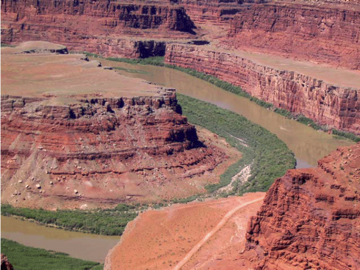
The likely story is that the streams once flowed across nearly flat lowlands. Then, uplift of the rocks began, giving the streams a steeper slope to the sea and so speeding their flow and causing them to erode. But, the uplift was gradual enough that the streams held their old courses. The streams cut downward without a change in pattern, which is called incision. Canyonlands contains clear examples of incised meanders. Similar features are preserved throughout the Colorado Plateau, documenting widespread uplift of the Plateau.
Much of geology involves study such as this; the history of a region produced the modern features. One can often learn much about that history by understanding the modern features and how they were formed. Clearly, if we did not know what conditions produce meandering streams today, we would not know what conditions likely occurred in the past when the meandering streams developed. The geological saying that captures this idea is “The present is the key to the past.”
SINKING MUD
Down at the Mississippi Delta, we saw that the mud under New Orleans is compacting under its own weight, contributing to sinking of the city. A couple of other things also contribute to the sinking.
As the delta grows, the weight of the mud pushes down the rock beneath, with soft, hot rock much farther below flowing away laterally, like water under your behind if you sit on a water bed. The sinking is not instantaneous. And, just as the strength of the water-bed cover spreads the dimple around your behind when you sit down, a fairly large region around the delta is pushed down by the weight of the delta. So add some mud anywhere near New Orleans, and you get a little sinking in New Orleans for a while.
Perhaps more importantly, as we saw with mass movements at the Grand Tetons (and as you can see in the picture of Canyonlands on the previous page, in the cliff on the inside of the meander), rocks tend to fall off steep slopes. Sometimes a single rock falls, or a thin layer of rocks slides. Other times, large thicknesses of material move. The Mississippi Delta is a giant pile of mud towering above the deep waters of the Gulf of Mexico, and that “cliff” is subject to downward motion of its materials. Some of this occurs along faults that are something like pull-apart Death-Valley-type faults—the fault intersects the Earth’s surface well inland, sloping down toward the Gulf, and the mud on top slides down and toward the Gulf.
After Hurricane Katrina devastated New Orleans, geologists renewed their efforts to understand what is going on geologically—such understanding should help in planning how to slow down the next disaster. An argument has erupted about the relative importance of the various reasons for sinking in and near New Orleans, with faulting probably more important (and mud compaction less important) than previously believed, and with sinking of the rock beneath minor but not zero. All are almost certainly contributing, but with a little work to figure out just how much to blame on each one. Naturally, all of them contributed to lowering of the surface, and sediment deposited from the river's floods filled that space—the river doesn't really care why the surface dropped, and deposits sediment in low places formed by any process.
Wrap Up
Review the Unit 6 Introduction
You have reached the end of Unit 6! Double-check the list of requirements on the Unit 6 Introduction page and the Course Calendar to make sure you have completed all of the activities listed there.
Unit 6 Overview
Review of the main topics and ideas you encountered in Unit 6.
Water, Rivers, Floods, and Caves: Canyonlands, Delta and Mammoth Cave
- Most rain evaporates especially from plants, most of remainder soaks in.
- Soil and shallow rock usually have air as well as water in spaces; deeper, below water table, spaces all water-filled.
- Water table looks like a smoothed version of the ground surface, and hits surface at streams.
- “Sponge” of ground fills during rains, drains to keep streams running between rains.
- Water table rises during wet times, sinks during dry times.
Rivers Move Rocks
- Rivers get water, and rocks by mass movement.
- If more rocks arrive than water can move, rocks pile up, steepening stream so it can move more rocks.
- Sticky, small clay particles favor a single, deep meandering channel that moves suspended load up in channel.
- Lots of sand, gravel or larger rocks that don’t stick together favor many shallow braided channels.
Dams Make a Big Difference
- Sediment builds deltas to fill reservoirs formed by damming rivers.
- A delta builds out but also up, “backing up” sediment to bury fields and houses for some distance upstream.
- Regions downstream of dams no longer get floods.
- Which makes a huge difference for what lives on floodplain (favors humans over nature).
- Without floods, big rocks are no longer moved by rivers.
- Clean water released by dams picks up sand, removing sand bars and affecting river ecosystems.
Ignoring rivers can be dangerous
- A delta is a big pile of sediment, which compacts under its own weight.
- The Mississippi delta is miles thick, compacts a lot.
- The natural sinking is balanced by new mud from the annual flood.
- Humans hate mud on carpet, so raise natural levees to keep river out of houses.
- But sinking continues—most of New Orleans has subsided below river and sea level.
- Wetlands below New Orleans have been lost as levees and dredging for shipping kept flood mud from balancing sinking.
- A low city by a high river and sea with no wetlands to slow storm surges brought huge hurricane disaster.
- Scientists, disaster planners, many journalists and others repeatedly warned that this would happen…
- The sinking continues; rebuilding without major changes will cause the next disaster to be even worse.
Caves are Cool
- Some rocks (esp. limestone) dissolve easily; if cracks rare so dissolving focused, get sinkholes from surface, caves beneath, springs, etc.=karst.
- If cave dries, loss of soil CO2 to cave deposits dissolved limestone as cave formations.
- Water goes through caves quickly; pollution discharged today may harm someone tomorrow.
- For other rocks, water moves much more slowly; pollution may not “get” anyone for a while, but once it does, clean-up is very hard and slow.
- Some clean-up options, but best to keep poisons out of ground.
Reminder - Continue to work on Exercise #3. See Course Calendar for specific due dates.
Supplemental Materials
Following are some supplementary materials for Unit 6. While you are not required to review these, you may find them interesting and possibly even helpful in preparing for the quiz!
- Website: Canyonlands National Park
- Website: Delta National Wildlife Refuge
- Website: Mammoth Cave National Park
To read about the restoration of the Elwha River, go to the Olympic National Park website, and in particular to the Elwha River Restoration page.
Comments or Questions?
Please feel free to send an email to ALL of the teachers and TA's through Canvas conversations with any questions. Failure to email ALL teachers and TA's may result in a delayed or missed response. See "How to send email in GEOSC 10" for instructions
Want to see more?
Here are some optional vTrips you might also want to explore! (No, these won't be on the quiz!)
Canyonlands National Park
(Provided by UCGS)
Mammoth Cave National Park
(Provided by UCGS)
Jean Lafitte National Historical Park and Preserve
(Provided by National Park Service)