Geospatial Analytic Methods
Geospatial Preparation of the Environment (GPE)
- The geospatial intelligence preparation of the environment (GPE) analytic method is based on the intelligence cycle and process. According to the National Geospatial-Intelligence Agency(NGA) [1], the steps are:
- 1. Define the Environment: Gather basic facts needed to outline the exact location of the mission or area of interest. Physical, political, and ethnic boundaries must be determined. The data might include grid coordinates, latitude and longitude, vectors, altitudes, natural boundaries (mountain ranges, rivers, shorelines), etc. This data serves as the foundation for the GEOINT product.
- 2. Describe Influences of the Environment: Provide descriptive information about the area defined in Step 1. Identify existing natural conditions, infrastructure, and cultural factors. Consider all details that may affect a potential operation in the area: weather, vegetation, roads, facilities, population, languages, social, ethnic, religious, and political factors. Layer this information onto the foundation developed in Step 1.
- 3. Assess Threats and Hazards: Add intelligence and threat data, drawn from multiple intelligence disciplines, onto the foundation and descriptive information layers (the environment established in the first two steps). This information includes: order-of-battle; size and strength of enemy or threat; enemy doctrine; nature, strength, capabilities and intent of area insurgent groups; effects of possible chemical/biological threats. Step 3 requires collaboration with national security community counterparts.
- 4. Develop Analytic Conclusions: Integrate all information from Steps 1-3 to develop analytic conclusions. The emphasis is on developing predictive analysis. In Step 4, the analyst may create models to examine and assess the likely next actions of the threat, the impact of those actions, and the feasibility and impact of countermeasures to threat actions.
PPDAC: Problem, Plan, Data, Analysis, and Conclusions
De Smith and Goodchild [2] examined geospatial analysis process in the broader context of analytical methodologies. The typical process of geospatial analysis typically follows a number of well-defined and iterative stages:
- problem formulation;
- planning;
- data gathering;
- exploratory analysis;
- hypothesis formulation;
- modeling;
- consultation and review; and
- ultimately, final reporting and/or implementation.
In the whole, geospatial analysis can be seen as part of a decision process and support infrastructure. The process from problem specification to outcome is, in reality, an over-simplification, and the analytical process is more complex and iterative than the steps suggest. GIS and related software tools that perform analytical functions only address data gathering, analysis, and modeling. As de Smith and Goodchild point out, the flow from start to finish is rarely the case. Not only is the process iterative, but at each stage one often looks back to the previous step and re-evaluates the validity of the decisions made. Mackay and Oldford in de Smith and Goodchild [3]described a spatial analysis method in terms of a sequence of steps labeled PPDAC: Problem; Plan; Data; Analysis; and Conclusions. The PPDAC approach is shown in the below figure.
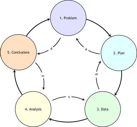
As can be seen from the diagram, although the clockwise sequence (1→5) applies as the principal flow, each stage may, and often will, feed back to the previous stage. In addition, it may well be beneficial to examine the process in the reverse direction, starting with Problem definition and then examining expectations as to the format and structure of the Conclusions. This procedure then continues, step-by-step, in an anti-clockwise manner (e→a) determining the implications of these expectations for each stage of the process.
PPDAC develops evidence. Evidence, in the context of this discussion, refers to the information that is gathered by exploratory analysis of spatial and temporal data. These methods include remote sensing and GIS to develop intermediate products. "Exploratory data analysis (EDA) is about detecting and describing patterns, trends, and relations in data, motivated by certain purposes of investigation. As something relevant is detected in data, new questions arise, causing specific parts to be viewed in more detail. So EDA has a significant appeal: it involves hypothesis generation rather than mere hypothesis testing" (Exploratory Analysis of Spatial and Temporal Data, Springer, 2006). Ultimately, what is evidence is defined by the intelligence producer. Ideally, "evidence" in the context of the framework of the problem should include: the context and the scientific and intuitive evidence.