Case Study: Miami, Florida
Case Study: Miami, Florida
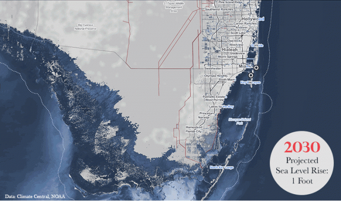
Of the major U.S. cities that face the greatest uncertainty related to sea level rise, Miami may be the poster child. The greater Miami area of south Florida faces higher than average sea level rise rates due to its location on the Atlantic seaboard (see Module 4). This, along with its low-lying topography and its porous limestone geology, all conspire to create a very uncertain future for the metropolitan area of more than 6 million. Examination of any maps of projected sea level rise in south Florida should set alarms ringing for the viewer. Take a look at this animation of sea level rise based on data from the Green Policy 360 [1].
Part of the metro region, Miami Beach is a city of 91,700 people situated on a barrier island connected to the mainland and the city of Miami by bridges. Most people associate Miami Beach with glitzy wealth, beautiful Atlantic beaches, and a tropical climate. They may not be aware of the challenges associated with the rising seas coupled with the geography and geology of the area.
The geology of this part of Florida makes it especially susceptible to sea level rise related issues. The Florida peninsula is composed of a limestone platform, and the barrier shoreline that Miami Beach occupies sits upon this platform. In addition, the Florida peninsula is low in elevation and Miami Beach has a maximum elevation of only a little over 1.5 m. The lowest elevations are on the bay side of Miami Beach. This is the area discussed in the video “Is Miami Doomed?”. You can explore the effects of sea level rise on Miami Beach at the NOAA Sea Level Rise Viewer [2], which allow you to search for a location and manipulate projected sea levels and visualize the effects on the chosen location.
In addition, the geology presents other challenges: the oolite limestone platform is highly porous, so seawater can infiltrate beneath the ground and come up from below during high tides. Furthermore, the design of the older drainage systems that rely on gravity flow to the ocean has resulted in seawater backing up onto roadways during high tides. This adds to the effects of “sunny day flooding” which Miami is becoming accustomed to. The porous nature of the limestone geology also precludes using methods like levees and dikes to hold back rising seas, as the water just migrates under any structures put in its way.
Let’s consider some of the reasons behind the sunny day flooding and king tides that are disrupting the utopic life there. First, of course, is sea level rise. We learned in Module 4 that parts of the east coast of the U.S. are suffering from greater rates of sea level rise than most places. And Miami is one of these locations. Research has shown that in addition to eustatic sea level rise, there is a combination of other factors contributing to sea level rise along the southeastern coast of the U.S. In addition, there are king tides, which occur seasonally, during the fall and early winter. King tides are a natural phenomenon determined by the predictable movements of the Earth, Moon, and Sun, but exacerbated by local weather patterns and regional ocean conditions. King tides occur when the Earth, Moon, and Sun are aligned at perigee (Moon is closest to the Earth) and perihelion (Earth is close to the Sun). These conditions result in the largest tidal range seen over the course of a year. These factors, combined with a unique set of regional geological characteristics, and high exposure to tropical cyclone storm surges, make south Florida a highly sea-level challenged part of the U.S.
How sustainable is the economic powerhouse of Miami Beach? What future lies ahead, and for how long can business as usual be maintained? What adaptation plans are being made?
The flooding experienced today in Miami is just the beginning, given the sea level rise projections we have already discussed. In the 2016 Atlantic video, Is Miami Doomed? [3] The mayor and city manager of Miami Beach both sound optimistic and are pushing forward with innovative ideas for adaptation, such as the installation of pumps, raising road levels, etc. The drainage systems are being redesigned with pumps to return the water to the ocean.
But this video avoids some difficult questions about the complexity, costs, and sustainability of these approaches. To begin, there is the question of scale. It seems foolish to think that the whole of the city of Miami Beach can be raised in elevation, not to mention the rest of the city of Miami. Many other authors and experts have raised important questions about how long reliance on pumping water out into Biscayne Bay and other current approaches can last as sea levels rise. The larger policy questions of how to maintain the infrastructure such as sewage and drinking water, etc., and provide an equitable quality of life for all citizens in the future loom over Miami.
Miami Dade County Adaptation Planning
Miami Dade County Adaptation Planning
Please explore this Story Map of Miami Dade County [4]resiliency planning areas. It sets out the problem and shows examples of the solutions that are currently in process. As you read about each approach, try to envision how this approach may work in 30 or 50 years from now with projected rates of sea level rise. Make notes about each on and complete the Learning Check Point below.
Learning Check Point
To explore these approaches in more detail, go to Miami Dade County’s Sea Level Rise and Flooding [5].
Clearly, the costs associated with some of these adaptation plans going forward are astronomical. The question of how they will be funded, even in a city of great wealth, such as Miami, is a difficult one. Miami has begun to address the issue of raising funds to pay for infrastructure adaptation with a $400 Million Miami Forever Bond, which is helping to pay for infrastructure upgrades. But also, rate increases for sewage treatment are necessary, pointing to many difficult financial decisions for city leaders.
Environmental fellows from Harvard Kennedy School of public policy examine important policy and funding aspects for adaptation action for Miami in this article: Rising Seas, Sinking Infrastructure: Miami’s Climate Conundrum [6]
The opening video asks:
- How can Miami protect $3.5 trillion in exposed assets due to climate by 2070?
- What are policymakers doing to address aging infrastructure?
- How can the public be engaged in planning for a different future?
In conclusion, the Kennedy School’s writers recommend the following actions for Miami and other coastal cities:
“Addressing such a daunting problem requires a coordinated strategy, drawing expertise from a diverse array of stakeholders. Cities facing similar challenges should start by taking the following actions:
Expand the group of “decision makers” to include those who aren’t normally offered a seat at the technocrat’s table. Expertise from all angles is necessary to communicate the issues as they relate to people’s daily lives, and then inspire collective action. It is also important that resources are allocated with an eye towards equity, justice, and public health.”
- Establish consensus on sea-level rise projections. Decision-making agencies should use the same future projections and build these into planning. The Southeast Florida Regional Climate Change Compact has implemented unified sea level rise projections.
- Develop a standard operating procedure around classifying asset risk. Decide whether to harden to high, medium, or low sea-level rise projections based on the asset’s importance and its exposure during smaller flood events versus Category 5 hurricanes.
- Consider whether to allocate a portion of the regular capital budget to adaptation projects, or whether to develop an entirely separate climate adaptation budget and funding stream, such as through a bond measure.
- Emphasize the importance of long-term thinking. Almost half of city mayors are elected to two-year terms. Calling for changes that benefit residents in fifty years becomes difficult if residents vote based on short-term actions.
Learning Check Point
Reading the article Rising Seas, Sinking Infrastructure: Miami’s Climate Conundrum [6]. The article states: “Incremental infrastructure investments are an improvement, but difficult questions remain. Climate change may cause between 2.5 and 6.75 feet of sea level rise in Miami by 2100.[7] Some experts project even higher levels...” Make a list of the difficult questions as you see them, then complete the Learning Check Point activity below.