Cost-Benefit Analysis
Cost-Benefit Analysis
How can stakeholders’ choose among these strategies?
One of the most frequently used methods for determining which strategies communities should use to prepare for sea level rise is cost-benefit analysis. Cost-benefit analysis is a systematic approach to decision-making that compares alternatives based on their ratio of benefits to costs. For example, imagine a community is choosing between managed retreat and beach nourishment/restoration as options for protecting a coastal development from sea level rise and other coastal hazards over the next ten years. For the managed retreat option, relocating homes and businesses further inland and converting coastal areas to parkland is expected to cost $4 billion, but the associated reduction in vulnerability and increased tourism from the new parks is expected to bring $6 billion in benefits over the next ten years. The ratio of benefits to costs for the managed retreat option would therefore be 6/4, or 1.5. For the beach nourishment/restoration option, adding millions of tons of sand to the beach is expected to cost $2 billion over ten years but will also bring $4 billion in benefits by reducing vulnerability and improving the recreational value of area beaches, for a benefit to cost ratio of 4/2, or 2. Because the ratio of benefits to costs for the next ten years is higher for the beach nourishment/restoration option (2) than for the managed retreat option (1.5), cost-benefit analysis suggests that, at least for the next decade, beach nourishment/restoration is the better strategy for protecting the community.
| - |
Managed Retreat  |
Beach Nourishment/Restoration 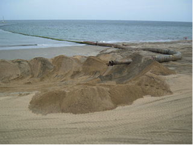 |
|---|---|---|
| Total Costs | $4 billion | $2 billion |
| Total Benefits | $6 billion | $4 billion |
| Benefits/Cost Ratio | 1.5 | 2.0 |
Types of costs and benefits
As this example suggests, strategies for preparing for sea level rise can have many different types of costs and benefits, including changes to vulnerability and the local economy. The table below summarizes some of these possible costs and benefits.
| Possible Costs | Possible Benefits |
|---|---|
| New or continuing construction, maintenance, and operation costs | Avoided construction, maintenance, and operation costs |
| Economic costs | Economic benefits |
| Residual or increased vulnerability | Reduced vulnerability |
| Environmental degradation | Environmental benefits |
| Negative impacts on community design/livability | Improvements to community design/livability |
| Decreased equity | Increased equity |
| Inconsistency with local goals, plans | Consistency with local goals, plans |
Types of possible costs and benefits for sea level rise mitigation strategies. Adapted from “Urban Waterfront Adaptive Strategies,” City of New York Department of Planning, June 2013 [5]
This list is not exhaustive, but instead provides examples of the types of costs and benefits frequently considered when planning for sea level rise and related hazards. In a real participatory planning environment, stakeholders are often asked to brainstorm lists of possible costs and benefits, which may be more or less extensive than those listed here.
Quantitative or Qualitative
Cost-benefit Analysis: Quantitative or Qualitative?
Some of these costs and benefits can be assessed quantitatively in terms of dollars spent, saved, or earned. Construction, maintenance, and operation costs can be estimated and compared for different strategies: for example, the costs of continuing to replenish and maintain a sandy beach versus the cost of replacing it with a sea wall (including the cost of maintaining the sea wall and operating any gates or other features). Economic costs and benefits– including jobs created to build or maintain new infrastructure; impacts on major local industries such as shipping, fishing, or tourism; and effects on property values – can also be modeled, quantified, and compared.
However, other types of costs and benefits may not be easily assessed in dollar terms. Rather than use quantitative analysis, these benefits, and costs should be assessed qualitatively using a subjective scoring system. The first example in this section – reducing vulnerability by managing retreat or beach nourishment/restoration – is assumed to be quantifiable in terms of dollars saved. This may be true for the exposure component of vulnerability, which can be quantified in terms of changes in the number and value of homes and businesses exposed to sea level rise-enhanced flooding. However, it is much more difficult to assign a dollar value to changes in the social dimensions of vulnerability, such as the reductions to residents’ adaptive capacity that may occur if managed retreat from a coastal neighborhood disrupts social networks. Instead of assigning a dollar value to the residents’ adaptive capacity, stakeholders in a participatory planning exercise can assign subjective scores, perhaps by rating the costs and benefits for residents’ adaptive capacity on a scale of 1 to 10 for each policy option. Average cost and benefit scores are compared to determine which option would be most beneficial (or least costly) for adaptive capacity. These subjective cost-benefit scores can then be reweighted (multiplied by a constant value) so that they can be compared and combined with scores for other types of costs and benefits, including those assessed in dollar terms.
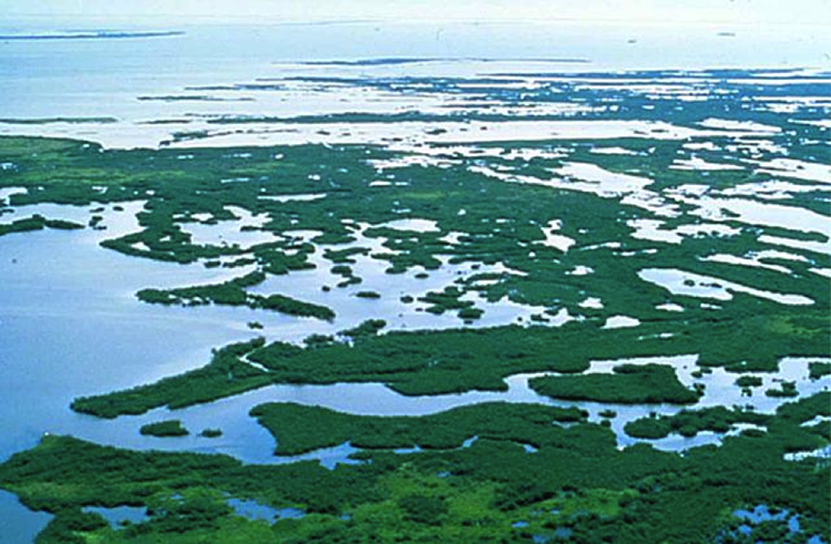
Like social vulnerability, environmental and design/livability costs and benefits can be challenging to quantify. For environmental costs and benefits, it may be possible to assign a dollar value using an ecosystem services model, which prices the cost or benefit of a change to environmental functions in terms of its value to society. For example, the environmental benefits of a strategy that maintains or increases the extent of coastal wetlands could be quantified in terms of the wetland’s increased ability both to protect coastal property from storm surge and to provide habitat for commercially valuable fish.
In Module 9 we looked at an example of cost-benefit analysis for managed realignment in the United Kingdom and considered the benefits of ecological services provided by coastal marshes, and how they add to the benefits of managed realignment projects.
However, this increase in wetlands could provide other benefits – such as habitat for an endangered species – that are more difficult to quantify. Similarly, impacts of a strategy on community design/livability – such as making a community more attractive and walkable or providing better access to amenities such as grocery stores or public transportation – could be quantified in terms of changes in public health and transportation costs, but aesthetic considerations would remain highly subjective and are better assessed qualitatively.
Costs and benefits associated with equity and compatibility with local plans and goals may be the most difficult to quantify. Equity considers who will pay and who will benefit from implementing a given strategy. For example, although a cost-benefit analysis may show that the benefits of a particular strategy far outweigh the costs, equity considerations may reveal that wealthy landowners or corporations will receive most of the benefits, while the most vulnerable and disadvantaged stakeholders will bear most of the costs. In this situation, stakeholders may decide that the large decreases in equity associated with implementing such a strategy outweigh its other benefits.
As we saw with the example of Toms River, NJ, strategies for preparing for sea level rise can be seen as an obstacle to existing plans or goals – such as attracting new businesses, maintaining tourism, or increasing the stock of affordable housing, and can complicate cost-benefit analysis. If stakeholders oppose a strategy due to these conflicts, the strategy could be ranked higher in the cost column than if there were no conflicts of this kind.
Modeling Costs and Benefits for Coupled Human-Environment Systems
Modeling Costs and Benefits for Coupled Human-Environment Systems
Computer models are an essential tool for studying costs and benefits. Physical models of the ocean and shoreline can be used to study how protective structures such as sea walls and levees can reshape the coastline by changing currents, waves, and erosion. From the outputs of these models, scientists can calculate costs and benefits in terms of losses or gains in coastal property, in amenities such as beaches, or in habitat. Economic or demographic models can then be used to study how these changes in coastal processes, landforms, and ecosystems may interact with the local economy or population trends, potentially resulting in additional costs or benefits (such as increasing poverty or growing the tax base). Urban planning and design models can assess the effects of these changes in the physical and social environment on urban spaces, including changes in traffic patterns on city streets or in sight lines (views) from scenic coastal hotels or parks.
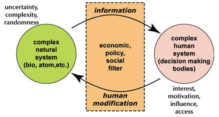
As these examples suggest, human and environmental systems in the coastal zone are closely coupled: human actions reshape the natural environment, and changes in the natural environment reshape human communities and infrastructure. Therefore, to understand the costs or benefits of a proposed strategy for preparing for sea level rise and related hazards, scientists and decision-makers should consider these complex, reciprocal interactions between human and environmental processes. Because computer models are able to capture these complex interactions, they are often one of the best tools for understanding the costs and benefits that these interactions may cause. Models may be particularly useful when attempting to understand whether combining two or more sea level rise strategies will change the human-environment system in ways that lead to unexpected costs or synergistic benefits. The next section considers some of the possible benefits of combining strategies. Fittingly, coming near the end of the course, this is one of the most advanced views of the Earth System we have had this semester.
Combining Strategies
Combining Strategies
The above discussion shows how cost-benefit analysis can be used to compare individual strategies for preparing for sea level rise and related coastal hazards. However, the most cost-effective option is often not a single strategy, but a combination of synergistic strategies. For example, when used alone, breakwaters or artificial reefs can be used to slow coastal erosion, but are not effective at preventing flooding due to sea level rise and storm surge. However, these strategies can be combined with other complementary strategies – such as levees or beach/dune reconstruction – that can mitigate sea level rise and storm surge flooding but are not as good at slowing coastal erosion. Combining strategies can also be an effective way to meet multiple design goals. For example, including a waterfront park in a plan for managed retreat can reduce the exposure of coastal infrastructure to flooding while also fulfilling other goals, such as creating new space for recreation and environmental restoration.
Learning Check Point
This exercise is not for credit, but you are required to understand this material for the formal assessments in this module.
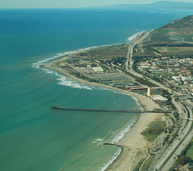
Stakeholders in Ventura, California have chosen to combine several strategies for reducing erosion at Surfer’s Point.
Re-visit this NOAA article, which was also presented in Module 9, Restoring Surfer's Point [10], then answer the following questions:
In addition to the benefits of implementing complementary strategies in one place, communities should also recognize that the types of strategies that are most beneficial will vary from place to place across the community’s jurisdiction – strategies that are highly beneficial in one area of the community may not be as beneficial in another, and may even be harmful. Thus, communities should consider adopting not only multiple complementary strategies in one area, but also different sets of complementary strategies for different areas. The next section discusses how communities, governments, and stakeholders can use geographic information systems to better understand how differences in the social and physical landscape across their jurisdiction may affect the suitability of these strategies from place to place.
Learning Check Point
Learning Check Point
Please take a few moments to think about what you just learned, then answer the following questions to test your knowledge.