Welcome to Colorado!
Colorado is known as the "Centennial State" and is the 8th largest state in the U.S. by area, at a little over 104,000 square miles. As a point of reference, it is over twice the size of Pennsylvania. However, it has only the 21st highest population, at just over 5.6 million people as of 2018. (Pennsylvania is 5th at around 12.8 million people.) The capital is Denver, which is known as the "Mile High City" because most of the city is at or above 1 mile above sea level. While known for its mountains, a significant portion of Colorado is part of the Great Plains and is nearly flat. Even the plains are at a high elevation, and in fact, Colorado has the highest average elevation of any state in the U.S. Colorado has more peaks higher than 14,000 feet (58 of them!) than any state in the country. If you travel to Colorado for any amount of time, you will no doubt overhear discussions about these "fourteeners." It is nearly a universal pastime to climb fourteeners.
As you will read below, Colorado has a very diverse landscape and culture. It is known for the availability of outdoor activities (hiking, skiing, camping, white water rafting, biking, etc.), but also has an interesting mixture of modern and historic culture and practices. Farming and ranching are important to its economy and culture, but so are tourism, higher education, and high tech industries, among many other things. It is a wonderful state to explore!
As you probably recall, we will spend most of our time in Denver and Boulder, but will also drive through the mountains to the Western Slope town of Paonia. We will thus experience a variety of Colorado culture and scenery, from the Eastern Plains to the Front Range, as well as the Western Slope. More details on these regions below.

Regions and Geography
Colorado has many local regions and other geographic features, but the major ones that we will experience are as follows:
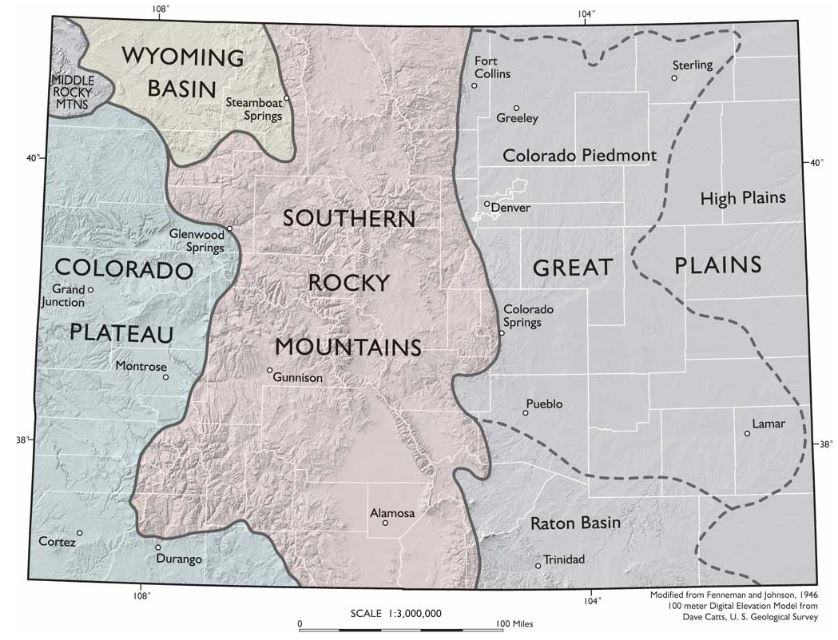
- The Front Range, which is where most of the population of the state resides. In figure 10.4 below, the front range is roughly the easternmost portion of the Southern Rocky Mountains but also is generally understood to encompass the westernmost portion of the Great Plains, including parts of the Colorado Piedmont. (The boundaries of the Front Range are not distinct). The Front Range is often thought of as the foothills of the Rockies, and you will see why that is when we travel there. All of the major population centers of Colorado, including Denver, Fort Collins, Boulder, and Colorado Springs are considered part of the Front Range. According to the Colorado Encyclopedia, about 4.5 million of the state's 5.6 million people live in the Front Range. Red Rocks Amphitheater, the famous outdoor concert venue and geologic feature lies in the Front Range just outside of Denver. (We'll visit this, too!)
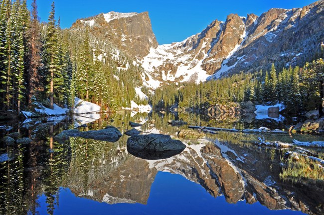
- The Western Slope, which is generally understood as the area of the state that is on the other side of the Continental Divide (see below). In Figure 10.4 below, you can visualize the Western Slope if you mentally draw a north-south line through the middle of the Southern Rocky Mountains province - the Western Slope is everything to the west of that line. (Sorry, I could not find an image of this exact province.) The Western slope covers the eastern third of the state, but only has about 10 percent of the residents. Perhaps most importantly, it has about 70 percent of the state's water. The Western Slope is mostly mountainous and contains most of the "classic" Rocky Mountain geography (e.g. the image of Rocky Mountain National Park above). Most of the mountain towns and ski resorts (Vail, Aspen, Keystone, Breckenridge, etc.) lie in the Western Slope. However, most of the westernmost portion is part of the Colorado Plateau and has desert features such as mesas and plateaus. Paonia is a very small town and does not appear on the map below, but it lies almost directly on the boundary between the Southern Rocky Mountains and the Colorado Plateau, just northeast of Montrose.
- The Eastern/Great Plains, as you can see in the image below, covers about the eastern third-to-half of the state. This is characterized by mostly flat land covered in prairie grasses and dotted with small towns. Between the towns are generally wide open spaces covered in farms, ranches, and some public lands. We won't really experience this area, but Denver lies at the edge of it, and you can see the Great Plains' physical geography while traveling from the Denver airport to the city.
See the video below the image for a good explanation of how the Rocky Mountains and the Front Range formed. Note the explanation of why Red Rocks and other parts of the Front Range are sedimentary rocks (made from ancient sediments such as sand and silt) that were originally layered on top of the granite "basement" rock, and the Rocky Mountains themselves are made of granite that was pushed up via oceanic subduction. Some of this granite core is over 1 billion years old! (Side note: Geology is awesome!)
NARRATOR: On our journey south along the Rocky Mountains we're entering a very different landscape. From Montana southward the Rockies are made from ancient granite 1.7 billion years old. Granite makes up much of the deepest part of the continental crust. That's why geologists call this rock the basement.
The Canadian Rockies are built from sedimentary rocks piled up on top of the continental foundations. So why does granite suddenly appear here in the American Rockies? But there's an even greater puzzle. Mountains usually form close to plate boundaries, but the southern Rockies sit a long way from the plate margin.
The Front Range in Colorado is a thousand miles from where the Pacific and North American plates actually meet. Geologists have come up with an explanation. They believe that the subducting Pacific ocean plate is responsible. Ocean crust had been pushed deep into the mantle beneath North America for a hundred million years when something unusual happened. Plates started to subduct at a shallower angle. Instead of plummeting steeply, it sliced beneath North America horizontally. This change had dramatic consequences.
DR. KIRK R. JOHNSON: The big oceanic plate in the Pacific didn't go deep down it went in shallow like a spatula under a pizza. So something happened sixty-eight million years ago over in California. That plate drives under North America but instead of diving deeply it comes in shallow and a thousand miles away from the coast up from the ground throughout the Rocky Mountains.
NARRATOR: For millions of years the ocean plate scraped along the underside of North America. It created friction breaking up the basement granite of the North American plate and punching it upward. Structural geologist Karl Karlstrom demonstrates.
PROF. KARL E. KARLSTROM: Because it was at a shallower angle beneath North America it was scraping along the base of North America. When that happens it puts the plate under compression like this because it's being both pushed at the end and scraped along at the bottom. So it squeezes, pushes up the mountains, and it transferred this mountain building from the edge to great distance from the plate margin.
NARRATOR: The shallow angle trajectory of the Pacific Ocean plate explains why these mountains formed so far inland and it also explains the presence of granite. Thrust up through layers of sedimentary rock the broken granite became the Rocky Mountains of the south.
Red Rocks Park, Denver Colorado, a landscape forged by granite uplift. The granite mountains here have been pushed up for miles. On top of the granite lie spectacular red slabs of rock known as flat irons. They're the patchwork remains of sedimentary rock that once blanketed the entire granite basement. Kirk Johnson demonstrates how these granite peaks punched up through the layers of red rock around them.
KIRK JOHNSON: I'm going to use my assistants Veronica and Ian to help me explain how the Rocky Mountains in Colorado formed. Imagine if you will that Veronica and Ian are composed of 1.7 billion-year-old metamorphic rocks, the basement Rock of Colorado.
NARRATOR: Before the mountains grew, layers of sedimentary rock covered the granite.
KIRK JOHNSON: And then in about sixty-eight million years ago the mountain where Ian is starts to break and lift up and move up so you see the uplift forming. What's happening is that layer of sediments being deformed is bent and these are the flatirons at Red Rocks. As the mountain comes up overlying sediment eroded off and deposited into the adjacent basin and eventually Ian's granitic back is exposed as the core of the Rocky Mountains. Veronica remains deeply buried beneath Denver still covered with deep sediments and the sediments eroded off the uplifting Rocky Mountains.
To Read Now
Please read the following sections of this article from Encyclopaedia Britannica:
- Intro
- Land
- Climate
- Settlement patterns
Continental Divide
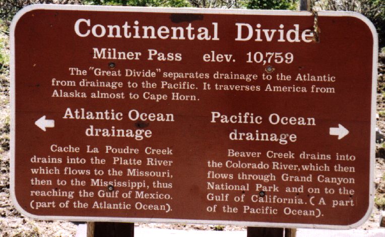
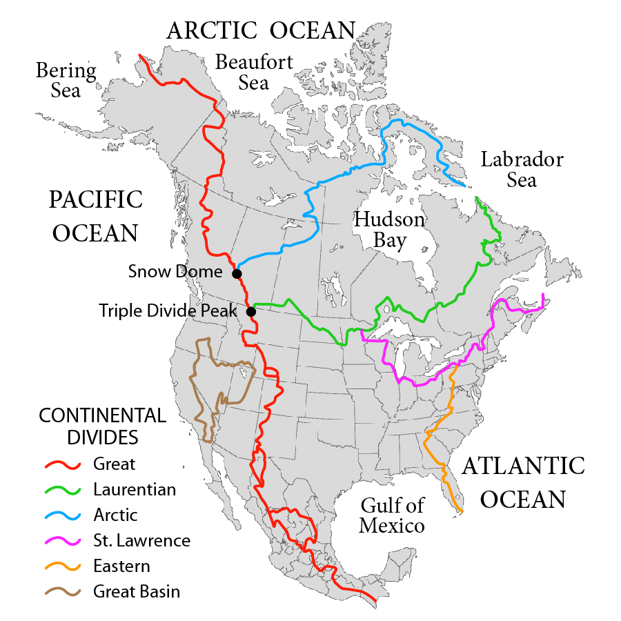
Another well-known feature of the state is the Continental Divide, sometimes referred to as the Great Divide. A continental divide is defined by National Geographic as "a naturally occurring boundary or ridge separating a continent’s river systems. Each river system feeds into a distinct ocean basin, bay, or sea." As you can see in the image below, there are a number of continental divides in North America. Each of these lines is the boundary between two major drainage basins. The rivers and streams in each basin lead to a specific large body of water.
For example, the Eastern Continental Divide runs through Pennsylvania. Flowing water to the east of the divide ends up in the Atlantic Ocean, and west of the divide ends up in the Gulf of Mexico. In Colorado, water to the west of the Continental Divide flows to the Pacific Ocean, and to the east flows to the Gulf of Mexico (and ultimately the Atlantic Ocean). You may see signs while traveling through the mountains of Colorado like the one below that mark portions of the Continental Divide. There is also a trail that roughly follows the divide that is a national park - Continental Divide National Scenic Trail.