Identification
Digital Orthophoto Quads (DOQs) are raster images of rectified aerial photographs. They are widely used as sources for editing and revising vector topographic data. For example, the vector roads data maintained by businesses like NAVTEQ and Tele Atlas, as well as local and state government agencies, can be plotted over DOQs then edited to reflect changes shown in the orthoimage.
Most DOQs are produced by electronically scanning, then rectifying, black-and-white vertical aerial photographs. DOQ may also be produced from natural-color or near-infrared false-color photos, however, and from digital imagery. The variations in photo scale caused by relief displacement in the original images are removed by warping the image to compensate for the terrain elevations within the scene. Like USGS topographic maps, scale is uniform across each DOQ.
Most DOQs covers 3.75' of longitude by 3.75' of latitude. A set of four DOQs corresponds to each 7.5' quadrangle. (For this reason, DOQs are sometimes called DOQQs--Digital Orthophoto Quarter Quadrangles.) For its National Map, USGS has edge-matched DOQs into seamless data layers, by year of acquisition.
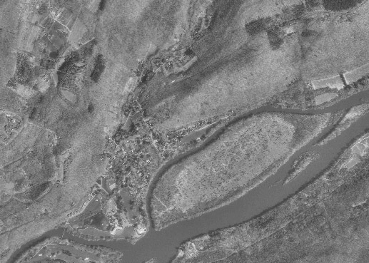
Portion of a USGS Digital Orthophoto Quad (DOQ) for Bushkill, PA.
Data Quality
Like other USGS data products, DOQs conform to National Map Accuracy Standards. Since the scale of the series is 1:12,000, the standards warrant that 90 percent of well-defined points appear within 33.3 feet (10.1 meters) of their actual positions. One of the main sources of error is the rectification process, during which the image is warped such that each of a minimum of 3 control points matches its known location.
Spatial Reference Information
All DOQs are cast on the Universal Transverse Mercator projection used in the local UTM zone. Horizontal positions are specified relative to the North American Datum of 1983, which is based on the GRS 80 ellipsoid.
Entities and Attributes
The fundamental geometric element of a DOQ is the picture element (pixel). Each pixel in a DOQ corresponds to one square meter on the ground. Pixels in black-and-white DOQs are associated with a single attribute: a number from 0 to 255, where 0 stands for black, 255 stands for white, and the numbers in between represent levels of gray.
DOQs exceed the scanned topographic maps shown in Digital Raster Graphics (DRGs) in both pixel resolution and attribute resolution. DOQs are therefore much larger files than DRGs. Even though an individual DOQ file covers only one-quarter of the area of a topographic quadrangle (3.75 minutes square), it requires up to 55 Mb of digital storage. Because they cover only 25 percent of the area of topographic quadrangles, DOQs are also known as Digital Orthophoto Quarter Quadrangles (DOQQs).
Distribution
USGS DOQ files are in the public domain, and can be used for any purpose without restriction. They are available for free download from the USGS at http://earthexplorer.usgs.gov/, or from various state and regional data clearinghouses as well as from the geoCOMMUNITY site http://data.geocomm.com/doqq/ Digital orthoimagery data at 1-foot and 1-meter spatial resolution, collected from multiple sources, are available for user-specified areas from the National Map Viewer site http://nationalmap.gov/ , and even higer resolution imagery (HRO) for certain areas is available through the USGS Seamless Data Warehouse site at http://seamless.usgs.gov/
To investigate DOQ data in greater depth, including links to a complete sample metadata document, visit http://online.wr.usgs.gov/ngpo/doq/ You're also welcome to post a comment to this page to describe your source of DOQ data, and how you use it. FGDC's Content Standard for Digital Orthoimagery is published at http://www.fgdc.gov/standards/standards_publications/
| Try This! |
Explore DOQs with Global Mapper (dlgv32 Pro)Now it's time to use Global Mapper (dlgv32 Pro) again, this time to investigate the characteristics of a set of USGS Digital Orthophoto (Quarter) Quadrangles. The instructions below assume that you have already installed the Global Mapper / dlgv32 Pro software on your computer. (If you haven't, return to installation instructions presented earlier in Chapter 6). Note: Global Mapper is a Windows application and will not run under the Macintosh operating system. The questions asked of Penn State students that involve the use of Global Mapper are not graded.
|
| Try This! |
Assess the availability of Digital Orthoimagery via the USGS National Map ViewerThe National Map Viewer is an Internet Map Server application that provides a browsable map interface to the digital data layers that make up the National Map. The orthoimagery available through this interface has been gathered from several sources in addition to the USGS DOQ collection describe above.
|
| Practice Quiz | Registered Penn State students should return now to the Chapter 6 folder in ANGEL (via the Resources menu to the left) to take a self-assessment quiz about Photogrammetry. You may take practice quizzes as many times as you wish. They are not scored and do not affect your grade in any way. |
 |
Students who register for this Penn State course gain access to assignments and instructor feedback, and earn academic credit. Information about Penn State's Online Geospatial Education programs is available at http://gis.e-education.psu.edu. |