Since the eighteenth century, the preparation of a detailed basic reference map has been recognized by the governments of most countries as fundamental for the delimitation of their territory, for underpinning their national defense, and for management of their resources (Parry, 1987).
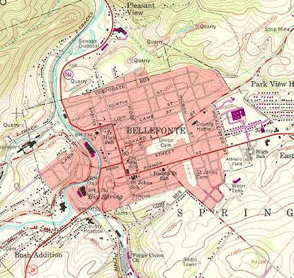
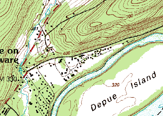
Specialists in geographic information recognize two broad functional classes of maps: reference maps and thematic maps. As you recall from Chapter 3, a thematic map is usually made with one particular purpose in mind. Often, the intent is to make a point about the spatial pattern of a single phenomenon. Reference maps, on the other hand, are designed to serve many different purposes. Like a reference book -- such as a dictionary, encyclopedia, or gazetteer -- reference maps help people look up facts. Common uses of reference maps include locating place names and features, estimating distances, directions, and areas, and determining preferred routes from starting points to a destination. Reference maps are also used as base maps upon which additional geographic data can be compiled. Because reference maps serve various uses, they typically include a greater number and variety of symbols and names than thematic maps. The portion of the United States Geological Survey (USGS) topographic map shown below is a good example.
The term topography derives from the Greek topographein, "to describe a place." Topographic maps show, and name, many of the visible characteristics of the landscape, as well as political and administrative boundaries. Topographic map series provide base maps of uniform scale, content, and accuracy (more or less) for entire territories. Many national governments include agencies responsible for developing and maintaining topographic map series for a variety of uses, from natural resource management to national defense. Affluent countries, countries with especially valuable natural resources, and countries with large or unusually active militaries, tend to be mapped more completely than others.
8.1.1 Legacy Data: USGS Topographic Maps
The systematic mapping of the entire U.S. began in 1879, when the U.S. Geological Survey (USGS) was established. Over the next century, USGS and its partners created topographic map series at several scales, including 1:250,000, 1:100,000, 1:63,360, and 1:24,000. The diagram below illustrates the relative extents of the different map series. Since much of today’s digital map data was digitized from these topographic maps, one of the challenges of creating continuous digital coverage of the entire U.S. has been to seam together all of these separate map sheets. The current process for topographic mapping in the U.S. is organized as The National Map (NationalMap.gov). But, since the process still relies on some data collected in traditional ways using the sheet-based organizational structure, we begin with a description of past topographic mapping practice.
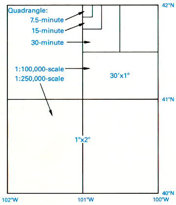
Map sheets in the legacy 1:24,000-scale series are known as quadrangles or simply quads. A quadrangle is a four-sided polygon. Although each 1:24,000 quad covers 7.5 minutes longitude by 7.5 minutes latitude, their shapes and area coverage vary. The area covered by the 7.5-minute maps varies from 49 to 71 square miles (126 to 183 square kilometers), because the length of a degree of longitude varies with latitude.
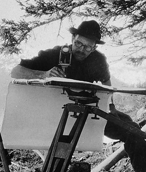
Through the 1940s, topographers in the field compiled by hand the data depicted on topographic maps. Anson (2002) recalls being outfitted with a 14 inch x 14 inch tracing table and tripod, plus an alidade [a 12 inch telescope mounted on a brass ruler], a 13 foot folding stadia rod, a machete, and a canteen (p. 1). Teams of topographers sketched streams, shorelines, and other water features; roads, structures, and other features of the built environment; elevation contours, and many other features. To ensure geometric accuracy, their sketches were based upon the geodetic control network (of about 240,000 locations of known position as described here: Horizontal Control PDF), as well as positions and spot elevations they surveyed themselves using alidades and rods. Depending on the terrain, a single 7.5-minute quad sheet might have taken weeks or months to compile. In the 1950s, however, photogrammetric methods (discussed in Chapter 7) permitted topographers to make accurate stereoscopic measurements directly from overlapping pairs of aerial photographs providing a viable and more efficient alternative to field mapping.
8.1.2. Scanned Topographic Maps
Many digital data products have been derived from the USGS topographic map series. The simplest of such products are Digital Raster Graphics (DRGs). DRGs are scanned raster images of USGS 1:24,000 topographic maps. DRGs are useful as backdrops over which other digital data may be superimposed. For example, the accuracy of a vector file containing lines that represent lakes, rivers, and streams could be checked for completeness and accuracy by plotting it over a DRG (subject to the age of the data on the DRG).
DRGs are created by scanning paper maps at 250 pixels per inch resolution. Since at 1:24,000 1 inch on the map represents 2,000 feet on the ground, each DRG pixel corresponds to an area about 8 feet (2.4 meters) on a side. Each pixel is coded from 0 to 12; the numbers stand for the 13 standard DRG colors. Like the paper maps from which they are scanned, DRGs comply with National Map Accuracy Standards (Standards and Specifications).
To investigate DRGs in greater depth, visit the USGS DRG site or search the Internet on “USGS Digital Raster Graphics”.
Try This:
Explore a DRG with Global Mapper (dlgv32 Pro)
You can use a free software application called Global Mapper (also known as dlgv32 Pro) to investigate the characteristics of a USGS Digital Raster Graphic. Originally developed by the staff of the USGS Mapping Division at Rolla, Missouri as a data viewer for USGS data, Global Mapper has since been commercialized but is available in a free trial version. The instructions below will guide you through the process of installing the software and opening the DRG data. Penn State students will later be asked questions that will require you to explore the data for answers.
Note: Global Mapper is a Windows application and will not run under the Macintosh operating system. The questions asked of Penn State students that involve the use of Global Mapper are not graded.
Global Mapper (dlgv32 Pro) Installation Instructions
Skip this step if you already downloaded and installed Global Mapper or dlgv32 Pro.
- Navigate to GlobalMapper.com or search the Internet for “Global Mapper” or "dlgv32 Pro"
- Download the trial version of the software. The zip archive containing the Global Mapper installer is 10 Mb in size and will take approximately 2 minutes to download via high speed DSL or cable, or about 35 minutes via 56 Kbps modem.
- Double-click on the setup file you downloaded to install the program.
- Launch Global Mapper or dlgv32 Pro.
Downloading and exploring DRG data in Global Mapper
- First, create a directory called "USGS Data" on your hard disk, where you can file your course materials if you haven't done so already.
- Download the DRG.zip data archive. The ZIP archive is 2.7 Mb in size and will take approximately 35 seconds to download via high speed DSL or cable, or about 9 minutes and 35 seconds minutes via 56 Kbps modem. Registered Penn State students who cannot download the file should contact their assigned teaching assistant for help.
- Now, decompress the archive into a directory on your hard disk:
- open the ZIP archive you downloaded;
- extract all files in the ZIP archive into a known subdirectory.
The result will be five files that make up one Digital Raster Graphic.
- Open your DRG in Global Mapper.
- Choose File > Open Data File(s)..., then navigate to the subdirectory into which you extracted the DRG files.
- Open the file 'bushkill_pa.tif'
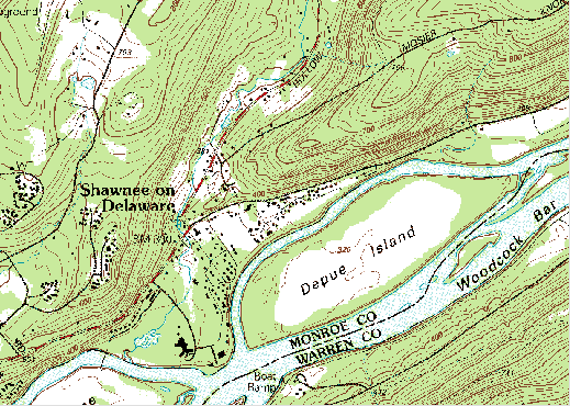
The DRG data correspond with the 7.5 minute quadrangle for Bushkill, PA.
- Notice that as you glide the magnifying glass cursor over the DRG, the UTM (NAD 27) and geographic coordinates of the cursor's position change in the lower right-hand corner of the window. This tells you that the DRG is in fact georeferenced.
- Experiment with Global Mapper’s tools. Use the Zoom and Pan tools to magnify and scroll across the DRG. The Full View button (the one with the house icon) refreshes the initial full view of the data set.
- The Measure tool (ruler icon) allows you to not only measure distance as the crow flies, but also to see the area enclosed by a series of line segments drawn by repeated mouse clicks. Note again the location information that is given to you near the bottom of the application window.
Certain tools, e.g., the 3D Path Profile/Line of Sight tool are not functional in the free (unregistered) version of Global Mapper.
- To view an excerpt from the DRG metadata, navigate to Tools > Control Center, then click the Metadata button.
By 1992, the series of over 53,000 separate quadrangle maps covering the lower 48 states, Hawaii, and U.S. territories at 1:24,000 scale was completed, at an estimated total cost of $2 billion. However, by the end of the century, the average age of 7.5-minute quadrangles was over 20 years, and federal budget appropriations limited revisions to only 1,500 quads a year (Moore, 2000). As landscape change has exceeded revisions in many areas of the U.S., the USGS topographic map series has become legacy data outdated in terms of format as well as content. The paper quad-based topographic map series has been replaced by the National Map program. The National Map is designed to produce a multi-scale digital map for the country; this is discussed in Section 1.3 below. First, we discuss map accuracy, which is a topic that applies to both the legacy paper map products and the new digital products of the National Map.
Try This!
Search the Internet on "USGS topographic maps" to investigate the history and characteristics of USGS topographic maps in greater depth. View preview images, look up publication and revision dates, and order topographic maps at "USGS Store."
8.1.3 Accuracy Standards
Errors and uncertainty are inherent in geographic data. Despite the best efforts of the USGS Mapping Division and its contractors, topographic maps include features that are out of place, features that are named or symbolized incorrectly, and features that are out of date.
The locational accuracy of spatial features encoded in USGS topographic maps and data are guaranteed to conform to National Map Accuracy Standards. The standard for topographic maps states that horizontal positions of 90 percent of the well-defined points tested will occur within 0.02 inches (map distance) of their actual positions (thus, 10% of points can vary by more than this). Similarly, the vertical positions of 90 percent of well-defined points tested are to be true to within one-half of the contour interval. Both standards are scale-dependent. For example, at 1:24,000, 0.02 inches equals 40 feet (thus 90% of points tested at this scale must be within 40 feet of their true location; in contrast, at 1:250,000, the tolerance is 416.7 feet).
Objective standards do not exist for the accuracy of attributes associated with geographic features. Attribute errors certainly do occur, however. A chronicler of the national mapping program (Thompson, 1988, p. 106) recalls a worried user who complained to USGS that "My faith in map accuracy received a jolt when I noted that on the map the borough water reservoir is shown as a sewage treatment plant."
The passage of time is perhaps the most troublesome source of errors on topographic maps. As mentioned in the previous page, the average age of the original USGS topographic map series was over 20 years at the turn of the century when the decision was made to stop updating maps on a quad-by-quad basis. Geographic data quickly lose value (except for historical analyses) unless they are continually revised. The sequence of map fragments below shows how frequently revisions were required between 1949 and 1973 for the quad that covers Key Largo, Florida. Revisions are based primarily on geographic data produced by aerial photography.
Try This!
Investigate standards for data quality and other characteristics of U.S. national map data at Standards and Specifications or by searching the Internet for "usgs national map accuracy standards"
8.1.4 USGS National Map
Executive Order 12906 decreed that a designee of the Secretary of the Department of Interior would chair the Federal Geographic Data Committee. The USGS, an agency of the Department of Interior, has lead responsibility for three of the seven National Spatial Data Infrastructure (NSDI) framework themes--orthoimagery, elevation, and hydrography, and secondary responsibility for several others. In 2001, USGS announced its vision of a National Map that "aligns with the goals of, and is one of several USGS activities that contribute to, the National Spatial Data Infrastructure" (USGS, 2001, p. 31). A 2002 report of the National Research Council identified the National Map as the most important initiative of USGS’ Geography Discipline at the USGS (NRC, 2002). Recognizing its unifying role across science disciplines, USGS moved management responsibility for the National Map from Geography to the USGS Geospatial Information Office in 2004. (One reason that the term "geospatial" is used at USGS and elsewhere is to avoid association of GIS with a particular discipline, i.e., Geography.) In 2001, USGS envisioned the National Map as the nation’s topographic map for the 21st Century (USGS, 2001, p.1). According to Characteristics of the National Map (USGS, 2001, p. 11-13), improvements over the original topographic map series were to include:
- Currentness
Content will be updated on the basis of changes in the landscape instead of the cyclical inspection and revisions cycles now in use [for printed topographic map series]. The ultimate goal is that new content be incorporated within seven days of a change in the landscape. - Seamlessness
Features will be represented in their entirety and not interrupted by arbitrary edges, such as 7.5-minute map boundaries. - Consistent classification
Types of features, such as "road" and "lake/pond," will be identified in the same way throughout the nation. - Variable resolution
Data resolution, or pixel size, may vary among imagery of urban, rural, and wilderness areas. The resolution of elevation data may be finer for flood plain, coastal, and other areas of low relief than for areas of high relief. - Completeness
Data content will include all mappable features (as defined by the applicable content standards for each data theme and source). - Consistency and integration
Content will be delineated geographically (that is, in its true ground position within the applicable accuracy limit) to ensure logical consistency between related features. For example, ... streams and rivers [should] consistently flow downhill... - Variable positional accuracy
The minimum positional accuracy will be that of the current primary topographic map series for an area. Actual positional accuracy will be reported in conformance with the Federal Geographic Data Committee’s Geospatial Positioning Accuracy Standard. - Spatial reference systems
Tools will be provided to integrate data that are mapped using different datums and referenced to different coordinates systems, and to reproject data to meet user requirements. - Standardized content
...will conform to appropriate Federal Geographic Data Committee, other national, and/or international standards. - Metadata
At a minimum, metadata will meet Federal Geographic Data Committee standards to document ... [data] lineage, positional and attribute accuracy, completeness, and consistency.
As of 2012, USGS’ ambitious vision has not yet been fully realized. Insofar as it depends upon cooperation by many federal, state, and local government agencies, the vision may never be fully achieved. Still, elements of a National Map do exist, including national data themes, data access and dissemination technologies such as the Geospatial One Stop portal (GeoPortal) and the National Map Viewer, and the U.S. National Atlas. A new Center of Excellence for Geospatial Information Science (CEGIS) was established in 2006 under the USGS Geospatial Information Office to undertake the basic GIScience research needed to devise and implement advanced tools that will make the National Map more valuable to end users. The data themes included in the National Map are shown in table 8.1.
| -- | National Map Themes | NSDI framework themes |
|---|---|---|
| Geodetic control | No | Yes |
| Orthoimagery | Yes | Yes |
| Land Cover | Yes | No |
| Elevation | Yes | Yes |
| Transportation | Yes | Yes |
| Hydrography | Yes | Yes |
| Boundaries | Yes | Yes |
| Structures | Yes | No |
| Cadastral | No | Yes |
| Geographic Names | Yes | No |
To Watch
The status of the effort as of fall, 2012 is detailed in this US Topo video:
PRESENTER: Our greatest resource to understanding our geography has always been maps. Sprawling urban areas, growing infrastructure, and changing shorelines drive the need for up-to-date maps and geographic data.
MICHAEL COOLEY: Topographic maps have been used by outdoor enthusiasts, land planners, land managers, emergency response. They've used these maps and depended on them for decades.
PRESENTER: Today, the US Topo, a product of the national map, brings a new way of looking at maps.
WILLIAM SCHOUVILLER: For me, the US Topo is different from the commercially available maps and their viewers due to its precision.
CYNTHIA BREWER: US Topo is trusted; the content is the primary source of publicly available geographic data.
CHARLES DULL: The US Topo can be provided in a digital format or it can be used as a hard copy.
MICHAEL COOLEY: The US Geological Survey has a long history of topographic mapping.
PRESENTER: From 1947 to 1992, the USGS created over 55,000 7.5 minute quadrangle maps for the lower United States and periodically revised them.
MICHAEL COOLEY: The National Geospatial Program is responsible for mapping the nation. Mapping our nation is a very labor intensive process. USGS is embracing new technologies to continue our high standards of quality while improving efficiencies and lowering cost.
PRESENTER: We have seamlessly combined a traditional look and feel with new features to provide greater value to the user.
CYNTHIA BREWER: The use of imagery adds a new dimension to map reading and interpretation. It lets you bring in a layer with up-to-date conditions so that you can superimpose or interleave with existing data, and understand changes in the landscape. Imagery introduces unique map design issues. Multi-scale onscreen is quite different than designing for a printed map. At Penn State University, students and researchers are doing some groundbreaking work with USGS to make the very best cartographic designs for US Topo.
WILLIAM SCHOUVILLER: US Marine Corp's integral part of the Homeland defense the first responder community. In our opinion, it's critical that the US Topo be updated every three years to provide that base map for response to natural and man made disasters. The ability to download maps to our laptop, computers, and handheld devices allows us to deploy in a matter of hours as opposed to days. This help save lives of both the victims as well as the first responders.
CHARLES DULL: The US Forest Service and USGS have been working together dating back to the 1920s when we first began producing topographic maps of our nation's national forest and grasslands. Today, we're working together to produce US Topo-- a product that covers 193 million acres of national forest and grasslands. US Forest Service collects information on forest service roads, boundaries, geographic names, elevation, and we provide that information to the USGS. And they produce the US Topo.
MICHAEL COOLEY: We do customer surveys of key mapping communities. This feedback and ongoing communication with our users guides us to improving the US Topo.
CYNTHIA BREWER: The look of US Topo is like the traditional paper USGS maps, and I think that's really going to improve over time as new features are added and the design is refined.
WILLIAM SCHOUVILLER: The idea that every feature naturally has a precise location to it so that I can find that feature on the ground later is very important. We use the National Grid System. That's a locational-based system used in the US Topo to allow first responder to find locations when those standard locations do, such as street signs or landmarks, are missing.
CHARLES DULL: It's a great example of our two agencies working together to meet our missions of forest service to protect and manage the nation's national resources, and the USGS and their production of the national map.
LAURIE JASSO: Here the USGS store, or National Map Viewer, tens of thousands of US topo maps per year are downloaded for free by users. Once downloaded, these high quality maps can be printed to scale.
PRESENTER: Our vision does not end there. Taking maps into the digital realm is an evolution.
MICHAEL COOLEY: We continually assess and look to add data for Alaska, Hawaii, and the Pacific Territories. As US Topo evolves, we'll be updating and adding new features. The potential of these maps is far reaching.
PRESENTER: The incorporation of additional data layers offers exciting new possibilities to explore and understand changes in our landscape.
MICHAEL COOLEY: We understand the importance of a robust map. And we are incorporating additional data layers from the national map.
WILLIAM SCHOUVILLER: As we start adding specific features and specific buildings in, such as police stations, and hospitals, schools, it will be a critical tool for that first responder.
CYNTHIA BREWER: US Topo is the first step in electronic national topographic map for the future. The national map data that are used to build the US Topo maps are available for a public download. And that's a powerful benefit.
PRESENTER: Visit www.nationalmap.gov to see how you can partner with us for the future.
In the following sections of this chapter, we will describe in more detail about how Earth’s surfaces are derived and represented on maps.
Practice Quiz
Registered Penn State students should return now take the self-assessment quiz about Topographic Maps.
You may take practice quizzes as many times as you wish. They are not scored and do not affect your grade in any way.