Lesson Data
This section provides links to download the Lesson 3 data and reference information about each dataset (metadata). Briefly review the information below so you have a general idea of the data we will use in this lesson. You do not need to click on any of the hyperlinks as we will do this in the Step-by-Step Activities.
In this lesson, we will experiment with two different types of data providers, both public and private. For the publicly available data, we will use a combination of online data services and raw GIS files, which you will have to download yourself. The private data is included in the zip file below.
Keep in mind, the websites and servers of public data providers may occasionally experience technical difficulties. If you happen to work on this lesson while one of the sites is down, you may need to stop work and start the following day again to allow time for the servers to reboot.
Lesson 3 Data Download:
Note: You should not complete this activity until you have read through all of the pages in Lesson 3. See the Lesson 3 Checklist for further information.
Create a new folder in your GEOG487 folder called "L3." Download a zip file of the Lesson 3 Data and save it in your "L3" folder. Extract the zip file and view the contents. Information about all datasets used in the lesson is provided below:
Metadata
Publicly Available Data:
Base Map:
- Source: ArcGIS Online
- Service Name: OpenStreetMap
- Within ArcGIS Pro, go to Map tab, Layer group, Basemap.
USDA Farm Service Agency - National Agricultural Imagery Program (NAIP):
- Source: National Agriculture Imagery Program (NAIP), ArcGIS Online
- Service Type: Web Map Service (WMS)
- Service Name: USA NAIP Imagery (2018)
- Metadata: NAIP Imagery
Boundaries of Fish & Wildlife Service Lands:
- Source: ArcGIS Online
- Service Type: Feature Service
- Service Name: U.S. Fish & Wildlife Service Lands
- Sub Layer: FWS Boundaries
- Metadata: U.S. Fish and Wildlife Service Lands
National Wetlands Inventory: The U.S. Fish and Wildlife Service National Wetlands Inventory classifies wetlands into 5 major ecological types, subdivided into numerous categories.
- Online viewer (Wetlands Mapper)
- Web Map Service
- Download Raw data
- Instructions on how to connect to NWI Web Services
- Metadata: National Spatial Data Infrastructure - Wetlands Layer, National Spatial Data Infrastructure Wetlands Layer
Great Lakes Coastal Wetland Inventory: Detailed wetlands inventory of the Great Lakes Region developed through the Great Lakes Coastal Wetland Consortium.
- File Name: glcwc_cwi_polygon.zip (12.46 MB) In addition to the Coastal Wetlands Inventory shapefile that you are downloading, embedded in the shapefile is its metadata (Data type: XML Document). This metadata, along with the full publication below, will help you to understand the classification system developed for the Great Lakes wetlands and how they can be applied to your analyses and planning. ** They will also help you to answer a quiz question or two.
- GLCWC Website
- GLCWC Metadata, Full Publication (enhanced metadata)
Private Data (Located Inside the Lesson 3 Folder):
- Study_Site: The study site boundary represents the wetland areas within Ottawa National Wildlife Refuge that are hydraulically connected to Lake Erie. The file is included in two formats - .shp and .kmz.
- Time Series Imagery: The images show the land cover in the study area at three different points in time. (The study site and historic imagery files are bundled in a file called a map package).
- Time Series Wetland Vegetation: This data was created as part of a research project entitled, “Coastal Wetland Habitat Restoration and Exploration.” Special thanks to Kurt Kowalski from the United States Geological Survey for allowing us to share this data with the class. The data was created by digitizing and classifying wetland vegetation from a series of historical aerial photos. There is one shapefile per study year. The smallest polygon digitized (minimum mapping unit) is 0.25 hectares. To save time, we will only explore 3 out of the 5 available time periods: 1962, 1973, and 2005. You have the option to explore the 1939 and 1950 data in the Advanced Activities section. We will look at some of the actual imagery used to create the data in the Step-by-Step Activity. These image dates and sources are shown in Figure 4, below.
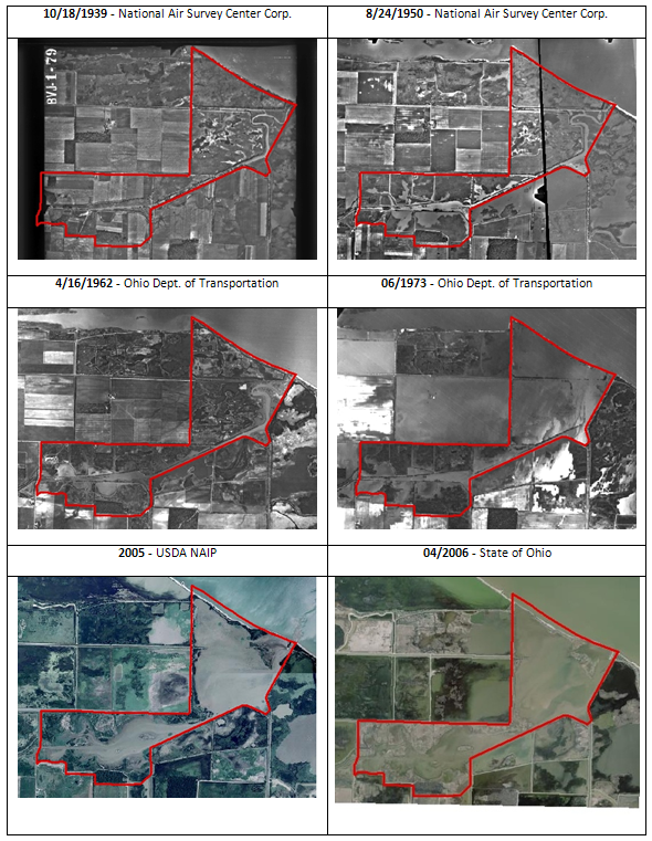 Figure 4: Historical time-series aerial photos of the study site between 1939 and 2006. All images except the 2005 & 2006 images are the original source images used to digitize the vegetation shapefiles used in this lesson.© Kurt Kowalski, USGS. Used with permission.