Gists
While all free GitHub accounts are required to publish public repositories, all accounts have the ability to create Gists. Gists are single page repositories in GitHub, so they don't support projects with folder structures or multiple files. Since Gists are a single page repository, they are good for storing code snippets or one page projects. Gists can be public or private, even with a free account.
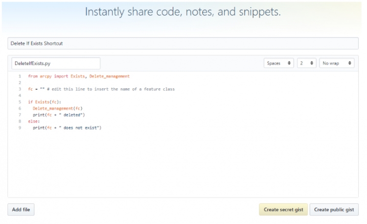
To create a Gist in GitHub, log into GitHub and then click on the plus sign in the upper right hand corner. In the options presented, choose "New gist." Enter a description of the Gist (in figure 1.30 "Delete if Exists Shortcut" is the description) as well as the filename with extension (in figure 1.30 this is DeleteIfExists.py). Enter code or notes in the large portion of the screen or import the code by using the "Add File" button. You have two options for saving your Gist- either "Create secret gist" or "Create public gist."
"Secret" Gists are only mostly secret since they use the internet philosophy of difficult-to-guess urls. If you create a secret Gist, you can still share the Gist with anyone by sending them the url, but there are no logins required to view the Gist. Along this same philosophy, if someone stumbles across the url, they will be able to see the Gist.
For more information about Gists, see the official GitHub documentation at "About Gists" page on Github's website.
GeoJson
For GIS professionals, Gists are additionally useful since a Gist can be a single GeoJson file. GeoJson files are essentially a text version of geographic data in json formatting. Other developers can instantly access your GeoJson data and incorporate it from GitHub into their online mapping applications without needing to get a hard copy of the shapefile or geodatabase feature class or rely on some kind of map server. GitHub will automatically display GeoJson files as a map whether the file is a Gist or a part of a larger repository. For example, take a look at GitHub's lyzidiamond/learn-geojson page. At first, you’ll see the GeoJson file interpreted as a map. If you click the “Raw” button located on the upper right-ish side of the map, you will see what the GeoJson file looks like in text form. GeoJson can be easily used in Python since after reading in the file, Python can work with the text as if it is one giant dictionary.