Introduction:
National borders often shift over time, in response to a variety of different motivations, including military conquest, quest for resources, and resolving conflicts. At times, the borders that are delineated are not representative of the populations that reside in the areas being partitioned. This is true with regards to the present-day borders in the Middle East and the movement to develop a Kurdish State: Kurdistan.
Overall Task:
Individually, you will read the provided resources and assess the data provided to you in the ArcGIS Online Group for this class. You will then delineate borders to the best of your ability to create a Kurdistan that would cause the least amount of conflict.
After completing this task individually, you will share your borders with your small group, and together you must negotiate amongst yourselves to develop borders for Kurdistan that each group member agrees with. When the group map is finished, the group members will work together to answer the four questions at the end of the exercise.
Understanding the History:
Why do the Kurdish populations want a sovereign state? To understand the answer to this question, you need to dive into the group’s history. This stateless nation shares an identity and language that dates back to the Middle Ages, even though some Kurds differ in terms of their religious beliefs (Blakemore 2019). We will not deep-dive into the history of the Kurds too far, but understand that they share an ethnic identity that ties them, which feeds their desire for their own sovereign state.
To understand more about what happened, please read the following article about the Sykes-Picot Agreement and its lasting impacts on the Middle East, especially with regards to its impact on the Kurdish population.
The splitting of the formerly continuous Kurdish population amongst several countries has been seen as problematic. This minority population within several countries (including Turkey, Iraq, Syria, and Iran) have often faced difficulties in expressing their cultural identity. There have often been conflicts within Turkey, Iraq, Syria, and Iran with regards to the Kurdish populations. Please view the following video to help demonstrate some of the conflicts within Turkey, Iraq, and Syria.
Investigating Previous Proposals for the Kurdistan State and Ethnic Boundaries:
While Kurdistan has never actually been formalized as a nation, the geographic expanse of Kurdish populations has ebbed and flowed over time, as do many other ethnic groups. If you’re interested in the various changes to this ethnic population over time, consider viewing the following website (note that you are not required to view the site in order to complete the exercise):
-
The Kurdish Question on the Map (This website, while potentially biased, also provides some context for the delineation of Kurdistan.)
While this website goes into greater depth, this exercise will focus on the delineation of a potential present day Kurdistan. Understanding the people’s history is integral to this delineation, and this exercise will have you compare the Kurdistan delineation proposed in 1920, the Kurdistan delineation proposed in 1945, and the currently-understood geographic spread of areas that are predominantly ethnically Kurdish.
Reference:
Blakemore, E. (2019, August 16). Today, the Kurds are spread across four nations. Who are they? National Geographic.
Task 1:
Compare the Kurdistan delineation proposed in 1920, the Kurdistan delineation proposed in 1945, and the currently-understood geographic spread of areas that are predominantly ethnically Kurdish.
- Using your Penn State credentials, sign into ArcGIS online, and open a new Map viewer.
- Add the following Layers to your map:
- Lesson 4: Kurdistan_1920
- Lesson 4: Kurdistan_1945
- Ethnicity_Middle East
- For the proposed boundaries for Kurdistan in 1920 and 1945, change the colors to something that is easy to compare, and adjust the transparencies. Refer to Lesson 1’s exercise if you need a refresher on how to do this.
- For the Ethnicity_Middle East layer, we want to extract out the Kurdish areas:
- Click on the layer in the contents pane on the left to activate the right-side options.
- Select “Filter” or click the funnel button:

- Click “+ Add Expression”
- Set your expression as follows:
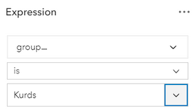
- To do this you will have to replace “statename” with the “group_” field. Then, select “Replace.”
- Then type “Kurds” in the next dialog.
- Before clicking “Save,” note that the area delineating the “Kurds” is a different color than the other ethnicities. Take a moment to click the area where the “Kurds” ethnicity is located. A pop-up will generate, and depending on where you click, there may be multiple options:
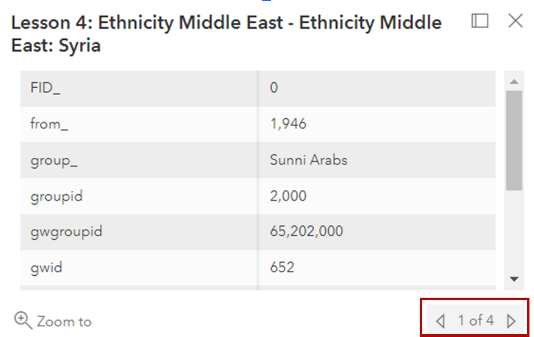
Click the arrows to the right and left at the bottom right of the dialog to determine which ethnic groups are collocated with the Kurds in these areas. (Keep this in mind when you're delineating your boundaries — just because there are areas of Kurdish minorities does not mean there are no other ethnic groups in that area as well.) - Click “Save” at the bottom of the expression pane. Your map should now only display the areas delineated as Kurds.
- Using what you learned in Lesson 1, change the color and transparency to make it easier to compare to the other layers.
Recommendation:
Play with the order of the layers in your map. If one of the smaller areas is “on top” of a larger area, consider changing the layer order by clicking on the layer, holding the left click button, and dragging it to the top.
Questions to consider:
- How do the 1920 proposed boundaries compare to those proposed at the 1945 Conference of San Francisco? What do you think impacted the change in the proposed boundaries?
- How do these proposed boundaries compare to the geographic distribution of predominantly Kurd areas?
Task 2:
Delineating boundaries for a new country is often rife with controversy. To create a new country means taking territory from existing countries, which many countries do not take kindly to. Thus, as described in the Lesson 4 content, the delineation of borders is delicate business, and many considerations must be made before lines are drawn. Will the delineations be adequate for the country being created? Will it mitigate any potential conflicts with countries that territory will be taken from? What concessions can be made to the countries losing territory?
This is your task: taking into account what you know about the region, the Kurds, and the surrounding countries, delineate the borders for Kurdistan.
Recommendations:
- In addition, you may want to add another copy of the Ethnicity layer to your map. This may help you in delineating your boundaries and taking into account areas where there are multiple ethnic groups, not just the "Kurd" ethnicity.
- Take into account not just what the Kurds want, but also consider some of the geopolitical complexities you learned about in the first part of the exercise.
Steps:
- In your ArcGIS online map, add your personal Kurdistan delineation Feature Layer. This layer will say “Kurdistan_[insert your last name here].” Please only use the one that has your last name. If you do not see one that has your last name, please let your instructor know, so they can create a Feature Layer for you. This is the layer you will edit.
- Make sure to click on your Kurdistan layer to activate the tools associated with it. If your right-side toolbar is collapsed, click the two carrots on the bottom right to open the menu.

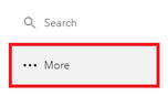
- Under the “Search” option, please select “More.”
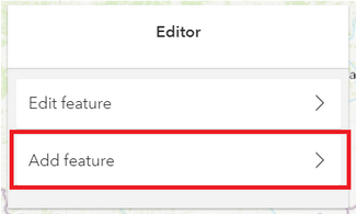
- Select “Edit.”
- The editor toolbar will appear, with two options: Edit Feature or Add Feature. You want to “Add Feature.” Please click on “Add feature.”
- Follow the prompts in the dialog and begin drawing your boundaries for Kurdistan.
- Double Click when you’re finished.
- It will ask you for an “ID” attribute. Please enter any integer (non-decimal) number.
- Be sure to save your changes using the left-hand menu. If your menu is collapsed, please click the carrots on the bottom left of the menu (just as on the right-hand menu) to expand your options. Click “Save and Open” and save your map.
Questions:
- What considerations did you make in the delineation of these borders? Why did you draw them the way you did?
- What potential conflicts do you foresee in the delineation of your borders? If you were negotiating these borders, how would you mollify these conflicts?
Group Task:
Once you’ve created your individual delineations, post them to your group’s discussion board. Come together, discuss the differences between your delineations, and create one delineation that you all can agree on.
Following the same procedure you did for your individual exercise, use your group’s Kurdistan feature layer (Named: Kurdistan_Group[your group’s number]) to delineate your agreed upon borders.
Group Questions:
- How different were the borders amongst the group?
- How did your group resolve differences if they existed?
- How did your group rationalize your choices with regard to the new borders, individually and collectively?
- What factors did your group prioritize in determining where to set the borders?
Deliverable:
When you have completed the tasks 1 and 2, you should work with your group members to complete the Group Task and answer the Group Questions above. The final submission for this assignment should include the following:
- A screen capture of the group's final map.
- Answers to the Group Questions.
- I am expecting just a paragraph or two to answer each question.
- A description of the division of labor for the assignment including member names and tasks.
When you have completed the assignment, select one group member to submit your document to the Lesson 4 ArcGIS Online Group Exercise dropbox.
The assignment should be submitted to the Lesson 4 ArcGIS Online Group Exercise dropbox, which contains specific instructions for submitting the assignment. I am expecting just one submission per group.
Please check the Canvas Syllabus or Calendar for specific time frames and due dates.