Lesson 1: Introduction to Location Intelligence
1.0 Introduction to Lesson 1
Welcome to Lesson 1 and a quick overview of what you should expect in each lesson.
- There will be a brief Introduction to the Lesson, a list of Goals, a checklist of Activities for the week, along with Deliverables and Due Dates.
- "Post comment," found in the "Where to Complete" column, refers to your post in the Canvas Lesson Discussion Forum.
- You may find it convenient to print this page so you keep on schedule.
Please notice that Deliverables are due Tuesday nights (midnight State College time). This will help keep the discussions timely, lively, and meaningful.
Do not hesitate to contact me if you are having difficulty navigating the system. Also, please alert me if any links are not working or if text needs fixing.
Instill in yourself - and practice frequently - an addage from the FranklinCovey group to "Begin [each day, assignments, GEOG 850 Lessons] with the end in mind". Please read the Coda (pp.133-137) in Geography, Why It Matters by Alexander B. Murphy. The author highlights the importance of learning geography to understand changes in the world around us (2018: p.134):
We are awash in data about the transformations taking place, but we cannot hope to gain a handle on them if the population at large has little sense of Earth's geographical character and the changes that are happening to it; if students and scholars lack the analytical perspectives and tools needed to assess the evolving spatial organization and material character of places and regions; or if policy-makers and planners are not equipped to think geographically about issues and problems - to think knowledgeably and critically about geographical patterns, to consider why things happen where they do, and to appreciate how geographical context influences what happens.
On March 23, 2021, a massive container ship, Ever Given, ran aground blocking the Suez Canal. Work immediately began with every tugboat nearby to attempt to free the ship and minimize the impact on shipping traffic in the Suez Canal. At that time, little did the public know that this event would have a global impact on supply chains, sea traffic management, and disrupting deliveries of most industries. BBC News. (2021). How many people knew the location of the Suez Canal? How many people learned new geospatial information of global ship traffic from this grounding event? Suez Canal: Wedged container ship seen in busy waterway. 24 Mar 2021 [1].

Learning Objectives
At the successful completion of Lesson 1, you should be able to:
- provide examples of the use of location intelligence, GIS, and geography in business strategy/decision-making;
- identify principles of competition and the roots of business problems;
- discuss the principles of intelligence analysis;
- introduce location intelligence as a process for geospatial analysis of business problems;
- discuss the term project.
What is due for Lesson 1?
Lesson 1 will take us one week to complete. There are a number of required activities in this lesson. For assignment details, refer to the table below.
Note: Please refer to the Calendar in Canvas for specific time frames and due dates.
| 1.1 Introduction to Location Intelligence | ||
|---|---|---|
| Requirements | Details | Access / Directions |
| Read | Read the course content. | Use the Lessons menu or links below to continue moving through the lesson material. |
| Murphy: Geography, Why It Matters, Coda (pp.133-137) | The Geography: Why it Matters reading is from the required textbook for this course. | |
| Why Where Matters, Companies Ask Geospatial Questions | Registered students can access the reading in Canvas on the Lesson 1 Readings page | |
| Deliverable | Discussion comment on Video, Due Tuesday. | Post in Canvas to the Lesson 1.1 - Location Analysis Video forum. |
| 1.2 Location-based Business Problems | ||
|---|---|---|
| Requirements | Details | Access / Directions |
| Read | Read the course content. | Use the Lessons menu or links below to continue moving through the lesson material. |
| When it Comes to Analytics Success, X Marks the Spot | Registered students can access the reading in Canvas on the Lesson 1 Readings page. | |
| Deliverable | No Deliverable | N/A |
| 1.3 Intelligence Analysis Principles | ||
|---|---|---|
| Requirements | Details | Access / Directions |
| Read | Read the course content. | Use the Lessons menu or links below to continue moving through the lesson material. |
| First Principles of Intelligence Analysis | Registered students can access the reading in Canvas on the Lesson 1 Readings page. | |
| Deliverable | No Deliverable | N/A |
| 1.4 Location Intelligence | ||
|---|---|---|
| Requirements | Details | Access / Directions |
| Read | Read the course content. | Use the Lessons menu or links below to continue moving through the lesson material. |
| Read | Murphy: Geography, Why It Matters, Ch. 1 (pp. 1-30) | The Geography: Why it Matters reading is from the required textbook for this course. |
| Deliverable | Post your comments on the definition of Location Intelligence, Due Tuesday. | Post in Canvas on the Lesson 1.4 - Location Intelligence Definition forum. |
| 1.5 Term Project Overview and Weekly Deliverables | ||
|---|---|---|
| Requirements | Details | Access / Directions |
| Read | Read through Term Project Overview. | Post any Questions to Canvas Term Project module - Term Project Discussion forum. |
| Deliverable | No Deliverable | N/A |
Questions?
If you have any questions about course mechanics, where to do something, or how to do something, feel free to send me an email via the Canvas system at any time.
1.1 Introduction to Location Intelligence
Today’s location-based situations or problems are complex and the information decision makers need is often obscured in their organization’s Big Data. There may be a quick, apparent solution found in an organization’s operating agreement, checklists, or previous decisions. Yet, tough business problems benefit from a systematic approach.
Location intelligence starts with a question. What location-based challenge or opportunity is my organization trying to solve? An American inventor and businessman, Charles Kettering, may have been the first to note that a problem clearly stated is a problem already half solved. Most business data connects physical locations, dates, and times—linking business operations to place and time.
Geospatial analysts ground themselves in the problem. Then, through effective research and applications of geospatial science, analysts uncover patterns in data that link observations, hypotheses, and information to a solution. Understanding a scientific method of study or workflow method of analysis is foundational to examining and solving complex problems.
GEOG 850 focuses activities on location intelligence for business, dealing with sectors of an economy, business principles, location-based problem solving, risk assessment, and digital technology to enhance location analytics. This is not just about omni-channel marketing using smart phones. So, throughout the course reflect on how the process, technology, and output of location intelligence apply to all facets of business, e.g. developing strategies, local to global operations, manufacturing, even recycling and waste management, sales force alignments, and communications.
In a 2010 text Why 'Where' Matters: Understanding and Profiting from GPS, GIS, and Remote Sensing, Bob Ryerson and Stan Aronoff, welcome readers to the new economic era - the GeoEconomy.
The GeoEconomy is how we define the economy that is increasingly being driven by, and dependent on, geospatial or geographic information - inofrmation that is tied to or linked to a geographic location. This location based information is termed geospatial or geographic information or geo-information. In some significant ways the GeoEconomy is a throw-back to prehistoric time when individual and societal survival depended on them having a thorough understanding of the geography of the places in which they lived. However, in the past much of the geographic advantage was based on what we call geo-luck - those in ancient times that happened to have the advantage of being located close to water and good soil, or who had an easily defended home were lucky - those that did not, died or lived so close to the subsistence level that they could not develop more advanced civilizations.
Simply put: today those who "get it," those who understand the GeoEconomy and how to use it to their advantage, will do well. Those who do not will, as our ancestors did, depend on geo-luck. Luck, geo or otherwise, like hope, is not a strategy.
However, today individuals, businesses, and governments at all levels can now make geodecisions based on better information that is more easily accessible than at any time in history. Not only do we all have access to the data, we also have ready access to low or no cost tools that enable the non-specialist to use that data. Anyone capable of accessing and using the Intenet can access and use geospatial information relevant to themselves, their community, business, country, or the global environment.
The authors outline a series of typical business questions corporations will ask relating location, geospatial technology, and information. Geospatial data scientists follow the scientific process and organized analysis methods to prepare geospatial data for use in business decision making. Reflexive inspection of an organization offers an insight to business questions from many categories to include marketing, resource management, consulting, or risk management. The objective of this course is to teach and reinforce critical thinking in geospatial business contexts; not to train graduate students on a particular location intelligence platform.
Contemporary professional journals include new references of location intelligence using various types of information and analysis methods, e.g. crowdsourcing, human geography, visual analystics, forecasting, geospatial modeling, risk assessment, sustainability, and decision making. As an introduction to Location Intelligence for Business, we offer an insight to business sectors and career fields relating to Location Intelligence:
- Geospatial Intelligence (GEOINT)
- Geo-Marketing
- Urban Planning
- Environmental Concerns and Sustainability
- Cartography and Webmap Design
- Real Estate Management
- Remote Sensing
- Business Analysis
- Consumer to Customer Digital Transformation
Former Penn State student—now instructor—Rob Williams shares his Capstone work. Enjoy and process the presentation.
Hi, I'm Rob Williams from Penn State. I'm going to demonstrate how to use geospatial intelligence for a business problem. In this case, where to locate a new metropolitan airfield where we want it, say near a business center, and not where the airports are today. So the analytical problem is, what's the location within an urban area to put a new air service that doesn't need a runway? And I'll talk about that runway in a second. But as I looked through this problem, I discovered that I had to amend the problem statement. Instead of location, I really need to address places. And the place includes where are the people, what are they doing, what's happening in that region? And not just the downtown urban area, but the entire metropolitan region. I also saw that looking at airline service was too narrow. And what really is important is the entire air transportation system, both the private sector and the public sector, and this is now our problem. So what are these aircraft that we're talking about? These are vertical takeoff and landing aircraft. The ones on the left, you can see, are familiar to us. Traditional helicopters, either the small executive class or the larger transport class for people or cargo. And there's a new class of aircraft that could be coming in the future, tilt rotors, which take off and land like a helicopter vertically. But as you can see in the upper picture, the rotors tilt forward and the airplane can fly like a commuter at high speeds. So the opportunity here is, where can we locate these vertical take off and landing aircraft, in urban areas, that adds to the economic wealth of an area? These could be either in downtown areas like the Manhattan heliport you see in the center or maybe out on a ring-road like the Hotel Vertiport located on the right. We're going to look at the benefits to the economic development both from the traveler's standpoint as well as the community and the economic benefits. There's also costs for this kind of service, either environmental, noise, safety, and the cost of infrastructure. But for this particular problem, we're only going to focus on the benefits, using our GIS methods. The value then would be what's the value to a traveler, either by shortening their travel distance on the ground, making it more convenient, there's also benefits to the business trade areas, and finally, the overall economic activity. These can all be evaluated using Geospatial Intelligence methods. The specific methods we use are business location analytics and network analysis. A tool suite which is good for this purpose would be ESRI's Business Analyst Online, and they also happen to provide a lot of the data. I'm going to speak specifically about this very interesting set called Tapestry. So the overall approach is three steps. We're going to look at a sample metropolitan area. We're going to do a coarse evaluation to figure out where in that metropolitan area might we want to locate such an airfield, and we do use this through either direct measurements of data or maybe proxies, we'll create the data layer maps, and then pick a general target area. And then, finally, using fine tune analysis, we'll look at the benefits of specific spots on the ground, specific places, and determine which is the best. So, to start off, the sample market I was looking for: a urban area, with a single airport, that had lots of good data about the demographics. I selected the Philadelphia region for this purpose. So, in the Philadelphia area, one of the first things we can evaluate is who travels by air? ESRI and the online system has a data set for exactly this. Who has traveled more than three times in the last 12 months? And it's divided by zip code. So, here you can see in the green spaces, households by zip code that have traveled three times or more in the last year. Philadelphia airport is at the airplane icon in the center, so you can see north and west of the city is a large density of travelers and then to the far northeast up near the Trenton area, you can see another center. We're going to focus on this area north and west of Philadelphia Airport. To do this, I'm going to use the Tapestry data set. This is a really interesting dataset that looks at demographics, population, wealth, income, types of jobs, types of mobility, residences, and, in particular, this group called the affluent estates on the left. This is the wealthiest group, and the premise is that these folks probably do the most travel and would be most interested in having this kind of service available to them. So, looking again at that map of Philadelphia with Philadelphia spotted in the center. Again, north and west of the city, in red, in that circle, you see zip codes in red that have the highest density of the affluent estates residents. So that is an initial indicator. Second, I also looked at US census data, the NAIC code for finance and industry or insurance industry, and you can see in that same region, just a sample, but you can see how dense that same area is for these kind of businesses. So, this area north and west of Philadelphia airport looks like a good place to look more closely. So, as we hone in, I picked one spot in the center of that region. And now, it's a question of where to put that first initial look. I'm looking for, in particular, short driving times, ten to fifteen, ten minutes or so, and, in particular, I'm looking at who lives in this region? What kind of residents? The blue and the yellow colored regions are the highly mobile people in the Uptown Individuals and GenXurban from the tapestry data set. They would probably be most interested in having this kind of air mobility right in their neighborhood. But more interesting is the green and the orange segments in the surrounding areas. These are the folks who have, say ten to twenty minute drive times to such a location. And this is the population we're very interested in. So, MIT did a study on which industries have the highest propensity for air travel compared to trains, compared to automobile. And, you can see the industries here that use the air transportation the most. So, now that we have identified these industries, we can use US Census Data, the North American Industry Classification System to actually identify on maps where these folks and businesses live. So, wholesale trade, finance and insurance, and professional services, we'll focus on those three. In the first case, wholesale trade, you can see in three different maps whether the number of businesses, the number of employees, or sales by ZIP code, you can see this concentration around that blue dot that we selected for this study of where to site a new airfield. This looks like a nice concentration right exactly where we placed our marker. In the next industry, finance and insurance, again we see the same pattern. Number of businesses and employees. This again looks like a good segment. Finally, we verify it. A third segment, professional services. This looks like a good pattern. So, we're happy with where that dot is located. We're going to now look more in detail. So, three sites were selected for detailed analysis. These are three areas that are available for development. They're all in that same general area, but which one is the best? So Riverside, King of Prussia, Norristown. We're looking again; these are all three far from the Philadelphia airport. But we're going to look at these 20 minute drive times. If we go back to the tapestry data, there's a different look at the same population, and it's called the urbanization groups. And these are the concentrations that we're looking for. Where is the densest groupings for the same US populations? We already identified the affluent estates. So, this is one group, but they may not be the only group we're looking for. There's also people who are upwardly mobile, who are going to want to travel, who are rising in their careers, these folks too would want to be located near this kind of air facility. So we're going to look at these population groups in the tapestry. So for a specific analysis, we're looking at 10, 20 and 30 minute drive times. From either the Philadelphia airport or these three possible airfield sites. And as you can see in the 20 minute drive time, both the riverside and the King of Prussia look like they have the best collection from these population groups. The 30 minute drive time, you have over 100,000 households that are possible users of this air facility. You'll also notice that Philadelphia Airport increases as well, but my belief is that those people actually live in a different side, perhaps down in the Delaware and the New Jersey region. So I think these three sites are still very good. So then, the final analysis, we see the 20 minute drive time, and of all the different demographic groups, it seems like the majority align best with the King of Prussia site as having the largest numbers at the shortest driving times. So, I think the King of Prussia site is going to be our choice. So, in conclusion. Using the Geographic intelligence analytic methods seems to be a very good way to analyze this particular problem. We used a sense of place, meaning what's the travel propensity and the household incomes and the types of travelers. Seems to be adequately covered. The coarse site selection yielded our general location of where we wanted to site the airfield, and then the fine analysis, we actually could figure out exactly where we want the locations and what is the best site. Thank you.
Read:
- Ryerson, et. al., Why Where Matters, p. 274.
- Questions Companies May Answer with Geospatial Information and Technology
Note: Readings can be found in the Canvas on the Lesson 1 Readings page. This reading applies to geospatial analysis and your Term Project. Throughout the course, you're asked to examine a geospatial/location problem, translate this into an analytic question, and design a workflow to offer solutions to the problem.
As you watch the video and read the selections, consider the following questions:
- Video: What surprised you about the Capstone video?
- Video: What did you take away from the presentation?
- Video: Can you outline the process in as few key steps as possible?
- Lesson: Regarding Ryerson's list on p. 274, "Questions Companies May Answer ..."
Deliverable:
Upon completion of the readings, post 2 comments to the Lesson 1.1 Discussion Forum in Canvas,
Step 1: Read the threads already posted.
Step 2: Pick from the above questions and answer 1 based upon the video and your reading of the material. Please remember to respond to 2 of your classmates' postings as the discussion thread evolves.
Due Tuesday 11:59 pm (Eastern Time)
Please refer to the Calendar in Canvas for specific time frames and due dates.
Note:
You needn't answer every question explicitly, but do consider these broad themes in your responses.
Also Note: It takes a week or two for us to get a rhythm established in our discussions. I'll say this now and remind everyone later: I'm more concerned that everyone participates in some way in the discussion than I am that everyone answer exactly the same question (in which case, we might end up with 10 very similar answers.) Let your conversations evolve naturally as you read and respond to others' posts.
We don't have to agree with another's posting, but we do have to respect each other in the process.
1.2 Location-based Business Problems
Businesses organize to provide a product or service to fulfill customers’ needs. Similarly, analytical problem solving starts with user requirements and needs. In the case of business problems, who are the users and stakeholders? A business strives to lead in its industry, to gain loyalty from customers who prefer and purchase that business’ products or services. Competition boosts innovation, spurs companies to develop the most favorable products, and drives creative pricing and delivery options for consumers.
Inventors and companies learn from observing and actively participating in a competitive environment. Imitation certainly occurs and some great ideas are stolen by dishonest people; however, commerce, business, and patent laws protect original ideas and support the free economy that thrives on vigorous competition. Businesses succeed when they develop desirable products and services, offer competitive pricing, and deliver on their commitments. Competition also creates opportunities for collaboration to optimize certain products/services for customer or market needs.
Business insights—assessments to understand business situations—are connected to location, markets, and product distribution. Analyzing the business environment requires an understanding of the market, available products or services, customer preferences, behaviors, and expectations.
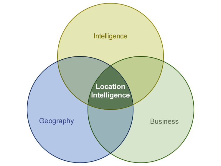
To produce location intelligence, one examines geospatial and business components to fully realize the situation, identify key factors, uncover patterns and relationships, and present possible solutions. Figure 1.1 depicts how Location Intelligence for Business is built on the principles of intelligence, geography, and business.
Note. Geospatial Intelligence (GEOINT) and Business Intelligence (BI) are separate areas of information and intelligence which should be recognized and not confused with Location Intelligence. GEOINT and BI are not examined in detail during GEOG 850, Location Intelligence for Business.
These three disciplines of intelligence, geography, and business have some unique foundational principles and share other, similar principles. Prunckun, Bacastow, and Lowenthal describe first principles as the fundamental concepts on which a theory or discipline functions. Fundamentally, geography is a spatial study of the earth’s surface; however, in practice, the science examines physical geography, human geography, and the environmental relationships of both.
Distance hinders interaction between places, events, and entities. Often described as the friction of distance, a consumer’s choice to purchase products locally rather than travelling a further distance can be measured in time and transportation costs. (Tobler, 1970: 234-240)
Geography is involved overtly and intuitively in business planning and operations. Geographic data, describing the location and attributes of things in the world, comes in many formats for use in analysis, creating maps, solving problems, sharing observations and insights.
Todd S. Bacastow, Teaching Professor of Geospatial Intelligence, Penn State University, introduced first principles of geospatial intelligence (GEOINT) that form a knowledge paradigm of the profession. Geospatial intelligence as a human process follows a methodology, is conducted in secrecy, and seeks to achieve an information edge or decision advantage. Integrating imagery, imagery information, and any available geospatial information, GEOINT reveals how “human behavior is constrained by the physical landscape and human perceptions of the Earth.” The discovery of relationships in space and time improve our understanding and anticipation of human patterns of life. (Bacastow, 2016)
Both human geography and census geography contribute to location intelligence. It’s a branch of geography studying patterns and processes that shape the human society; modeling human, cultural, societal, political, and economic factors.
Most business data points are linked to physical locations and times. Ryerson highlights the geoadvantage which an entity gains from analysis of geographic phenomena, human activity, and economic productivity.
A location-based research process starts with gathering all relevant internal business information and enriching it with relevant geographic information.
- Ask pertinent questions to identify key factors, data gaps, drivers which will influence the decision process.
- What business information relates to the problem?
- What business objectives are impacted by the problem?
To enrich the data for analysis, obtain geospatial information from within the organization, open sources, and reliable third-party vendors. Research geographic information, georeferenced data, specialize data, statistics, and references, in this case, business information. A geographic information system (GIS) is often used to manage, analyze, visualize, and gain an understanding of geospatial data. Relate how and where location is linked to the business information.
Conduct data enrichment to expand a resource of consumers, customers, demographics, market segmentation; often suitable to uncover customer patterns, behaviors, and trends.
An effective analysis process begins before an organization faces a problem or opportunity. Approach the situation with an educated, experienced process to develop relevant business questions, collect and enrich data, perform geospatial analysis, prepare to present findings with mapping and visualization.
A foundation for geospatial thinking in commercial settings begins with educating analysts and establishing a base for subsequent technical training in specific location intelligence applications.
The geospatial professional must practice and demonstrate critical thinking and geospatial reasoning to each problem analysis. The basis of Location Intelligence reflects core geospatial and business principles:
- Events are related by space and time.
- Objective is to engage customers and gain an advantage for the business, in some cases, to disadvantage competitors.
- Determination is made as to which references, rules, regulations, laws apply to the business question.
Read:
- Pitney Bowes. 2017. When it Comes to Analytics Success, X Marks the Spot: Location Intelligence is Driving New Insights and Providing Surprising Benefits. [3] Harvard Business Review: Analytic Services. 3 Oct 2017. White Paper.
Note: Readings can be found in Canvas, Lesson 1, organized by topic.
Waldo Tobler. (1970). A computer movie simulating urban growth in the Detroit region. Economic Geography 46(Supplement): 234-240.
Mark M. Lowenthal. (2015). Intelligence: From Secrets to Policy. Thousand Oaks, CA: CQ Press. Sixth Edition.
Bacastow, Todd S. (2016). Viewpoint: A call to identify first principles [4]. NGA Pathfinder.
1.3 Intelligence Analysis Principles
Intelligence is the result of information analysis. Information alone does not drive decision-making or inform leaders of the optimal course of action necessary to achieve strategic goals. An analyst or group of specialized professionals collect, analyze, and evaluate information to produce intelligence which benefits their organization.
Competitive Intelligence
Information, human behavior, and geopolitical forces are in constant flux. The timeliness of intelligence significantly impacts the outcomes of a leader’s decisions. Thus, intelligence is a formal process, a continuous cycle, as information is gathered, accessed, and resulting outcomes are disseminated and used to set new collection requirements. The cycle is a framework for competitive intelligence, conducted in secret to gain a decision advantage over adversaries.
An entity conducts intelligence when competition exists, and power is the leverage to maintain security against an adversary’s threats. The key is to develop and apply intelligence to achieve strategic objectives; converting power to an advantage for the nation or organization. National intelligence supports policymakers and exists to avoid strategic surprise and maintain the secrecy of information, needs, and methods. (Lowenthal, 2015: 2)
First Principles
To Prunckun, secret research is founded on the first principles of intelligence. Competition between adversaries drives decision makers’ priorities and defines the intelligence requirements. The result of intelligence analysis must be that “Intelligence enables the analyst to present solutions or options to decision makers based on defensible conclusions.”
First principles of intelligence research and analysis coexist in the intelligence cycle and production of assessments to meet policymaker requirements:
“The theory’s six propositions state that intelligence research is: 1) conducted in secret, 2) identified within the intelligence cycle process so that data collection and analysis can be problem focused. In this regard, intelligence analysis can be 3) offensive as well as 4) defensive, but 5) it must be timely, and 6) its findings need to be defensible.” (Prunckun, 2015: 31)
Intelligence is typically conducted in secrecy to conceal information, uncover hidden information, and identify other governments' methods of espionage or discovery. Denying an opponent’s access to key information is critical to maintaining secrecy and is as important as exposing that adversary’s hidden information, capabilities, and intentions. (Lowenthal, 2015: 400)
Propositions can also be referred to as conditions in Prunckun's theoretical work.
Whether to support a nation’s strategies or an organization’s business objectives, the purpose of intelligence is to collect and analyze information which decision makers require and gain an advantage.
A formal intelligence process forms a cycle of identifying requirements, collection, processing and exploitation, analysis and production, dissemination, consumption, and feedback. Requirements and priorities focus the effort of an organization or intelligence agencies and, ostensibly, improve the effectiveness of intelligence production.
Lowenthal describes collection as the bedrock of intelligence; influenced by the variety of collection means, intelligence methods, and effective feedback from policymakers. (Lowenthal, 2015: 87) We will review methods of collecting geospatial information and business data in Lessons 3 & 4.
Read:
Prunckun, Henry. 2015. First Principles of Intelligence Analysis: Theorising a Model for Secret Research [5]. Salus Journal. 2015: Issue 3, No. 1.
1.4 Location Intelligence
Throughout the course, I encourage you to note examples of geospatial, intelligence, and business principles in the development of location intelligence. Businesses leverage spatial patterns and relationships in data to improve their operations and marketing. Business leaders also have a responsibility to optimize the spending or costs of research, operations, marketing, sales, and distribution. Analysis results and assessments from Location Intelligence provide advantages relating to business costs, return on investment, and profits.
Creating an Advantage
Businesses depend on creating an advantage for their organization or disadvantaging the competition. Location intelligence produces insights for a business to optimize their performance, leveraging advantages of geography with their product or service. Enterprise-wide databases now link geospatial attributes to assets, product features, operational tables, and customer relationship management (CRM) data. The next steps for integrating mapping services with key functions include web GIS, APIs and SDKs, multiple mapping visualizations (2D, 3D, webmap), dashboards, connected sensor data collection, IoT with real-time services, field data collection for asset management, and interior space mapping.
Location intelligence is not a formal discipline, nor universally defined or presented. It is also not a new concept since it is estimated that 80% of all data may have a location component. A key point to understand is Intelligence is not collected; it is produced after collected data or information is evaluated and analyzed. There is growing momentum for commercial applications in geospatial technologies, geospatial intelligence, and widely incorporating GIS into operations and databases. Beyond traditional site planning, location intelligence is now a blend of science, location data, human geography, and business information. Location-based studies begin with these elements and go on to identifying principles at work in a business problem.
We see location intelligence described or practiced in three ways:
- Location intelligence as a process
- Location intelligence as a product
- Location intelligence as platforms or software systems that perform geospatial analysis
Location Intelligence has applications in many disciplines and is generally considered to consist of five fundamental components:
- clearly stating a location-based analytic question
- data management, georeferencing, web mapping of key information
- geospatial analysis for patterns or significant factors
- visualization, presenting, reporting for decision making
- integration into the organization’s strategy and operations
Location Intelligence provides insights for businesses on markets, consumers, product adoption, relative location information, and customer needs, behaviors, interactions. Analysis is performed to identify and understand patterns; not solely to provide use cases to support planned courses of action.
Using location intelligence gives a business a decision advantage to achieve business objectives; results of the geospatial analysis provide insights for the business to organize, operate, and/or perform better than their competitors. Understanding and applying a scientific method of study or workflow of analysis is foundational to examining geospatial data for patterns, solving complex problems, and anticipating threats.
Location Intelligence Workflow
Fundamental to GEOG 850, the process of location intelligence is a problem solving and discovery process. You will apply a conceptual model or workflow to develop Location Intelligence for each activity and your term project. Your ability to communicate results, recommendations, or decisions is as important as your skills in research and analysis. For each deliverable, apply effort to provide effective visualization and presentation of your discoveries.
Consider the elements of this location intelligence workflow:
-
Identify a location-based business problem or situation
-
Restate the problem as a business question with goals and objectives (that lead to an actionable decision)
-
Gather and enrich all relevant data: internal business information, geospatial information, open source, third-party
-
Perform geospatial analysis to model; discover patterns and relationships
-
Predictive analysis to anticipate outcomes
-
Expected future behavior of consumers
-
Prescriptive analysis to recommend courses of action
-
-
Map, visualize, chart, and present for actionable decision
Location intelligence has different meanings, purpose, and terminology. Depending on context, location intelligence is a definition, a method of geospatial analysis, a subset of business intelligence, or software application for business analysis. It is an intelligence activity, conducted confidentially to gain an advantage for the business.
A succinct definition of location intelligence must also be sufficiently broad to apply to many disciplines. The foundation lies in principles of intelligence, geography, and the discipline under investigation—in this course—business. Location intelligence is the collection and analysis of many sources of geospatial data that are transformed into strategic insights to solve a variety of business challenges.
Location Intelligence Definition
Location intelligence in business is the practice of collecting, enriching, and analyzing business information, georeferenced data, and geospatial information to discover contextual insights for location-based challenges or opportunities. The process of location intelligence is often conducted confidentially to gain a decision advantage for the organization or to disadvantage competitors. Human geography is also a factor; to recognize and appreciate relationships between human behavior and our environment.
Read:
- Murphy, Alexander B. Geography: Why It Matters. Chapter 1 (p. 1-30). Cambridge, UK: Polity Press. 2018.
The Geography: Why it Matters reading is from the required textbook for this course.
Deliverable:
1. Post a comment to the Lesson 1.4 Discussion Forum in Canvas, including:- How well does the definition of Location Intelligence describe the process for business?
- your rationale;
- citations of pertinent references you used.
2. Don't forget to read, and then comment on another student's definition of location intelligence.
Due Tuesday night 11:59 pm (Eastern Time)
Please refer to the Calendar in Canvas for specific time frames and due dates.
1.5 Term Project - Overview and Weekly Deliverables
Throughout this course, a major activity is a location intelligence project that you will develop and research on your own (with some input from everyone else taking the course). To ensure that you make regular progress toward completion of the term-long project, I will assign project activities for you to complete each week.
The topic of the project is completely up to you, but you will have to get the topic approved by me. Pick a topic of interest and use the different methods applied during this class to better understand the topic. Some topics considered include:
- Location intelligence, Resources & Synergies Development (R&SD), operations, services, sales and business development, marketing, C-suite decision making, procurement, supply chain management, or telecommunications;
- Not just digital customer experiences, also optimizing the use of building and manufacturing space;
- Production machines talking to one another through connected sensors and IoT;
- City infrastructure sensing activity or phenomena, reporting the occurrence locally, and responding with safety, efficiency, recommendations for correction.
You will need to demonstrate what you have learned throughout the course. Your grade will be based upon demonstrating an understanding of:
- demographic and psychographic/behavioral profiling and market segmentation;
- trade areas; natural and man-made features affecting business opportunities; sales forecasting/market penetration;
- site characteristics typically investigated in the site selection process;
- solving or contributing to the solution of a business problem using geospatial analysis methods; and
- tools such as reports and maps; and how they inform market research, site selection, or support business decisions.
Take time this week to consider the following:
- What would you like to focus on—a broad market analysis, a site selection problem, leveraging indoor or digital location analytics, or something else?
- What level of geography would you like to work with? What location?
- What steps might you take in your research? Is the data readily available (or can you gather it and incorporate it, using the tools at our disposal)?
This week, the project activity is to become familiar with the weekly term project activities and to think about possible topics. Each week, the project activity requirements for that week will be spelled out in more detail on a page labeled Term Project, located in the regular course menu.
Note: All Term Project related work and deliverables will be submitted in Canvas during weeks 2, 3, 4, 6, 8 and 10.
Approach to a Location Intelligence Project
Design and follow a systematic approach to your project as you examine the problem, objectives, and decision making process. Lessons 1 – 4 will introduce geospatial and business principles used to form location intelligence. The lessons build a case for solving your location-based problem by asking a relevant business question, gathering and enriching data, applying geospatial analysis, uncovering factors, patterns, and contributing phenomena.
Week by Week Activities of the Term Project
Below is an outline of the weekly project activities for the Term Projects. You should refer back to this page periodically as a handy guide to the project 'milestones'. NOTE: I highly recommend keeping a regular diary of your activities on the Term Project. If you do this carefully enough, then the final report for the project should almost write itself!
| Week/ Lesson |
Points | Detailed Description of weekly activity on term project |
|---|---|---|
| 1 | — | Read this overview! Start thinking about your term-long project, researching location intelligence topics, and identifying data sources. |
| 2 | 20 | Brainstorm a few ideas you have for your Term Project and share them in a post to the 'Term Project: Brainstorm Project Ideas' forum in Canvas (Lesson 2). Respond to several colleagues’ ideas. |
| 3 | 20 | Submit a brief project proposal (a few paragraphs) to the 'Term Project: Topic Idea" forum in Canvas (Lesson 3). Provide feedback to at least two classmates on their Project Topics. This week, you should start to obtain the data you will need for your project. |
| 4 | 30 | Finalize your project proposal. Submit your project proposal with abstract to the 'Term Project Discussion – Project Proposal with Abstract' drop box in Canvas (Lesson 4). |
| 5 | — | Continue revising your project proposal, research key references, identify data sources. No deliverable is required for your term project. |
| 6 | 55 | A revision to your project proposal with data sources is due this week. This will commit you to some targets in your project and will be used as a basis for assessment of how well you have done. The final proposal with data sources should be submitted to the 'Term Project: Revised Project Proposal with Data Sources' drop box in Canvas (Lesson 6). |
| 7 | — | You should aim to make steady progress on your project this week. No deliverable is required for your term project. |
| 8 | 75 | Create a 5-7 minute PowerPoint or similar presentation and email me a URL link to your .mp4 or video. Submit your presentation to the 'Term Project: Project Update Presentation with Audio' forum in Canvas (Lesson 8). |
| 9 | — | Continue revising your project proposal, research key references, identify data sources. No deliverable is required for your term project. |
| 10 | 100 | This week, you should complete your project work and submit it as a Word or PDF file to the 'Term Project: Final Project Report' drop box in Canvas (Lesson 10). |
| 300 | Total Points |
Term Project Deliverable:
No Deliverables Due This Week: Not a deliverable; but please take time to familiarize yourself with the schedule for the term project.