People and goods can move from one location to another by traversing a transportation network. There are many types of transportation networks including street networks, railroad networks, pedestrian walkway networks, river networks, utility networks, and pipeline networks. A geospatial model of a transportation network is comprised of linear features and the points of intersection between them. The modeling and analysis of networks has so many applications that there is an entire branch of mathematics devoted to it known as graph theory. In graph theory, linear segments of the network (e.g., road segments) are referred to as edges, and the points where the linear segments connect are called nodes.
Some transportation networks permit travel in both directions such as street networks and are referred to as undirected networks. Other networks generally limit travel to a single direction such as pipeline networks. These networks are referred to as directed networks. In ArcGIS, undirected networks are modeled with network datasets whereas directed networks are modeled as geometric networks. In this course, we will limit our study to street networks and the use of network datasets to model them.
Many transportation problems can be addressed through a network. A few examples are listed below:
- identifying the fastest, shortest, or most scenic path between two points on the network;
- determining the most efficient way for a delivery vehicle to visit a series of stops (also known as the traveling salesman problem);
- defining the service area around a given location;
- identifying an optimal store location.
We will take a detailed look at some of the more common network analyses in the next lesson. In this lesson, we will focus on the components of a transportation network model and the mechanics of creating one.
While a high-quality set of roadway centerline data is certainly a prerequisite to modeling a transportation network, it is by no means sufficient. Other important elements of a network model include the following:
-
Topology
The topology of a street network refers to the spatial arrangement and connectivity of the roads which comprise the network. Understanding how the road features relate and connect is critical to determining which paths or routes through the network are possible. Elevation is an important consideration in establishing network topology. Physical connections between streets require not only that they cross in the x-y plane but also that they cross at the same elevation. The picture below shows a complex interchange where many roads cross, but there are limited points of connectivity.
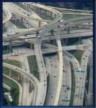 Figure 4.1: Complex Highway InterchangeCredit: ESRI 2010 User Conference Technical Workshop
 -
Cost Attributes
In order to select the “best” route between two points in a network, you need to define what you are trying to accomplish. Perhaps you’re interested in determining the shortest route. In this case, you would need to know the distance between all adjacent nodes in the network. Consequently, the edges would need to have an attribute which quantifies length. Alternatively, if you want to know the fastest route between two points, you need to know the time it takes to move between any two adjacent nodes. Consequently, to support the fastest route determination, the edges need to have an associated time attribute or a speed limit attribute, since time is a function of length and speed limit. Regardless of how you define “best,” you need to have a corresponding attribute or attributes which allow the cost of potential routes to be quantified and compared. For example, if you want to know the most scenic route between any two points in the network, you would need to have a scenic score attribute associated with each edge which quantifies its scenic value.
-
Turns
Turns also play a key role in modeling a street network. One fundamental consideration in regards to turns is whether they are permitted. Many road intersections do not permit U-turns, for example. A second consideration for turns is the length of time they take. Left turns generally take longer to complete than right turns, since you generally have to contend with oncoming traffic. In order to accurately estimate how long it would take to traverse a network along a specific route, turn delays need to be taken into account.
-
One-Way Restrictions
Another important data element for a street network relates to one-way roads. In order to ensure that only legitimate routes are considered, roads which limit travel to one direction need to be identified.
-
Traffic
We all know that traffic plays an important role in determining how long it takes to traverse a particular route. Consequently, historic traffic data, or better yet, live traffic data, can be extremely useful in a street network model.
-
Directions
Often one of the desired outputs of network analysis is a set of description directions. In order to support the production of meaningful directions, a variety of descriptive roadway attributes needs to be present. Signpost data can also provide a valuable source of information for the creation of meaningful directions.
As you can see, a lot of information is required beyond basic roadway centerline geometry in order to create a street network which can support network analysis and produce high-quality results.