Lesson 2: Geography Fundamentals
2.1 Overview
In this lesson, we are going to discuss definitions of geospatial intelligence, the scope of the subject, and examine why geography as a subject and a discipline is fundamental to the idea of geospatial intelligence. For those of you out there who are geospatial intelligence practitioners and professionals, the definition of geospatial intelligence may seem obvious, i.e., "geospatial intelligence is what my agency says it is, and the scope encompasses what we do..." However, as you will find out, different people and different agencies have different understandings of the definition and scope of the field.
It also may seem apparent to some that geography and geographical understanding and knowledge obviously underlay any field called "geospatial intelligence." However, it is quite possible that geospatial analysts have very little if any geographic knowledge and understanding. At Penn State, we think that is a real problem and one of the main reasons that a course entitled "Geographic Foundations of Geospatial Intelligence" is the foundation course of the Certificate in Geospatial Intelligence. So here is a fundamental concept of this course:
A reasonable knowledge of geography and associated geographical viewpoints is essential for all practitioners of geospatial intelligence no matter their agency, mission, focus, or specialization.
Lesson Objectives
At the end of this lesson, you will be able to:
- define Kant's three ways of ordering knowledge;
- define "Geography" and discuss the taxonomy of the word;
- define the terms Human Geography, Physical Geography, and Geographic Information Science and Technology (GIS&T); provide examples of each (sub-disciplines); discuss the relationship between the three;
- affirm or criticize, based on your own opinion and experience, the relevance of Human Geography to the field of Geospatial Intelligence;
- argue or defend how the definition of Geospatial Intelligence is socially contested and constructed; provide at least one organizational definition (e.g., NGAs) and argue or defend your own definition;
Questions?
If you have any questions now or at any point during this week, please feel free to post them to the GEOG 882 - General Discussion Forum in Canvas.
2.2 Checklist
Lesson 2 will take us one week to complete. Please refer to the Calendar in Canvas for specific time frames and due dates. Specific directions for the assignments below can be found within this lesson.
Complete the following steps to complete Lesson 2:
- Work through Lesson 2 in this website.
- Read (the following are available in Canvas):
- Wikipedia article on Geography [1]
- Chapter 1 in: de Blij, Harm (2012). Why Geography Matters More than Ever. New York: Oxford University Press. (Located in Canvas)*
- Chapter 6, titled "Geospatial Intelligence and the Geospatial Revolution," in: Siedschlag, A., & Jerković, A. (Eds.). (2015). Cross-Disciplinary Perspectives on Homeland and Civil Security. Peter Lang Publishing. (Located in Canvas)*
- View both Episodes One and Five of the Geospatial Revolution Series (embedded on page 2.4).
- Participate in the "Geography Definitions" UNGRADED Discussion Forum.
- Participate in the "Human Geography Sub-discliplines" UNGRADED Discussion Forum.
- Participate in the "Lesson 2 - GRADED Discussion Forum (#1)".
- Take the Lesson 2 - GRADED Quiz (#2) (30 points).
* Students who register for this Penn State course gain access to assignments, all readings, and instructor feedback, and earn academic credit. Information about Penn State's Online Geospatial Education programs is available at the Geospatial Education Program Office [2].
2.3 Kant's Three Ways of Ordering Knowledge
Immanuel Kant [3] (1724-1804) was a famous German philosopher who lived in Königsberg in East Prussia (now Kaliningrad, Russia). He was one of the great thinkers of the European Enlightenment. Among his many ideas was his conception of how all knowledge might be organized. Kant said that there are three ways to organize all knowledge: the topical approach, the chronological approach, and the spatial approach.
- Topical Approach: A topical approach is to know everything about one thing. Thus, political science is a topical approach, as it involves everything about politics. Economics involves everything concerning financial economies, and biology concerns all knowledge about living things.
- Chronological Approach: A chronological approach looks at how things change over time. This is the approach of historians as they examine how the world has changed over time. Historians focus on what has happened in the past.
- Spatial Approach: A spatial approach looks at where things happen and why. This is the fundamental approach of geographers as they try to understand the world in terms of where things happen, why and how they happened there, and the interactions between phenomena in one place relative to phenomena in others.
In reality, few people limit themselves to using only one of these ways of ordering knowledge. Political Scientists may focus on the politics of certain eras or places. Historians may focus on the history of a particular country. And geographers, as we will see, are great synthesists who invariably use the spatial approach in conjunction with topical and chronological approaches. Yet, Kant's three ways of ordering knowledge demonstrates that the spatial approach of the discipline of geography makes geography one of the core scholarly disciplines.
Knowledge Check
2.4 What Is Geography?
People use the word "geography" all the time. And while it has many uses and meanings, most people would be at a loss to define what "geography" is. We are going to examine the definition and scope of geography, but before we do, I want to see how you might define "geography."
Discussion
Without any research or outside help, please return to Lesson 2 in Canvas and enter your short definition of "geography" in the Lesson 2 - Ungraded Geography Definitions Discussion Forum. If you see another definition you would like to comment on, feel free to post a reply.
Geography Defined
Let us take the word "geography" apart. The word geography can be broken into the two basic elements of "GEO" and "GRAPHY." Geo comes from the Greek word for earth (the word Gaea, also meaning earth, derives from the Greek as well). The "ography" part comes from the Greek word graphein, which is literally to write about something. The word "graph" derives from the same basis.
Thus, GEO + GRAPHY literally means "to write about the earth." We have commonly come to understand that the translation might also be taken to describe and map the Earth. The American Heritage Dictionary defines geography as "the study of the Earth and its features, inhabitants, and phenomena." I agree with the dictionary, but I like to tell my students that geography really is the study of how the world works in terms of the physical and human processes that occur every day.
So for me, Geography is really about how the world works. That is pretty good knowledge for a geospatial analyst to possess.
Breaking it Down
Understanding how the world works is a pretty tall order, so let us break down the study of geography into some manageable parts. At the most basic level, think of geography as a coin with two sides.
- HEADS: On one side, we have Physical Geography, or the study of the spatial distribution and attributes of naturally occurring phenomena.
- TAILS: On the other side, we have Human Geography, or the study of the spatial distribution and attributes of human-induced/engineered phenomena.
Physical geography looks at the natural processes that make the surface of the Earth the way it is. Physical geography includes the three major subdisciplines of Geomorphology, Meteorology, and Climatology.
Geomorphology
Geomorphology is the study of landforms and landform processes. Geomorphologists want to know:
- What are the different landforms?
- Where are the different landforms?
- Why are they where they are?
- How do they form?
- What will happen to them over time?
Meteorology
Meteorology is the study of atmospheric weather processes. Meteorologists want to understand:
- What are the different atmospheric processes that create our weather?
- Where do these weather phenomena occur?
- How and why does the planetary weather system work the way it does?
- What will happen with the weather in the future? (This will allow them to forecast the weather.)
Climatology
Climatology is the study of climate, which is basically the long-term pattern of temperature and precipitation. Climatology, like meteorology, is a branch of the interdisciplinary field of Atmospheric Science. Climatologists seek to understand:
- the different climate types found on Earth;
- the processes that cause these different climate types to occur in specific places (i.e. why are there different climate types);
- the places where these climates occur;
- how and why climates change over time; and
- what will happen to the earth's climate in the future so they can forecast the effects of climate change.
Human geography
Human geography looks at the human activities that make the surface of the earth the way it is. Human geography includes numerous subdisciplines, some of which are:
- population geography
- cultural geography
- economic geography
- political geography
- and many others
Human geography is essentially synthesizing a spatial perspective with one of the topical disciplines to come up with new knowledge and a new perspective to understand how the world works.
Discussion
Can you think of some other human geography subdisciplines by combining a topical approach with a spatial perspective? Please return to Lesson 2 in Canvas and enter your list of other human geography subdisciplines in the Lesson 2 - Ungraded Human Geography Subdisciplines Discussion Forum. Feel free to post comments to other lists you see in the discussion forum.
Geographic Techniques
The world is fortunate that geographers through the ages have developed a set of spatial tools to help us understand how the world works. These tools are often referred to as the geographic techniques and they include the subdisciplines of:
- Cartography: The art and science of making maps and the oldest of the geographic techniques;
- Remote Sensing: The art and science of obtaining information about the earth by study from afar;
- Geographic Information Systems: A GIS is a computer-based system that collects, stores, analyzes, and displays spatial information to solve problems; and
- Global Positioning Systems: The use of a system of satellites, ground stations, and receivers to obtain precise locational information of phenomena on the earth.
Geospatial intelligence relies heavily on the geographic techniques (collectively known as Geographic Information Science and Techniques (GIS&T or GIScience) for the collection, analysis, and communication of results. Your other coursework will involve very detailed explorations and applications of the geographic techniques.
Knowledge Check
Penn State Public Broadcasting has produced an amazing series of webisodes on the "Geospatial Revolution."
Please take the time to view Episode One of the Geospatial Revolution Series (13:45 running time) and think about how the revolution applies to this lesson.
Video: Geospatial Revolution / Episode One (13:44)
Welcome to the geospatial revolution.
Capt. Arturo Derryberry, U.S. Marian Corps: In a world where everybody's texting, geospatial technology is critical to understanding what's happening at a particular location.
Mark Brender, VP Communications, GEOEYE: It's the speed of the Internet. It's the capability of remote sensing satellites. It's software like Google Earth. Taken all together, you have an explosion in the way we view the Earth.
Text on screen: It starts with MAPS that show where everything is...
Walter Scott, Founder, Digitalglobe: Everybody's somewhere, everything's someplace, and a map is a way of organizing all of that information.
Text on screen: Made by REMOTE SENSORS from everywhere...
David Cowen: Professor Emeritus, University of South Carolina: It's information from aircraft, from satellites. It can be a collection of information from a tower that you've set up.
Text on screen: and GPS that tells you where you are now...
Kass Green, President, KGA Geospatial:We've been using maps for hundreds and hundreds of years to know where we are. Now, that nice lady tells me which way to turn.
GPS voice: Turn right, then turn left.
Text on screen: with INFORMATION that tells you what's there...
Adena Schutzberg, President, ABS Consulting Group: Virtually all of the information that you're sharing with anybody these days has some kind of geospatial tag on it.
Text on screen: from PEOPLE everywhere communicating with everyone...
Patrich Meier, Director, Crisis Mapping, Ushidi: It's really the human element. There's basically this entire information ecosystem that we have access to now.
Text on screen: inside MOBILE devices that put the world... in the palm of YOUR hand.
Joe Fancica, Editor-in-Cheif, Directions Media: I can receive information. I can transmit information. I can broadcast my location. And that is revolutionary.
Jan Van Sickle, Geomatic Engineer: It's amazing. It's cutting-edge. It's--well, changing the world.How We Get There
GPS voice: In 1/10 mile, turn right at stop sign.
David DiBiase, Dept. of Geography, Penn State: Some people will call this a GPS. It's not. It's a GPS receiver. It is, I think it's fair to say, a miracle of science and technology. It's able to collect signals from global positioning satellites far up in space.
Adena Schutzberg: Each one of them is, every moment of every day, saying, "This is the location that I'm at in orbit around the Earth." If you know where you are with respect to three satellite points, you can use mathematics to determine where you must be on the face of the Earth.
David DiBiase: There are millions of coordinates encoded in this box.
GPS voice: Recalculating
David DiBiase: And it can take those coordinates and render a map on the screen for you.
GPS voice: Turn left on Whitehall Road. Then turn left in 0.3 miles.
David DiBiase: Where do all those coordinates come from? Where do those streets come from? Lots and lots of people driving special cars continuously up and down every single road and digitizing those roads into a database that then can be downloaded into this little box.
[electronic beep]
How We Got HERE
Michael Jones, Chief Technologist, Google Earth: There's nothing new about mapping. You can imagine without being able to talk, somebody showing where you're going, and draw a line showing where the river is, and an X where they are now, and an X where they're gonna go.
Mark Brender, VP Communications, Geoeye: Viewing the Earth has really been based on technology. The Babylonians etched the lay of the land on clay tablets in 2300 B.C. And then in the 15th century, with the advent of printing, they started making maps using wooden blocks.
David DiBiase: Surveyors would map by making measurements in front of them to a reference point and then back behind to the reference point they had just passed. That information had to be transcribed into a map.
David Cowen: From in the air, it's as if we sent out thousands of surveyors all at once. Remotely sensed data provides highly accurate measurements of the Earth and the features upon it.
[rocket rumbling]
Gen. C. Robert Kehler, Commander, USAF Space Command: We rely on satellites for pictures of the Earth, for communications, for navigation, for weather. Geospatial technology has become woven throughout the fabric of how we live.
Jack Dangermond, President, ESRI: About 50 years ago, people came along and started building on big old mainframes geographic information systems which would integrate on a map information about culture, about population, about demographics, about physical environment. GIS allows us to bring it all together.
Jan Van Sickle: I used the first commercial GPS receiver. Took two men to carry it. Our antenna was a meter-square piece of aluminum. We had to have a generator for it. Massive batteries!
Tim Trainor, Cheif, Geograph Division, U.S. Census: The census bureau in the United States needed to capture all of the line work for roads, railroads, hydrography, and then boundaries. That formed the basis of the first TIGER files in the late 1980s in support of the 1990 census. Tiger was an impetus to technological developments like MapQuest, Yahoo, followed by Google.
Text on screen: TIGER.Topologically Integrated Geographic Encoding and Referencing
Matt O'Connell, CEO, Geoeye: Google Earth introduced people to the coolness of place. "I am here. Where's the nearest Starbucks?" Or, "Where's the nearest hospital?"
Chris Pendelton, Technical Evangelist, Bing Maps: Now we're all carrying around GPS. We've got really rich interfaces that allow us to do things that we would only imagine previously.
Michael Jones: On a mobile device, you are the center of the map, and the city is around you, not you see a city and then look for yourself on the map. It's putting you in the map.
[electronic tone]
[horn honks]
[phone rings]
Adena Schutzberg: Say you find yourself in a location that you don't know very well. You might want to find a place to have dinner. Well, what places are around? And which places have other people rated very highly? Maybe you want a particular kind of food within a 15-minute walk.
David Cowen: I've got not only a restaurant, but I've got the map. I can find the reviews of it. I can find out what the menu is.
Chris Pendelton: We're moving away from me having to actively search for something, to now search is telling me what I should check out that might be interesting to me. These are the things where location and search start to come together.
Why We Need It
Joe Fancica: We're becoming individual sensors. We're creating this huge sensor network of people holding these mobile devices. And that information is two-way.
[electronic beeping]
David Cowen: It's not just passive collection, listen to your GPS technology, tell you how to get to some place. You're gonna say, "Wait a minute. "I see a problem. "I want to report that problem." "I want to see that someone's going to respond to that."
Jean Philippe Frantz, Carrefour, Haiti: We were playing basketball. We see, like, the ground keep on moving. I see a lot of people, some of them dying, like the ceiling, like, killed them.
Jean-Robert Durocher, Entrepreneur, Cambridge, Massachusetts: I have both extended family members and close family members who live in Haiti. And the first reaction was more, like, surreal."Is this really happening?"
Capt. Arturo Derryberry: We needed to know where we could go in. And so, we used geospatial technology to prepare the area with information before we even got there.
Craig Clarke: Approximately 2/3 of the cell towers stayed active. And aid workers and Haitian nationals were posting information saying that they needed help.
Patrick Meier: I was watching CNN and immediately called our USHAHIDI tech lead in Atlanta. I told him that we really need to move and set up an USHAHIDI platform for Haiti.
Jaroslav Valuch, Field Representative, USHAHIDI: USHAHIDI is an open-source platform for crowd-sourcing crisis information. Basically, that means you are following local media, Twitter, Facebook, text messages, any sort of information you can get. Once you aggregate this information, you map it, you have a real-time picture of the actual situation on the ground. This information can be used by rescue workers or anyone.
Patrick Meier: With an USHAHIDI platform, you can decide what kind of map you want to use. OpenStreetMap uses crowd-sourcing to do street mapping. And within a few days, OpenStreetMap had the most detailed map of Haiti that was available.
Kate Chapman, President, Openstreetmap, USA: There were maps of Haiti before the earthquake, but they just weren't up-to-date anymore. So people started using donated satellite imagery to trace in OpenStreetMap collapsed buildings, clinics, hospitals.
Patrick Meier: Within a week or so, we had trained over 100 individuals at Tufts University to map the incidents and the alerts. And then a text number, 4636, was set up for reporting. But these text messages were all going to be in Creole. So we started getting as many Creole-speaking volunteers as possible.
Jean-Robert Durocher: I found out about the 4636 effort through a friend of mine. So I got online, started getting involved, basically staying up late after putting the kids to bed, try to translate as many text messages as I could.
Various unknown speakers within a group: Our top priority is Port-au-Prince. It's good. It's good, good translations.
Jean-Robert Durocher: There was this energy.
Unknown speakers: Today's SMS.
Jean-Robert Durocher: People from basically all over the world creating this sort of, like, support system over the internet.
Craig Clarke: A soccer stadium was serving as a camp for displaced persons. But we didn't know it was there. Through USHAHIDI's mapping ability, we knew that that would be a location to take aid. We wouldn't have seen it without them.
Capt. Arturo Derryberry: USHAHIDI alerted the world that if you've got needs in Haiti, or you're trapped in a building, or you're out of food, or you're injured, and you need help, that you can alert us.
Text on screen: More than 2,000 volunteers and 20 organizations from 49 countries participated in the Haiti crisis mapping effort.
Craig Clarke:Whether you are that person in Des Moines, Iowa, who's reading Twitter or Facebook, or you're a Haitian on the ground, with mobile technology and open-sourcing of information, you're suddenly empowered.
Unknown speaker:I work from California.
Jean-Robert Durocher:Being able to stay online translating those text messages, and you know that that information will be forwarded directly to a specific aid organization. That made it feel like, almost, I was on the ground helping.
Jack Dangermond:A map is worth a million words. Maps communicate with everybody. That's powerful. You know, you can make a difference. You can look at relationships and patterns and processes and models, help save the world.
Joe Fancica: I don't think we can project 50 years out, but given what we're seeing today, it's just a fantastic explosion of location technology. And location-based data. And now we have the devices to read it and capture it and visualize it. And that's something that's really helping the geospatial revolution truly explode.
Walter Scott: Revolutions rarely end up the way they started. That's almost the definition of a revolution.
Video: Geospatial Revolution / Episode Five (21:28)
Mapping the Pandemic (somber music) (suspenseful music) Al Powered Early Warning (bell ringing) - [Peter Coyote] 1854, London. In the wake of a cholera epidemic, Dr. John Snow placed cholera deaths on a grid to confirm the source of the outbreak as water from a single pump. Geography is central to fighting disease. New Year's Eve 2019, 166 years later, a global infectious disease surveillance system detects an unidentified respiratory illness emerging in Central China. The threat was real. And the platform issued the warning nine days before the official WHO report. The system was built by an interdisciplinary team at BlueDot, a small startup out of Toronto; using artificial intelligence and machine learning to scour the internet for clues of emerging infectious disease. - When we're talking about the problem of infectious diseases, we need a diverse set of data. We can't just be tracking a microbe, we need to understand how people are moving across the planet, we need to understand in some situations climate conditions, animal populations, health systems. And so when we think about where geospatial technologies are going, there's this massive increase in production of data that are all associated with a place and time. And geospatial technologies now allow us to wield those data to integrate them and to make sense from massive amounts of data to derive an actionable insight and to do this in real time. - [Peter Coyote] In an unequal world where official reports of outbreaks are not always timely, epidemiology's pressing need is to develop surveillance capacity, to sift through the layers of data that can predict an outbreak. - So we've been using machine learning and natural language processing to stitch together a global panoramic view of infectious disease threats that are appearing around the world. And so our algorithms are scanning through vast amounts of online sources, open source data, in 65 different languages and looking for these early signals that maybe there's an unusual cluster of a disease happening. It might be a disease that we know of, or it might just be a syndrome in the way that we in fact picked up an early signal that there was an unusual cluster of pneumonia cases in a city called Wuhan. [Peter Coyote] These global tracking systems, mine, process and filter myriad information sources to essentially create a living breathing map of risk information. And to build it takes a host of experts ranging from public health to data science to veterinary medicine. - This is inherently a complex problem, and it requires a diverse set of skills and perspectives. - [Peter Coyote] This emerging field of digital epidemiology and disease surveillance is a mashup of computer science, statistics and big data mapping. Algorithms are trained to understand disease terms and to process whether an alert is relevant. And while detection is the first concern, dispersion of the pathogen is the second. - [Kamran Khan] Human population, mobility and movements are critical to understanding how diseases spread. So humans in essence have become the vectors that are transporting diseases inadvertently across the planet. So within the span of about a second or two, we had automatically now assessed how Wuhan was connected to the rest of the planet and which places were in the path. If this thing were to spread out further, where should we be looking for it next? - [Peter Coyote] The only requirement for the spread of COVID-19 is proximity and movement. Transported undetected by their human hosts, the virus crossed borders worldwide. (suspenseful music) Tracking a Pandemic in Real Time At Johns Hopkins University in Baltimore, a small team led by Dr. Lauren Gardner had been watching the outbreak with deepening concern. - [Lauren Gardner] I saw this as a really unique opportunity to start building out a dataset on an emerging infectious disease in real time. - Dr. Gardner and I, we had a very small group team meeting. She suggested to me why don't you create a dashboard for the coronavirus because she knew I was from China and very anxious to know what's the situation in China and know my relatives, my friends and how they were doing. - [Lauren Gardner] My student Ensheng Dong and I were basically the two that started this and he's a total wiz with dashboard development. - After I talk with Dr. Gardner, I went back to the office. I spent eight to nine hours and came up with the first version of the dashboard. - [Lauren Gardner] And so we built the dashboard that night and then the next day shared it publicly. - The dashboard went viral after that. - I don't know how many views the Hopkins dashboard got and continues get, but I'm sure it's off the charts. - They are in fact, the creators of the most viral map-based application in the history of the world. - Four or five billion maps are generated off that website every day. Sometimes it was as high as 10 and 12 billion on a day. That meant that people were looking at it and re-looking at it and seeing the trends. - [Gardner] We massively underestimated the interest of the general public in following the progression of this outbreak. [Nita Bharti] For a lot of people being able to see disease data in a spatial format meaning an interactive map was a really important way for them to understand what was happening and also for them to assess what their immediate risk was. - This was a huge day of awakening for the world because they began to see the power of geospatial visualization in their own lives. - [Peter Coyote] The Johns Hopkins dashboard quickly became the authoritative source and public health officials rushed to create their own. - It was within a week that we started to see similar dashboards coming out and Hong Kong had a dashboard and Thailand had a dashboard and Korea had a dashboard. - And I remember the first time I saw it thinking, I want that including the map and the visualization of all the countries and all the cases in the red dots, I want that on our website. - Anybody who felt comfortable going into GitHub, could go pull those data, could pull the actual tables and the numeric data and make their own maps or do their own analysis. It was very transparent, it was updated regularly and it was easy to use. - [Este Geraghty] Never before have we really had this opportunity to watch real time data update. And that is the ideal for disease surveillance. - And this is why visualization of that work and the work that we've been doing on the ground is so critical because we need to know where things are happening so we can address them. We can focus our attention, we can accentuate our efforts and ultimately we can drive resources to those very communities that are seeing the disproportionate impact of this horrific pandemic. (suspenseful music) - [Peter Coyote] Days before the WHO called the crisis a pandemic, the Johns Hopkins map showed it to be true. The small clusters of red dots had grown larger and crossed borders. But dark spaces on the map marked where public health data had been withheld. One of these was Iran. In late February 2020, Iran's Ministry of Health reported 12 deaths, but posts on social media painted a darker picture. A team at Maxar Technologies used their human geography dataset and crowdsourcing platform to investigate the rumors, then confirmed them with high resolution satellite imagery. - The largest cemetery in Iran in Qom, what we were seeing from space... mass graves being dug. And so we saw trenches that were upwards of a hundred yards long. We saw large piles of lime to counter the odor and the decay. - [Peter Coyote] The satellite pictures suggested the number of dead was significantly higher than the official figure. - That then allowed us to be able to support in this case The Washington Post, to be able to publish an article to bring transparency. And I think having that type of shared experience where we all were able to see the impact of that, I think it helps drive behavior. (lively instrumental music) The goal is to understand what is normal and when is there a variance. This proliferation of sensors, whether those sensors are on the ground, through social media or passive sensors that are collecting data. If we can derive patterns from that, that then can help inform how we apply assets in space to be able to collect imagery and then extract the insights from that imagery in short timelines to be able to drive decision-making. - [Peter Coyote] From space, the signs of COVID could be seen everywhere. Passenger planes grounded, new hospitals built within months, St. Peter's Square on Palm Sunday empty. In Mecca, the crowds that visit the Kabaa, Islam's holiest shrine, told the story. - Going from densely populated cultural iconic location of interest to no one there and then the leaders at that location established mechanisms to create social distancing kind of a stark change in behavior. (suspenseful music) Mass Gathering Footprints - [Peter Coyote] On February 29th, 2020, the Trump administration announced new travel restrictions on Iran. The same day the US recorded its first death from COVID-19. Colleges canceled student travel programs, but many students had already boarded planes for spring break. - You see on news that spring breakers are still flocking to the beach in Fort Lauderdale. We thought, man, this is really reckless to have all of these people go from universities to one location, congregate who don't really feel the symptoms of COVID get together and then return back home and go back to their schools. We said, let's see if we can show that story in our mapping platform". - [Peter Coyote] To bring awareness to the situation, Tectonix, a data analytics and visualization company, planned to isolate and track cell phone users crowding onto a single beach using anonymized location data. - [Rob Gresham] As we zoom in towards the Fort Lauderdale Beach, we are saying "filter the geo-fence down to what you're actually seeing on the map". And then what you end up seeing next is an even more precise filter where we start drawing a lasso around devices on the beach. And you could just see the congregation of many many people. - [Peter Coyote] Once lassoed by the geo-fence, every beachgoer's cell phone location data could be tracked by Tectonix platform. [Rob Gresham] And then when we zoomed out in the days following, you could see these students returning to essentially all over the country. - [Peter Coyote] The team sent out a video on social media. - The next morning, checked Twitter and saw that we had millions of views. And we just said, "what the heck have we gotten ourselves into?" - [Peter Coyote] On March 15th all public beaches in Fort Lauderdale were closed. (lively instrumental music) By August, US COVID deaths had reached 160,000. Warnings about mass gatherings and social distancing largely went unheeded. And in South Dakota, the 2020 Sturgis Motorcycle Rally opened as scheduled, 250,000 attended. The Tectonix crew lassoed devices in all the hotspots and then tracked them back to their home states. - Sturgis was interesting because it happened to be a lot of middle-aged or older people. But when people flocked to South Dakota, it actually set off a series of events where South Dakota briefly was the epicenter for COVID spread globally for several weeks. - [Peter Coyote] In rural America, meat packing plants reached a crisis situation with COVID cases. Tectonix isolated an Indiana plant for a full month, the resulting footprint was huge. Devices traveled to 48 states and into Canada. - For whatever reason, the meat packing industry was very hard hit by COVID. And now I think we've seen a lot of the working conditions and how close people were on conveyor belts and that sort of thing. - [Peter Coyote] These demonstrations proved in case after case, how desperately interventions were needed. That responsibility fell to public health officials who found themselves facing an angry backlash against emergency measures as they prepared to roll out the largest vaccination campaign in American history. (suspenseful music) Engaging the Virus - Geospatial technology has been a huge asset for epidemiology... for understanding how outbreaks are moving through populations and understanding how we can get response to those populations. - Now you've got all this data, how are you then determining what you do there? How do you accentuate your communication messages? What are you pulling back? If it's a zero sum game you don't have enough resources, you can only do one or the other; you're gonna focus on where you have the most risk. The most proportion of tests that are coming back positive, the most hospitalizations, what's happening with deaths in that area. But then it's the next phase of it which is now about adding in the protective measures. Where are your PPEs? Where are the masks going? What are the data showing in terms of mobility? Are people wearing masks? Are they moving around? Are they not moving around? Are they staying close to their home? This is all geospatial technology and mapping that allows you to visualize. And then on top of that the last protective measure is on vaccines. - To monitor our vaccine inventory, to understand the population phases and how many people in each phase need to be vaccinated. To look at the vaccination venues. - Now you layer socioeconomic information, housing, transportation issues, challenges with social vulnerability index or what we call them SVI. Add in where you have increase in cases, hospitalizations, deaths and vaccine knowledge. And now you have a geospatial ecosystem that you can not just share internally, but share with your folks on the ground but also your policy makers, your elected officials, with the community who are looking at all this information and saying, "Gosh, I wanna protect my own family!" (suspenseful music) Wearable Technology Detection - [Peter Coyote] As vaccinations take hold across the United States, COVID-19 cases and deaths have dropped to their lowest levels in nearly a year. But even as the outlook improves, researchers are testing new methods to stop the next pandemic. A team at Scripps Research in San Diego has proposed using wearable technology to monitor a population for early signs of an outbreak. (heart beating) - So we're launching DETECT and we're really excited about this. Because this is a way to track from a smartwatch, a person's heart rate and to know well before people have fever and symptoms, whether there's a cluster of abnormalities that's happening. - [Peter Coyote] Roughly a hundred million Americans own a wearable health tracker. And this study only needs to gather physiological data from one or two percent of them to set up an effective public health surveillance system. [Eric Topol] We have a mobile app where people will be asked if they wanna join a research effort to track their health, their resting heart rate through their smartwatch. - [Peter Coyote] Once a person volunteers, readings from their device will be monitored continuously through the app. And they'll be asked to enter their vaccination dates and report symptoms. - [Eric Topol] In the setting of this COVID-19, it gives us a handle on things like heart rate, which we know is a great antecedent abnormality before people get sick. So by tracking people at scale, we'll be able to see an outbreak in a way that previously has not been obtainable. - [Peter Coyote] This new twist on telemedicine, the ability to perform medical interactions without face-to-face contact is especially important in the midst of a pandemic; when we simply can't test enough people in time to know what the virus is doing. - It's real time, it's continuous, it's scalable. And so we're really keen on this added ability to be able to detect an emerging problem in any part of the geography of the United States. (somber music) [Peter Coyote] The global pandemic has caused incredible pain and hardship. We have suffered great loss and isolation, and we have not seen the last of COVID-19. The reality is that the world has entered a pandemic era in which new pathogens continue to emerge and spread within populations. And more than ever, geography is central to fighting disease. - [Kamran Khan] COVID-19 I think has been an awakening and we can all agree none of us wanna be back here again soon. - We certainly have hope with the vaccine, but concern yet about the variants. We have a number of lessons learned, but it's unknown how well we'll do with applying those lessons. - I'm trying to think about it as an opportunity to make changes and to think about the world in different ways. What can we be doing? What kind of information can we be collecting? The limit to this technology and the limit to geography is really our imagination. - COVID-19... what it has done, it's allowed us to see a purpose that's bigger than ourselves and I think deep down, probably every one of us wants to feel like we're part of something that's just bigger than us. - Geospatial community stood up and I'm so proud of them. Their work has literally saved lives and made things understandable. It's a great day for the application of science and technology to this great challenge that's facing the whole world. (light instrumental music changing to somber music)
The Relationship of Physical Geography to Human Geography
In an Introduction to Geography class (usually for freshmen and sophomores), a fellow instructor likes to stress the point that physical and human geography are completely separate disciplines and that there can be NO mixing between the two. In fact, he makes a big deal that students must write this down, and put stars by it in their notes as this important point will most certainly be on the test. He then stops and lets them think about this statement as they dutifully write it down.
Now, you might be thinking that this contention that physical and human geography are completely separate and can never be mixed seems nonsensical—and you would be correct. Eventually, a few of the students start to grin and perhaps a bold one might challenge the instructor (not very often though).
The instructor then gets to point out to the students the fallacy of such a contention and makes the point that physical and human geography, like the sides of a coin, are absolutely inseparable. We know that physical systems can have enormous impacts on human systems (ask the survivors of Hurricane Ida). We also know that human impacts on the environment have been great. As humans have always modified the surface of the planet to scratch out a living or to build great civilizations (western Europe had a climax vegetation of forest—consider the landscape there now—forests are rare, protected, and highly valued).
I think that the geographic subdiscipline of Environmental Geography occupies the space in the center of the coin, gluing human and physical geography together. A problem in many modern geography programs is that students specialize in either human or physical geography with inadequate knowledge of the other side of the coin. The even greater problem is for students who specialize in the geographic techniques (whom I affectionately call "Techno-Geeks") and lack the necessary background in human and physical geography.
Here is the fundamental contention that justifies this whole course:
All the geospatial technology in the world can tell you what is happening where and when. It may even tell you something about how it is happening. The technology, however, will NOT tell you why it is happening. To understand the why, you must understand how the world works—and that is the value of human and physical geographic knowledge.
Required Reading
Now that you have a basic understanding of the definition and scope of geography, study the Wikipedia article on Geography linked from the Lesson 2 Checklist [7]. Compare and contrast what I have said with the article. Are there any significant differences, and if so, why?
The Four Traditions of Geography
There are some other ways to conceptualize the field of geography. Parkinson suggested that geography has four traditions: The Earth Science Tradition, Culture-Environment Tradition, Locational Tradition, and Area Analysis Tradition. Geographic techniques support these traditions. The chart below shows how selected subdisciplines fit within these four traditions.
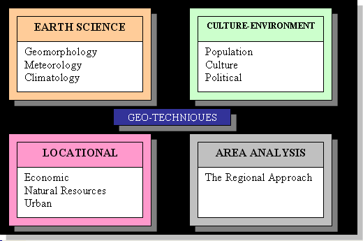
All the subdisciplines, with the exception of the Regional Approach, are topical approaches. The regional approach breaks the Earth down into areas that share certain uniform cultural and physical characteristics. Regional geographers then study the human and physical geography of that particular region. We typically break the world into the cultural regions of North America, South America, Europe, Russia and the Slavic World, the Middle East and North Africa, Sub-Saharan Africa, South Asia, East Asia, Southeast Asia, and Australia and Oceania.
Geographic Systems Theory
Yet another approach to understanding the scope of geography is Geographic Systems Theory. A system is a series of components such that, when you add energy to it, the components work together to produce an output. Take for example an automobile. Your gasoline-powered car includes multiple subsystems including the chassis with suspension and tires, the engine, the cooling subsystem, the transmission, the fuel tank (with fuel pump and fuel filter), the steering subsystem, etc. When you add gasoline, the engine generates energy, which the transmission sends to the wheels, which results in the output of the car moving. Open systems exchange both energy and matter with the outside universe. Closed systems exchange only energy.
The earth is a system. Is it a closed system or an open system? The answer is the earth is a closed system in that it exchanges energy with the universe, but it does not exchange any significant amount of matter (space junk and meteorites are insignificant—if the earth is destroyed by an asteroid I will admit I was wrong).
According to Geographic Systems Theory, the Earth has two major sub-subsystems, which are the Physical Subsystem and the Human Subsystem. The Physical Subsystem has four major component subsystems of the Atmosphere, Hydrosphere, Lithosphere, and Biosphere. The Human Subsystem has three major components of Beliefs, Institutions, and Technologies.
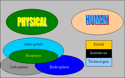
The atmosphere is the gaseous envelope that surrounds the earth and sustains air-breathing animals. The lithosphere is the solid rock and soil that comprises the outer solid layer of the planet. The hydrosphere includes all the liquid and solid water (water vapor is in the atmosphere). These three spheres are "abiotic" in that they are non-living. The final sphere is the biosphere containing all life. The biosphere relies on the other three abiotic spheres to function for it to sustain life.
A critical part of systems theory is understanding that if one system is significantly degraded, then the system function as a whole degrades. And if one system fails, then the whole system fails. If you consider that Planet Earth is the spaceship for the human race, and that we rely on all of its systems to function properly, you start to contemplate why we do not take better care of it. It is the only spacecraft we have and there are no lifeboats.
Geography as Synthesis
Geography is a synthesizing discipline in that geographers take topical subjects and analyze them through the spatial filter, thus seeing the world in new ways. This synthesis is very exciting and liberating in that geographers have the freedom to explore many different subjects and apply topical, chronological, and spatial approaches while integrating both the human and physical world. No other academic discipline takes such a holistic approach, and that makes geography special.
The Necessity for Geographic Literacy
The world is getting smaller, more crowded, and more integrated as the population expands, resources diminish, and globalization brings us all closer together. The US is a "hyper-power" with unprecedented influence around the globe. For the citizens of such a country that is also a democracy comes a duty to be geographically literate—to understand how this planet works in terms of its physical and human geographies. Geographically illiterate citizens will at best be ignorant of what their government is doing globally, and at worst support their government in making bad decisions that are detrimental to national, regional, and global stability and well-being.
Globalization means that America will interact with its global neighbors through combinations of cooperation, competition, and (unfortunately) occasional conflicts. Thus, it is essential that American citizens be geographically literate so that they may hopefully cooperate most of the time, compete some of the time, and occasionally engage in conflict. Viewed this way, geographic illiteracy might be seen as a threat to national security. Of course this is true for citizens of other nations as well, however national rankings of geography literacy show that our neighbors abroad understand the importance of geographic knowledge and do not suffer our illiteracy.
Geographic literacy for intelligence professionals (especially analysts and managers) is especially important. The geospatial intelligence professional must be geographically literate to fully leverage the power of geographic techniques.
To reiterate the fundamental rationale for this course:
All the geospatial technology in the world can tell you what is happening where and when. It may even tell you something about how it is happening. The technology, however, will NOT tell you why it is happening. To understand the why, you must understand how the world works—and that is the value of human and physical geographic knowledge.
A geographically illiterate analyst or manager is likely to produce flawed analyses and poor decisions. In the national security arena, this could result in disastrous policy decisions. In the disaster relief/international humanitarian aid arena, this might result in wasted resources and lost lives.
If you get the feeling I am passionate about this topic—you are right. I am on a mission to stamp out geographic illiteracy, one classroom full of ignorant people at a time. That is a major motivation for me to teach this course to current and future geospatial intelligence professionals.
Required Reading
Why Geography Matters More than Ever (De Blij, Harm J.)
I now want you to read your second reading assignment by the noted geographer Dr. Harm de Blij. Dr. de Blij (1935–2014) served as the resident geographer of ABC's morning television program Good Morning America for several seasons, as well as an editor of National Geographic magazine. His book on Why Geography Matters More than Ever is worth your time to read. For our purposes, you will only read Chapter One, but if it piques your interest, I encourage you to read the whole book.
Registered students can access a PDF of the reading in Lesson 2 in Canvas.
Click the following link to access a PowerPoint Presentation with a review of the Definition, Nature, and Scope of Geography [9].
Click the thumbnail below to see the pdf version of my Geographic Fundamentals of Geospatial Intelligence ppt.
 [10]
[10]
2.5 What Is Geospatial Intelligence?
As I said in the introduction, many of the GEOINT practitioners figure they know the definition of geospatial intelligence—it is what their agency says it is and it is what they do.
The United States National Geospatial-Intelligence Agency or NGA —as the name implies— is the primary government agency responsible in the US for geospatial intelligence. The NGA's mission is to "provide world-class geospatial-intelligence and lead the Global GEOINT Enterprise." The NGA defines GEOINT as:
"The exploitation and analysis of imagery and geospatial information to describe, assess, and visually depict physical features and geographically referenced activities on the Earth. GEOINT consists of imagery, imagery intelligence, and geospatial information." (National Geospatial-Intelligence Agency, n.d.)
But language is powerful, and words have different meanings to different people. If we are to think critically, we must go beyond accepting things at face value and do some analysis, synthesis, and evaluation to ultimately come to a judgment about the information. As we learn to apply critical approaches, you will find that a key question concerns power relationships. For example, as you research definitions of GEOINT, you will find that the NGA definition dominates. But why is that so? Why are alternative definitions not readily evident when you do a Google or other search? The answer may be that the NGA is a powerful government agency with lots of money and employees. The sheer size of their organization makes their definition dominant in the literature, media, and on the web. The NGA is also a part of the US Department of Defense and is both a national intelligence agency and a combat support agency. NGA's place in the government will naturally focus it on national security and military issues. As you analyze and evaluate the NGA definition, is it necessarily the last word? Are there other definitions? Are there other applications besides national security applications?
Required Reading
Geospatial Intelligence and the Geospatial Revolution
Reading the chapter "Geospatial Intelligence and the Geospatial Revolution" provides an expanded definition of geospatial intelligence and addresses several foundational principles of the discipline.
Registered students can access a PDF of the reading in Lesson 2 in Canvas.
Reference:
National Geospatial Intelligence Agency (n.d.). NGA's Mission. Retrieved October 3, 2023 from www.nga.mil/about/NGA_Strategy.html [12].
2.6 Geospatial Intelligence Applications
I want to share a story with you. Getting this geospatial intelligence program approved took a lot of negotiation between different groups within the Penn State Geography Faculty. The members of the faculty, that come from technical geography backgrounds and/or the military and who work with NGA and other agencies, initially envisioned the program as predominantly a technical course of study in support of the traditional US national defense mission. We will call this the traditional technical security discourse.
Another group of faculty members, however, coming from human geography backgrounds, were uncomfortable with this primarily technical and security approach. They proposed an alternative discourse that went beyond security to encompass disaster preparedness and international disaster relief applications (as well as some other applications). They also insisted that critical thinking skills and geographic knowledge that goes beyond the techniques were absolutely essential to support the ultimate goal of producing skilled geospatial intelligence analysts. We will call this the human discourse.
So the lesson here is that "Geospatial Intelligence" is not a naturally occurring phenomenon that has a "correct" definition that is fixed in stone. Geospatial Intelligence in terms of its definition and scope is a socially contested and constructed concept. To understand that human activities are socially contested and constructed, it is very instructive to study the underlying power relationships. Even the NGA definition and scope were socially constructed as different elements of the agency negotiated the creation of the official definition. This process is continuous.
This story has a happy ending. The social negotiation that took place, resulted in a compromise that retained the key elements of the technical/security discourse, while expanding the scope of the program to include emphasis on critical thinking and other applications of GEOINT (although not all possible applications). At the end of the day, all concerned felt that the program was far better for the input of both sides. This viewpoint was subsequently validated when outside agencies were shown the program and voiced their enthusiasm and support for it.
The major evaluated activity for this lesson is the Lesson 2 - GRADED Discussion Forum (#1). To prepare for the activity, I want you to do a web search and see if you can find some alternative definitions and applications of geospatial intelligence. We will be particularly interested in the nature of the organizations that have alternative definitions and applications. If you find some sites that you think other people in the class might find useful, consider adding the URL to the class "Webliography." (See panel below.)
Webliography
As you find sites of interest, add the URL and a comment on the content and why the site is of interest to our "Webliography." To access the Webliography, return to your Canvas window and look for the Webliography wiki page in our course.
Knowledge Check
2.7 Deliverable: Lesson 2 - Graded Discussion Forum (#1)
An online discussion forum is the equivalent to a traditional graduate school classroom seminar. I expect you to have studied the online lesson, read the assigned readings, and conducted some web research as indicated in the lesson. When you access the graded online discussion forum for Lesson 2, you will find two discussion questions to get the ball rolling. The minimum requirement is that each of you post one primary response to each of my questions and comment at least twice on your classmates' posts. The idea here is to have an online conversation so that we can explore different ideas and alternative ways of seeing things. I expect you to demonstrate critical thinking and challenge the ideas of your classmates and yourselves. However, I know all of you will treat each other with dignity and respect and keep the discussion collegial and professional. I will moderate and facilitate the discussion, but do not be surprised if I have limited input. The function of the online discussion just as the traditional graduate seminar is for you to learn from each other. I encourage you to bring your own experiences and opinions into the discussion. That makes it so much more interesting.
CAUTION!
In the intelligence community, much of what they do is classified for national security reasons. Everything in this course is unclassified. Presume that the other students do not have a clearance, 'need to know', and remember that everything in this course is done in a non-secure environment. DO NOT divulge, discuss, or even hint at any classified information. Also, remember that this is an academic course open to anyone, including foreign nationals. If you are a government employee, remember that operational security and information assurance are your responsibilities. Please bring any security concerns to my attention via email, and police yourselves.
Deliverable: Lesson 2 - GRADED Discussion Forum (#1)
Return to Lesson 2 in Canvas. Look for the Lesson 2 - GRADED Discussion Forum (#1) where you will find the two questions for this assignment. The minimum requirement is that each of you post one primary response to each of my questions and comment at least twice on your classmates' posts.
PLEASE address each question in a separate primary post to make it easier for your classmates to respond to your ideas.
Note: Please post your primary response to the questions by Sunday evening to allow time for everyone to post comments by Tuesday night.
2.8 Summary and Final Tasks
Summary
In this lesson, we looked at Kant's three ways of ordering knowledge. We discussed definitions of geography and geospatial intelligence, the scope of the subject, and examined why geography as a subject and a discipline is fundamental to the idea of geospatial intelligence, and you read "Why Geography Matters." We also noted that different people and different agencies have different understandings of the definition and scope of the field. The lesson also included a brief discussion of how this course grew from a predominantly national security based course to include disaster preparedness, and international humanitarian aid.
Final Tasks
Deliverable: Lesson 2 - GRADED Discussion Forum (#1)
Return to Lesson 2 in Canvas. Look for the Lesson 2 - GRADED Discussion Forum (#1), where you will find the two topics for this assignment separated out in their own discussion forums. The minimum requirement is that each of you post one primary response to each of my questions and comment at least twice on your classmate's posts.
Note: Please post your primary response to the questions by Sunday evening to allow time for everyone to post comments by Tuesday night.
Deliverable: Lesson 2 - GRADED Quiz (#2)
Return to Lesson 2 in Canvas. Look for the Lesson 2 - GRADED Quiz (#2), where you will find the fifteen question quiz on this week's readings. You will have unlimited time, and it is open book, but be forewarned. This is a tough quiz. To do well, you must have read and studied the readings.
Before you move on to Lesson 3, double-check the Lesson 2 Checklist [7] to make sure you have completed all the required activities for this lesson.
Looking Ahead
In our next lesson, we focus on academic and professional writing. Your deliverable is a critical analysis which will give you the opportunity to demonstrate your higher order and critical thinking skills.