The Rock Cycle
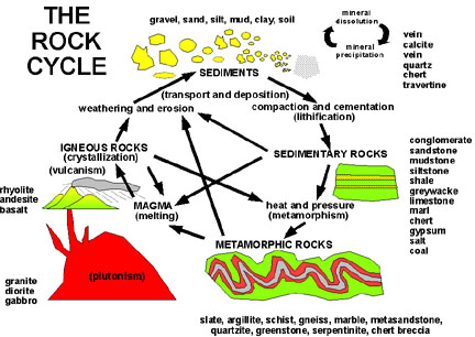
The concept diagram below describes the rock cycle where each of the rock types is related to the others through different physical and chemical processes. For instance, mountains can expose igneous, sedimentary, and metamorphic rocks to weathering and erosion. Grains of sediment (or boulders!) break off of these exposed rocks and are transported downhill either in a stream bed or by rolling. This travel causes further breakdown of the sediment, which eventually reaches the ocean. The sediment, once deposited in an ocean basin, gets buried by other sediments and compacted into sedimentary rock. If it’s buried deeply enough, or if the basin becomes part of an orogen (mountain), it can be metamorphosed, becoming a metamorphic rock. Eventually, the rock can either become exposed through sea level fall or mountain-building, where it starts the journey back to the ocean again, or it can be recycled back into the mantle at a subduction zone, perhaps one day returning to the surface as an igneous rock. The following concept map shows the rock cycle in terms of earth processes. New material forms from mid-ocean ridges and volcanoes; it is weathered, deformed, compacted and cemented, until it is recycled back into the mantle at a subduction zone.
Test your understanding of the rock cycle using the Annenberg Learner website. It's not required, but it is kind of fun!
At this point, you may be thinking to yourself "how does a sedimentary rock, formed in an ocean, get to be in a mountain range? And if rocks are constantly being weathered, extruded, or squashed, shouldn’t the earth be changing constantly?" And you’d be right! The earth is made up of distinct tectonic plates. Where they move towards each other they collide to form mountain belts or one plate goes beneath the other to form a subduction zone, which often creates volcanic activity. Where they move away from each other mid-ocean ridges form, the birthplace of new rock along the ocean floor. These plates move individually and very, very slowly. Sometimes these movements are slow and steady. Other times, the plate gets stuck, and that slow and steady motion builds up over hundreds of years, releasing all at once in a devastating earthquake, like the 2011 Tohoku Oki earthquake in Japan. Events like earthquakes and volcanic eruptions - obvious changes to the earth’s surface - can happen over a matter of minutes or hours, but the recurrence interval of these events can be hundreds to thousands of years.
Check Your Understanding
Take a couple of minutes to watch the video below to learn how plate tectonics, volcanoes, and earthquake are related.
Video: Plate Tectonics (2:42)
The Tonga-Kermadec arc is a chain of volcanoes and volcanic islands extending from Tonga, way up to the north of New Zealand, through the Kermadec Islands, extending down through the north of New Zealand, and eventually arriving offshore at White Island, and then on into the top of the volcanic zone. It's got literally hundreds of volcanoes. The Kermadec islands are really just the tips, the very top of some of these seamounts that have made it to the surface. And it's an active volcanic chain. The theory about why it's there goes back into the relatively new theory in the geology of plate tectonics. And plate tectonics really came to the fore and started to become accepted probably in the early 1960s.
The original idea of continental drift came from Wegener. And he noticed that if you put South America and Africa together they fit very nicely together. One looks like it a reverse template of the other. And so he postulated that originally the continent was together and they drifted apart. It didn't actually explain the dynamics of the world/ It didn't explain why we had big mountain ranges. It didn't explain why you had volcanic arcs. It didn't explain the Ring of Fire of the Pacific. Various theories were popular for a little while. For example, people argued that the earth was expanding, that it was originally a globe covered in continental crust and then if you blew it up like a balloon then the continental crust broke up and bits of it were distributed around the outside.
In about the mid-60s, people began to connect up some ideas. People started to map the oceans and what they recognized was that there was this massive mountain chain that extended all around the world. Then people became aware that as you went away from that mountain range, the crust got older. Then they started to map the magnetics of the ocean and they found that there was a magnetic variability that amounted to magnetic stripes that were parallel to these ridges. And then they were able to link in the fact that there was a ring of fire around the Pacific and that more particularly, all the earthquakes were concentrated around the rim of the Pacific. So eventually somebody had the right idea. Well if you draw a line through all the earthquake activity, you get regions where there's no seismic activity and a lot of the volcanic activity. And so the theory started to come together. And really when it came together, that theory was was the most influential thing that had happened in geology since Darwin's theory of evolution, in terms of changing the paradigm, changing the way people thought about the world.
Did you notice that a majority of earthquakes and volcanic events occur at plate boundaries?
Some old mountains, like the Appalachian Mountains of the eastern United States, show where plate boundaries used to be, but are no longer. As the plates move, where they interact with each other they build up stress and strain. Stress is the push, pull, or shear felt by a material when subjected to a force (in this case, another tectonic plate). Strain is the change in shape due to stress. When enough force builds up, the friction keeping the two plates in place is overcome and the strain energy is released, often all at once, causing an earthquake!
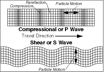
As a result of the sudden release of energy, large waves move through the earth: P-waves, or primary waves; S-waves, or secondary waves, and surface waves. P-waves are compression waves. These waves arrive at detectors first and can move through the entirety of the earth to be recorded by seismic detectors on the far side. S-waves arrive second (as you may have guessed). S-waves are transverse waves and cannot pass through liquid. Careful observations of seismic waves at the far sides of earthquakes are how we know the outer core of the earth is liquid! Surface waves are the slowest of the three, do not penetrate below the crust of the earth, and cause motion at the surface, bringing down buildings and causing damage.