Appalachian Basin Oil and Gas Resources
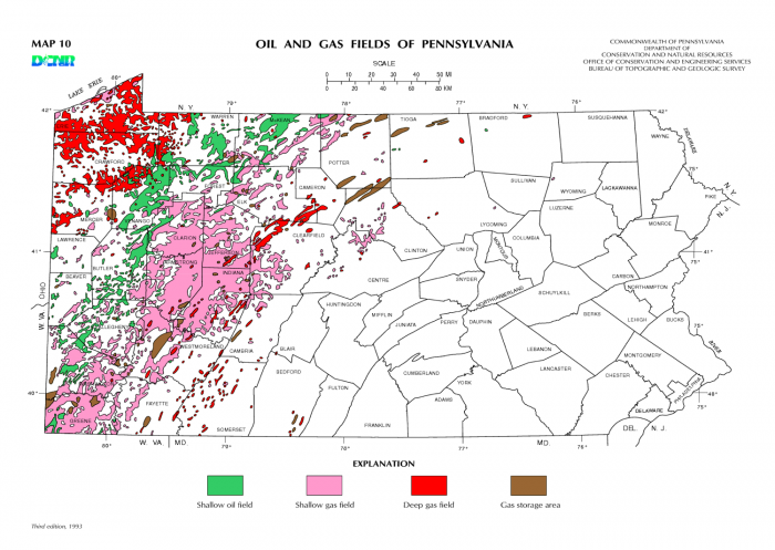
The Appalachian Basin has a long history of conventional oil and gas development, since Col. Edwin Drake's well-hit oil near Titusville, PA in 1859. Since then it has been estimated that upwards of 750,000 oil and gas wells may have been drilled in Pennsylvania alone, with the vast majority of these wells producing from conventional formations. The source of the hydrocarbons for many of these wells is likely a shale, such as the Marcellus shale. The figure below shows the conventional oil and gas fields where most wells have been drilled historically in Pennsylvania, with most of these wells drilled into sandstones and carbonate formations in Western Pennsylvania.
Most drilling occurring in Pennsylvania is currently in the Marcellus shale, a Middle Devonian-age organic-rich formation, which extends in the subsurface from New York State in the north to northeastern Kentucky and Tennessee in the south and is the most prolific natural gas-producing shale in the United States. The formation footprint covers about 95,000 square miles with a prospective area about 72,000 square miles as shown in the map below.
The organic-rich black shale of the Marcellus formation was deposited in a foreland basin roughly paralleling the structural front of the present-day Appalachian Mountains during the Middle Devonian time about 390 million years ago. The Marcellus Shale is described as carbonaceous silty black shale that encloses scattered pyrite, carbonate concretions, and scarce fossils. Several beds of calcareous shale and black limestone and one or more zones of concretions that vary in composition, abundance, and character have also been recognized (Ettensohn and Baron, 1981; Harper, 1999; Roen and Walker, 1996). The Marcellus lithology varies across the Appalachian basin which is controlled by depositional and diagenetic processes, but typically the Marcellus shale is laminated (fissile) and lacks bioturbation.
The Marcellus interval is divided into three members: the lower Marcellus/Union Springs Shale, the middle/Cherry Valley Limestone, and the upper Marcellus/Oatka Creek Shale. The Marcellus exhibits several different pressure regimes across the Appalachian basin. Generally, the Marcellus is under-pressured to the southwest and normal-pressured, to potentially overpressured, to the northeast, with a transitional area in between. Likely, the highest ultimate recoveries will be from the normal to over-pressured areas. The presence of these distinct pressure regimes and variations in lithology requires different approaches to well stimulation and completion.
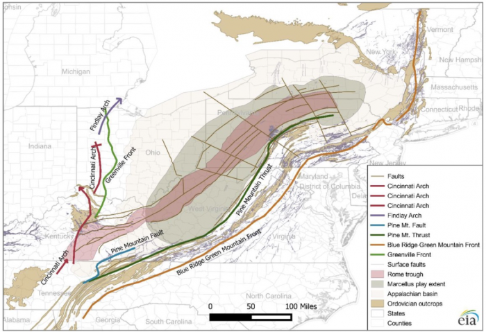
The depositional environment of the Marcellus Shale is in the Appalachian foreland basin which was an enclosed platform-margin sedimentary succession that is dominated by siliciclastic and carbonate sequences of the Early Cambrian age through Early Permian age. The Appalachian basin is an asymmetrical, northeast-trending trough as shown figure below. The basin is bounded by the Blue Ridge Green Mountains front to the southeast and the Cincinnati arch to the northwest and was formed in response to the Alleghanian orogenic event. Major causes of subsidence during Paleozoic were related to tectonic flexure of the lithosphere and sediment loading associated with the rejuvenation of the Appalachian foreland basin. The basement structure of the Appalachian basin, along with major interpreted faults and the projected position of the Rome trough, serve as tectonic features controlling depositional and burial history of the sedimentary formations in the region, including the Marcellus shale. The mapped basement faults fall into two categories: (1) faults that strike parallel to the basin and are associated to the Rome trough, and (2) transform faults that are developed perpendicular to the strike of the basin. The map below shows these major structural features in the area of the Marcellus play.
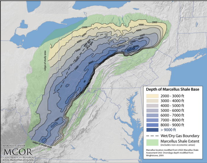
The Marcellus shale occurs as deep as 9,000 feet below ground surface. At greater depths, the overlying rocks cause greater pressure in the Marcellus formation which can result in higher production rates if properly stimulated. In general, with greater depth, the natural gas contains higher proportions of methane and less "wet" gas components, namely propane, butane, and ethane. The boundaries of the Marcellus formation are outlined to the north, south, and east by the outcrop belt of the formation and to the west by the pinching out of the Marcellus by the Middle Devonian Unconformity buried in the subsurface as shown in the depth to Marcellus map below.
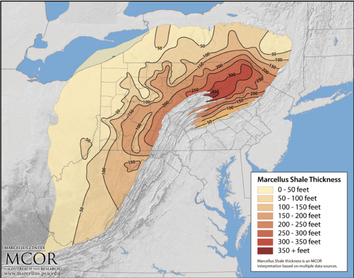
The map below shows the approximate thickness of the Marcellus shale which ranges from less than 25 feet in Western Pennsylvania to greater than 350 feet in Northeastern Pennsylvania. In general, the thicker sections of the shale will be more productive, though in Southwestern Pennsylvania where the shale is less than 100 feet thick has some of the most productive wells in the state due to the in-place content of gas.
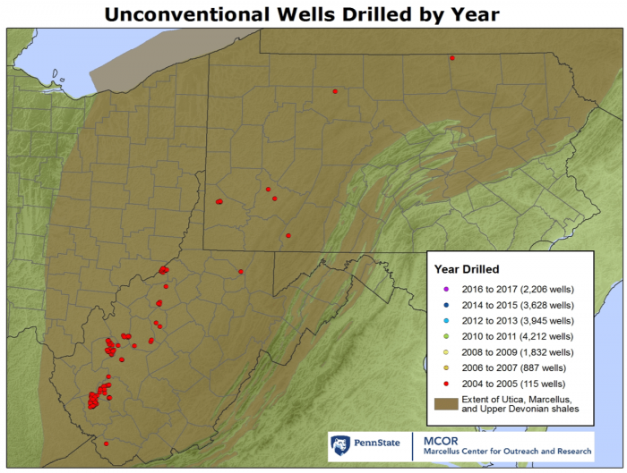
The map below shows the location of shale wells in PA, OH, and WV, where a total of over 17,000 wells have been drilled to date. In Pennsylvania, many of the wells have been drilled in SW or NE Pennsylvania due to the optimal geologic conditions and production. Currently, shale gas production in the Appalachian Basin is producing approximately 25 billion cubic feet of gas per day, approximately one-third of all natural gas produced in the US.