Now that we are experts on Plate Motions, let's think about how Volcanic Island Chains work and how they can help to understand plate tectonics and ocean process.
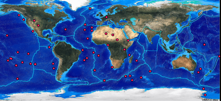
The dots on the map below show locations of major Hotspots on Earth's surface.
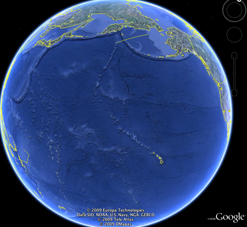
I made the image below with Google Earth. It shows the Hawaiian Island Chain and the Emperor Seamount Chain. Follow the linear track to the northwest from the Hawaiian islands (yellow lines show island coastlines). The features that are not outlined in yellow are below sealevel; they're called seamounts. The Hawaiian chain connects to the Emperor Seamount Chain, which has a more northerly trend. The seamounts are extinct volcanoes. Each one of them was once located over the Hawaiian Hotspot.
Want to learn more?
- More information about hotspots, see "'Hotspots': Mantle thermal plumes."
Hotspots and Ocean Floor Morphology
Hotspot tracks on the ocean floor were one of the first smoking guns for the theory of plate tectonics, and they were also one of the conundrums. Early evidence showed that hotspots were more or less fixed in space; they did not seem to move relative to one another. This led to the idea that they originated at great depth. But how could a narrow plume of heat, or low viscosity material, rise through the convecting mantle without being offset? Early researchers pointed to the analogy of smoke rising through the atmosphere: on a windy day, the smoke plume was offset, and when the wind changed direction, so did the plume.
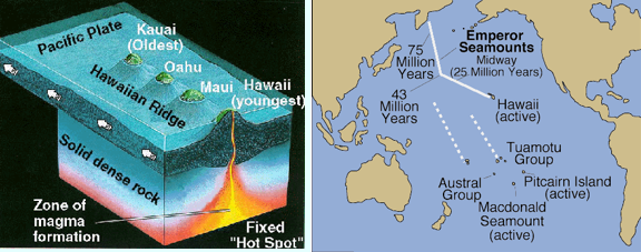
The images below shows a basic idea of how hotspots and linear island chains work.
Activity 3
Directions
- Refer to these short papers:
- Post your responses to the following questions in the discussion area on Canvas for Lesson 2 Activity 3.
- Why do hotspots form distinct volcanic islands, rather than a continuous linear axis?
- What major change occurred recently in our thinking about Hotspots, and what were the data that led people to rethink the way hotspots work?
- Many textbooks say that the change in trend of the Hawaiian Islands and the Emperor Seamounts represented a major shift in the direction of the Pacific plate motion ~ 43 Ma. Is that still thought to be true?
- Read the postings made by other EARTH 540 students.
- Respond to at least two other postings, per question, by asking for clarification, asking a follow-up question, expanding on what has already been said, etc. You should have at least six responses to other postings.
Submitting your work
- I have begun this discussion activity by posting each of the 3 questions to the discussion on Canvas. Please click on the "reply" link that follows each question in order to post your response. To respond to another student's posting, use the "reply" link that follows their posting.
Grading criteria
You will be graded on the quality of your participation. See the grading rubric for specifics on how this assignment will be graded.