Living on an Island: Origin of Ocean Basins and Sea Floor Morphology
About Lesson 2
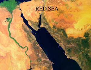
In one sense or another, we are all Living on an Island. The continents are buoyant rock masses that are floating in the Earth’s mantle-asthenosphere and surrounded by water at the surface. Earth’s surface is in constant motion and the ocean basins are continually evolving. The image of the Red Sea on this page is an example of some of the most recent change—an ocean basin is forming! We’re going to spend Lesson 2 exploring the Origin of the Ocean Basins and learning about how Sea Floor Morphology relates to the processes that have shaped the current ocean geometry. As I suspect you know, this all starts with Plate Tectonics and Sea Floor Spreading.
By the end of this lesson you should have a deeper understanding of: plate geometry and kinematics, the role of earthquakes, hot spots and how they relate to volcanic edifices, and continental margins. One of the things to think about this week is how you might develop a teaching module on Plate Tectonics.
What will we learn in Lesson 2?
By the end of Lesson 2, you should be able to:
- Explain the basic tenets of plate tectonics including relative and absolute plate motion.
- Use spherical trigonometry to calculate linear and angular distances on Earth’s surface. Employ this knowledge to work with plate motion vectors
- Use on-line resources to calculate rates of plate tectonic motion.
- Explain hot spots at a basic and sophisticated level, including how they can be used to determine relative plate motion, past theories of their origin, the concept of “Mantle wind,” and current ideas about their origin.
- Describe the Wilson Cycle and related concepts of Sea Floor Spreading.
- Discuss Earth’s internal structure, including the relationship and distinctions between chemical classifications (Crust, Mantle, etc.) and rheologic classifications (Lithosphere, Asthenosphere…).
- Readily point out examples of the three basic plate boundaries and their tectonic, seismic and volcanic manifestations at Earth’s surface.
- Use on-line resources to construct maps of the ocean floor
What is due for Lesson 2?
The chart below provides an overview of the requirements for Lesson 2. For assignment details, refer to the lesson page noted. Due dates are listed in this table and in Canvas.
| REQUIREMENT | LOCATION | SUBMITTED FOR GRADING? |
|---|---|---|
| Activity 1: In five easy parts... | see "activity 1" in lesson 2 menu | Yes - You should put a file with your answers in the Canvas dropbox, due June 16th |
| Activity 2: Make map images and comment in a discussion forum. | see "activity 2" in lesson 2 menu | Yes- You should put a file with your answers and comments in the Canvas dropbox |
| Activity 3: Hotspots, background reading and discussion | see "activity 3" in lesson 2 menu | Yes- Discussion responses will be graded. |
Questions?
If you have any questions, please post them to our Questions? discussion forum (not e-mail), located in the Discussions menu in Canvas. I will check that discussion forum daily to respond. While you are there, feel free to post your own responses if you, too, are able to help out a classmate.