Using the broadest definition of remote sensing, there are innumerable types of platforms upon which to deploy an instrument. Discussion in this course will be limited to the commercial platforms and sensors most commonly used in mapping and GIS applications. Satellites and aircraft collect the majority of base map data and imagery used in GIS; the sensors typically deployed on these platforms include film and digital cameras, light-detection and ranging (lidar) systems, synthetic aperture radar (SAR) systems, multispectral and hyperspectral scanners. Many of these instruments can also be mounted on land-based platforms, such as vans, trucks, tractors, and tanks. In the future, it is likely that a significant percentage of GIS and mapping data will originate from land-based sources; however, due to time constraints, we will only cover satellite and aircraft platforms in this course.
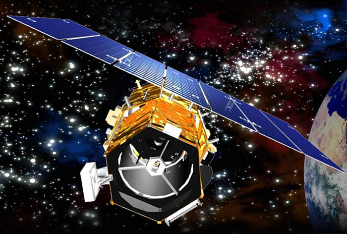
Since the launch of the first Landsat in 1972, satellite-based remote sensing and mapping has grown into an international commercial industry. Interestingly enough, even as more satellites are launched, the demand for data acquired from airborne platforms continues to grow. The historic and growth trends for both airborne and spaceborne remote sensing are well-documented in the ASPRS Ten-Year Industry Forecast![]() . The well-versed geospatial intelligence professional should be able to discuss the advantages and disadvantages for each type of platform. He/she should also be able to recommend the appropriate data acquisition platform for a particular application and problem set. While the number of satellite platforms is quite low compared to the number of airborne platforms, the optical capabilities of satellite imaging sensors are approaching those of airborne digital cameras. However, there will always be important differences, strictly related to characteristics of the platform, in the effectiveness of satellites and aircraft to acquire remote sensing data.
. The well-versed geospatial intelligence professional should be able to discuss the advantages and disadvantages for each type of platform. He/she should also be able to recommend the appropriate data acquisition platform for a particular application and problem set. While the number of satellite platforms is quite low compared to the number of airborne platforms, the optical capabilities of satellite imaging sensors are approaching those of airborne digital cameras. However, there will always be important differences, strictly related to characteristics of the platform, in the effectiveness of satellites and aircraft to acquire remote sensing data.
One obvious advantage satellites have over aircraft is global accessibility; there are numerous governmental restrictions that deny access to airspace oversensitive areas or over foreign countries. Satellite orbits are not subject to these restrictions, although there may well be legal agreements to limit distribution of imagery over particular areas.
The design of a sensor destined for a satellite platform begins many years before launch and cannot be easily changed to reflect advances in technology that may evolve during the interim period. While all systems are rigorously tested before launch, there is always the possibility that one or more will fail after the spacecraft reaches orbit. The sensor could be working perfectly, but a component of the spacecraft bus (attitude determination system, power subsystem, temperature control system, or communications system) could fail, rendering a very expensive sensor effectively useless. The financial risk involved in building and operating a satellite sensor and platform is considerable, presenting a significant obstacle to the commercialization of space-based remote sensing.
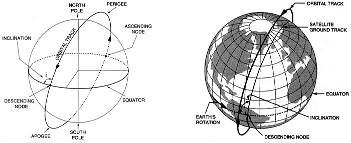
Satellites are placed at various heights and orbits to achieve desired coverage of the Earth's surface. When the orbital speed exactly matches that of the Earth's rotation, the satellite stays above the same point at all times, in a geostationary orbit. This is useful for communications and weather monitoring satellites Satellite platforms for electro-optical (E/O) imaging systems are usually placed in a sun-synchronous, low-earth orbit (LEO) so that images of a given place are always acquired at the same local time (Figure 2.02). The revisit time for a particular location is a function of the individual platform and sensor, but generally, it is on the order of several days to several weeks. While orbits are optimized for time of day, the satellite track may not always coincide with cloud-free conditions or specific vegetation conditions of interest to the end-user of the imagery. Therefore, it is not a given that usable imagery will be collected on every sensor pass over a given site
Aircraft often have a definite advantage because of their mobilization flexibility. They can be deployed wherever and whenever weather conditions are favorable. Clouds often appear and dissipate over a target over a period of several hours during a given day. Aircraft on site can respond with a moment's notice to take advantage of clear conditions, while satellites are locked into a schedule dictated by orbital parameters. Aircraft can also be deployed in small or large numbers, making it possible to collect imagery seamlessly over an entire county or state in a matter of days or weeks simply by having lots of planes in the air at the same time.
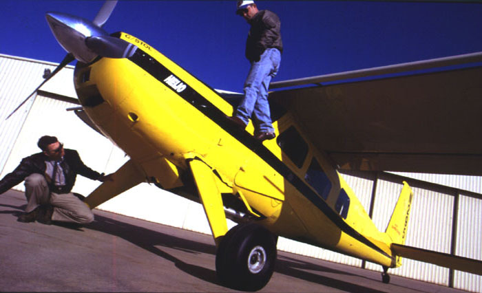
Aircraft platforms range from the very small, slow, and low flying (Figure 2.03), to twin-engine turboprop and small jets capable of flying at altitudes up to 35,000 feet. Unmanned platforms (UAVs) are becoming increasingly important, particularly in military and emergency response applications, both international and domestic. Flying height, airspeed, and range are critical factors in choosing an appropriate remote sensing platform, and you will learn about this in more detail later in the lesson. Modifications to the fuselage and power system to accommodate a remote sensing instrument and data storage system are often far more expensive than the cost of the aircraft itself. While the planes themselves are fairly common, choosing the right aircraft to invest in requires a firm understanding of the applications for which that aircraft is likely to be used over its lifetime.
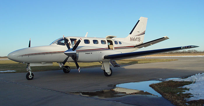
The scale and footprint of an aerial image is determined by the distance of the sensor from the ground; this distance is commonly referred to as the altitude above the mean terrain (AMT). The operating ceiling for an aircraft is defined in terms of altitude above mean sea level. It is important to remember this distinction when planning for a project in mountainous terrain. For example, the National Aerial Photography Program (NAPP) and the National Agricultural Imagery Program (NAIP) both call for imagery to be acquired from 20,000 feet AMT. In the western United States, this often requires flying much higher than 20,000 feet above mean sea level. A pressurized platform such as the Cessna Conquest (Figure 2.04) would be suitable for meeting these requirements.
With airborne systems, the flying height is determined on a project-by-project basis depending on the requirements for spatial resolution, GSD, and accuracy. The altitude of a satellite platform is fixed by the orbital considerations described above; scale and resolution of the imagery are determined by the sensor design. Medium-resolution satellites, such as Landsat, and high-resolution satellites, such as GeoEye, orbit at nearly the same altitude, but collect imagery at very different ground sample distance (GSD).
1 Sun-Synchronous Orbit. (2007, November 27). On Wikipedia, The free encyclopedia. Retrieved December 4, 2007, from http://en.wikipedia.org/wiki/Sun-synchronous_orbit