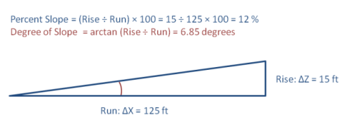
Slope is the steepness or the degree of incline of a surface. Slope cannot be computed from the lidar points directly; one must first create either a raster or TIN surface. Then, the slope for a particular location is computed as the maximum rate of change of elevation between that location and its surroundings. Slope can be expressed either in degrees or as a percentage. Aspect is the orientation of slope, measured clockwise in degrees from 0 to 360, where 0 is north-facing, 90 is east-facing, 180 is south-facing, and 270 is west-facing.
Hillshading is a technique used to visualize terrain as shaded relief, illuminating it with a hypothetical light source. The illumination value for each raster cell is determined by its orientation to the light source, which is based on slope and aspect. In the lab activity, you will experiment with placement of the light source, but, for now, it will suffice to say that positioning the light source in the northwest works best to simulate a natural landscape to the human eye. Depending on your application, you might also want to simulate the true position of the sun at a particular date and time of year.