Module 1: State College Borough Water Authority
A. Download the Lesson Data
My story:
The State College Borough Water Authority (SCBWA) serves approximately 65,000 customers in seven municipalities and has about 220 miles of mains. The Authority is not yet using GIS, but is aware of the benefits and costs of a GIS conversion. They have talked to consultants and are starting on a few small projects involving GIS. The Authority has a fairly common story to tell. They have CAD data and paper maps. There are some employees who have worked for the Authority for 25 years who don't even need to refer to the paper maps when responding to a call. At this point in time, starting from scratch and GPSing all features, as one firm suggested, is not an option for the Authority; the cost is too great. They do, however, realize that there are a lot of basemap data freely available at the local and county authority levels, so they wouldn't actually be starting from scratch.
Currently, the Authority's maps just show valve locations and line sizes. Updates are sent to an engineer located in a nearby city. Updates are only made once every two years. The Authority gets about 300-350 "locates" a month, in which Pennsylvania One-Call asks them to locate a line. They also have to go out and work on a line approximately 100 times a month. The design stage for a new development project can take up to a month because they have to wait on other utilities to mark their lines. Therefore, having just the water system in a GIS would not make all jobs much more efficient. The sewer authority has their system in GIS, so the water authority can look to them as an example of what the costs and benefits might be.
The Authority has come up with a list of mapping layers that would be beneficial to them:
- Streets (part of county basemap)
- Property Lines (part of county basemap)
- House Footprints (part of county basemap)
- Elevation Contour Lines (part of county basemap)
- Well Fields
- Storage Tanks
- Pump Stations
- Reservoirs
- Water Treatment Plants
- Water Lines with Valves (including line size, date of installation, length of pipe, date of repairs etc.)
- Fire Hydrants (including hydrant number, flow data with date, manufacturer and model number, etc.)
User Needs Assessment
A User Needs Assessment is a job identification methodology common in Information and Database Technologies. The task of an assessment is to identify end products that the user needs to perform the tasks. The methodology does not need to be identical as long as all the required tasks can be performed. Often it attempted to speed up all tasks through some form of automation. You can see how GIS fulfills that role. If this can be done, all well and good, however, often there is a trade off and common tasks can be expedited at the cost of a more unusual task. Formally, a User Needs Assessment starts with identifying all the procedures and data required to perform all of the tasks as they are done now. Next, automation of the most common tasks is sought. This can be done through technology, better information utilization through better data structures, storage, and retrieval. Frequently, these improvements take the form of automatic data lookup, e.g., returning the location coordinates for a GPS, and an address upon click on a point. In this way, forms can be filled out with minimum of end user input. Next, the rarer tasks are looked at and prioritized according to length of time they take and the frequency they are performed. Finally, any security or procedural upgrades are investigated. Often it is better to introduce these later as it cuts down on the re-training component and staff resentment. However, if they are to be deferred, the data structures need to be in place to facilitate future upgrades. When you start your own problem, think about the end results that users will require. (In real-life these are very complex, but this will give you an idea how they are constructed.)
Infrastructure Maintenance
Locations and line sizes.
Data: Infrastructure position, Pipelines and Valves as lines and points, Attributes: size , pipe type, date of installation, length of pipe, date of repairs etc., Projection, Datum.
Location Services
The Authority gets about 300-350 "locates" a month, for Pennsylvania One-Call.
Data: Infrastructure positions, Property Lines, Building Lines and Footprints as Lines and Polygons, Projection, Datum..
Line work approximately 100 times a month.
Data: Infrastructure Location, Property Information, Work Order No. Work Required, Equipment and Parts Required, Projection, Datum.
Threat avoidance
The sewer authority has their system in GIS, so the water authority can use this to identify contamination problems.
Data: Storage Tanks, Pump Station, Well Fields, Sewage Company Data, Projection, Datum., Distance to Sewer from Well Head, Sewer Line to Pipe Line Junction Distance , Uphill or Down Hill, etc.
Code Compliance
Ensure that buildings are adequately covered by Fire Hydrants.
Data: House Lines and Footprints, Fire Hydrants Location and Attributes (including hydrant number, flow data with date, manufacturer and model number, etc.), Number of houses in fire hydrant service radius, required Flow Rate, Projection, Datum.
I contacted the engineer who updates and maintains the Authority's data and requested a portion of the service area. It is usually easier to convince someone to share data when the use is for "education purposes only." Agreeing to share data inevitably means that you are agreeing to answer questions about those data that you may or may not know the answer to. The data I originally acquired from the firm were CAD data. After a conversation with the engineer about why I wanted the data, he indicated that he did have the same data converted into shapefiles. He converts the data from CAD to GIS for mapping purposes. In this activity we will look at the CAD data provided.
I also acquired basemap data from Centre County. This data is available for public use. I met with the County director and he provided me with a CD of the data. We will look at a few of the county layers, which have been clipped to the extent of the SCBWA Pine Grove Mills Service Area.
Registered Students download from ANGEL the Lesson 1 data (lesson1files.zip) to a new folder (e.g., C:\MGIS\GEOG488\Lesson1).
The data in this exercise are used by permission of the State College Borough Water Authority and the GIS Director of Centre County, Pennsylvania. I want to thank the Centre County GIS Director, Steve Albright of the Water Authority, and Jeff Sergeant of Gwin, Dobson & Foreman Inc.
B. View the Data in Safe Data Inspector or ArcCatalog and ArcMap
- From the above description, write a brief User Needs Assessment Statement, e.g. Location, Identification etc.
- Unzip the files for lesson 1.
- You need FME for this lesson. If you have not already obtained it, obtain it now. See Orientation Lesson for instructions. Otherwise, you can use ArcCatalogue and ArcMap.
- Start Universal Viewer, ArcMap, and ArcCatalog.
- Start FME Universal Viewer to view the SCBWA (State College Borough Water Authority) data; under file menu use the open dataset. Support for the Safe Software FME is through the course instructor and not through Safe Software or World Campus.
- Set Format to Autocad Drawing in the format gallery and take the time to scroll up and down the list to realize how daunting format change is in GIS. There are hundreds of data types in this list.
- Navigate to the Autocad Drawing on your computer.
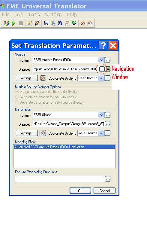
- Use the information button with an "I "on it to look at some of the details. Here is an example: Autocad drawing in Universal Viewer Figure 1. You can use the button with three dots to navigate Figure 2.
- Now open the Centre data Street data in the same way. Do not forget to set data type to Esri shape file in the format gallery. Here is an example, Shapefile in Universal Viewer Figure 2.
- In ArcCatalog, view the SCBWA (State College Borough Water Authority) data. You'll notice that the data are represented two ways: as a CAD drawing file and as a CAD feature dataset. The drawing file should be used for display only and the feature dataset should be used for display and geographic analysis. Now look in Safe Universal Viewer.
- Preview each representation. You'll see that the drawing file is using symbology as defined in the CAD file (features are represented with different colors.)
- Add both the drawing file and the feature dataset to ArcMap.
- Check out the Data Frame Properties of the data. Take a look at the Coordinate System. The data aren't projected.
- Now take a look at the attribute table for one of the feature datasets. Without being very familiar with this data set or having an extensive data dictionary, the fields and records are fairly cryptic. After talking to the Authority's engineer, I was able to make a look-up table for the lines.
- Add the layer_descrip lookup table to your map document and join it to the polyline feature dataset. This additional information might make it a bit easier to symbolize the layer.
- Imagine that you want to edit these data. You can select certain features and create shapefiles or personal geodatabases from them. Let's create a roads shapefile. Select all the features that meet these criteria: "Layer" = 'ROAD_CL' OR "Layer" = 'PADOT_CL'
- Export those features to a shapefile called "roads."
- Add a new data frame and add the Centre County data.
- If you look at the streets_cl layer, you can see where the two datasets would come together, even though the roads shapefile created from the CAD data has gaps in it.
How can we integrate these data sources?
Does the county coordinate efforts with the water authority on standards and interoperability? These are just a couple of questions we need to address. - We'll work with these CAD data again in Lesson 5/6, when we'll georeference them so we can overlay them with the Centre County basemap data.
C. Save Your Map Document
Click the Save button on the Standard toolbar or click the File menu and choose Save.
That's it for Part I!
You have just completed Part I of this module, which involved looking over some data provided by a water authority. In Part II, you will start a GIS assessment for your local area.