A. Download the Lesson Data
Susan's story:
Susan is a former student in the Certificate Program in GIS. Susan decided to create a GIS activity for children in a local middle school. She picked a topic that fit well with the curriculum and that is of interest to her - volcanoes in Montserrat, British West Indies. She had no data resources when she started the project and decided to search online resources and data clearinghouses.
Optional Exercise: Registered Students can download from ANGEL the Lesson 3 data (optional.lesson3files.zip) to a new folder (e.g., C:\MGIS\GEOG488\Lesson3) and look at real world examples of data mismatch.
I want to thank Susan Wheeler for the contribution of her story.
B. Look at the Data Susan Acquired
Susan has also contributed to the profession by educating others about GIS. I decided to include her story in this lesson because she did an exhaustive search of online resources. She acquired some georeferenced data and digital maps from the web, but discovered that she would probably have to create her own data to make a worthwhile activity. She searched a local library, found a topographic map, scanned it, georeferenced it and digitized layers necessary for her project.
Susan's task was fairly different from what we are doing. She was at a disadvantage because she was looking for data for a place that doesn't have much, but she was at an advantage in that she was working with an entire island and didn't have to have any large scale data to make her project work.
Susan provided a list of resources she used.
The types of data found in most clearinghouses free of charge are usually more suitable for projects like Susan's because she did not need the level of accuracy that we are more likely to need in our projects. She was working at a much smaller scale; she was looking at data for an entire island. Susan was amazed at the amount of searching she had to do to acquire such a small amount of data. Without doing that search though, she wouldn't have known that the data she needed didn't exist (not that she was able to find anyway).
Here is an image showing some of the data Susan acquired.
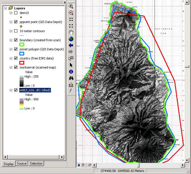
I should mention that this project did not only involve a search for data on the web. Susan and her family went to Montserrat (a research trip that was to take place regardless) and collected GPS data that were used in the lesson. After her Internet searches, which led to some phone calls and emails, she was fairly confident that the data she created were not part of a duplicated effort. Susan's work paid off. The kids learned GIS through a fun and interactive lesson and she was able to reach an even greater audience by writing about the experience. See an article about Susan's work entitled "Exploring Montserrat, British West Indies, With GIS" in ArcNews.
C. Data for your project
Acquire Data from Clearinghouses for Your Project Area
Your story:
As part of your assessment in week 1, you might have discovered that there are online resources, such as a state clearinghouse, that have data for your project area. Perform an Internet search and compile a list of sites that contain data that might be useful for your data inventory.
Websites that provide geospatial data or links to them are popping up all over the place. It's interesting to see what the latest and greatest idea is when it comes to clearinghouses. Over the past years, we've seen quite a few clearinghouses touting themselves as a place for "one-stop shopping." The most recent, Geospatial One-Stop, even includes that in the name. How can you question that? The truth is, whether it's FDGC's Clearinghouse, or Esri's Geography Network, or the National Map and Geospatial One-Stop, most of these organizations seem to have trouble with buy-in.
Different sites have different requirements for contributors, but a good site requires complete metadata. As you likely discovered in Lesson 2 (if you weren't already aware), good metadata are hard to come by. Most organizations haven't made metadata a priority and are therefore unlikely to make the time to prepare data so they are publishable. There are also the many questions that people have. What is the quality of the data? Who can (should be allowed to) contribute? How often to I have to publish updates? What's in it for me? This last question is probably the biggest. The newest portals are so new that they may still prove themselves to be one-stop shops. It seems that GIS professionals like us should be contributing our own data to those sites.
As you're creating your list of resources, keep these questions in mind:
- Is the online source made available by the government? Is it a local, state, or national initiative?
- Are the data free of charge?
- Are there any requirements for data standards or metadata standards?
- Do the data reside on the site or is the site a portal to other sites?
- Are users encouraged to publish their own data?
That's it for Part I!
You have just completed Part I of this module, which involved perusing some data I acquired from clearinghouses and pondering legal and ethical issues related to GIS. In Part II, you will browse clearinghouses to look for data for your project area.