Spatial data is special and can be problematic. However, as we will see later in this course, there are instances when this can be useful, so understanding how we deal with it is important.
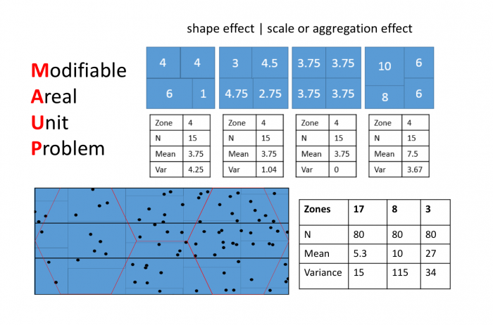
Figure 1.0. Modifiable Areal Unit Problem
Credit: Blanford, © Penn State University, licensed under CC BY-NC-SA 4.0
Learning Outcomes
By the end of this lesson, you should be able to:
- List four major problems in the statistical analysis of geographic information: autocorrelation, the modifiable areal unit problem, scale dependence, edge effects.
- Identify and discuss the implications of the Modifiable Areal Unit Problem.
Checklist
Lesson 1 is one week in length. (See the Calendar in Canvas for specific due dates.) The following items must be completed by the end of the week. You may find it useful to print this page out first so that you can follow along with the directions.
| Step | Activity | Access/Directions |
|---|---|---|
| 1 | Work through Lesson 1 | You are in the Lesson 1 online content now. Be sure to carefully read through the online lesson material. |
| 2 | Reading Assignment | Before we go any further, you need to complete the reading from the course text plus an additional reading from another book by the same author:
|
| 3 | Weekly Assignment | Examine the Modifiable Areal Unit Problem while analyzing voting results |
| 4 | Term Project | Post term-long project topic idea to the project topic discussion forum in Canvas. |
| 5 | Lesson 1 Deliverables |
|
Questions?
Please use the 'Discussion Forum' to ask for clarification on any of these concepts and ideas. Hopefully, some of your classmates will be able to help with answering your questions, and I will also provide further commentary where appropriate.