Speaker
Our next webinar will be with Mr. Michael Ratcliffe. Michael is Assistant Division Chief for Geographic Standards, Criteria, Research, and Quality in the Census Bureau’s Geography Division, where he is responsible for geographic area concepts and criteria, address and geospatial data quality, and research activities. During his tenure at the Census Bureau, he has worked in both the Geography and Population Divisions, on a variety of geographic area programs, including urban and rural areas, metropolitan and micropolitan statistical areas, and other statistical geographic areas, and has led staff engaged in product development and dissemination. In addition to his work at the Census Bureau, he is an adjunct professor at George Washington University, where he teaches Population Geography. Prior to that appointment, he was an adjunct instructor at the University of Maryland-Baltimore County. Mr. Ratcliffe holds degrees in geography from the University of Oxford and the University of Maryland.
Geographic Areas Used by the Census Bureau
The Census Bureau defines many different geographic areas which can be used to organize and aggregate data. The areas the Census Bureau uses can be divided into those which are legally defined and those which are not. The Census Bureau refers to non-legally defined areas as statistical areas.
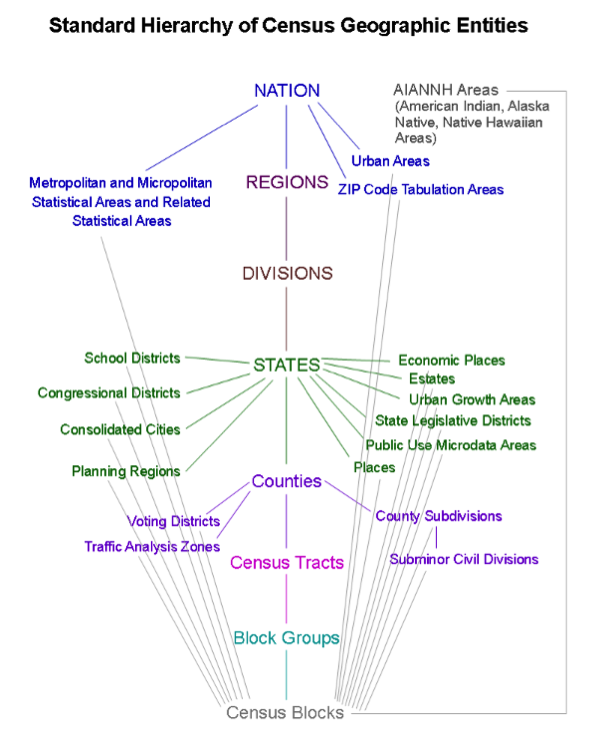
Nation
Metropolitan and Micropolitan Statistical Areas and Related Statistical Areas
Urban Areas
ZIP Code Tabulation Areas
Regions
Divisions
States
School Districts
Congressional Districts
Consolidated Cities
Planning Regions
Economic Places
Estates
Urban Growth Areas
State Legislative Districts
Public Use Microdata Areas
Places
Counties
Voting Districts
Traffic Analysis Zones
County Subdivisions
Subminor Civil Divisions
Census Tracts
Block Groups
Census Blocks
AIANNH Areas (American Indian, Alaska Native, Native Hawaiian Areas)
Metropolitan and Micropolitan Statistical Areas and Related Statistical Areas
Urban Areas
ZIP Code Tabulation Areas
School Districts
Congressional Districts
Consolidated Cities
Planning Regions
Economic Places
Estates
Urban Growth Areas
State Legislative Districts
Public Use Microdata Areas
Places
Voting Districts
Traffic Analysis Zones
County Subdivisions
Subminor Civil Divisions