GIS and other geospatial technologies can support a key element of disaster preparation through computational simulation and modeling. A wide array of specialized modeling software extensions for ArcGIS and other GIS platforms are available. This software enables users to tweak disaster parameters and simulate damage patterns due to storms, earthquakes, disease outbreaks, and fires (think back to InaSAFE from the previous lesson). With the rise of cloud computing, near-real-time data streams, and big data analytics, much of this happens at a fast pace including analysis well before the event up to the start of the event itself. For example, thinking about the preparations for Hurricane Florence and how often decisions on pre-deploying assets changed as new information became available to the managers. This will become clearer when we consider disaster and humanitarian logistics later in this lesson.
The output of these models can be viewed in static maps or interactive web tools. Some real-time modeling capabilities exist for emergency managers to test various parameters and visualize their potential impact, but few of these systems are available for free to the general public (very unfortunate!). The Pacific Disaster Center in Hawaii does quite a lot of work on modeling and visualizing model outputs for disaster scenarios. Have a closer look at this site and some of the tools and apps PDC offers, including the disaster preparedness training.
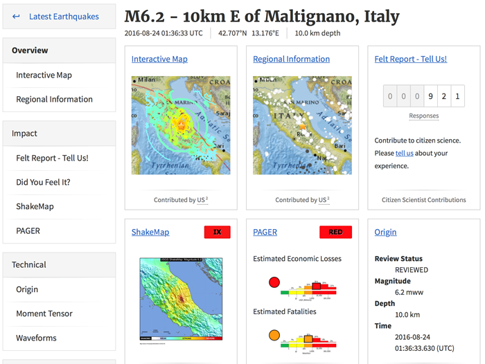
One publicly available resource is provided by the USGS in the form of their Prompt Assessment of Global Earthquakes for Response (PAGER) system. PAGER provides rapid reporting on the potential impacts of recent earthquakes on human life and structures in easy-to-consume reports and maps.
Note
You may want to refer back to some of these resources (and find others!) as potential sources of data for your term project and the case study assignments coming later in this course.