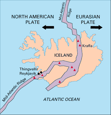
Iceland is unique in that it is the only place in the world where a mid-ocean ridge protrudes above sea level. Iceland straddles the Mid-Atlantic Ridge, with the North American Plate to the west and the Eurasian Plate to the east, and ~2 cm/yr relative motion in opposing directions. Much, although probably not all, of the magmatism at Iceland is a result of mantle decompression beneath this divergent plate boundary.
Mantle Convection and Plate Tectonics
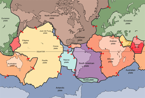
In Module 1, we learned that tectonic plates move across Earth’s surface relative to a more or less fixed reference frame of mantle plumes. So what are these plates, and why do they move? The Earth’s lithosphere – which consists of the crust and the rigid upper portion of the mantle – is broken up into 15 major plates, plus several micro-plates. The tectonic plates move with respect to one another – some moving apart at divergent boundaries, some coming together at convergent boundaries, and some sliding past each other at transform boundaries. The lithospheric plates ride on top of the flowing, plastic mantle asthenosphere.
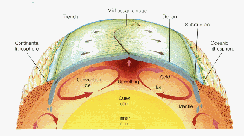
The geothermal gradient inside the Earth is such that temperature increases with depth. The higher temperatures at the core-mantle boundary (~2,900 km depth) relative to the lithosphere-asthenosphere boundary (~100-200 km depth) drive convection in the plastic, flowing asthenosphere. This works very similarly to water convecting in a pot that’s being heated on the stove – hot fluid is less dense and therefore it rises, while the dense cooler fluid sinks. Just remember that the “fluid” in the mantle is actually a flowing solid; it is more viscous and flows much more slowly than water in a pot – at a rate of millimeters per year. Most geoscientists agree that there is a close relationship between mantle convection and plate tectonics, although it remains unclear to what extent the convecting mantle “drags” the lithospheric plates along its surface, or if instead the sinking of lithospheric plates at subduction zones serves to initiate convection cells in the mantle. In the most general sense, we can imagine that tectonic plates move away from each other at places where the mantle is rising, and together at places where the mantle is sinking.
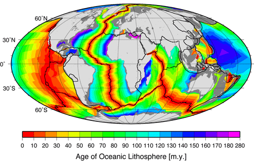
New oceanic crust is more or less continuously being formed at mid-ocean ridges, which are a type of divergent plate boundary. It was mentioned above that the North American and Eurasian plates are moving away from each other at ~2 cm/yr at Iceland. As it turns out, this is a pretty representative average spreading rate for the Mid-Atlantic Ridge, which means that if you were to fly from John F. Kennedy International Airport in New York to London’s Heathrow Airport today, the trip would be 1 meter longer than if you had taken the same flight 50 years ago!
Check Your Understanding
Question 1 - Short Answer
The central Pacific Ocean is spreading at a rate of ~5 cm/yr. How many years does it take for the distance between Mexico City and Hawaii to increase by 1 meter?
Click for answer.
20 Years
Question 2 - Short Answer
Now let’s scale it up to geologic timescales. At a spreading rate of 5 cm/yr, how much would the distance between Hawaii and Mexico City increase in 100 million years? Give your answer in kilometers.
Click for answer.
5,000 km
Question 3 - Multiple Choice
How does this distance compare to the distance between New York and Los Angeles?
Click for answer.
a little bit more - about 1.25 times as far.