Earthquakes and Structural Failures
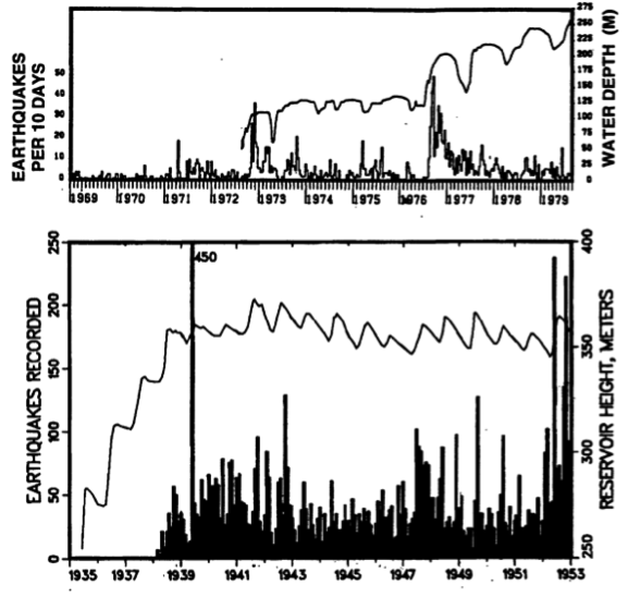
Impoundment of water behind major dams changes the distribution of stress in the Earth’s crust, and in combination with downward percolation of impounded water, can trigger seismicity. For the most part, this phenomenon is restricted to increased numbers of small (magnitude <3.5) earthquakes triggered by the increased load of millions of m3 of water, associated warping – or flexure – of the crust, and diffusion of water pressure from the reservoir along fractures and fault lines (Figure 10). Although hotly debated, reservoir-induced seismicity has even been invoked as a possible mechanism for the devastating 2008 magnitude 7.9 Wenchuan earthquake that killed an estimated 80,000 people (see one news article discussing this issue here). The reservoir impounded behind the 156 m-tall Zipingpu Dam lies above the Beichuan- Yinxiu fault, which extends to the Northeast to the earthquake hypocenter, located ~50 km away.
Although remote, there is also a potential risk of dam failure to life and property downstream. In some cases, the causes of such failures are not known with much certainty. For example, the collapse of the St. Francis Dam Northeast of Los Angeles in 1928 resulted in the catastrophic release of over 12 billion gallons of water. The flood wave, which was over 140 feet high, killed an estimated 600 people and scoured the valley below, transporting fragments of the dam as large as 10,000 tons for almost a mile downstream. In other cases, upstream flooding or inadequate ability to release water and relieve pressure on the dam are the culprit, as in the famous collapse of the South Fork dam and resulting 1889 Johnstown PA flood that killed over 2000 people and triggered changes to liability laws in the U.S. In 1986, a similar disaster at the Glen Canyon Dam was narrowly avoided.