
Now that we know earthquakes and volcanoes are the biggest sources of tsunamis, let's find on a map of the world where these tsunamigenic danger zones are located.
Activity
Note:
You do NOT need to submit the following activity, but doing it will help you visualize where the greatest potential tsunamigenic areas are on the globe. This will aid your thinking about your culminating assignment for this lesson.
Directions
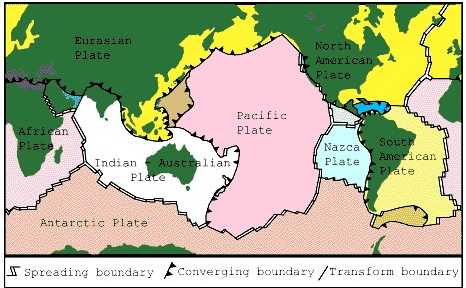
- Print out the world map below by clicking on it and printing the resulting window. This map has the three types of plate boundaries marked on it.
- Remembering that water and vertical motion are the essential ingredients for tsunamis, find the convergent plate boundaries adjacent to oceans and you've found the most likely sources for tsunamigenic earthquakes. Mark these plate boundaries on your map.
- Now, look at the world map below. It has plate boundaries (black lines) and active volcanoes (red dots) plotted on it. On your map that you have printed out, mark the locations of active volcanoes near oceans. I hope you observe that these potentially tsunamigenic locations we have just found are NOT randomly distributed across the globe. In fact, the potential earthquakes and volcanoes are likely to occur near each other. This is not a coincidence. At convergent margins, one plate is forced to subduct below the other. This process is accompanied by both earthquakes and volcanism. The sticking and slipping as one plate dives into the mantle generates earthquakes. Partial melting of the lithosphere of the subducting plate and overriding plate produces a line of volcanoes inboard and roughly parallel to the subduction plate boundary.
- Observe your map and think about the following:
.gif)
- Which of the world's coastlines are most at risk for tsunamis? Does this shed light on where today's tsunami warning systems exist already?
- What tsunamigenic sources would affect the Atlantic coastlines? Where are they located?
Submitting your work
There is nothing to submit for this assignment. However, feel free to post any questions or thoughts you may have about this activity to the Questions? Discussion Board in Canvas.