You can use Google Earth to explore your own digital map of water depths like the one above. Just download a file at NOAA's NCEI Bathymetry site and, once downloaded, select the ".kmz" file. Files are quite large, but very elucidating (try to find something near your house or favorite beach!).
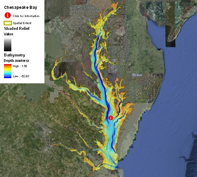
Note the deepest value of nearly 53 meters in the estuary above. Why do the deeper channels tend to hug the east side of the estuary? Is this Coriolis?
In this portion of Lesson 5, we will examine one role of sea level rise in coastal evolution--that of the formation of estuaries. Of course, estuaries are an important feature of the coastal region because they provide water routes to inland regions for shipping, defense, etc., and because they are typically nurseries for the larvae and immature stages of many marine organisms as well as being important fisheries. In this course we will concentrate on the Chesapeake Bay estuary because of its proximity to most of the class and importance to the economy of the mid-Atlantic region. Those in University Park, PA have a direct connection to the Chesapeake because they live in the Susquehanna River watershed which ultimately dumps into the Chesapeake Bay. We'll begin here with a study of the formation of this estuary, and in subsequent lessons we will explore the ecosystem itself and the problems it faces now.
Reading
Click on the links below to access a scientific article on the origin of Chesapeake Bay. Read this paper and think about the evidence that these scientists use to reconstruct the early history of this estuary and the timing and impact of sea level changes. Note the importance of the 8.2 thousand year "event."
Activity 2: Formation of the Chesapeake Bay Estuary
Let's outline some aspects of the work of a sedimentary geologist who is trying to reconstruct the timing and early history of an estuary. Answer the questions below to provide an overview of their approach and methods. Again, for some questions a short answer or list will suffice, but support your conclusion with further discussion if appropriate. Submit your ms word or pdf document as outlined below and drop into the Canvas dropbox for Lesson 5.
- What technique(s) allows the authors to establish absolute ages for the sedimentary layers in the estuary?
- Why is the estuary so deep? (e.g., what created the estuary morphology originally, and in response to what?)
- What is the most likely age of the establishment of the Chesapeake Bay estuary? What caused this event? (think back to your earlier reading on the origin of certain sea level changes in the past 18 thousand years).
- What evidence did the authors use to demonstrate that this was truly an "estuary"?
- How did the authors reconstruct sea level history at Site 5? (see Fig. 4 in the Bratton article)
- If the deepest part of Chesapeake Bay is around 53 meters, does this fit with the timing for flooding of the estuary by sea level rise argued in the Bratton et al. paper? (hint: examine an illustration for the history of sea level over the past 18 thousand years in one of the first two papers assigned for this lesson). If not, how could this discrepancy be explained?
Submitting your work
Save your document as either a Microsoft Word or PDF file in the following format:
L5_Activity2_AccessAccountID_LastName.doc (or .pages or .pdf)
For example, student Elvis Aaron Presley's file would be named "L5_Activity2_eap1_presley.doc".
Grading criteria
See the grading rubric for specifics on how this assignment will be graded.