Several of the disqualification criteria involve buffer zones. For example, one disqualifying criterion states that "[t]he area within 1/2 mile of an existing important wetland ... is disqualified." Another disqualifying criterion states that "disposal sites may not be located within 1/2 mile of a well or spring which is used as a public water supply." (Chem-Nuclear Systems, 1994b). Buffering is a GIS operation by which zones of specified radius or width are defined around selected vector features or raster grid cells.
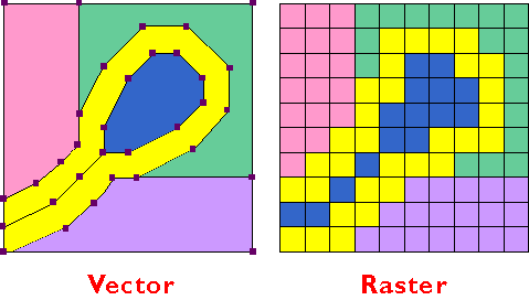
Like map overlay, buffering has been implemented in both vector and raster systems. The vector implementation involves expanding a selected feature or features, or producing new surrounding features (polygons). The raster implementation accomplishes the same thing, except that buffers consist of sets of pixels rather than discrete features. You can view both methods in Figure 9.12 below. What issue can you see below that may be a concern with using raster data for buffering? What needs to be done to minimize the issue?