The interpretability of multispectral images can be improved through the spectral enhancement of the image. Such enhancements can either be temporary and reversible, or they can result in the creation of new data layers. Image enhancements that are commonly used to support the analysis of remotely sensed imagery.
Color Assignment for Computer Displays
By now, you should be familiar with the characteristics of the natural color image, the image which most closely resembles what you would expect to see looking down at earth from a plane. To create a natural color image, the spectral bands from the image are matched directly to the representative color display channels, or color guns, of the computer. For example, the red spectral band of a Landsat Image is matched to the Red color display channel on the computer, while the Green spectral band is matched to the Green color display and so on. In Figure 1.a, the natural colors of the scene provide adequate contrast between the urban areas and the forest; however, when compared to the other images in this figure, you will notice additional features that are not readily apparent in this natural color image. The reassignment of spectral bands to different color guns can improve the visibility of some image feature.
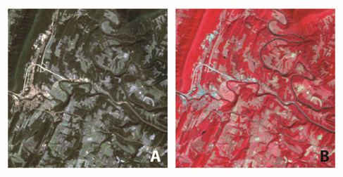
False-color-composite images are frequently used in remote sensing. The false-color-composite image is created by assigning spectral bands to color guns in combinations that do not create a natural color image. A common false-color-composite image used to support analysis of vegetation reassigns the near-infrared spectral band to the red color gun, the red spectral band to the green color gun, and the green spectral band to the blue color gun. The image that results from this combination is very different than the natural color image that you are used to seeing, as shown in Figure 1.b.
The major benefit of the false-color-composite is the increased ability to detect variations in vegetation due to the fact that vegetation strongly reflects NIR energy. In Figure 1.b, notice that it becomes easier to identify water features from the forested areas. In the natural color image, the lake in the lower left-hand corner blends in with the surrounding forest cover; the false-color-composite image highlights the lake's location. Fallow fields are evidenced by bright blue and white colors, while fields where crops have already grown are shown in the light pink angular patches that scatter across the darker red forests.