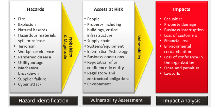
Risk Assessment
Risk Assessment involves weighing the impact of threats, positive or negative, on objectives and finding the best ways to control the risk by accepting, avoiding, transferring, or mitigating the effects of those threats and communicating it in a succinct and quality manner.
Risk is typically assessed across the following geospatial parameters:
- Probability of something going wrong, e.g. hazard due to physical changes, environmental, man-made, man-induced, collateral or incidental events
- Exposure of people, assets, civil and business entities
- The negative consequnces; vulnerability of personal, societal, and economic conditions
The goal is to consider the potential damages, losses, and/or mitigation of risk. For example, the risk posed by severe storms can be analyzed by looking at weather hotspots (cyclone, tornado, hurricane, lightening, etc., frequency) and calculating the exposure through population density. High-resolution satellite data can be used to derive physical risk and exposure data in combination with GPS data collection.
Risk is inherent to business and needs to be analyzed in terms of potential threats from within the organization (employees, production, administration, etc.), potential threats from outside the organization (customers, vendors, partners, products, services, etc.) and from the supply chain(s) in which it exists (raw materials, original equipment manufacturers, etc.). For manufacturers, it is important to examine the risks in their total value-adding chain starting with raw materials, importer through transporter, supplier, marketer, processor, wholesaler, distributor, retailer, maintainer, to consumer. For service providers, an analogous value-adding chain exists.
Sustainability
Through our work as geospatial data scientists, business professionals, or conscientious citizens, we share a responsibility to preserve the resources of our planet. Sustainability is commonly referred to as an ability for humans and the biosphere to continually coexist. More specifically, environmental sustainability combines the responsiblity to maintain environmental quality, preserve natural resources, and minimize the depletion of air, land, and water resources. Similar risks to human life, outlined in a Risk Management program, may threaten the vitality of the environment near business locations, along the supply chain, and as a result of improper disposal of hazardous materials.
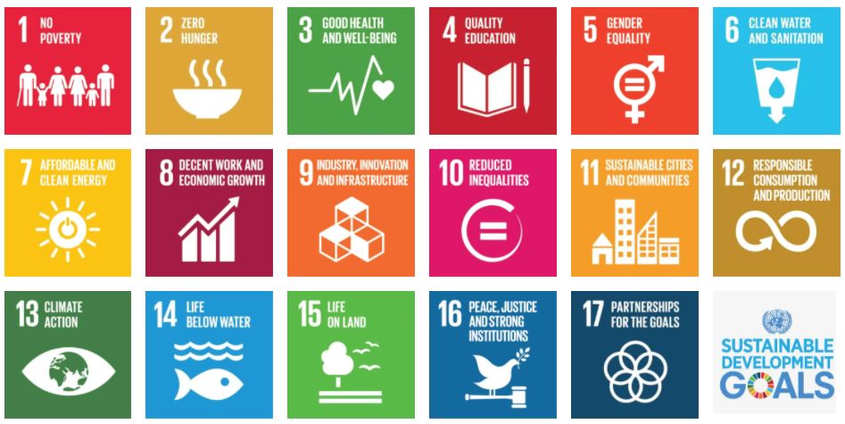
The convergence of Economy, Society, and Environment has resulted in a range of model sustainablity programs to unsustainable and devastating depletion of resources, e.g. potable drinking water, ozone in the atmosphere, and arable soil for agriculture. The United Nations Educational, Scientific, and Cultural Organization (UNESCO) provides educational materials, Education for Sustainable Development (Figure 5.2) to "empower everyone to make informed decisions in favour of environmental integrity, economic viability and a just society for present and future generations." (https://en.unesco.org/themes/education/sdgs/material) These development goals are key elements of their 2030 Agenda for Sustainable Development.
Crisis Management
Crisis Management is the process by which an organization deals with a major event that threatens to harm the organization, its stakeholders, or the general public. Three elements are common to most definitions of crisis: (a) a threat to the organization, (b) the element of surprise, and (c) a short decision time. Usually, Crisis management involves dealing with events as they occur or right after they occur.
The need to develop information science and technology to support crisis management has never been more apparent. Crisis management, for events such as hurricanes, forest fires, disease outbreaks, chemical spills, and terrorist attacks, relies upon geospatial information about the event itself, its causes, the people and infrastructure affected, resources available to respond, and more. Geospatial data and tools are an essential part of all aspects of crisis management—from planning for future crises, through response and recovery, to the mitigation of a possible crisis. In all aspects of crisis management, geospatial data and tools have the potential to contribute to the saving of lives, the limitation of damage, and the reduction in the costs to and impact on society.
For example, responders who know where impacts are greatest, where critical assets are stored, or where infrastructure is likely to be damaged are able to act more quickly, especially during the “golden hour” immediately after the event when there is the greatest possibility of saving lives. Geospatial data collected and distributed rapidly in the form of useful products allows response to proceed without the confusion that often occurs in the absence of critically important information. Indeed, it is impossible to imagine the chaos that would result if first responders were entirely unfamiliar with an area and had none of the geospatial information—maps, GPS coordinates, images, human conditions and cultures, all essential to effective management.
Read:
With the above definitions setting context, skim the following, spending time on tables and flowcharts—notice the interplay between the two above topics.
- Disaster Risk and Site Selection, Dennis Donovan, 2002
- Murphy, Geography, Why It Matters, Ch.4 "Nature and Society" (pp.87-109)
- Ryerson, et. al., Why Where Matters, Sections 3.2.4, “Mapping On-Demand/Traditional Mapping”
- A Risk Management Standard, published by the Federation of European Risk Management Associations
- Note: Pay special attention to graphics on page 4 (which shows examples of internal and external risks) and page 5 (which suggests a process for addressing risk.) You may find these two graphics, among others, helpful in sections 7.3-7.5.
- GIS Technology for Disasters and Emergency Management, Esri, Russ Johnson, 2000
The Geography: Why it Matters reading is from the required textbook for this course.
Registered students can access the other readings in Canvas on the Lesson 5 Readings page.
Do: Business Risk Management
Returning to the article on "Disaster Risk and Site Selection," consider risk minimization: How is site selection (essentially, location) tied to this take on dealing with disaster risks?
Deliverable
Post a comment in Canvas to the Lesson 5.1 - Risk Assessment forum including:
- one clear example of a risk to a business that experienced a critical disaster loss or damage, and
- how the business risk was minimized and what actions were taken to manage the crisis.
- You're welcome to post an additional example (from a different organization or scenario), if one comes to mind, for us to discuss.
Due Tuesday 11:59 pm (Eastern Time)
Check the calendar in Canvas for specific time frames and due dates.